
Geisenfeld
| coat of arms | Germany map | |
|---|---|---|

|
Coordinates: 48 ° 41 ′ N , 11 ° 37 ′ E |
|
| Basic data | ||
| State : | Bavaria | |
| Administrative region : | Upper Bavaria | |
| County : | Pfaffenhofen on the Ilm | |
| Management Community : | Geisenfeld | |
| Height : | 385 m above sea level NHN | |
| Area : | 88.31 km 2 | |
| Residents: | 11,473 (Dec. 31, 2019) | |
| Population density : | 130 inhabitants per km 2 | |
| Postal code : | 85290 | |
| Area code : | 08452 | |
| License plate : | PAF | |
| Community key : | 09 1 86 122 | |
| LOCODE : | DE GEX | |
| City structure: | 32 parts of the community | |
City administration address : |
Kirchplatz 4 85290 Geisenfeld |
|
| Website : | ||
| Mayor : | Paul Weber ( Independent Social Citizens ) | |
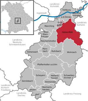
| Location of the city of Geisenfeld in the Pfaffenhofen an der Ilm district | ||
  |
||

Geisenfeld is a town in the Upper Bavarian district of Pfaffenhofen an der Ilm and, together with the municipality of Ernsgaden, forms the Geisenfeld administrative community .
geography
location
Geisenfeld is located in the Hallertau hop country , directly on the Ilm . The next big city is Ingolstadt, about 20 km away .
Further distances: Munich : 70 km Regensburg : 65 km Nuremberg : 100 km Augsburg : 70 km
Neighboring communities
Neighboring communities of Geisenfeld are Aiglsbach , Ernsgaden , Mainburg , Manching , Münchsmünster , Neustadt an der Donau , Reichertshofen , Rohrbach , Vohburg an der Donau , Wolnzach .
Community structure
The municipality has 32 officially named municipal parts (the type of settlement is given in brackets ):
|
|
|
|
history


Until the church is planted
Between 500 and 700 the place was founded by immigrant Bavarians . The leader of the clan that settled here was a man named Gisil, from whom the settlement got its name (Gisilfeld, Gisinvelt, Gisenvelt). In 736 the first hop cultivation took place through immigrant Wends and with it the foundation of the Hallertau. Count Eberhard II of Sempt and Ebersberg founded the Benedictine monastery in Geisenfeld in 1037 . In 1230 the Ainau Church was built in place of the Ainau Castle. In 1281 or 1310 the place was raised to a market town . Between 1407 and 1409 a curtain wall was built around Geisenfeld. In 1410 the construction of the Vitus Church in Geisenfeldzüge began. The establishment of a permanent post office took place in 1558, the construction of the town hall with the representation of Justitia by Balthasar Stoll in 1626. From 1701 to 1712 the monastery buildings were rebuilt, in 1728 the south tower of the monastery church was built. In 1789 Geisenfeld received the office of game master . In 1803 the monastery was dissolved in the course of secularization , and in 1804 the monastery church was converted into a parish church. In 1805 the curtain wall was torn down. In 1816 Geisenfeld was given a gendarmerie station , and in 1818 today's political community was established.
19th to 21st century
The first street lighting was installed in 1839 and the hospital opened in 1842. In 1862 a regional court was set up which was responsible for 39 municipalities. In 1879 the regional court was renamed the district court .
In 1874 the "Geisenfelder Wochenblatt" appeared for the first time. In 1888 there was the first telephone in Geisenfeld. Geisenfeld received electric light from 1899 to 1900. In 1905 there was a first automobile in Geisenfeld, the owner is the brewery owner Josef Münch. In 1906 the Geisenfeld – Wolnzach train station was opened. In 1952 the place received city rights , the district court Geisenfeld is dissolved in 1972. Eleven incorporations took place between 1971 and 1978 (see below). In 1983 the new town hall was opened, and in 1985 the hospital was converted into a senior citizens' home. In 1989 the railway line is closed. In 2002 the flood clearance is completed.
Development of the urban area
Geisenfeld has been a town since November 23, 1952 . From an economic point of view, the city of Geisenfeld, as a sub-center, is still the center of the northern district of Pfaffenhofen. Numerous medium-sized companies offer many residents jobs on site.
Incorporations
On April 1, 1971, the following previously independent communities were incorporated: Engelbrechtsmünster , Gaden (with Wasenstadt and Furthof), Geisenfeldzüge , Parleiten (with Eichelberg, Holzleiten and Scheuerhof) and Schillwitzried (with Schillwitzhausen, Schafhof and Gießübel). On July 1, 1971 Nötting , Untermettenbach (with Obermettenbach and Ziegelstadel) and Unterpindhart (with Kolmhof, Untereulenthal and Obereulenthal) followed. Rottenegg (with Hornlohe, Moosmühle and Brunn), Zell (with Ainau , Ritterswörth , Unterzell and Oberzell) and Ilmendorf (with Einberg) were added on January 1, 1978.
Population development
Between 1988 and 2018 the city grew from 7,753 to 11,363 by 3,610 inhabitants or 46.6%.
|
|
|
footnote
politics
City council
The Geisenfeld city council consists of 24 city councilors and the mayor. In the city council election on March 15, 2020 , the distribution of seats was as follows:

| CSU (Christian Social Union) | 6 seats |
| FW (Free Voters) | 6 seats |
| USB (Independent Social Citizens) | 6 seats |
| BLG (Geisenfeld Citizens List) | 2 seats |
| ILM (Initiative for Living Together) | 2 seats |
| AfD (alternative for Germany) | 1 seat |
| CDG (Christian Democrats Geisenfeld) | 1 seat |
mayor
Paul Weber has been mayor of the city since May 2020. He replaced Christian Staudter, who had held the office since 2008.
coat of arms
|
|
Blazon : "A silver zigzag bar in the red triangular shield." |
The origin of the coat of arms has not yet been clearly established. It is believed that it is derived from the coat of arms of the Geisenfeld monastery. The oldest colored reproductions of the coat of arms date from 1565, 1568 and 1590. They show the silver zigzag bar in the red field. In 1818 the colors were reversed due to a mistake by the then magistrate under Mayor Anton Stephan. Since then, the official mayor's seal has had the red zigzag bar. However, the silver zigzag bar on a red field is preferred for colored reproductions of the coat of arms.
Culture and sights
Educational institutions
Elementary school, state secondary school, special needs school, adult education center, music school, four municipal kindergartens, Catholic kindergarten, daycare center, day nursery
Attractions

- Ensemble with the mighty monastery wing and the parish church
- Benedictine monastery Geisenfeld in which the Hallertau hops and local history museum is to be housed after renovation
- City parish church of St. Emmeram with its two towers - the compact Romanesque “donor tower” and the Renaissance-style structure with an onion dome that was raised by several floors from 1727–1730. The altarpiece "Assumption of Mary" was painted by the Veronese painter Marc Antonio Bassetti in 1620 in Rome . The church is also known colloquially as Hallertau Cathedral.
- Old Town Hall (built 1626)
- Church of St. Ulrich in Ainau: The Romanesque portal is one of the most important sights in the district
- 300-year-old linden church in the Geisenfeldzüge district, which, however, was partially destroyed by storm Kyrill
landscape
The area around Geisenfeld is, like large parts of the Hallertau, very hilly. The soil is partly very loamy, which is very beneficial for hop growing. In the north of Geisenfeld a belt stretches from west ( Feilenforst ) to east ( Dürnbucher Forst ) with heavy forest cover.
music
The following music associations and groups are based in Geisenfeld:
- Singers' Association
- Geisenfeld town chapel
- Tin toys
- Church choir of the parish of St. Emmeram
- Maggie's modernity
- Geisenfelder black woodwind
- Singing circle results
- Bavarian Singing Circle
- Geisenfeld Highlanders
- Geisenfeld singers
- The Blech-AG
- Geri & the Wagtails
Nature reserve
- Nöttinger Viehweide - Badertaferl in the north of Geisenfeld (almost 150 hectares in the file forest)
Freetime activities
- River hiking on the Ilm
- Bike tours around Geisenfeld
- Feilenmoos local recreation area
- Hiking in the file forest
- Go for a walk in the Nöttinger Heide
- Bathing pond with surfing opportunities
- Indoor swimming pool
- Football and soccer fields
- playgrounds
- Tennis courts
- Wakeboard and water ski lift
- "Skate field"
- Sledge mountain
Regular events
- Schäfflertanz (every 7 years)
- Citizen Festival
- FC Geisenfeld wine festival (always on the third weekend in July)
- 24 hour run
- Folk festival, always in mid-September
- Culture days in autumn
- Christmas market
- Open-air cinema
- Geisenfeld holiday pass
- Ainau Art Days (always on the second weekend in July)
theatre
- Nöttinger theater friends
- Theater department of HSV Rottenegg
Sports
- MSC Geisenfeld (model flying club)
- TV Geisenfeld
- Tri Team Geisenfeld
- FC Geisenfeld (football club)
- TC Geisenfeld (tennis club)
- Geisenfeld Surf Club
- SpVgg Engelbrechtsmünster (football club)
- FC Unterpindhart (football club with a department for jogging and Nordic walking)
- HSV Rottenegg (football club with a theater department)
- Geisenfeld carnival society
- royal private monastery riflemen Geisenfeld (rifle club)
- Horse friends Geisenfeld (riding)
- Taekwon-Do Center Geisenfeld
Social
- BRK readiness Geisenfeld
- BRK water rescue service Geisenfeld
Economy and Infrastructure
Established businesses
(Selection)
traffic
The next train stations are in the south in Rohrbach on the Munich – Ingolstadt railway line and in the north in Ernsgaden on the Danube Valley Railway . Geisenfeld was directly connected to the railway network via the Wolnzach – Geisenfeld railway line, which opened in 1906 , but passenger transport was replaced by a railway bus line as early as December 1953 . Freight trains ran until 1987, in March 1988 the rail connection was formally shut down and then dismantled.
The federal highway 300 runs through Geisenfeld . The BAB 9 ( Langenbruck junction ) can be reached via them . The Mainburg junction of the BAB 93 is also nearby.
Personalities
sons and daughters of the town
- Herenäus Haid (1784–1873), theologian, author and translator
- Gregor Strasser (1892–1934), National Socialist politician, publisher and participant in the Hitler-Ludendorff putsch
- Markus Anton (* 1976), German actor and poet
Notable people
- Richard Adolf Strigl (1926–1985), Catholic theologian
- Andreas Martin Hofmeir (* 1978), musician, cabaret artist and university professor
literature
- Michael Trost: History of the Geisenfeld market. Appendix, containing historical information about the parish village of Ainau . In: Upper Bavarian Archive for Fatherland History (Historischen Verein von Oberbayern, Ed.), Volume 38, Munich 1879, pp. 42–72. ( online ).
Web links
Individual evidence
- ↑ "Data 2" sheet, Statistical Report A1200C 202041 Population of the municipalities, districts and administrative districts 1st quarter 2020 (population based on the 2011 census) ( help ).
- ^ Geisenfeld community in the local database of the Bavarian State Library Online . Bayerische Staatsbibliothek, accessed on September 12, 2019.
- ↑ City and VGem Geisenfeld - 60 years of the city elevation Geisenfeld. Retrieved October 21, 2019 .
- ^ Wilhelm Volkert (ed.): Handbook of Bavarian offices, communities and courts 1799–1980 . CH Beck, Munich 1983, ISBN 3-406-09669-7 , p. 550 .
- ^ Federal Statistical Office (ed.): Historical municipality directory for the Federal Republic of Germany. Name, border and key number changes in municipalities, counties and administrative districts from May 27, 1970 to December 31, 1982 . W. Kohlhammer, Stuttgart / Mainz 1983, ISBN 3-17-003263-1 , p. 586 .
- ↑ Mayor. Congregation, accessed July 18, 2020 .
- ↑ http://www.wahlen.bayern.de/kommunalwahlen/
- ^ Entry on the Geisenfeld coat of arms in the database of the House of Bavarian History

Ainau Brunn | Eichelberg | Einberg | Engelbrechtsmünster | Furthof | Gaden near Geisenfeld | Geisenfeldwinds | Pouring bucket | Holzleiten | Hornlohe | Ilmendorf | Kolmhof | Moss mill | Nötting | Obereulenthal | Obermettenbach | Parrying | Ritterswörth | Rottenegg | Sheep farm | Scheuerhof | Schillwitzhausen | Schillwitzried | Untereulenthal | Untermettenbach | Unterpindhart | Wasenstadt | Weather mill | Cell | Brick barn