
Pörnbach
| coat of arms | Germany map | |
|---|---|---|

|
Coordinates: 48 ° 37 ' N , 11 ° 28' E |
|
| Basic data | ||
| State : | Bavaria | |
| Administrative region : | Upper Bavaria | |
| County : | Pfaffenhofen on the Ilm | |
| Management Community : | Reichertshofen | |
| Height : | 396 m above sea level NHN | |
| Area : | 22.63 km 2 | |
| Residents: | 2175 (Dec. 31, 2019) | |
| Population density : | 96 inhabitants per km 2 | |
| Postal code : | 85309 | |
| Area code : | 08446 | |
| License plate : | PAF | |
| Community key : | 09 1 86 144 | |
| LOCODE : | DE PB9 | |
| Community structure: | 6 parts of the community | |
| Address of the municipal administration: |
Kirchplatz 1 85309 Pörnbach |
|
| Website : | ||
| Mayor : | Helmut Bergwínkel ( FUW ) | |
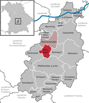
| Location of the municipality of Pörnbach in the Pfaffenhofen an der Ilm district | ||
  |
||


Pörnbach is a municipality in the Upper Bavarian district Pfaffenhofen and forms with the market Reichertshofen the Verwaltungsgemeinschaft Reichertshofen .
geography
Pörnbach is located in the Hallertau in the north-western part of the Pfaffenhofen district and is part of the Ingolstadt planning region .
The municipality has six officially named municipality parts (the type of settlement is given in brackets ):
- Maushof ( hamlet )
- Oberkreut (hamlet)
- Pörnbach ( parish village )
- Puch (parish village)
- Raitbach ( Kirchdorf )
- Unterkreut ( wasteland )
There are the districts Puch, Pörnbach and Raitbach.
history
Until the church is planted
Pörnbach belonged to the Counts of Toerring -Gronsfeld. Toerring's castle was first mentioned in 1558, but has not been inhabited by members of the family since the middle of the 18th century at the latest. The place was part of the Electorate of Bavaria , but formed a closed Hofmark . From 1663 to 1848, the Counts of Törring owned the Hofmark Pörnbach, a property complex consisting of nine originally independent court brands. The administrative center of the court brands Pörnbach, Euernbach , Göbelsbach , Tegernbach , Ritterswörth , Burgstall , Eschelbach , Förnbach and Puch, which had been the patrimonial courts of the Counts of Törring-Jettenbach since 1819/20 , was in Pörnbach. In the course of the administrative reforms in Bavaria , today's municipality was created with the municipal edict of 1818 . Patrimonial jurisdiction was abolished in the revolution of 1848.
Administrative community
With the Reichertshofen market , there has been an administrative partnership since January 1st, 1978.
Incorporations
On January 1, 1971, the previously independent municipality of Raitbach was incorporated. On January 1, 1978, Puch joined them.
Population development
Between 1988 and 2018 the municipality grew from 1,532 to 2,170 by 638 inhabitants or by 41.6%.
- 1961: 1321 inhabitants
- 1970: 1365 inhabitants
- 1987: 1485 inhabitants
- 1991: 1696 inhabitants
- 1995: 1751 inhabitants
- 2000: 1817 inhabitants
- 2005: 1976 inhabitants
- 2010: 2116 inhabitants
- 2015: 2140 inhabitants
The population figures refer to today's municipality.
politics
mayor
Mayor has been Helmut Bergwinkel (Progressive Independent) since 2014. He was re-elected in 2020 . Alois Ilmberger (village community) held office until 2014.
Municipal council
After the local elections in Bavaria 2020, the municipal council consists of a total of 14 members (excluding the First Mayor) according to the following distribution of seats:
- Progressive Independent Voting Community: 7 seats (51.7% of the vote)
- Village community / voter community Puch: 7 seats (48.3% of the votes)
The turnout was 67.2%.
coat of arms
Blazon : In silver a blue wavy bar, above three, two to one, red roses with golden lugs, below a red post horn.
Architectural monuments
- Toerring Castle
- Catholic Parish Church of St. John the Baptist
- Vicarage and Gasthof zur Post
- Catholic Expositur Church St. Martin in Puch
- Catholic branch church St. Erhard in Raitbach
Soil monuments
Economy and Infrastructure
Economy including agriculture and forestry
In 1998, according to official statistics, there were no employees at the place of work in the manufacturing sector or in the trade and transport sector. The brewery belonging to Toerring'schen Schloss now exclusively produces non-alcoholic beverages at the Pörnbach location. In other economic sectors, 44 people were employed at the place of work subject to social security contributions. There were a total of 590 employees at the place of residence subject to social security contributions. There were none in the manufacturing sector and three in the construction sector. In addition, there were 63 farms in 1999 with an agricultural area of 1060 ha, of which 799 ha were arable land.
traffic
Pörnbach lies at the intersection of federal highway 13 (Munich-Ingolstadt) and federal highway 300 (Augsburg-direction Regensburg). The Gasthof zur Post, built at the beginning of the 19th century, points to the central location of Pörnbach at the crossroads of the former post roads from and to Ingolstadt, Regensburg, Munich and Augsburg. The Pörnbach post office had existed since 1803. The post horn in the Pörnbach coat of arms symbolizes the former importance of the place in terms of transport and geography. These post roads were the predecessors of today's federal highways 13 and 300. Until the 1970s, the B 300 also ran through the middle of the village (Oberkreut-Pörnbach-Puch-Langenbruck), until the bypass from the A9 was built past Reichertshofen and Pörnbach. It has not yet been possible to bypass Pörnbach along the B13.
education
There are the following institutions (status: 2013):
- Day nursery: two groups with twelve children each
- Kindergarten: 50 kindergarten places with 57 children
- Elementary school: elementary school (1st to 4th grade)
Web links
- Entry on the coat of arms of Pörnbach in the database of the House of Bavarian History
Individual evidence
- ↑ "Data 2" sheet, Statistical Report A1200C 202041 Population of the municipalities, districts and administrative districts 1st quarter 2020 (population based on the 2011 census) ( help ).
- ^ Parish Pörnbach in the local database of the Bayerische Landesbibliothek Online . Bayerische Staatsbibliothek, accessed on September 12, 2019.
- ^ Wilhelm Volkert (ed.): Handbook of Bavarian offices, communities and courts 1799–1980 . CH Beck, Munich 1983, ISBN 3-406-09669-7 , p. 550 .
- ^ Federal Statistical Office (ed.): Historical municipality directory for the Federal Republic of Germany. Name, border and key number changes in municipalities, counties and administrative districts from May 27, 1970 to December 31, 1982 . W. Kohlhammer, Stuttgart / Mainz 1983, ISBN 3-17-003263-1 , p. 586 .
- ↑ Result on the administrative community page , accessed on May 29, 2020
- ^ House of Bavarian History - Bavaria's municipalities. Retrieved September 18, 2019 .
