
Geisenfeld administrative community
| coat of arms | Germany map | |
|---|---|---|
 Help on coat of arms |
Coordinates: 48 ° 41 ′ N , 11 ° 37 ′ E |
|
| Basic data | ||
| State : | Bavaria | |
| Administrative region : | Upper Bavaria | |
| County : | Pfaffenhofen on the Ilm | |
| Area : | 95.8 km 2 | |
| Residents: | 13,183 (Dec. 31, 2019) | |
| Population density : | 138 inhabitants per km 2 | |
| License plate : | PAF | |
| Association key : | 09 1 86 5156 | |
| Association structure: | 2 municipalities | |
| Association administration address : |
Kirchplatz 4 85290 Geisenfeld |
|
| Website : | ||
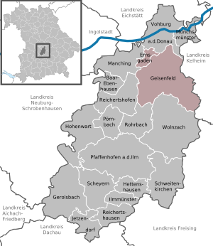
| Location of the Geisenfeld administrative community in the Pfaffenhofen an der Ilm district | ||
  |
||

The Geisenfeld administrative community is located in the Upper Bavarian district of Pfaffenhofen an der Ilm and is formed by the following communities:
- Ernsgaden , 1710 inhabitants, 7.5 km²
- Geisenfeld , town with 11,473 inhabitants, 88.31 km²
The administrative community is based in Geisenfeld.
Individual evidence
- ↑ "Data 2" sheet, Statistical Report A1200C 202041 Population of the municipalities, districts and administrative districts 1st quarter 2020 (population based on the 2011 census) ( help ).
Administrative communities in the Pfaffenhofen an der Ilm district
Geisenfeld | Ilmmünster | Reichertshofen
Disbanded: Reichertshausen