
Administrative community Ilmmünster
| coat of arms | Germany map | |
|---|---|---|
 Help on coat of arms |
Coordinates: 48 ° 29 ' N , 11 ° 30' E |
|
| Basic data | ||
| Existing period: | 1980– | |
| State : | Bavaria | |
| Administrative region : | Upper Bavaria | |
| County : | Pfaffenhofen on the Ilm | |
| Area : | 32.48 km 2 | |
| Residents: | 4356 (Dec. 31, 2019) | |
| Population density : | 134 inhabitants per km 2 | |
| License plate : | PAF | |
| Association key : | 09 1 86 5157 | |
| Association structure: | 2 municipalities | |
| Association administration address : |
Freisinger Str. 3 85304 Ilmmünster |
|
| Website : | ||
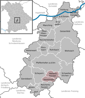
| Location of the Ilmmünster administrative community in the Pfaffenhofen an der Ilm district | ||
  |
||

The administrative community Ilmmünster is located in the Upper Bavarian district of Pfaffenhofen an der Ilm and is formed by the following communities:
- Hettenshausen , 2088 inhabitants, 18.59 km²
- Ilmmünster , 2268 inhabitants, 13.89 km²
The administrative association is based in Ilmmünster.
Since May 1, 1978, both communities belonged to the Reichertshausen administrative community, which was dissolved on December 31, 1979 . The Ilmmünster administrative community was formed on January 1, 1980.
Individual evidence
- ↑ "Data 2" sheet, Statistical Report A1200C 202041 Population of the municipalities, districts and administrative districts 1st quarter 2020 (population based on the 2011 census) ( help ).
- ↑ Law of August 10, 1979 (GVBl p. 223)
Administrative communities in the Pfaffenhofen an der Ilm district
Geisenfeld | Ilmmünster | Reichertshofen
Disbanded: Reichertshausen