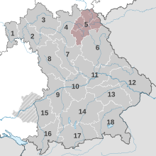
Planning region Upper Franconia East
The Upper Franconia East planning region is one of a total of 18 planning regions in the Free State of Bavaria . The administrative seat is in Hof (Saale)
structure
The Upper Franconia East planning region is located in northern Bavaria and is part of the Upper Franconia administrative region. The following bodies are united in the regional planning association: the independent cities of Bayreuth and Hof , the districts of Bayreuth , Hof , Kulmbach and Wunsiedel in the Fichtelgebirge as well as the associated district communities. In addition, the municipality of Waldershof in the Tirschenreuth district is part of the association area (the other municipalities are part of the Upper Palatinate North planning region ).
Upper centers are the cities of Bayreuth and Hof . Associated middle areas are Kulmbach , Marktredwitz / Wunsiedel / Waldershof , Münchberg , Naila , Pegnitz and Selb , with Kulmbach and Marktredwitz / Wunsiedel / Waldershof being possible further regional centers.
On December 31, 2016, just under 470,000 people lived in the region, around 50,000 of them in Hof and almost 75,000 in Bayreuth.
history
In 1972 the Free State of Bavaria was divided into 18 planning regions on the basis of the Bavarian State Planning Act of 1970. The Regional Planning Association was established in 1973. The current chairman of the association has been the Lord Mayor of Hof Harald Fichtner since June 2006 .
