
Essing
| coat of arms | Germany map | |
|---|---|---|

|
Coordinates: 48 ° 56 ' N , 11 ° 47' E |
|
| Basic data | ||
| State : | Bavaria | |
| Administrative region : | Lower Bavaria | |
| County : | Kelheim | |
| Management Community : | Ihrlerstein | |
| Height : | 351 m above sea level NHN | |
| Area : | 17.34 km 2 | |
| Residents: | 1091 (Dec. 31, 2019) | |
| Population density : | 63 inhabitants per km 2 | |
| Postal code : | 93343 | |
| Area code : | 09447 | |
| License plate : | KEH, MAY , PAR , RID, ROL | |
| Community key : | 09 2 73 121 | |
| Association administration address: | Main street 15 93346 Ihrlerstein |
|
| Website : | ||
| Mayor : | Jörg Nowy ( Free Christian Voters ) | |
| Location of the Essing market in the Kelheim district | ||
  |
||

Essing is a market in the Altmühltal in the Lower Bavarian district of Kelheim in Bavaria .
geography
The community is located in the Altmühltal Nature Park and in the Regensburg planning region .
It consists of 15 districts:
|
|
|
There are the districts Altessing, Neuessing, Randeck
history

Early history
Essing was first mentioned in a document in 976. Randeck Castle above the Essing market was built around the year 1000 and is one of the oldest castles in Bavaria. The town, which was raised to the market in 1336, later belonged to the Munich Rent Office and the Abensberg Regional Court of the Electorate of Bavaria . Essing (= Neuessing) had a market court with its own magistrate rights.
.jpg)
20th century
In 1924 the previously independent municipality of Randeck was incorporated into Altessing. In 1938 Altessing and Neuessing were merged to form the new municipality of Essing.
Population development
In the period from 1988 to 2018, the population increased from 965 to 1,025 by 60 inhabitants or 6.2%.
- 1970: 996 inhabitants
- 1987: 970 inhabitants
- 1991: 1002 inhabitants
- 1995: 1012 inhabitants
- 2000: 1032 inhabitants
- 2005: 1018 inhabitants
- 2010: 1004 inhabitants
- 2015: 1032 inhabitants
politics
The community is a member of the Ihrlerstein administrative community . Jörg Nowy (Free Christian Voting Association) has been the mayor since March 1988.
coat of arms
|
|
Blazon : "A red armored blue heron with a blue fish in its beak standing in silver on a green three-mountain." |
Economy and Infrastructure
Economy including agriculture and forestry
In 1998 there were no employees in the field of agriculture and forestry, 98 in the manufacturing sector and no employees in the field of trade and transport at the place of work. There were 344 employees at the place of residence subject to social security contributions. There were none in manufacturing and two in construction. In addition, in 1999 there were 16 agricultural holdings with an agricultural area of 232 ha. 161 ha of this was arable land.
education
In 1999 the following institutions existed:
- Kindergartens: 25 kindergarten places with 24 children
Attractions
- Wooden bridge near Essing - a wooden tension band bridge over the Altmühl and the Main-Danube Canal . The 190 m long bridge was the longest tension band bridge in Europe when it opened in 1986. The structure consists of glued wooden panels. The bridge body is popularly known as the Tatzelwurm because of its elegant undulating curve . To mark the opening of the Main-Danube Canal, the Deutsche Bundespost issued a postage stamp with the Essingen bridge motif in 1992.

- An older, only 48 m long wooden bridge leads over an old branch of the Altmühl into the town center. It is guarded by the Bruck Gate , an originally Gothic gate tower that has been rebuilt several times and is now privately owned. Joseph Michael Neustifter placed a bronze memorial on this old wooden bridge to Josef Deifl (1790–1864), a Bavarian infantryman born in Essing .
- The Essinger Kunstweg runs through the Altmühlauen along rocks and rivers , a sculpture path with works by Werner Engelmann , Willi Hengge and other, sometimes changing, artists who temporarily exhibit their works here.
- There is a medieval well on the market square, which was converted into a pump well in 1818. In 1974 the old well basket was brought back.
- The former collegiate monastery Neuessing is located on the southern edge of the village.
The Jura Landscape Adventure Trail (part of the Jurasteig ) and the hiking trails branching off from it open up the following attractions outside of the town center:
- Blautopf ( karst spring and geotope )
- Randeck Castle
- Klausenhöhle ( karst cave , prehistoric dwellings and geotope)
- Schulerloch , show cave and the surrounding nature reserve Schulerloch
- Armchair rock grotto , rock face with karst cave

Essing and Randeck castle ruins

Randeck castle ruins

Essing with Kunstweg in autumn 2005

Blautopf from Essing

Essing with Altmühlbrücke

Essing with Holy Spirit Church
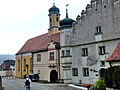
Essing, Holy Spirit Church and collegial monastery
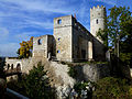
Randeck castle ruins

Bridge gate

Essing an der Altmühl

Wooden bridge in Essing


2.JPG)


.JPG)
.JPG)
.JPG)
Personalities
- Gozbert († 1001), abbot of the Tegernsee monastery
- Josef Deifl (1790–1864), as a soldier in the Bavarian Army, described his war experiences from 1805 to 1815 in an unusually detailed diary.
Web links
- Essing market
- The chair rock grotto in Neuessing ( Memento from March 22, 2014 in the Internet Archive )
- Excursion to the Klausen caves
- Essing: Official statistics of the LfStat
- http://panonaut.com/essing (link not available)
Individual evidence
- ↑ "Data 2" sheet, Statistical Report A1200C 202041 Population of the municipalities, districts and administrative districts 1st quarter 2020 (population based on the 2011 census) ( help ).
- ↑ The Essingen Market Council. Essing municipality, accessed on June 27, 2020 .
- ↑ Bavarian State Library Online
- ^ Wilhelm Volkert (ed.): Handbook of Bavarian offices, communities and courts 1799–1980 . CH Beck, Munich 1983, ISBN 3-406-09669-7 , p. 493 .
- ^ Entry on Essing's coat of arms in the database of the House of Bavarian History
- ↑ Josef Deifel

Abensberg | Aiglsbach | Attenhofen | Bad Abbach | Biburg | Elsendorf | Essing | Hausen | Herrngiersdorf | Ihrlerstein | Kelheim | Kirchdorf | Langquaid | Mainburg | Neustadt an der Donau | Painten | Riedenburg | Rohr in Lower Bavaria | Hall on the Danube | Siegenburg | Teugn | Train | Volkenschwand | Wildenberg
Unregulated areas: Dürnbucher Forst | Frauenforst | Hacklberg | Hienheim Forest