Kirchdorf (Hallertau)
| coat of arms | Germany map | |
|---|---|---|

|
Coordinates: 48 ° 46 ' N , 11 ° 55' E |
|
| Basic data | ||
| State : | Bavaria | |
| Administrative region : | Lower Bavaria | |
| County : | Kelheim | |
| Management Community : | Siegenburg | |
| Height : | 412 m above sea level NHN | |
| Area : | 16.49 km 2 | |
| Residents: | 932 (Dec. 31, 2019) | |
| Population density : | 57 inhabitants per km 2 | |
| Postal code : | 93348 | |
| Primaries : | 08783, 09444 | |
| License plate : | KEH, MAY , PAR , RID, ROL | |
| Community key : | 09 2 73 139 | |
| Association administration address: | Marienplatz 13 93354 Siegenburg |
|
| Website : | ||
| Mayor : | Alfred Schiller (UW) | |
| Location of the municipality of Kirchdorf in the Kelheim district | ||
Kirchdorf is a municipality in the Lower Bavarian district of Kelheim and a member of the Siegenburg administrative community .
geography
location
Kirchdorf lies in the Hallertau .
Districts
Districts are Allhofen, Allmersdorf , Hapfendorf, Jauchshofen, Kirchdorf, Mantelkirchen and Pickenbach.
history
Until the church is planted
Kirchdorf is first mentioned between 1075 and 1085. To distinguish it from other places with this name, “bej der Abens” was added in 1434. In the 11th century, Bishop Otto von Riedenburg donated property in Kirchdorf to the Regensburg Monastery of St. Paul . The Counts of Perusa were landlords and court lords in the Hofmark from the 18th century until 1785 . Kirchdorf belonged to the Straubing Rent Office and the Abensberg Regional Court of the Electorate of Bavaria .
In the course of the administrative reforms in Bavaria , today's political municipality was created with the municipal edict of 1818 .
Population development
In the period from 1988 to 2018, the population increased from 734 to 933 by 199 inhabitants or by 27.1%.
- 1961: 712 inhabitants
- 1970: 710 inhabitants
- 1987: 735 inhabitants
- 1991: 773 inhabitants
- 1995: 811 inhabitants
- 2000: 887 inhabitants
- 2005: 898 inhabitants
- 2010: 885 inhabitants
- 2015: 910 inhabitants
politics
mayor
Alfred Schiller (UW) has been the honorary mayor since May 2008. Despite his suspension in 2016, he was confirmed in office in March 2020 with 83 percent of the vote.
coat of arms
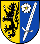
The description of the coat of arms reads: Split of gold and blue; in front a black crowned black lion, behind a slanting left silver sword, at the top flanked by a silver heraldic rose with a golden lug and golden sepals.
Architectural monuments
- The parish church of St. Elisabeth has a late Gothic choir. The tower, which is essentially medieval, was built around 1600, the nave with furnishings around 1750. On the churchyard wall there are grave monuments from the 17th to 19th centuries and a relief from around 1480.
- The old rectory, a two-story block building with a hipped roof, was built in the 18th century.
Economy and Infrastructure
Economy including agriculture and forestry
In 1998, according to official statistics, there were no employees at work subject to social security contributions in the manufacturing sector 48 or in the trade and transport sector. In other economic areas, 17 people were employed at the place of work subject to social security contributions. There were a total of 308 employees at the place of residence subject to social security contributions. There were two companies in the manufacturing sector and two companies in the construction sector. In addition, in 1999 there were 57 farms with an agriculturally used area of 1176 ha, of which 1102 ha were arable land and 73 ha were permanent green space.
education
The following institutions exist (as of: 1999):
- 25 kindergarten places with 26 children
Individual evidence
- ↑ "Data 2" sheet, Statistical Report A1200C 202041 Population of the municipalities, districts and administrative districts 1st quarter 2020 (population based on the 2011 census) ( help ).
- ↑ [1]
- ↑ [2]
Web links
- Entry on the coat of arms of Kirchdorf (Hallertau) in the database of the House of Bavarian History


