
Administrative community Siegenburg
| coat of arms | Germany map | |
|---|---|---|
 Help on coat of arms |
Coordinates: 48 ° 45 ' N , 11 ° 51' E |
|
| Basic data | ||
| Existing period: | May 01, 1978– | |
| State : | Bavaria | |
| Administrative region : | Lower Bavaria | |
| County : | Kelheim | |
| Area : | 86.87 km 2 | |
| Residents: | 9528 (Dec. 31, 2019) | |
| Population density : | 110 inhabitants per km 2 | |
| License plate : | KEH, MAY , PAR , RID, ROL | |
| Association key : | 09 2 73 5218 | |
| Association structure: | 5 municipalities | |
| Association administration address : |
Marienplatz 13 93354 Siegenburg |
|
| Chairman : | 1. Mayor Gerhard Zeitler Municipality of Train (UL - Train) | |
| Location of the Siegenburg administrative community in the Kelheim district | ||
  |
||

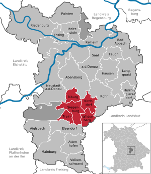
The administrative community Siegenburg is located in the Lower Bavarian district of Kelheim and is formed by the following communities:
- Biburg , 1287 inhabitants, 14.2 km²
- Kirchdorf , population 932, 16.49 km²
- Siegenburg , market , 4030 inhabitants, 27.86 km²
- Train , 1888 inhabitants, 10.16 km²
- Wildenberg , 1391 inhabitants, 18.16 km²
The administrative community is based in Siegenburg.
Individual evidence
- ↑ "Data 2" sheet, Statistical Report A1200C 202041 Population of the municipalities, districts and administrative districts 1st quarter 2020 (population based on the 2011 census) ( help ).
Administrative communities in the Kelheim district