Bad
| coat of arms | Germany map | |
|---|---|---|

|
Coordinates: 48 ° 54 ' N , 12 ° 1' E |
|
| Basic data | ||
| State : | Bavaria | |
| Administrative region : | Lower Bavaria | |
| County : | Kelheim | |
| Management Community : | Hall on the Danube | |
| Height : | 379 m above sea level NHN | |
| Area : | 17.09 km 2 | |
| Residents: | 1682 (Dec. 31, 2019) | |
| Population density : | 98 inhabitants per km 2 | |
| Postal code : | 93356 | |
| Area code : | 09405 | |
| License plate : | KEH, MAY , PAR , RID, ROL | |
| Community key : | 09 2 73 175 | |
| LOCODE : | DE TEB | |
| Association administration address: | Rathausstraße 4 93342 Saal adDonau |
|
| Website : | ||
| Mayor : | Manfred Jackermeier ( CSU ) | |
| Location of the municipality of Teugn in the Kelheim district | ||
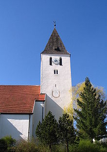
Teugn ( Bavarian : Deing ) is a municipality in the Lower Bavarian district of Kelheim and a member of the administrative community of Saal an der Donau .
geography
Teugn is in the Regensburg region.
There is only the district Teugn.
Parish parts
The community consists of 7 parts of the community: Gschwendhof, Hutmühle, Oberkager, Roith, Teugn, Thronhofen and Unterkager.
history
Until the church is planted
The first demonstrable settlement of the place was by Celts . In the 9th century, Teugn was acquired by Anno for the diocese of Freising. In 1002 gave King Henry II. His estate in Teugn the Episcopal Church of Brixen , which until 1803 due mistress remained.
Politically, Teugn belonged to the Straubing Rent Office and the Kelheim District Court of the Electorate of Bavaria for a long time . On April 19, 1809, the battle of Teugn-Hausen between Austrian and French troops took place on the heights south of the village during Napoleon's 5th coalition war . In 1818 the second community edict in the Kingdom of Bavaria gave rise to today's community.
20th century
Although the municipality of Teugn only had about 1100 inhabitants, it was able to obtain political independence during the municipal reform in Bavaria in 1978.
Population development
In the period from 1988 to 2018, the population increased from 1,249 to 1,692 by 443 inhabitants or 35.5%.
- 1961: 992 inhabitants
- 1970: 1076 inhabitants
- 1987: 1220 inhabitants
- 1991: 1289 inhabitants
- 1995: 1352 inhabitants
- 2000: 1451 inhabitants
- 2005: 1559 inhabitants
- 2010: 1604 inhabitants
- 2015: 1689 inhabitants
politics
mayor
Mayor is Manfred Jackermeier (CSU). He replaced Anton Schweiger (Free Voters) in the 2014 local elections. Both Schweiger and his predecessor Köglmeier Hans (CSU) were awarded the title of "Former Mayor".
tax income
The municipal tax income amounted to € 700,000 in 2010, of which the trade tax income (net) amounted to € 200,000.
coat of arms
| Blazon : "In silver, a red eagle with a golden bishop's staff placed across the chest, underneath a red paw cross." | |
| Foundation of the coat of arms: The coat of arms awarded in 1969 indicates the history of the place. The eagle with the bishop's staff symbolizes the manorial rule of the cathedral chapter of Brixen (South Tyrol) since it was donated by King Henry II in 1002. The paw cross as a symbol of the Georgskirche of the convent reminds of the property of the convent in the place. |
Architectural monuments

Economy and Infrastructure
Economy including agriculture and forestry
In 1998, according to official statistics, there were 76 employees at the place of work in the manufacturing sector and eight in the trade and transport sector. In other economic areas, 30 people were employed at the place of work subject to social security contributions. There were a total of 505 employees at the place of residence subject to social security contributions. There were four companies in the manufacturing sector and two in the construction sector. In addition, in 1999 there were 34 farms with an agricultural area of 767 ha, of which 687 ha were arable land.
There is a biogas plant in Teugn .
education
There are the following institutions (as of 2018):
- kindergarten
- primary school
Honorary citizen
- Hans Köglmeier (Former Mayor)
- Anton Schweiger (Former Mayor)
- Gerhard Merkl (1940–2016) (former Minister of State, Deputy District Administrator)
Individual evidence
- ↑ "Data 2" sheet, Statistical Report A1200C 202041 Population of the municipalities, districts and administrative districts 1st quarter 2020 (population based on the 2011 census) ( help ).
- ↑ Entry on Teugn's coat of arms in the database of the House of Bavarian History , accessed on August 6, 2020 .
- ↑ The creation of a municipal coat of arms . Retrieved August 6, 2020 .
Web links
- Entry on the coat of arms of Teugn in the database of the House of Bavarian History


