
Herrngiersdorf
| coat of arms | Germany map | |
|---|---|---|

|
Coordinates: 48 ° 47 ' N , 12 ° 4' E |
|
| Basic data | ||
| State : | Bavaria | |
| Administrative region : | Lower Bavaria | |
| County : | Kelheim | |
| Management Community : | Langquaid | |
| Height : | 405 m above sea level NHN | |
| Area : | 25.09 km 2 | |
| Residents: | 1295 (Dec. 31, 2019) | |
| Population density : | 52 inhabitants per km 2 | |
| Postal code : | 84097 | |
| Area code : | 09452 | |
| License plate : | KEH, MAY , PAR , RID, ROL | |
| Community key : | 09 2 73 127 | |
| LOCODE : | DE HGI | |
| Association administration address: | Marktplatz 24 84085 Langquaid |
|
| Website : | ||
| Mayor : | Josef Barth ( Free Voters ) | |
| Location of the municipality of Herrngiersdorf in the Kelheim district | ||
  |
||

Herrngiersdorf is a municipality in the Lower Bavarian district of Kelheim and a member of the Langquaid administrative community .
geography
Herrngiersdorf is located in the Regensburg region, southeast of Langquaid . Starting from the valley of the Große Laber near Sandsbach, the municipal area extends along the Siegersbach in the hilly country to the southeast.
There are the districts Herrngiersdorf, Sandsbach , Semerskirchen and Sittelsdorf .
history
Until the church is planted
Pottery shards with ribbon ceramics as well as tools made of gray-green slate refer to the Neolithic settlement of the municipality. Also urnfield from the Bronze Age were found. There are a number of barrows in the immediate vicinity . There are two Celtic entrenchments on a hill . Presumably a Roman military road led through the municipality.
Giebelsdorf, which probably derives from the personal name Gebi, was first mentioned in 1135, but it could also be Kleingiersdorf (municipality of Saal adDonau ). The distinctive addition of Mr. goes back to the local nobility, which is recognizable in the document from 1380. Herrngiersdorf finally became Herrngiersdorf in 1832 via Herrn-Gießdorf (1591) and Herr Giersdorf or Herr Giestorf (1796).
Herrngiersdorf, former Hofmark , is characterized by the imposing construction of the castle. From 1654 to 1822 the barons of Guggemos were owners of the Hofmark. In the branch church, tombstones still remind of members of the family. In church terms, Herrngiersdorf belongs to the parish of Sandsbach.
With the second community edict, the political community Herrngiersdorf was established in 1818.
Incorporations
On January 1, 1972, the previously independent municipality of Sittelsdorf was incorporated. Semerskirchen was added on January 1, 1975 . Part of the dissolved community of Sandsbach followed on January 1, 1978.
Sandsbach
The current district of Sandsbach was subordinate to the Geisenfeld monastery from 1043 to 1803 as a provost and court mark .
Population development
In the period from 1988 to 2018, the population increased from 1,013 to 1,295 by 282 inhabitants or 27.8%.
- 1961: 1052 inhabitants
- 1970: 1016 inhabitants
- 1987: 1010 inhabitants
- 1991: 1032 inhabitants
- 1995: 1051 inhabitants
- 2000: 1109 inhabitants
- 2005: 1129 inhabitants
- 2010: 1171 inhabitants
- 2015: 1224 inhabitants
politics
mayor
From 2008 to 2020 Josef Barth (Free Voters) was first mayor. In the local elections on March 15, 2020 , he no longer stood because he had exceeded the age limit. The only candidate Ida Hirthammer (Free Voters) was elected to the office with 86.78% of the valid votes.
Municipal council
The municipal council consists of 12 people. After the 2020 local elections (for comparison: 2014 local elections ) there are eleven (eleven) men and one (one) woman. In the 2020–2026 electoral term, the composition is as follows:
- Community of voters / free voters (WG / FW): 9 seats
- Regional citizens' list (RB): 3 seats
tax income
The municipal tax receipts in 2013 amounted to the equivalent of € 2,391 thousand, of which the trade tax income (net) amounted to € 1,794 thousand.
coat of arms
The description of the coat of arms reads: A silver swan floating in blue on a silver wave shield base , above a silver zigzag bar.
The swimming swan takes on a reduced form of the coat of arms of the von Guggemoos family, which was important for Herrngiersdorf and whose symbol was a swan swimming through reeds . The zigzag bar comes from the Geisenfeld monastery coat of arms and symbolizes its close connection with the municipality of Sandsbach, which was independent until 1978.
Attractions
- Herrngiersdorf Castle : It was originally designed as a moated castle and rebuilt in 1709 in place of the old castle by Albrecht von Guggenmoos. It has been owned by the Pausinger family since 1899. The attached Schlossbrauerei Herrngiersdorf was founded in 1131 and is considered to be the oldest private brewery in the world.
- Filialkirche St. Martin in Herrngiersdorf: The late Romanesque building dates from the 13th century and has a late Gothic choir . The elaborate stucco work , especially in the choir, was created by Martin Bader in 1740 when the church was baroque. Before the high altar rests in a crypt of the Servant of God Bernhard Lehner from Herrngiersdorf, who died in 1944 with only 14 years in the odor of sanctity.
- Parish Church of St. Petrus in Sandsbach: The parish of Sandsbach, like probably Semerskirchen, was established as early as the 9th century. At that time, a first wooden structure was builton the site of today's church, on a hill above the valley of the Große Laber . The nave and tower of today's church are essentially Romanesque, the choir was built in the late Gothic period. The furnishings are largely baroque. The baptismal font with a round shell basincreated in the middle of the 13th century is an exception.
- Parish Church of the Assumption of Mary in Semerskirchen: The parish church of Semerskirchen is picturesquely above the village pond and is considered to be the oldest churches in the diocese of Regensburg . It was probably founded by the Agilolfingers in the 9th century. The oldest parts of today's building are Romanesque and date from the 13th century. The choir is late Gothic, most of the furnishings are baroque. The church building was also redesigned during the baroque period. The simple, Romanesque font dates back to the 13th century.
Architectural monuments

Herrngiersdorf Castle
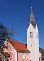
The branch church of St. Martin

Duck pond near Semerskirchen

Duck pond near Semerskirchen


Economy and Infrastructure
Economy including agriculture and forestry
According to official statistics, there were 14 employees at the place of work in the area of corporate service providers, 518 in the manufacturing sector and eight in the trade, transport and hospitality sectors. In other economic sectors, 485 people were employed at the place of work subject to social security contributions. There were a total of 1,025 employees at the place of residence subject to social security contributions. As of 2014, two companies were registered in the manufacturing sector and four companies in the construction sector. In addition, in 2010 there were 46 farms with an agriculturally used area of 1771 ha, of which 1660 ha were arable land and 108 ha were permanent green space.
The Herrngiersdorf Castle Brewery has existed since 1131 and is the oldest private brewery in the world.
The agricultural machinery manufacturer Ropa is by far the largest employer in the municipality.
education
There are the following institutions (status: 2014):
- Kindergartens: 35 kindergarten places with 39 children
- Elementary schools: one with four teachers and 66 students
Personalities
- Bernhard Lehner (1930–1944, “ Venerable Servant of God ”), whose beatification process began in 1951.
literature
- Wolf-Armin Freiherr von Reitzenstein : Lexicon of Bavarian place names. Origin and meaning. Upper Bavaria, Lower Bavaria, Upper Palatinate. CH Beck, Munich 2006, ISBN 3-406-55206-4 .
Individual evidence
- ↑ "Data 2" sheet, Statistical Report A1200C 202041 Population of the municipalities, districts and administrative districts 1st quarter 2020 (population based on the 2011 census) ( help ).
- ^ Wilhelm Volkert (ed.): Handbook of Bavarian offices, communities and courts 1799–1980 . CH Beck, Munich 1983, ISBN 3-406-09669-7 , p. 563 .
- ^ Federal Statistical Office (ed.): Historical municipality directory for the Federal Republic of Germany. Name, border and key number changes in municipalities, counties and administrative districts from May 27, 1970 to December 31, 1982 . W. Kohlhammer, Stuttgart / Mainz 1983, ISBN 3-17-003263-1 , p. 610 .
- ↑ a b Administrative community Langquaid: Municipal council election 2020, Herrngiersdorf municipality . Online at www.langquaid.de ; accessed on April 19, 2020.
- ↑ Administrative community Langquaid: Mayor election 2020 community Herrngiersdorf . Online at www.langquaid.de ; accessed on April 19, 2020.
- ↑ Administrative community Langquaid: Municipal council election 2020 - official final result . Online at www.langquaid.de ; accessed on April 19, 2020.
- ↑ Venerable Servant of God Bernhard Lehner from Herrngiersdorf (1930–1944) on Bistum-Regensburg.de , accessed on February 15, 2016
Web links
- Entry on the coat of arms of Herrngiersdorf in the database of the House of Bavarian History

Abensberg | Aiglsbach | Attenhofen | Bad Abbach | Biburg | Elsendorf | Essing | Hausen | Herrngiersdorf | Ihrlerstein | Kelheim | Kirchdorf | Langquaid | Mainburg | Neustadt an der Donau | Painten | Riedenburg | Rohr in Lower Bavaria | Hall on the Danube | Siegenburg | Teugn | Train | Volkenschwand | Wildenberg
Unregulated areas: Dürnbucher Forst | Frauenforst | Hacklberg | Hienheim Forest