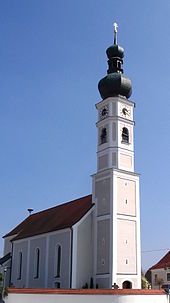
Elsendorf
| coat of arms | Germany map | |
|---|---|---|

|
Coordinates: 48 ° 42 ' N , 11 ° 49' E |
|
| Basic data | ||
| State : | Bavaria | |
| Administrative region : | Lower Bavaria | |
| County : | Kelheim | |
| Management Community : | Mainburg | |
| Height : | 405 m above sea level NHN | |
| Area : | 32.65 km 2 | |
| Residents: | 2163 (Dec. 31, 2019) | |
| Population density : | 66 inhabitants per km 2 | |
| Postal code : | 84094 | |
| Area code : | 08753 | |
| License plate : | KEH, MAY , PAR , RID, ROL | |
| Community key : | 09 2 73 163 | |
| Association administration address: | Regensburger Str. 1 84048 Mainburg |
|
| Website : | ||
| Mayor : | Markus Huber ( CSU ) | |
| Location of the municipality of Elsendorf in the Kelheim district | ||
Elsendorf is a municipality in the Lower Bavarian district of Kelheim .
geography
Elsendorf is located in the Landshut region in the Hallertau in the Abenstal.
The following districts exist : Appersdorf , Horneck, Mitterstetten, Ratzenhofen . Other districts are Allakofen, Margarethenthann, Haunsbach and Wolfshausen.
In addition, the following wastelands and hamlets belong to the municipality: Aichberg, Einthal, Emersdorf, Freudenthal, Gaden, Grubmühle , Hartlmühle, Landersdorf, Randlkofen and Weingarten.
history
Until the church is planted
Elsendorf was first mentioned in a document in 848. The next mentions are exactly 100 years later, i.e. in 948 as well as 972 and 981 as Elisindorf . The landlord Ulrich von Elsendorf transferred a farm in Elsendorf to the Benediktbeuern monastery in 1116 . However, only nine years later, in 1125, he bequeathed his property including the baptismal and parish church to the Admont Abbey in Styria , which was also looked after by the Benedictines , and entered there as a lay brother. This triggered a dispute between the monasteries of Benediktbeuern and Admont, since Benediktbeuern was awaiting a larger donation after leaving a single court. This conflict lasted until 1161. Later on, other founders also left their properties in Elsendorf to Admont Abbey. In 1171 it was finally confirmed in a papal bull that Elsendorf with its parish church St. Martin (today: parish church Maria Immaculata ) belongs to the Admont monastery. The monastery was much more committed to the farmers in the village than a secular landlord would have done. In 1637, five years after the devastating Swedish invasions for Elsendorf, Abbot Urban had "draft and milking cattle" bought in the Ennstal and distributed to the farmers in Elsendorf. In 1632 the Lords of Mamming, who resided at the nearby Ratzenhofen Castle, tried to buy the village, which had been ravaged by the Swedes, at a ridiculous price and, in particular, to acquire the right to present the parish. The Elsendorf provost's office was not sold until 1668, albeit to the Hohenwart monastery , which at the time was run by Benedictine nuns. In 1735 the Lords of Mamming tried again to obtain the right to present Elsendorf; however, this attempt was also in vain. In 1775 this right was finally acquired by Wiguläus Freiherr von Kreittmayr, who owned, among other things, Offenstetten Castle . Despite secularization, the Kreittmayr family exercised the right to present Elsendorf until 1879, after which it was exercised by the respective owners of Offenstetten Castle until 1943 (!).
In the course of the administrative reforms in Bavaria, the municipality of Ratzenhofen came into being with the municipal edict of 1818. This was also assigned to Elsendorf.
Incorporations
On January 1, 1972, the previously independent municipality of Appersdorf was incorporated into the municipality of Ratzenhofen. Mitterstetten was added on January 1, 1978. The municipality of Elsendorf only got its name in 1985 when the previous municipality of Ratzenhofen was renamed.
Population development
In the period from 1988 to 2018, the population increased from 1,672 to 2,147 by 475 inhabitants or by 28.4%.
- 1961: 1555 inhabitants
- 1970: 1577 inhabitants
- 1987: 1616 inhabitants
- 1991: 1746 inhabitants
- 1995: 1815 inhabitants
- 2000: 1935 inhabitants
- 2005: 2028 inhabitants
- 2010: 2039 inhabitants
- 2015: 2138 inhabitants
politics
The community is a member of the Mainburg administrative community . The first mayor is Markus Huber (CSU).
coat of arms
| Blazon : “Split; in front again split by silver and red with two vertical diamonds in mixed up colors; Divided at the back, divided at the top by black and gold with a floating St. Andrew's cross in mixed up colors, at the bottom in black a growing, fire-breathing, black-spotted golden tiger. " | |
Architectural monuments
Economy and Infrastructure
Economy including agriculture and forestry
In 1998, according to official statistics, there were eight in the field of agriculture and forestry, 233 in the manufacturing sector and 27 in the trade and transport sector at the place of work. In other economic areas, 60 people were employed at the place of work subject to social security contributions. There were a total of 602 employees at the place of residence subject to social security contributions. There were no companies in the manufacturing sector and five in the construction sector. In addition, in 1999 there were 100 farms with an agriculturally used area of 1881 ha, of which 1669 ha were arable land and 189 ha were permanent green space. Hop growing plays an important role.
The Horneck brewery , which also runs a restaurant and farm, is located in the district of the same name.
education
In 1999 the following institutions existed:
- Kindergartens: 75 kindergarten places with 83 children
- Elementary schools: a primary school with nine teachers and 158 students
Born in Elsendorf
- Vinzenz Schöttl (1905–1946), SS leader in a leading position in concentration camps and mass murderer, born in Appersdorf
Web links
Individual evidence
- ↑ "Data 2" sheet, Statistical Report A1200C 202041 Population of the municipalities, districts and administrative districts 1st quarter 2020 (population based on the 2011 census) ( help ).
- ^ Municipal organs 2014 - 2020. Elsendorf municipality, accessed on June 16, 2020 .
- ^ Sixtus Lampl : Elsendorf - Parish Church of the Immaculate Conception . Schlossverlag Valley, 200, ISBN 3-406-09669-7 , p. 3–9, p. 26 .
- ^ Wilhelm Volkert (ed.): Handbook of Bavarian offices, communities and courts 1799–1980 . CH Beck, Munich 1983, ISBN 3-406-09669-7 , p. 516 .
- ^ Federal Statistical Office (ed.): Historical municipality directory for the Federal Republic of Germany. Name, border and key number changes in municipalities, counties and administrative districts from May 27, 1970 to December 31, 1982 . W. Kohlhammer, Stuttgart / Mainz 1983, ISBN 3-17-003263-1 , p. 611 .
- ↑ Bavarian State Office for Statistics and Data Processing (Hrsg.): The municipalities of Bavaria according to the territorial status May 25, 1987. The population of the municipalities of Bavaria and the changes in the acquisitions and territory from 1840 to 1987 (= contributions to Statistics Bavaria . Issue 451). Munich 1991, p. 25 , urn : nbn: de: bvb: 12-bsb00070717-7 ( digitized version ).
- ^ Entry on the coat of arms of Elsendorf in the database of the House of Bavarian History


