Sandsbach
|
Sandsbach
Herrngiersdorf municipality
Coordinates: 48 ° 48 ′ 23 " N , 12 ° 3 ′ 4" E
|
||
|---|---|---|
| Height : | 397 m above sea level NN | |
| Residents : | 464 (2012) | |
| Incorporation : | May 1, 1978 | |
| Area code : | 84097 | |
|
Location of Sandsbach in Bavaria |
||
|
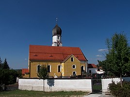
Parish Church of St. Peter
|
||
Sandsbach is a part of the municipality Herrngiersdorf in the district of Kelheim in Bavaria . The parish village was the seat of an independent community until 1978 .
geography
Sandsbach lies between Landshut and Regensburg at an altitude of 397 m above sea level. NN and has 464 inhabitants (as of 2012). The place is located on a gentle slope on the east side of the Great Labertal , about two kilometers south of the Langquaid market . The state road in 2143 , the long Quaid with Rottenburg an der Laaber combines, about one kilometer west of the town center leads over. The federal highway 93 and the highway-like expanded highway 15n can be reached from Sandsbach in just a few minutes.
history
The first documentary mention in the form of Samutespach comes from the year 878. After that, King Karlmann gave his priest Job de Samotespah "two hooves with eight servants for life". After Job's death, the possessions were to fall to the Sankt Emmeram monastery in Regensburg . The document, executed by the clerk Baldo, is written in Latin and bears the signature of King Karlmann, a great-grandson of Emperor Charlemagne . Sandsbach was subordinate to the Geisenfeld monastery from 1043 to 1803 as provost and court marque .
The municipality of Sandsbach, founded in 1818 with the Bavarian municipal edict, with the suburbs of Sandsbach, Appersdorf, Siegersdorf and Langquaid (municipality of Sandsbach) was dissolved on January 1, 1978. The larger part came to Herrngiersdorf, the smaller part to Langquaid market .
Attractions
Individual evidence
- ↑ Müller's Grosses Deutsches Ortsbuch 2012. , De Gruyter, 2012, p. 1201.
- ^ Federal Statistical Office (ed.): Historical municipality directory for the Federal Republic of Germany. Name, border and key number changes in municipalities, counties and administrative districts from May 27, 1970 to December 31, 1982 . W. Kohlhammer GmbH, Stuttgart and Mainz 1983, ISBN 3-17-003263-1 , p. 611 .


