
Hostage wind
| coat of arms | Germany map | |
|---|---|---|

|
Coordinates: 49 ° 46 ' N , 10 ° 28' E |
|
| Basic data | ||
| State : | Bavaria | |
| Administrative region : | Lower Franconia | |
| County : | Kitzingen | |
| Height : | 345 m above sea level NHN | |
| Area : | 48.77 km 2 | |
| Residents: | 2501 (Dec. 31, 2019) | |
| Population density : | 51 inhabitants per km 2 | |
| Postal code : | 96160 | |
| Primaries : | 09556, 09555 | |
| License plate : | KT | |
| Community key : | 09 6 75 127 | |
| LOCODE : | DE GQD | |
| Market structure: | 24 districts | |
Market administration address : |
Marktplatz 1 96160 Geiselwind |
|
| Website : | ||
| Mayor : | Ernst Nickel (FW / Landgemeinschaft) | |
| Location of the Geiselwind market in the Kitzingen district | ||
  |
||

Geiselwind is a market in the Lower Franconian district of Kitzingen . The place is best known for the Freizeit-Land Geiselwind adventure park .
geography

Geographical location
The place is east of Würzburg . On the edge of the municipality is the Dreifrankenstein , where the three Franconian administrative districts of Lower Franconia , Middle Franconia and Upper Franconia meet.
The core town of Geiselwind is located in the Steigerwald slightly above the confluence of the Ebrach (also called Geiselwinder Ebrach ) into the Ebrach realm .
Community structure
The municipality has 24 districts:
|
The municipalities also include the districts of Burggrub, Dürrnbuch, Ebersbrunn, Füttersee, Geiselwind, Gräfenneuses, Haag, Holzberndorf, Ilmenau, Langenberg, Rehweiler and Wasserberndorf.
Neighboring communities
Neighboring communities are (starting from the north clockwise) Ebrach , Schlüsselfeld , Burghaslach , Oberscheinfeld , Castell , Abtswind , Wiesentheid , Prichsenstadt and Oberschwarzach .
Protected areas
The place is in the middle of the Steigerwald Nature Park . Only a narrow strip along the federal highway 3 and the state road 2260 is not placed under special protection. In addition, large parts are protected as a landscape conservation area . Areas of geological interest have been declared geotopes. There is an extensive dune field northwest of the main town and the so-called dune field northeast of Gräfenneuses near Gräfenneuses .
In addition, several special objects have been preserved that are classified as natural monuments . Around Ebersbrunn there are four old trees that characterize the landscape, a red beech, an oak and two wooden pear trees. The imperial oak near Füttersee is one of the oldest solitary trees in Germany. An oak near Ilmenau characterizes the area around the village. The village of Neugrub in the east of the village is also classified as a natural monument.
history
Surname
The name Geiselwind suggests that it was founded in the 8th century. At that time, Wends were settled in the Franconian area by decree of the German Emperor . It is disputed whether this Wendensiedlung got its name from an imperial daughter Gisela, who lived in a nearby monastery, or from an imperial vassal named Giso.
Until the church is planted
Geiselwind appears late in the documented sources. In 1316 a certain Heinrich, called Frevel, feudal man of the Counts of Castell , left his goods in Geiselwind to the Ebrach Monastery , whereby Count Friedrich zu Castell renounced his feudal rights. By the end of the 14th century at the latest, the Zollner zu Hallburg and Rimbach owned "the village of Geiselwind" as a castellan fief. They sold it to the castle counts court master Wirich von Treuchtlingen . It was thanks to this change of ownership that Geiselwind received market rights and its own central court in 1422 from the Roman-German King Sigismund . In 1426 the Castell'sche fiefdom Geiselwind passed to the Fürstete Grafschaft Schwarzenberg. The princes of Schwarzenberg took over the church patronage from the Augustinian canons of Birklingen in 1503 and introduced the Reformation in Geiselwind . The place remained Protestant until 1627.
With the Rheinbund act 1806 the place came to Bavaria. In the course of the administrative reforms in the Kingdom of Bavaria , today's municipality was created with the municipal edict of 1818 .
Administrative affiliation
Until the district reform , which came into force on July 1, 1972, Geiselwind belonged to the Scheinfeld district and thus to Middle Franconia .
Desolations and incorporations

In the east of the village lies the Weingarten desert . The village was probably abandoned in the 16th century. The Untere Weingartsmühle was one of the remains of the village until the 18th century, before it was also given up. The former brickworks of the place, which disappeared in the 1950s, can also be classified as a desert .
On January 1, 1972, the previously independent communities of Füttersee, Gräfenneuses, Haag (until 1866 with the community name Dürrenbach ), Langenberg and Wasserberndorf and parts of the dissolved community of Freihaslach were incorporated. On July 1, 1972, Ebersbrunn and Rehweiler were added from the dissolved district of Gerolzhofen . Ilmenau followed on January 1, 1978. Holzberndorf was added on May 1, 1978.
Population development
| year | 1961 | 1970 | 1987 | 1991 | 1995 | 2000 | 2005 | 2010 | 2015 |
| Residents | 2015 | 2125 | 2016 | 2182 | 2272 | 2323 | 2417 | 2380 | 2416 |
Say
The Murrmann

The best-known legend of Geiselwind is about Murrmann, the story of a siege of Geiselwind during the Thirty Years' War .
The mayor of Geiselwind wanted to prevent the seizure and looting of the place and went with two of his confidants to the camp of the enemy army to negotiate with the Swedish general. The latter was just about to start lunch and, perhaps because of this disturbance, was very angry, not thinking about negotiations. Angrily, he grabbed a sausage that he was about to eat, held it out to the negotiators and shouted: "As much as I eat this sausage here: I will take hostage wind!"
At that moment a black cat jumped on the general's shoulder, knocked the sausage out of his hand, grabbed it and ran away with the sausage in its mouth.
According to legend, Geiselwind was not taken during this siege. Depending on the version, this was due to the fact that the hostage-winders drew new courage with this sign and fended off the siege, that the Swedes saw the events as a bad omen and moved quickly on or that the Swedish general did not say anything untrue, but rather wanted to keep his word and therefore ended the siege.
There is still a sandstone figure at the western end of the market square that depicts Murrmann . The figure, with a cat sitting on its shoulder, is holding up a sausage with its outstretched arm.
The former size
Similar to Hellmitzheim near Iphofen, there is also a legend in Geiselwind about the former size of the settlement.
The population of Geiselwind spoke for a long time that the place should have been a lot bigger in the past. At that time, the community extended to today's Weingartsmühle and held city rights. The legend probably alludes to the former Weingarten settlement, which was originally located east of Geiselwind and was abandoned in the 15th century.
politics

Municipal council
In the municipal council election on March 16, 2014 , the 14 councilors were newly elected with a turnout of 62.6%. They were all on the joint list of CSU / FW / G18 for election. Two of the elected are women.
mayor
Mayor is Ernst Nickel ( Free Voters / Landgemeinschaft). On May 1, 2002, he succeeded Gottfried Schaller (Free Voters / Landgemeinschaft). In the 2014 local elections, he was re-elected with 76.0% of the valid votes and on March 15, 2020 with 80.0% of the votes for a further six years.
coat of arms

|
|
Blazon : “Divided by blue and silver; above a slanting golden flagellum, below on the green ground a jumping, red-tongued black greyhound with a gold collar. " |
|
Justification for the coat of arms: The coat of arms appears for the first time on a market seal imprint from 1713. The coat of arms colors have been known since 1835. The scourge and the greyhound speak for the place name, the original meaning of which was no longer understood. It is translated as "to the Slavic settlers of Gisilo". The settlement dates back to the 8th to 10th centuries. The place is first mentioned in documents in 1199. The colors silver and blue are taken from the coat of arms of the princes of Schwarzenfeld, who ruled the community. At the beginning of the 19th century, the scourge was replaced by a bush and the green soil was missing. The coat of arms does not appear in the 19th and early 20th centuries and Hupp does not have it in his coat of arms collection either.
The coat of arms has been used since the 18th century. |
Culture and sights
- Town hall in Geiselwind, representative administrative seat with half-timbered houses on the market square
- St. Burkard in Geiselwind, Catholic parish church
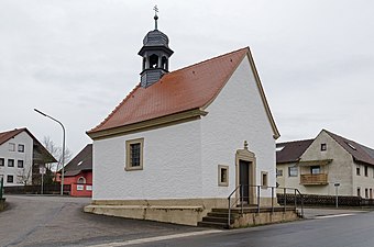
- Trinity Chapel and Marienkapelle , two small churches, both donated by two brothers in 1723 and built on the outskirts of Geiselwind
- Evangelical Church in Rehweiler, the only Moravian hall church in Bavaria
- Michaelskirche in Hohnsberg. Small village church with a 15th century choir tower
- Imperial oak near Füttersee
- The funeral hall at the cemetery in Geiselwind, redesigned in 2006 by installing three bronze relief panels by master stonemason and stone sculptor Andreas Fenn from Marktbreit on behalf of the Reinleins Kreuzweg Foundation
- Attractions

Parish Church of St. Burkard

Protestant Church Rehweiler
Geiselwind, Marienkapelle

Imperial feeding lake


Architectural monuments
Economy and Infrastructure
economy

Until the 20th century, only agriculture and forestry were important in Geiselwind. That changed in the mid-1960s with the construction of the federal motorway 3 , to which Geiselwind is connected with its own exit.
In 2014, the municipal tax revenue was 1,667,000 euros, of which 503,000 euros (net) were trade tax revenue.
In 2014 there were no employees at the place of work in agriculture and forestry, 126 in manufacturing and 372 in trade, transport, and hospitality. In other areas of the economy 150 people were employed at the place of work subject to social security contributions. There were a total of 1,048 employees at the place of residence subject to social security contributions. There was one company in manufacturing and six in construction. In the year 2010
there were also 68 farms with an agricultural area totaling 2046 hectares. Of this, 1,264 hectares were arable land and 777 hectares were permanent green areas.
The largest employers are:
- Leisure country Geiselwind
- Strohofer truck stop
- Pure parquet
education
In 2015 the following institutions existed:
- Two kindergartens: 98 kindergarten places with 78 children
- a primary and secondary school with 6 teachers and 82 students
Personalities
- Hans Herold (* 1955), politician, member of the Bavarian State Parliament
- Dieter Hoffmann (* 1934), writer, lives in Geiselwind
- Alois Josef Ruckert (1846–1916), teacher and writer, spent the last years of his life in Geiselwind
literature
- Hans Bauer: District of Kitzingen. An art and culture guide . Market wide 1993.
- Johann Kaspar Bundschuh : Geiselwind . In: Geographical Statistical-Topographical Lexicon of Franconia . tape 2 : El-H . Verlag der Stettinische Buchhandlung, Ulm 1800, DNB 790364298 , OCLC 833753081 , Sp. 290 ( digitized version ).
- Johann Ludwig Klarmann, Karl Spiegel: Legends and sketches from the Steigerwald. Reprint of the 1912 edition . Neustadt an der Aisch 1982.
- Erwin Müller: Geiselwind in the middle of Franconia. With landscape studies and history . Scheinfeld 2001.
- Wolf Dieter Ortmann: District of Scheinfeld (= historical place name book of Bavaria. Middle Franconia, vol. 3) . Munich 1967. Local name part .
- Pleikard Joseph Stumpf : hostage wind . In: Bavaria: a geographical-statistical-historical handbook of the kingdom; for the Bavarian people . Second part. Munich 1853, p. 758 ( digitized version ).
Web links
Individual evidence
- ↑ "Data 2" sheet, Statistical Report A1200C 202041 Population of the municipalities, districts and administrative districts 1st quarter 2020 (population based on the 2011 census) ( help ).
- ↑ Markt Geiselwind in the local database of the Bayerische Landesbibliothek Online . Bavarian State Library, accessed on September 15, 2017.
- ^ Wilhelm Volkert (ed.): Handbook of Bavarian offices, communities and courts 1799–1980 . CH Beck, Munich 1983, ISBN 3-406-09669-7 , p. 565 .
- ↑ a b c Federal Statistical Office (ed.): Historical municipality directory for the Federal Republic of Germany. Name, border and key number changes in municipalities, counties and administrative districts from May 27, 1970 to December 31, 1982 . W. Kohlhammer GmbH, Stuttgart / Mainz 1983, ISBN 3-17-003263-1 , p. 747 and 748 .
- ↑ Murrmannsage on wurstakademie.com
- ↑ Klarmann, Johann Ludwig (among others): Legends and sketches from the Steigerwald . P. 108.
- ^ Bavarian State Office for Statistics , accessed on November 29, 2017
- ↑ Mayor. Geiselwind community, accessed on July 18, 2020 .
- ^ Entry on the Geiselwind coat of arms in the database of the House of Bavarian History

Cities: Dettelbach | Iphofen | Kitzingen | Mainbernheim | Market wide | Marktsteft | Prichsenstadt | Volkach
Markets: Abtswind | Hostage wind | Großlangheim | Kleinlangheim | Einersheim Market | Obernbreit | Rüdenhausen | Schwarzach am Main | Home of being | Wiesentheid | Willanzheim
Municipalities: Albertshofen | Biebelried | Buchbrunn | Castell | Mainstockheim | Martinsheim | Nordheim am Main | Rödelsee | Segnitz | Sommerach | Sulzfeld am Main | Wiesenbronn
Burggrub | Dürrnbuch | Ebersbrunn | Feeding lake | Hostage wind | Gräfenneuses | Hague | Hohnsberg | Holzberndorf | Dog ranks | Hutzelmühle | Ilmenau | Langenberg | New pit | Rehweiler | Röhrensee | Grinding mill | Schnackenmühle | Seeramsmühle | Sixtenberg | Theuerleinsmühle | Bird's rest | Wasserberndorf | Weingartsmühle