
Albertshofen
| coat of arms | Germany map | |
|---|---|---|

|
Coordinates: 49 ° 46 ' N , 10 ° 10' E |
|
| Basic data | ||
| State : | Bavaria | |
| Administrative region : | Lower Franconia | |
| County : | Kitzingen | |
| Management Community : | Kitzingen | |
| Height : | 187 m above sea level NHN | |
| Area : | 3.8 km 2 | |
| Residents: | 2286 (Dec. 31, 2019) | |
| Population density : | 602 inhabitants per km 2 | |
| Postal code : | 97320 | |
| Area code : | 09321 | |
| License plate : | KT | |
| Community key : | 09 6 75 112 | |
| Community structure: | 1 district | |
| Association administration address: | Friedrich-Ebert-Str. 5 97318 Kitzingen |
|
| Website : | ||
| Mayor : | Horst Reuther ( CSU ) | |
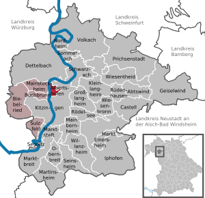
| Location of the community of Albertshofen in the district of Kitzingen | ||
  |
||


Albertshofen is a municipality in the Lower Franconian district of Kitzingen and a member of the Kitzingen administrative community .
geography
Geographical location
The community is located on the Main and is connected to the neighboring community of Mainstockheim by a ferry .
Neighboring communities
Neighboring communities are (clockwise from the south): Kitzingen , Mainstockheim , Mainsondheim and Dettelbach .
Natural location
Albertshofen and its district is located in two natural areas. The east with the extensive arable land is part of the Albertshofener drifting sand area , while the Kitzinger Main Valley begins in the west on the Main, which is much less precipitated .
Protected areas
The Main, which runs to the west of Albertshofen, is protected by the nature conservation authorities as a fauna and flora habitat “Mainaue between Grafenrheinfeld and Kitzingen”. In the east, but not in the local area, is the so-called monastery forest as a bird sanctuary in the southern Steigerwald foreland . A natural monument , the old village linden tree in front of the Reuss estate in the center of the village has no longer been preserved.
history
Albertshofen was first mentioned in 1317 when Gottfried von Hohenlohe gave a fief to Otto Fuchs and his brother Konrad.
The place used to be divided into two parts. The smaller Unterdorf belonged to the Kitzinger Spital. Owners of the larger upper village were the respective castle owners of Mainsondheim , until 1592 the lords of Crailsheim , until 1727 the family Fuchs von Dornheim and since 1727 the barons of Mauchenheim, called Bechtolsheim .
The office of the Hochstift Würzburg / Spital Kitzingen fell to Bavaria in 1803 ( Reichsdeputationshauptschluss ) and had to be left to Archduke Ferdinand of Tuscany to form the Grand Duchy of Würzburg in the Peace of Pressburg in 1805 . The local estates of the Barons von Bechtolsheim were mediatized in 1806. In the course of the administrative reforms in the Kingdom of Bavaria , today's municipality was created with the municipal edict of 1818 .
The place developed in the 19th century from a wine-growing community to fruit growing and becoming an important vegetable growing area. A few years ago, viticulture was revived with 16 hectares of Albertshöfer Herrgottsweg.
In 1996, Bavaria's first referendum was held in Albertshofen. The topic was the planned construction of a bridge to Mainstockheim. This construction project was finally rejected with a majority of 10 votes.
politics
mayor
Horst Reuther has been CSU mayor since May 1st, 2008 ; he was elected for a further six years in 2014 and (with 62.0%) on March 15, 2020.
coat of arms
|
|
Blazon : “By a slanted silver wavy bar divided by black and red; in front two silver bars, behind three one-to-two silver balls. " |
| Justification of the coat of arms: In the coat of arms of the municipality, first mentioned in a document in 1317, the three silver spheres indicate Saint Nicholas. They are his hallmarks. The Alberthofen church is dedicated to him. The place was divided in the Middle Ages. The Kitzinger Spital ruled the smaller district. The greater part was subordinate to the respective castle owners. From 1727 these were the barons of Meuchenheim called Bechtoldsheim. Your family coat of arms are two silver bars in a black field. These attributes were adopted in today's coat of arms. The location of the municipality on the Main is shown by the silver wave bar. Silver and red, the colors in the coat of arms, are the colors of Franconia . The coat of arms was awarded by the Ministry of the Interior on January 30, 1969. |
banner
The Albertshofen community has its own flag . It is kept in the colors red and white.
Attractions

The place is connected to the neighboring community of Mainstockheim by a Main ferry . This crossing of the Main is particularly popular with pedestrians and cyclists. However, it is also approved for cars, trucks and agricultural tractors. The Protestant parish church forms the center of the village. It was created in its current form in the 17th century.
The highlight of village life in November is the well-known Höpper Kerm with the traditional Wasenziehen and Göikerschlag.
The place has the largest contiguous field irrigation system on 380 hectares in Bavaria. The water for this, like the drinking water supply, is not promoted and provided by the municipality itself, but by the water procurement association . This public corporation also settles accounts with users and households and ensures constant water quality.
An annual wine festival has been held at the end of August since 1986.
Architectural monuments
Soil monuments
economy
In 1998 there were 76 employees in the field of agriculture and forestry, 67 in the manufacturing sector and 85 in trade and transport at the place of work. In other economic sectors 74 people were employed at the place of work subject to social security contributions. 822 were employed at the place of residence subject to social security contributions. There was one company in the manufacturing industry, including mining and the extraction of stones and earth, and six companies in the main construction industry. In 1999 there were 48 farms with an agricultural area of 305 hectares. 284 hectares of which were arable land. Albertshofen is one of the most important vegetable growing areas in Bavaria. There is also the Herrgottsweg vineyard. Most of the vegetables are marketed by the Main-Danube Horticultural Center.
Viticulture
Today Albertshofen is a wine-growing area in the Franconian wine-growing region . There is a vineyard around the village, the wine has been marketed under the name Albertshöfer Herrgottsweg since the 1970s. Albertshofen is part of the region Main south until 2017, the wineries in area were Maindreieck summarized. The shell limestone soils with a layer of river sand around Albertshofen are just as suitable for growing wine as the location in the Maingau climate zone, which is one of the warmest in Germany.
The people around Albertshofen have been growing wine since the early Middle Ages . The Franconian settlers probably brought the vine to the Main in the 7th century. In the Middle Ages, the region was part of the largest contiguous wine-growing region in the Holy Roman Empire. The people mostly operated part-time viticulture for self-sufficiency , at the same time export centers were already emerging, especially along the Main. Albertshofen remained a pure wine-growing community until the 19th century.
Viticulture experienced a major decline after secularization at the beginning of the 19th century. Above all, locations with less favorable climatic conditions were completely abandoned. In addition, the emergence of pests such as phylloxera made cultivation difficult . In Albertshofen, vegetables were grown and viticulture lost its dominant economic position. The Franconian wine-growing region was not able to consolidate again until the second half of the 20th century. The use of fertilizers and improved cultivation methods had contributed to this, as had the organization in cooperatives and the land consolidation of the 1970s.
The centuries-old wine culture of the village is now represented by several wineries in the village. The focus of the festival calendar is the Albertshöfer Wine Festival , which takes place every year at the beginning of August. A wine princess has been elected in Albertshofen to present the local wine since the 1980s.
| Vineyard | Size 1993 | Size 2019 | Compass direction | Slope | Main grape varieties | Great location |
|---|---|---|---|---|---|---|
| Herrgottsweg | 15 ha | 18 ha | southwest | 10-15% | Müller-Thurgau , Silvaner , Bacchus | Kitzinger Councilor |
Personalities
- Heinrich Christian Beck (1805–1866), pastor, local historian and naturalist
- Bernhard Bauknecht (1900–1985), politician ( CDU ) and peasant functionary
literature
- Hans Ambrosi , Bernhard Breuer: German Vinothek: Franconia. Guide to the vineyards, winegrowers and their kitchens . Herford² 1993.
Web links
- Homepage
- Entry on the coat of arms of Albertshofen in the database of the House of Bavarian History
Individual evidence
- ↑ "Data 2" sheet, Statistical Report A1200C 202041 Population of the municipalities, districts and administrative districts 1st quarter 2020 (population based on the 2011 census) ( help ).
- ^ Albertshofen community: Mayor's office. Retrieved May 9, 2020 .
- ^ House of Bavarian History: Albertshofen coat of arms , accessed on July 1, 2019.
- ^ Ambrosi, Hans (among others): German Vinothek: Franconia . Pp. 50-52.
- ^ Weinfest-Albertshofen: Wine Festival , accessed on May 28, 2019.
- ^ Government of Lower Franconia: Vineyards in Bavaria broken down by area , PDF file, accessed on May 16, 2019.
- ^ Ambrosi, Hans (among others): German Vinothek: Franconia . P. 237.

Cities: Dettelbach | Iphofen | Kitzingen | Mainbernheim | Market wide | Marktsteft | Prichsenstadt | Volkach
Markets: Abtswind | Hostage wind | Großlangheim | Kleinlangheim | Einersheim Market | Obernbreit | Rüdenhausen | Schwarzach am Main | Home of being | Wiesentheid | Willanzheim
Municipalities: Albertshofen | Biebelried | Buchbrunn | Castell | Mainstockheim | Martinsheim | Nordheim am Main | Rödelsee | Segnitz | Sommerach | Sulzfeld am Main | Wiesenbronn