
Marktsteft
| coat of arms | Germany map | |
|---|---|---|

|
Coordinates: 49 ° 42 ' N , 10 ° 8' E |
|
| Basic data | ||
| State : | Bavaria | |
| Administrative region : | Lower Franconia | |
| County : | Kitzingen | |
| Management Community : | Market wide | |
| Height : | 189 m above sea level NHN | |
| Area : | 10.52 km 2 | |
| Residents: | 1993 (Dec. 31, 2019) | |
| Population density : | 190 inhabitants per km 2 | |
| Postal code : | 97342 | |
| Area code : | 09332 | |
| License plate : | KT | |
| Community key : | 09 6 75 149 | |
| City structure: | 3 districts | |
City administration address : |
Main street 27 97342 Marktsteft |
|
| Website : | ||
| Mayor : | Thomas Reichert ( CSU ) | |
| Location of the town of Marktsteft in the Kitzingen district | ||
  |
||

Marktsteft is a town in the Lower Franconian district of Kitzingen and a member of the Marktbreit administrative association .
geography
Neighboring communities
Kitzingen , Mainbernheim , Willanzheim , Seinsheim , Obernbreit , Marktbreit , Segnitz and Sulzfeld am Main . The largest city in the area is Würzburg 17 km northwest.
City structure
Marktsteft consists of three districts:
- Marktsteft
- Michelfeld
- Wasenmeisterei
Natural location

Marktsteft and its district are located in two natural areas, both of which are part of the main unit group Mainfränkische Platten . The place itself can be located in the low-precipitation Kitzinger Main Valley , the district protrudes into the higher, flat, undulating Mainbernheim Plain . The Michelfeld district can also be found here.
climate
The Main Triangle is one of the warmest and driest regions in Franconia . This climate is particularly favorable for the cultivation of wine , fruit and vegetables. The annual average temperature is around 8 ° C.
history

Place name
The place was called 1216 Stephe . The name of the church patron Stephanus was included in the name of the settlement. Later forms of the name were:
|
|
|
|
|
The supplement market designates the legal status to hold markets.
Local history
The first documentary mention of a bailiwick in Marktsteft was in 1197. The place was named "Stephe" in 1216 and "Stepfe das dorff" in 1371 owned by the Counts of Hohenlohe-Brauneck. In 1399 the Counts of Castell had the right of patronage over the "parish of Stefft".
In 1448, Margrave Albrecht Achilles von Brandenburg-Ansbach acquired the following six main villages from the previous owners : Obernbreit , Gnodstadt , Marktsteft, Sickershausen , Martinsheim and Oberickelsheim . This property gave the margraves access to the Main.
In the period from 1448 to 1791, Marktsteft remained under this margrave rule. Already in 1532 the place had a fortified church , which offered refuge in times of war. The Reformation was introduced in 1534.
In 1629, the Würzburg bishopric replaced rule over the city of Kitzingen from the property of the margrave. As a result, the margrave lost the bridgehead and the harbor area on the Main, which he had owned since 1443. The small village of Marktsteft am Main offered itself as a replacement.
Steft was raised to market on November 4, 1729 by Margravine Christina Charlotta. The market survey certificate conferred a number of privileges:
- Ten-year tax exemption for artists, merchants, traders and craftsmen who settle here
- Five-year beverage tax reduction for innkeepers by half
- Ten-year tax exemption for builders of two-story houses
- Five-year tax exemption for builders of one-story houses
- For four years 50% tariff discount for cargo handling in Marktsteft
- Five years of tax and duty exemption for goods manufactured there
- Introduction of a weekly market
- Holding a fair on Whit Monday and Mattheitag
- Five-year duty exemption for all goods brought to the markets
- Three-year exemption from customs duties for Jews who visit the annual markets
Already on November 30, 1712, these market privileges were opened in the town hall. They formed the prerequisite for numerous worldwide trade relations. With support from Ansbach, 91 new buildings were built in Marktsteft. The population experienced an economic boom through the targeted settlement of businesses and the expansion of the port. Under Prussian rule, the place increasingly lost its importance.
In the Treaty of Paris (February 1806), Marktsteft was exchanged with the Principality of Ansbach, which had become Prussian in 1792, to the Kingdom of Bavaria . In the course of the administrative reforms in Bavaria, today's municipality was created with the municipal edict of 1818 . In 1819 Marktsteft was promoted to town.
Catholics have been living in the village again since the 19th century; with the Church of the Resurrection, which was completed in 1964, they received their own house of worship.
port
After the loss of Kitzingen, the Margrave of Ansbach had the engineer-lieutenant and surveyor Johann Georg Vetter draw up a plan of the planned new port on the Main.
The natural mooring on the Mainarm was expanded as a port facility in 1729. The port attracted entrepreneurs such as B. the hosiery . They set up their workshops there from 1731. The houses were in Strumpfverbindergasse. In the years 1777 to 1782 over a thousand mercenaries of the Ansbach margrave were shipped there for the American War of Independence . Almost a fifth of those fell in combat, a third remained in the United States as immigrants, and just over half came back. In 1788, more than 1,400 rented soldiers set out from Stefter Hafen again. This time they were in the service of the Dutch against Napoleon's troops . A debt was not paid off thereby; Margrave Karl Alexander then ceded his margraviate to Prussia for an annuity and the Marktstefter port had become the only Prussian port on Bavarian territory. During the Napoleonic War , goods from England intended for the Near and Far East came to Marktstefter Hafen via the Rhine and Main. From there it was transported overland with horse-drawn vehicles via Nuremberg to the Danube. After the construction of the railway line in the Würzburger Land, the Stefter harbor lost its importance.
Incorporations
On May 1, 1978, the previously independent municipality Michelfeld was incorporated into the town of Marktsteft.
Population development
| year | 1834 | 1865 | 1868 | 1900 | 1925 | 1950 | 1961 | 1970 | 1991 | 1995 | 2005 | 2010 | 2015 |
|---|---|---|---|---|---|---|---|---|---|---|---|---|---|
| Residents | 1215 | 1172 | 1215 | 1309 | 1243 | 1805 | 1561 | 1597 | 1659 | 1658 | 1764 | 1787 | 1939 |
Source of the figures without individual reference: Bavarian State Office for Statistics and Data Processing
politics
mayor
Thomas Reichert has been mayor since May 1, 2014; he was elected for a further six years on March 15, 2020 with 54.2% of the vote.
City council
The city council has twelve members. The composition for the terms of office 2014 to 2020 and 2020 to 2026 is as follows:
| Party / list | Seats from 2014 | Share 2014 |
Seats from 2020 | Share 2020 |
| CSU | 3 | 22.0% | 3 | 27.8% |
| Free community of voters | 4th | 36.9% | 4th | 29.7% |
| Free voter group Michelfeld | 2 | 18.6% | 2 | 19.9% |
| Social civic bloc | 3 | 22.5% | 3 | 22.6% |
coat of arms
|
|
Blazon : "In gold, the silver nimbly Saint Stephen growing in a blue robe, the green martyr's palm in his right hand, three golden stones in the thrown in his left hand." |
| Justification of the coat of arms: Saint Stephen was first depicted on a seal from 1578. The figure rose to the coat of arms with the town elevation in 1819. The saint is the patron saint of Marktsteft. |
In addition to the coat of arms of the main town, which is also the municipal coat of arms today, there is also the coat of arms of the Michelfeld district, which was officially used until its incorporation in 1978. → see also: Michelfeld coat of arms
Culture and sights
Museums
- City and Family History Museum
Buildings
Architectural monuments

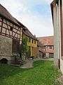
Historic port facility
Keerlhaus with risalit and balcony

Red Keerlhaus
Arcade with free-standing pulpit

The cemetery pulpit of the Marktstefter cemetery


Historic port facility
The historic port facility is the oldest in its original form in Bavaria and is maintained today by the port and cultural association. Traces of the crane built in 1764 can still be seen.
Keerlhäuser
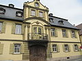
In 1688 what was originally the only inn to the three golden crowns in the Maindorf Steft was rebuilt by Sebastian Keerl. The margrave found quarters there with his retinue. The wealth of the Keerl merchant family is still visible today: It is evident in the Keerlhaus from 1774, a two-story residential building with a mansard roof . The rococo facade is interrupted in the middle by a risalit with a wrought-iron balcony and volute gable . Opposite is the Rote Keerlhaus with a rococo pavilion in the garden.
Fortified church with St. Stephan
During the time of Christianization, the landlord created settlements and founded churches such as St. Stephan in Marktsteft. It belonged to the own churches of the Casteller counts . As feudal lords they equipped their own churches, ensured their preservation and appointed the clergy. They protected, monitored and ordered the ministry of the pastors. The stone altar anchored in the ground with the relics formed the center of the own church . The church grounds were surrounded by the churchyard with the graves. This also included the "rectory with farm buildings and land, parish and hat law, parish and church income, tithes and pride fees ". Today's church building is still surrounded by remains of the former fortified church . The town hall is located in the gate tower and in the adjacent building. The oldest part of St. Stephan is the four-story tower. It was completed in 1608. The sources of 1565 tell of a previous building in connection with the weather ringing and a Hosanna bell. The nave was built in the years 1623-1624. The first year is recorded on the choir arch and the second on the northern entrance. The building was heavily modified several times by numerous repair and renovation works in 1737, 1797 and 1868. Merchant Johann Dietrich and master butcher Johann Matthäus Full donated a new altar and a new pulpit in 1737. The altarpiece with the crucifixion group by Christoph Pitsch from this period is back in the altar sheet . It had been removed in 1868 and replaced by a picture of Christ by the painter Weigand from Nuremberg. Pastor Merk tried to have a new baptismal font installed in the church on March 22nd, 1626. Cantor Christoph Scherzer paid for a pewter solution by Nikolaus Lender from Marktbreit in 1738. He stood in front of the altar until 1868. Then he was placed on the side.
The seats in the church in Marktsteft were very popular. In order to prevent disputes, they were laid down by a church seat order from September 8, 1625. Fees for the church stalls had to be paid on February 11th and July 28th. The height was based on the type and location of the square. In the nave there were initially twelve benches on the pulpit side and seven on the opposite side. In 1678 there were 107 women in the nave and 44 men in the gallery. In 1708 the population of Marktsteft grew so much that a new gallery was built. This was repeated in 1737. Preferred places with bars existed until 1868. The bars disappeared under Pastor Michahelles. Pastor Berger began to decorate the balustrade of the gallery with pictures from the life of Jesus in 1934.

Gate tower of the former fortified church

View of the gate tower in the fortified church
Interior of the fortified church


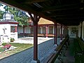
graveyard
The listed cemetery was laid out in 1584 and was given a free-standing pulpit in 1603. There are numerous well-preserved tombstones from past centuries under the arcades. Especially the trading and shipping families of the 18th century were immortalized in the epitaphs .
St. Michael
The Protestant parish church of St. Michael is located in the Michelfeld district .
Main ferry
Until 1955 there was a ferry connection across the Main in Marktsteft. Already in the early Middle Ages there was a crossing possibility near the place, which was leased to different owners by the village lords. The Main ferry had a large catchment area and competed with the nearby ferry in Sulzfeld am Main. After the ferry had increasingly become a subsidy operation in the 20th century, the ferry rights were sold to Sulzfeld am Main in 1955 .
music
Marktsteft has an evangelical trombone choir and a men's choir. The director is Walter Dienesch. The Kesselring musicians have existed since 2003 under the direction of Jochen Münz.
Regular events
Every year the harbor festival, the church fair, the solstice fire and the citizens' ball take place in Marktsteft.
Public facilities
Marktsteft has a library and a museum.
Economy and Infrastructure
Viticulture
Marktsteft is known in the Kitzingen district for its hedge taverns with regional specialties (e.g. Blaue Zipfel ).
economy
In the south there is an industrial park on the bypass in the direction of Marktbreit.
traffic
Marktsteft is close to the A 7 motorway (junction 104, Marktbreit). The place has a bypass through State Road 2271 .
education
Marktsteft has a primary school and a Protestant kindergarten.
societies
Personalities
- Balthasar Böhm († 1530), canon, theologian, writer
- Johann Georg Ulmer († around 1670), historian, writer
- Samuel Ernst Manger (1757–1822), Hofschiffmann
- Johann Ernst Günther (1787–1852), mayor of Marktsteft and member of the state parliament
- Friedrich Wilhelm von Rücker (1803–1870), professor in Erlangen, historian
- Ludwig von Reizenstein (1826–1885), architect and writer
- Theodor Schöntag (1840–1908), historian
- Jörg Geuder (1861–1935), garden writer, poet and language educator, attended the Marktsteft preparatory school for training as a teacher from 1874 onwards
- Albert Kesselring (1885–1960), German field marshal and air force officer
literature
- Johann Kaspar Bundschuh : Steft . In: Geographical Statistical-Topographical Lexicon of Franconia . tape 5 : S-U . Verlag der Stettinische Buchhandlung, Ulm 1802, DNB 790364328 , OCLC 833753112 , Sp. 415-417 ( digitized version ).
- District of Kitzingen (ed.): Art and culture guide through the district of Kitzingen . 2nd Edition. Color printing Brühl, Marktbreit 1993.
- Georg Lill, Friedrich Karl Weysser: The art monuments of Lower Franconia & Aschaffenburg . II City and District Office Kitzingen. Ed .: Bavarian State Office for Monument Preservation (= The Art Monuments of the Kingdom of Bavaria . Volume 3 ). R. Oldenbourg Verlag, Munich 1983.
- Wolf – Armin Frhr. v. Reitzenstein: Lexicon of Franconian place names . CH Beck, Munich 2009, ISBN 978-3-406-59131-0 .
- Gottfried Stieber: Stefft . In: Historical and topographical news from the Principality of Brandenburg-Onolzbach . Johann Jacob Enderes, Schwabach 1761, p. 777-783 ( digitized version ).
- Hans Bauer: Old and new coats of arms in the Kitzingen district . In: Yearbook of the district of Kitzingen 1980. In the spell of the Schwanberg . Kitzingen 1980. pp. 53-70
- Johann Ludwig Klarmann: The Steigerwald in the past. A contribution to Franconian cultural studies . Gerolzhofen 2 1909
Web links
- Official website of the city of Marktsteft
- Entry on the coat of arms of Marktsteft in the database of the House of Bavarian History
- Marktsteft: Official statistics of the LfStat
- Marktsteft: View of the fortified church and gate tower - interactive panorama
Individual evidence
- ↑ "Data 2" sheet, Statistical Report A1200C 202041 Population of the municipalities, districts and administrative districts 1st quarter 2020 (population based on the 2011 census) ( help ).
- ^ Search result for the municipality of Marktsteft. Bayerische Landesbibliothek Online, accessed on September 29, 2014 .
- ^ Wolf-Armin von Reitzenstein : Lexicon of Franconian place names. Origin and meaning . Upper Franconia, Middle Franconia, Lower Franconia. CH Beck, Munich 2009, ISBN 978-3-406-59131-0 , p. 143 ( limited preview in Google Book search).
- ↑ a b c Rudolf Etzelmüller: Marktsteft . In: Jesko Graf zu Dohna (Ed.): In the footsteps of the Counts of Castell . Vier Türme GmbH, Benedict Press, Münsterschwarzach 2004.
- ↑ Obernbreit market. Local history. Retrieved April 3, 2013 .
- ↑ a b c d Fritz Mägerlein: Marktsteft and the six Ansbach "Maindörfer" . Siegfried Greß, Marktbreit 1983, ISBN 3-920094-38-7 .
- ↑ a b Walk 3. The harbor district. Retrieved May 23, 2013 .
- ^ Federal Statistical Office (ed.): Historical municipality directory for the Federal Republic of Germany. Name, border and key number changes in municipalities, counties and administrative districts from May 27, 1970 to December 31, 1982 . W. Kohlhammer GmbH, Stuttgart and Mainz 1983, ISBN 3-17-003263-1 , p. 748 .
- ↑ W. Haberstumpf: The new church administrations according to the law of July 1, 1834 or instructions for the election, property briefing, the sphere of activity and course of business of the church administrations on the basis of the existing laws, ordinances and instructions: according to official Edit sources Ed .: W. Haberstumpf. Pössenbacher, Munich 1834, p. 24 ( mdz-nbn-resolving.de [accessed on July 28, 2013]).
- ↑ Valentin Grübel: Official and address manual for the k. bayer. Administrative district of Lower Franconia and Aschaffenburg: edited from official sources . Ed .: Valentin Grübel. Self-published, Würzburg 1865, p. 36 ( mdz-nbn-resolving.de [accessed October 9, 2013]).
- ↑ Joseph Heyberger, Arthur von Ramberg, Michael Friedrich Heil (eds.): Topographical-statistical manual of the Kingdom of Bavaria . Cotta, Munich 1868, p. 1175–1176 ( mdz-nbn-resolving.de [accessed October 8, 2013]).
- ↑ Bavarian State Office for Statistics and Data Processing (ed.): Statistics communal 2012 . A selection of important statistical data for the city of Marktsteft. Bavarian State Office for Statistics and Data Processing, Munich 2013 ( bayern.de [PDF; accessed on October 15, 2013]). Municipal statistics 2012 ( Memento of the original dated November 30, 2015 in the Internet Archive ) Info: The archive link was inserted automatically and has not yet been checked. Please check the original and archive link according to the instructions and then remove this notice.
- ↑ City Council election 2020 , accessed on June 27, 2020
- ^ Bauer, Hans: Old and new coats of arms in the district of Kitzingen . P. 62.
- ↑ a b c d e f g h i Fritz Mägerlein: St. Stephan Marktsteft . Ed .: Evang. Luth. Marktsteft rectory. Vier – Türme – Verlag, Münsterschwarzach 1973.
- ^ Susanna Berger: City of Marktsteft . In: District Kitzingen (ed.): Art and culture guide through the district Kitzingen . 2nd Edition. Color printing Brühl, Marktbreit 1993.
- ^ German biography: Ludwig von Reizenstein , accessed on June 13, 2019.
- ↑ Klarmann, Johann Ludwig: The Steigerwald in the past . P. 203.

Cities: Dettelbach | Iphofen | Kitzingen | Mainbernheim | Market wide | Marktsteft | Prichsenstadt | Volkach
Markets: Abtswind | Hostage wind | Großlangheim | Kleinlangheim | Einersheim Market | Obernbreit | Rüdenhausen | Schwarzach am Main | Home of being | Wiesentheid | Willanzheim
Municipalities: Albertshofen | Biebelried | Buchbrunn | Castell | Mainstockheim | Martinsheim | Nordheim am Main | Rödelsee | Segnitz | Sommerach | Sulzfeld am Main | Wiesenbronn