
Einersheim market
| coat of arms | Germany map | |
|---|---|---|

|
Coordinates: 49 ° 41 ′ N , 10 ° 18 ′ E |
|
| Basic data | ||
| State : | Bavaria | |
| Administrative region : | Lower Franconia | |
| County : | Kitzingen | |
| Management Community : | Iphofen | |
| Height : | 290 m above sea level NHN | |
| Area : | 7.77 km 2 | |
| Residents: | 1195 (Dec. 31, 2019) | |
| Population density : | 154 inhabitants per km 2 | |
| Postal code : | 97348 | |
| Area code : | 09326 | |
| License plate : | KT | |
| Community key : | 09 6 75 148 | |
| LOCODE : | DE ME2 | |
| Market structure: | 8 districts | |
Market administration address : |
Marktplatz 28 97348 Markt Einersheim |
|
| Website : | ||
| Mayor : | Herbert Volkamer (Free Voters) | |
| Location of the Markt Einersheim market in the Kitzingen district | ||
  |
||

Markt Einersheim , also known as Einersheim , was first mentioned in the 9th century as "Einheresheim" and is a market in the Kitzingen district in Lower Franconia . He belongs to the administrative community Iphofen . It is located on the old army and trade connection from Nuremberg to Frankfurt am Main on the edge of the Steigerwald .
The municipality of Markt Einersheim has an area of about 7.74 square kilometers. It is a market with visible remains of the former fortified church and the fortifications. Some old half-timbered buildings , the castle and the modern fountain make up the market square . Vineyards, forest areas, meadows and arable land still shape the rural character of the village despite the large factories outside the town center.
In earlier times Markt Einersheim was connected to two large cities, Würzburg and Nuremberg , by road and rail . The residents earned their living on the Alte Reichsstraße with agriculture and trade. In addition, the place suffered over the centuries in numerous armed conflicts between the sovereigns from soldiers passing through and taking quarters. This was true of both friends and foes.
The 20th century brought economic change in Markt Einersheim. With the settlement of three large farms, agriculture faded into the background. The Fritsch company expanded in the middle of the last century and the Fuchs bakery came to town. The factory of the Knauf Group was born. Numerous other companies have since settled in the market.
geography
location
Markt Einersheim is located in the Würzburg region (Bavarian planning region 2) and belongs to the Hellmitzheim Bay . This pushes itself deep into the Steigerwald and opens westward to the Main valley. The village of Kirchheim lies on the boundary of the Iphöfer district of Possenheim . The village was abandoned in the 13th century. A similar situation is assumed for the Eckelsheim desert . In contrast, the Sackshof is suspected to be near the new building yard .

geology
In terms of nature, Einersheim lies on the border of two main unit groups. The south of the municipality with the main town of Einersheim is part of the Schwanbergvorland , which is characterized by rolling hills. The Northern Steigerwald begins in the north with much higher elevations.
The Steigerwald belongs to the Keuper level of the south-west German layer level country . Hellmitzheim Bay is located in the Gipskeuper zone. The boundary of the sandstone keuper is identical to the tree boundary.
To the south of the village, the Moorseebach runs through the Mühlengrund with old polluted willows and wet meadows. The four mills were previously used to grind the farmers' grain. A section of the Mühlengrund is part of the Natura 2000 network and designated as a protected area DE6327302, tufa springs between Willanzheim and Markt Einersheim .
Community structure
Markt Einersheim is an independent municipality. From 1862 to 1972 it belonged to the Scheinfeld district in the Middle Franconia administrative region. On July 1, 1982, the move to the Kitzingen district took place. The market town merged on May 1, 1978 with Rödelsee, Markt Willanzheim and the city of Iphofen to form an administrative community.
Eight districts belong to Markt Einersheim:
|
There is only the district of Markt Einersheim.
Neighboring communities
Markt Einersheim is almost completely enclosed by the neighboring town of Iphofen ( Kitzingen district , Lower Franconia ). In the east the place borders for a short distance on Markt Bibart ( district Neustadt an der Aisch-Bad Windsheim , Middle Franconia ).
climate
The climate here is mild and dry.
history
Place name
The place was called EinJirihesheim or Einheresheim in the 9th century . The basic word is home in Old High German , which means apartment, dwelling, home or place of residence. The personal name EiniJirih is added as a defining word . Later forms of the name were:
|
|
|
|
From 1530 the supplement market denotes the legal status of being able to hold markets.
Local history
Row grave finds near the market point to the first settlement around 600. The place was probably founded at the time of the Frankish conquest .
In 837 an Arnhelm donated a property in Wingartesheim to the Fulda monastery . According to the location description, it is a place near Markt Einersheim. In the Wildbann - deed of gift from Emperor Heinrich II . to the Hochstift Würzburg from the year 1023 the place is then given as Aingerichesheim .

"Einresheim" appeared for the first time in 1144 in a document from Haug Abbey in Würzburg. In 1148 a "Helwic de Enrsheim" appeared as a nobleman in the documents. He could already have been the builder of Speckfeld Castle . "Villa Einrisheim" belonged in the Castell's deed of division from 1266 to the possession of the Counts of Castell . Ludwig von Hohenlohe received in 1349 for his services from Emperor Karl IV . Customs and escort "to Enersheim under Speckfeld" as a fief. Since he died without a male heir, this share of the property passed to his brothers-in-law. Count Leonhard zu Castell received Speckfeld Castle with a tower and the lower part of the village with the village mill. Schenk Friedrich von Limpurg owned a stone bower and the upper part of Markt Einersheim with the Eckelheimer mill.
In 1435 and 1445 the Limpurg taverns also acquired the property of Count Wilhelm II zu Castell , but without the Speckfelder Wildbann. In the following 300 years, the people of Limpur chose the Speckfeld Castle as their residence. This was destroyed in the Peasants' War, but was later rebuilt. Reichserbschenk Carol von Limpurg raised the place to a market town in 1542 . During the Thirty Years' War, Speckfeld Castle suffered from several looting by Swedish and imperial troops. Because of its ailing condition, Vollrath von Limburg gave up Speckfeld Castle. In 1685 he built a new half-timbered castle in Markt Einersheim. With the death of the last taverns in 1705 and 1713, the imperial fiefs went to Brandenburg. Ownership of the Speckfeld lordship with the castles Markt Einersheim and Sommerhausen passed to the Counts von Rechteren through the daughter of Amalie, the Schenken Eberhard . Until the middle of the 20th century they had a residence in the named places.
Since the Rhine Confederation Act of 1806, the place, like large parts of Franconia, has belonged to the Kingdom of Bavaria . Since 1972 the village has belonged to the district of Lower Franconia and since 1978 to the administrative community of Iphofen.
On March 23, 1972, the community name Einersheim was officially changed to Markt Einersheim.
Population development

| year | 1840 | 1846 | 1861 | 1867 | 1871 | 1900 | 1925 | 1939 | 1950 | 1961 | 1970 | 1987 | 1991 | 1995 | 2000 |
|---|---|---|---|---|---|---|---|---|---|---|---|---|---|---|---|
| Residents | 798 | 770 | 729 | 774 | 774 | 739 | 692 | 700 | 1081 | 1019 | 1033 | 1114 | 1234 | 1281 | 1247 |
| year | 2002 | 2003 | 2004 | 2005 | 2006 | 2007 | 2008 | 2009 | 2010 | 2011 | 2012 | 2013 | 2014 | 2015 | 2016 |
|---|---|---|---|---|---|---|---|---|---|---|---|---|---|---|---|
| Residents | 1210 | 1200 | 1211 | 1181 | 1171 | 1146 | 1175 | 1151 | 1165 | 1202 | 1201 | 1203 | 1194 | 1187 | 1202 |
Source of the information without individual reference: Bavarian State Office for Statistics and Data Processing
politics
mayor
Herbert Volkamer (Free Voters) has been mayor since May 1, 2014; he was elected for a further six years on March 15, 2020 with 98.9% of the valid votes. His predecessor was Bruno Gamm (independent electorate).
coat of arms
|
|
Blazon : "In silver, a bunch of six berry-shaped red fruits with long green stems, which are held together by a gold ring at the bottom." |
| Founding of the coat of arms: Einersheim probably got the market rights in 1542. In the oldest known court seal, the legend also says the year 1542. The place name Markt Einersheim appeared for the first time in 1801. The meaning of the six fruits depicted in the coat of arms, the stems of which are held together by a ring, is unclear. They are thought of as either rose hips or poppy seed capsules. King Ludwig approved the continuation of the old coat of arms on July 6, 1847. In the writing the fruits are referred to as hifts (rose hips) or as wooden pears. Colors were not mentioned in this approval. They come from Otto Hupp's coat of arms collection. |
Culture and sights

Ruins of the mountain castle Speckfeld
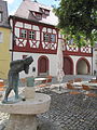
Richard Rother's fountain on the market square

Town hall with access to the former fortified church

St. Matthew

Wurzburg Gate
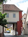
Nuremberg Gate


Architectural monuments
Gatehouses
In the 14th century the gatehouses were built at the street entrances to the village.
The shepherd's gate is no longer there. It was demolished in 1867.
One floor of the Würzburger Tor with the apartment for the hallway and night watchman was demolished in 1680. It has housed a local history museum since 1980. After its major renovation in 1999, it is an appealing testimony to the past.
The Nuremberg Gate was also reduced by one floor in 1728. The community archive has been housed there since 1983.
Fortified church
investment


The location of the Evangelical Lutheran parish church of St. Matthew on a hill indicates its original protective function for the population. The ridge falls on three sides. When it was expanded into a fortified church , only the north side had to be reinforced for defense purposes. The choir tower is in the middle of the complex and opposite the entrance. It has a wall thickness of 1.15 m and there was no access to the top from the ground floor. The entrance to this last refuge was only accessible via ladders. Its narrow windows on the second floor are evidence of former loopholes . At the top this fortified tower had a battlement . From there, guards could observe the area from afar.
Until 1599 there was a churchyard around the church, which was surrounded by a defensive wall with corner towers. The Castell – Limpurgian deed of partition of September 23, 1414 reports of two opposite entrances to the churchyard. The church gate was on the north side at the point of the passage under the town hall. On an almost straight line past the defense tower was the little church on the south side. Approx. The soul measuring chapel was attached to the defensive wall 5 meters to the east. Only two Gothic entrances still remember her. In 1682 it was used as the "Beinhauß im Kirchhoff".
Church building
Presumably, a previous wooden building had existed since the time of the Franconian Apostle Kilian . This assumption is confirmed by the fact that in 742 the church of Dornheim was mentioned as a daughter church of Markt Einersheim.
The current church with a choir tower is dedicated to St. Matthew . It was given its current appearance in 1626 when the nave was extended to the north. The tower and the south wall remained. The old mess church was transformed into a Protestant preaching church and three altars were "removed as the last remnants of the papacy".
The choir has a Gothic ribbed vault . It sits on capitals, a girl's head with leaf buds. The nave has a wooden coffered ceiling. In the middle is the coat of arms of the bar with the year 1626. Several epitaphs for deceased members of the bar in Limpurg-Speckfeld were hung around the choir arch.
town hall
The town hall was built in 1567/68. It is a two-story building with a hipped roof and half-timbering on the upper floor.
Bacon Field
The tower ruins of the mountain castle Speckfeld are visible from afar on a mountain cone north of Markt Einersheim . The Knights of Speckfeld probably chose the hill to build their castle around 1200. From here they were able to guard and protect the old elevated road that led through the damp meadow. Today not much of the mountain castle has survived, because from 1700 the dilapidated building was used as a quarry. In 1716 the gable of the parish church St. Matthäi as well as the wall of the western churchyard are repaired with these stones.
lock

After Schenk Vollrath von Limpurg had given up Speckfeld Castle, he built a new residence in the village in 1685 in half-timbered construction on the market square.
The castle was passed on to the Counts of Rechteren-Limpurg through the daughter of Amalie, the last gift from Georg Eberhard . In 1859, under Count Friedrich Ludwig von Rechteren-Limpurg-Speckfeld, the two-story extension was built in the neo-Gothic style with a broad front facing the street. The coats of arms of the builder and his wife Luitgard Countess von Erbach-Fürstenau are recorded above the entrance portal.
In 1969 Nikolaus Knauf acquired it from the heirs of Countess Adolphine von Rechteren – Limpurg – Speckfeld.
Nature reserves

Schlossberg
The information board at the Schlossbergsattel nature reserve near Markt Einersheim shows that the Schlossberg is 410 m high and lies on the southern edge of the southern tip of the Steigerwald. The reason for the formation of the slopes and the plateau are the layers of different hardness of the middle Keuper. Reed sandstone is stored on the Schlossbergsattel.
The protected area has a size of approx. 78 ha. The area belongs to the European network of protected areas Natura 2000 and consists of small plots of arable land with different uses. Numerous endangered plants and animals have been preserved there. For example, the remains of the Speckfeld castle ruins offer refuge for various bat species.
societies
- Historical fraternity market Einersheim
- Voluntary fire brigade Markt Einersheim eV
- Choral Society 1864 Markt Einersheim
- Kindergarten Friends' Association
- Small animal breeding association Markt Einersheim u. Surroundings from 1988 eV
- Warrior and military fellowship 1872.
- Count's rifle club from 1603 e. V. Market Einersheim
- Folk costume association Markt Einersheim e. V.
- Project orphanage Sri Lanka e. V.
- Sports club Markt Einersheim e. V
These ten associations shape the community life in the village.
Economy and Infrastructure
traffic
The B 8 running through Markt Einersheim no longer crosses the town center after the construction of the bypass road, but has been laid to the north of its original location. It separates the industrial area of the Knauf company and the town.
In 1865 Markt Einersheim was given a train station on the Nuremberg – Würzburg railway line . It runs southwest of Markt Einersheim. Until 1982 there was a stop for passenger traffic here. After the expansion of this main line from Nuremberg to Würzburg in Franconia , the frequency of ICE, freight and regional trains is steadily increasing today.
The Franconian Marienweg runs through Markt Einersheim .
Industry and economy
The place was on an important east-west connection, the Alte Reichsstraße . It was a long-distance trade and military route from Nuremberg to Frankfurt and the continuation of the Golden Road from Prague to Nuremberg. On the busy road through armies, merchants and traders, inns and craftsmen such as blacksmiths, wagons and saddlers played an important role in earlier times. In addition, Markt Einersheim was characterized by agriculture until the 20th century. Viticulture in particular still bears witness to the former rural structure of the market town. The previously numerous small vineyards of Markt Einersheim have been combined to form the Einersheimer Vogelsang . This Franconian wine grows on the southern slopes around the Wengertshäusla and on the Sonnberg and Schlossberg. At 50 hectares north of the main road, the area is quite considerable.
In 1998, according to official statistics, there were 413 employees at the place of work in the manufacturing sector and 73 in the trade and transport sector. In other economic sectors, 72 people were employed at the place of work subject to social security contributions. There were a total of 746 employees at the place of residence subject to social security contributions. There were none in manufacturing and 1 in construction. In addition, in 1999 there were 41 farms with an agricultural area of 1,202 ha, of which 875 ha were arable land and some ha were permanent green space.
Today there are around 600 jobs available in the market town with a population of 1250 people. There are businesses, craftsmen, service providers and small companies. The following larger companies are based in the area:
"Fritsch Bakery Equipment and Technology" was founded in 1926. The company expanded in the middle of this century with the creation of tools that helped streamline the bakery.
The Knauf Gips factory was created in 1943 as a result of the massive gypsum deposits at the gates of Markt Einersheim.
The "Marktbäckerei Fuchs" started in 1900 in the Sudetenland and came to the place with the resettlement in 1953.
The "Meidel Group" is a forwarding and logistics company. It was founded in Wroclaw in 1906. Reconstruction began in 1948 after the eviction, first in Markt Bibart and then at today's headquarters in Markt Einersheim in Lower Franconia.
The company "Böhm-Bau" GmbH from Markt Einersheim has been known for its timber construction since 1696. Due to the need to save energy, timber house construction in particular boomed in the plant.
“SG Stahl Großküche” GmbH, a company of the Blanco Professional Group, is also based in Markt Einersheim.
Viticulture

Markt Einersheim is today a wine-growing area in the Franconian wine-growing region . A total of two vineyards exist around the village, the wine has been marketed under the names Markt Einersheimer Vogelsang and Markt Einersheimer Mönchshütte (formerly Stüblein) since the 1970s. Einersheim is part of the Schwanberger Land area, until 2017 the winemakers were grouped together in the Steigerwald area. The Keuperböden with a high proportion of gypsum around Markt Einersheim are also suitable for growing wine, as is the location in the Maingau climate zone, which is one of the warmest in Germany.
The people around Einersheim have been growing wine since the early Middle Ages . The Franconian settlers probably brought the vine to the Main in the 7th century. In the Middle Ages, the region was part of the largest contiguous wine-growing region in the Holy Roman Empire. The vine was first mentioned in the village in a deed of ownership from the Bamberg Monastery near Speckfeld Castle. The people mostly operated part-time viticulture for self-sufficiency , at the same time export centers were already emerging, especially along the Main. The people of Einersheim sold their wine in nearby Iphofen.
Viticulture experienced a major decline after secularization at the beginning of the 19th century. Above all, locations with less favorable climatic conditions were completely abandoned. In addition, the emergence of pests such as phylloxera made cultivation difficult . Soon there were no more vineyards in Einersheim. The Franconian wine-growing region was not able to consolidate again until the second half of the 20th century. The use of fertilizers and improved cultivation methods had contributed to this, as had the organization in cooperatives and the land consolidation of the 1970s. Today, wine is grown in the village again to a limited extent.
| Vineyard | Size 1993 | Size 2019 | Compass direction | Slope | Main grape varieties | Great location |
|---|---|---|---|---|---|---|
| Monk's hut | 6.5 ha | 12 ha | south | 20-40% | Müller-Thurgau , Kerner , Faber | Iphöfer Burgweg |
| Vogelsang | 28 ha | 76 ha | South, west | 20-50% | Silvaner , Müller-Thurgau | Iphöfer Burgweg |
Public facilities
The market town has all the facilities necessary for life: kindergarten, elementary school, dentist, pharmacy, baker, butcher, grocery store, banks and hairdresser.
education

There is a kindergarten and a crèche in the market town.
School instruction was in the hands of the church until the state took over in 1919. For this reason, the school building was located in the immediate vicinity of the church. As early as 1558, the current house on Marktplatz 4 was built as the first schoolhouse in Markt Einersheim. The classroom for all school-age children was located above the teacher's apartment on the ground floor.
In 1881 the market decided to build a new school building on the south side of the church. This contained two classrooms. When the building became too small again, the market built the four-class schoolhouse in 1963 with a school kitchen, work room and gymnastics hall. At the beginning of the 1972/73 school year, grades 7 - 9 attended the Iphofen Association School. Since 1981 only the children of the Hellmitzheimer Bucht elementary school have been taught in the building. They come from Possenheim, Hellmitzheim, Dornheim, Nenzenheim, Mönchsondheim and Markt Einersheim. Another extension was added in 1993. From the year 2000 the elementary school children of the association school had the possibility of lunchtime care. The next high schools are Kitzingen and Scheinfeld.
The community library is located in the building of the Hellmitzheimer Bucht primary school. It is well equipped and offers reading material for every taste.
Sports
The market town has a sports center with a multi-purpose hall, a sports field, football field and children's playground.
The outdoor terrace swimming pool in Mühlengrund is an attraction for the citizens of Markt Einersheim and numerous visitors from the surrounding towns in summer.
For hikers, the Speckfelder Runde nature adventure trail opens up the vicinity of Markt Einersheim.
Due to its location on the Steigerwald Panoramaweg from Bamberg to Bad Windsheim, the village is embedded in the Franconian diversity.
With two routes of 25 km (cycle path no. 9) and 33 km (cycle path no. 7), the long-distance cycle path from Main to Aisch touches the town. It is described on the Kitzingen district cycling map.
Personalities
- Carolus Schenk zu Limpurg – Speckfeld (1498–1558) raised Markt Einersheim to market in 1542. He also introduced the Reformation in 1550.
- Joseph Winzheimer (1807–1897), member of the state parliament, Winzheimer also worked as a regional court doctor in Markt Einersheim.
- Friedrich Ludwig von Rechteren-Limpurg-Speckfeld (1811–1909), Bavarian Imperial Councilor, was born in Markt Einersheim.
- Wilhelm Sebastian Schmerl (born February 18, 1879 in Markt Einersheim; † May 8, 1963 in Würzburg ), local writer and church councilor, author of the works “The Pastor of Gollhofen”, “Kaspar Lederer, the Schulz” and others. a.
- The dentist Otto Hellmuth (1896–1968), Gauleiter of the NSDAP and district president of Mainfranken in the National Socialist German Reich , was born in Markt Einersheim.
- Fritz Ortner (born September 23, 1913; † 2005), former mayor and local chronicle, received the Federal Cross of Merit for his services to Markt Einersheim. A street was also named after him.
- Nikolaus Knauf (* 1936), who has received numerous international honors, is an honorary citizen of Markt Einersheim. In 1969 Nikolaus Knauf acquired the castle from the heirs of the von Rechteren –Limpurg – Speckfeld family . He renovated it and made the market town his home. The new citizen took part in the political events in the town and district. Nikolaus-Knauf-Strasse was named in his honor.
literature
- Hans Ambrosi , Bernhard Breuer: German Vinothek: Franconia. Guide to the vineyards, winegrowers and their kitchens . Herford 2 1993.
- Hans Bauer: Old and new coats of arms in the Kitzingen district . In: Yearbook of the district of Kitzingen 1980. In the spell of the Schwanberg . Kitzingen 1980. pp. 53-70.
- Johann Kaspar Bundschuh : Markteinersheim . In: Geographical Statistical-Topographical Lexicon of Franconia . tape 3 : I-Ne . Verlag der Stettinische Buchhandlung, Ulm 1801, DNB 790364301 , OCLC 833753092 , Sp. 445 ( digitized version ).
- Wolf – Armin Frhr. v. Reitzenstein : Lexicon of Franconian place names . CH Beck, Munich 2009, ISBN 978-3-406-59131-0 .
- District of Kitzingen (ed.): Art and culture guide through the district of Kitzingen . 2nd Edition. Kitzingen 1993, DNB 871400847 .
- Deanery Markt Einersheim (Ed.): Deanery Markt Einersheim . Evangelical parishes in the Steigerwald. Verl. D. Evangelical Luth. Mission, Erlangen 1978, ISBN 3-87214-092-2 .
- Peter Schneider: Between the Main and Steigerwald (= Mainfränkische Heimatkunde 1) . Würzburg 1955.
- Pleikard Joseph Stumpf : Market Einersheim . In: Bavaria: a geographical-statistical-historical handbook of the kingdom; for the Bavarian people . Second part. Munich 1853, p. 695-696 ( digitized version ).
Web links
- Entry on the coat of arms of Markt Einersheim in the database of the House of Bavarian History
Individual evidence
- ↑ "Data 2" sheet, Statistical Report A1200C 202041 Population of the municipalities, districts and administrative districts 1st quarter 2020 (population based on the 2011 census) ( help ).
- ↑ a b c d e f Fritz Ortner: Illustrated guide through market Einersheim and its history . Ed .: Markt Markt Einersheim. Hügelschäffer printing works, Mainbernheim 1986.
- ↑ Markt Einersheim: Sights , accessed on June 12, 2015
- ↑ Natura 2000: DE6327302, Kalktuffquellen between Willanzheim and Markt Einersheimd (accessed on June 12, 2015)
- ↑ bayerische-landesbibliothek-online.de
- ↑ Wolf – Armin Frhr. v. Reitzenstein: Lexicon of Franconian place names . CH Beck, Munich 2009, ISBN 978-3-406-59131-0 , p. 140 .
- ↑ a b c d August Bomhard, Fritz Ortner: 700 years of the parish of Markt Einersheim . Local and parish chronicle. Ed .: Marktgemeinde Markt Einersheim. Druck + Papier Meyer GmbH, Scheinfeld 1997, ISBN 3-89014-117-X .
- ↑ Jesko Graf zu Dohna: Market Einersheim . In: Jesko Graf zu Dohna (Ed.): In the footsteps of the Counts of Castell . Princely Castell'sches Archiv, Castell 2004, OCLC 163177794 , p. 41-45 .
- ^ Wilhelm Volkert (ed.): Handbook of Bavarian offices, communities and courts 1799–1980 . CH Beck, Munich 1983, ISBN 3-406-09669-7 , p. 565 .
- ^ Eduard Vetter: Statistical handbook and address book of Middle Franconia in the Kingdom of Bavaria . Eduard Vetter. Self-published, Ansbach 1846, p. 269 ( Digitale-sammlungen.de [accessed June 17, 2013]).
- ↑ Speckner Josef: Directory of the communities of the Kingdom of Bavaria with their population in December 1861 . Ed .: Speckner Josef. Zängl, Munich 1863, p. 147 ( mdz-nbn-resolving.de [accessed September 25, 2013]).
- ↑ k. statistical bureau (ed.): Directory of the municipalities of the Kingdom of Bavaria . according to the status of the population in December 1867, with classification according to family, gender and religious background. Ackermann, Munich 1869, p. 173 ( [1] [accessed September 25, 2013]).
- ↑ Bavarian State Office for Statistics and Data Processing (ed.): Statistics communal 2012 . A selection of important statistical data for the market Einersheim market. Bavarian State Office for Statistics and Data Processing, Munich 2012 ( bayern.de [PDF; accessed on September 25, 2013]).
- ^ Bauer, Hans: Old and new coats of arms in the district of Kitzingen . P. 62.
- ↑ a b c d e f Welcome to Markt Einersheim. Retrieved June 5, 2013 .
- ^ Hans Sommer: Einersheim market . In: Deanery Markt Einersheim . Evangelical parishes in the Steigerwald. Verlag der Ev. – Luth.Mission, Erlangen 1978, ISBN 3-87214-092-2 , p. 58 .
- ^ Fritsch website
- ↑ website of market Bakery Fuchs
- ↑ Website of Meidel Group
- ^ Website of Böhm Bau
- ↑ Website ( Memento of the original from October 5, 2013 in the Internet Archive ) Info: The archive link was inserted automatically and has not yet been checked. Please check the original and archive link according to the instructions and then remove this notice. of SG Stahl Großküche GmbH
- ^ Ambrosi, Hans (among others): German Vinothek: Franconia . Pp. 50-52.
- ↑ Government of Lower Franconia: Vineyards in Bavaria broken down by area ( Memento of the original from July 28, 2018 in the Internet Archive ) Info: The archive link was automatically inserted and not yet checked. Please check the original and archive link according to the instructions and then remove this notice. , PDF file, accessed May 16, 2019.
- ^ Ambrosi, Hans (among others): German Vinothek: Franconia . P. 237.
- ↑ Steigerwald Nature Park. Retrieved September 10, 2013 .
- ^ Schneider, Peter: Between Main and Steigerwald . P. 189.

Cities: Dettelbach | Iphofen | Kitzingen | Mainbernheim | Market wide | Marktsteft | Prichsenstadt | Volkach
Markets: Abtswind | Hostage wind | Großlangheim | Kleinlangheim | Einersheim Market | Obernbreit | Rüdenhausen | Schwarzach am Main | Home of being | Wiesentheid | Willanzheim
Municipalities: Albertshofen | Biebelried | Buchbrunn | Castell | Mainstockheim | Martinsheim | Nordheim am Main | Rödelsee | Segnitz | Sommerach | Sulzfeld am Main | Wiesenbronn
At the Kühbuck | At the water house | Donkey mill | Einersheim Market | New courtyard | Schwarzmühle | Secretary Mill | Stone mill