
Administrative community Iphofen
| coat of arms | Germany map | |
|---|---|---|
 Help on coat of arms |
Coordinates: 49 ° 42 ' N , 10 ° 16' E |
|
| Basic data | ||
| Existing period: | 1978– | |
| State : | Bavaria | |
| Administrative region : | Lower Franconia | |
| County : | Kitzingen | |
| Area : | 122.46 km 2 | |
| Residents: | 9281 (Dec. 31, 2019) | |
| Population density : | 76 inhabitants per km 2 | |
| License plate : | KT | |
| Association key : | 09 6 75 5616 | |
| Association structure: | 4 municipalities | |
| Association administration address : |
Marktplatz 28 97346 Iphofen |
|
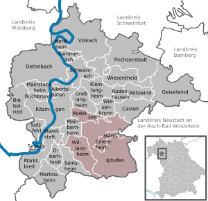
| Location of the Iphofen administrative community in the Kitzingen district | ||
  |
||

In the administrative community of Iphofen in the Lower Franconian district of Kitzingen , the following communities have come together to handle their administrative business:
- Iphofen , town with 4667 inhabitants, 78.06 km²
- Markt Einersheim , market , 1195 inhabitants, 7.77 km²
- Rödelsee , population 1822, 11.5 km²
- Willanzheim , market , population 1597, 25.13 km²
The administrative association founded in 1978 is based in Iphofen.
The town of Mainbernheim also belonged to the administrative community until December 31, 1979 .
Individual evidence
- ↑ "Data 2" sheet, Statistical Report A1200C 202041 Population of the municipalities, districts and administrative districts 1st quarter 2020 (population based on the 2011 census) ( help ).
- ↑ Dismissal by law on changing the membership of municipalities in administrative communities of 10 August 1979 ( GVBl p. 223)
Administrative communities in the Kitzingen district
Großlangheim | Iphofen | Kitzingen | Market wide | Volkach | Wiesentheid