Home of being
| coat of arms | Germany map | |
|---|---|---|

|
Coordinates: 49 ° 38 ' N , 10 ° 13' E |
|
| Basic data | ||
| State : | Bavaria | |
| Administrative region : | Lower Franconia | |
| County : | Kitzingen | |
| Management Community : | Market wide | |
| Height : | 252 m above sea level NHN | |
| Area : | 17.51 km 2 | |
| Residents: | 1071 (Dec. 31, 2019) | |
| Population density : | 61 inhabitants per km 2 | |
| Postal code : | 97342 | |
| Area code : | 09332 | |
| License plate : | KT | |
| Community key : | 09 6 75 167 | |
| Market structure: | 15 districts | |
Market administration address : |
Rathausplatz 1 97342 Seinsheim |
|
| Website : | ||
| Mayoress : | Ruth Albrecht (independent) | |
| Location of the Seinsheim market in the Kitzingen district | ||
Seinsheim is a market in the Lower Franconian district of Kitzingen and a member of the Marktbreit administrative association .
geography
Geographical location
The Seinsheim market is located on the southern foothills of the Steigerwald . The eponymous village is characterized by viticulture . In the south-east of the municipality is the so-called Kunigunden Forest , which in the Middle Ages was used jointly by a total of eight villages in the area.
Community structure
Seinsheim is divided into 15 districts:
|
Neighboring communities
Neighboring communities are (starting from the north in a clockwise direction): Willanzheim , Ippesheim , Martinsheim , Obernbreit and Marktsteft .
Natural location
In terms of natural space , Seinsheim and its districts have a share in several natural spaces, including the Ifftal area , which is part of the Ochsenfurter and Gollachgau . The villages and mills are located in the valleys of the Breitbach or the Iff and their tributaries, the arable land on the plateau of the fertile Gäuland.
history
The place name with its final syllable -heim refers to the expansion of the place during the Frankish colonization at the end of the 7th century. The place of being home was already in pre- and early historic settled time point after which series grave findings in the 1920s and 1930s.
The place Seinsheim was first mentioned in the first half of the 9th century. He was a central place of the early Iffgau with an original parish (St. Peter). The place was referred to in older literature together with the neighboring villages of Herrnsheim, Iffigheim and Weigenheim as an imperial village that was only subordinate to the emperor. Today it is assumed that the emperor only managed Würzburg goods in part. In 1147 Eispertus de Souvensheim from a local noble family of Würzburg feudal people was first mentioned in the village.
After the decline of the Staufer shortly after 1260, the Hohenlohe took over the "imperial estates under the mountains" ( bona sub montibus ). As of trial of centering Hohenlandenberg came Seinsheim 1415 to Erkinger of being home Stephan Berg . Erkinger soon named himself after the Schwarzenberg Castle near Scheinfeld he had bought and became the progenitor of today's Prince of Schwarzenberg .
In 1434 Seinsheim received market rights from Emperor Sigismund at the request of Erkinger . Until 1806 Seinsheim belonged to the Lords / Counts / Princes of Schwarzenberg, who carried out the Counter Reformation there in 1626/27 and made Seinsheim Catholic again. The town of Seinsheim has nothing to do with the lordship or county of Seinsheim represented at the Franconian district council, whose focal points were Marktbreit and Markt Nordheim / Seehaus.
The place was secured with fence, ditch and two gatehouses, because "Johann von Schwarzenberg issued the market town in 1502 for all time the Umgeld , with the condition so as to obtain gates, ditches and walls." Seinsheim continued to serve as a court of the seat of the centering Hohenlandenberg the Schwarzenberg rule, which from 1500 belonged to the Franconian Empire and in 1806 fell to the Kingdom of Bavaria .
As part of the municipal reform , the previously independent towns of Iffigheim, Wässerndorf and Tiefenstockheim were incorporated on May 1, 1978.
politics
Mayoress
Ruth Albrecht was nominated for the election on March 15, 2020 by four groups of voters and was elected with 93.9% of the valid votes. She took office on May 1, 2020. Your predecessor, Heinz Dorsch, was nominated by several groups of voters for 30 years, from May 1, 1990 to April 30, 2020.
coat of arms
| Blazon : "Three blue poles in silver, covered as a whole with a slanted golden wavy bar." | |
| Justification of the coat of arms: The coat of arms goes back to the noble family of those von Seinsheim , who had their ancestral seat here. The most important representatives were Erkinger , Landkomtur of the Teutonic Order; Johann "the Strong" von Schwarzenberg (around 1500), Adam Friedrich von Seinsheim , Prince-Bishop of Würzburg (1755–1779) and Bamberg (1757–1779), his brother the Bavarian General Minister, builder of Sünching Castle , the Austrian general in the Napoleonic Empire Kriegen Karl Schwarzenberg , the Austrian Prime Minister Felix von Schwarzenberg (around 1850) and other princes up to the former Czech Minister Karel Schwarzenberg .´ |
| Tiefenstockheim coat of arms | |
| Blazon : “St. Kilian in a gold bishop's robe and miter, in his right hand the silver sword, in the left the crook; a tree stump below in silver " | |
| Justification of the coat of arms: The upper part refers to the historical affiliation of Tiefenstockheim to the Hochstift Würzburg, the lower part symbolizes the place name. The tinging in silver and red alludes to the coat of arms of the Würzburg monastery. |
Attractions
Seinsheim has become increasingly touristy. The Weinparadies Franken association , consisting of Lower and Middle Franconian wine-growing communities around Seinsheim, has made a significant contribution to this.
Architectural monuments
- Town hall from the 17th century with pillory
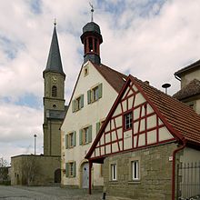
- Catholic Church of St. Peter and Paul : It was rebuilt from 1810 to 1814. The ensemble of Kirchengaden extends around the church. Today it houses the smallest brewery in Lower Franconia, as well as youth and exhibition rooms.
- Kirchgaden
- Statue of Maria Immaculata in Frankenstrasse (Schilling family) and a number of wayside shrines in the hallway
More Attractions
- Tree horoscope trail: The Seinsheim tree horoscope trail leads around the landscape lake and through the village and is a special kind of tree nature trail. Over a length of around 1.8 kilometers, it conveys the mysticism of a horoscope that goes back to Celtic origins with the knowledge of a tree trail. The hiker receives cultic, cultural, historical and medical information about the trees on 21 themed boards.
- Wayside shrine
- Landscape lake
Viticulture
Seinsheim is a Franconian wine-growing town. The vineyards (approx. 40 hectares) are located east of the village on the slope of the Bullenheimer Berg on Keuperböden in west and south locations. The wine has been marketed under the name "Seinsheimer Hohenbühl" since the 1970s. Seinsheim is part of the Weinparadies area, until 2017 the winemakers were grouped together in the Steigerwald area. The gypsum keuper soils around Seinsheim are just as suitable for growing wine as the location in the Maingau climate zone, which is one of the warmest in Germany.
The people around Seinsheim have been viticulture since the early Middle Ages . The Franconian settlers probably brought the vine to the Main in the 7th century. In the Middle Ages, the region was part of the largest contiguous wine-growing region in the Holy Roman Empire. The people mostly operated part-time viticulture for self-sufficiency , at the same time export centers were already emerging, especially along the Main. The people of Seinsheim produced the wine on the one hand for the ecclesiastical and secular feudal lords (tithes, wine gins - a kind of lease), sold it to the wine trade and of course needed it for domestic use.
Viticulture experienced a major decline after secularization at the beginning of the 19th century. Above all, locations with less favorable climatic conditions were completely abandoned. In addition, the emergence of pests such as phylloxera made cultivation difficult . The Franconian wine-growing region was not able to consolidate again until the second half of the 20th century. The use of fertilizers and improved cultivation methods had contributed to this, as had the organization in cooperatives and the land consolidation of the 1970s.
Seinsheim is shaped by this centuries-old wine culture, so the church, which was newly built at the beginning of the 19th century, was completely basement in order to be able to store wine barrels here. The grape varieties Müller-Thurgau, Silvaner, Traminer and Bacchus (as white wine) as well as Dornfelder, Portugieser and Domina (as red wine) are grown on around 40 hectares in Seinsheim . The focus of the festival calendar is the Seinsheim Wine Festival , which is celebrated annually at the beginning of June.
| Vineyard | Size 1993 | Compass direction | Slope | Main grape varieties | Great location |
|---|---|---|---|---|---|
| Hohenbuehl | 40 ha | west | 15-35% | Silvaner , Müller-Thurgau , Traminer | Frankenberg castle piece |
literature
- Hans Ambrosi, Bernhard Breuer: German Vinothek: Franconia. Guide to the vineyards, winegrowers and their kitchens . Herford 2 1993.
- Johann Kaspar Bundschuh : Seinsheim . In: Geographical Statistical-Topographical Lexicon of Franconia . tape 5 : S-U . Verlag der Stettinische Buchhandlung, Ulm 1802, DNB 790364328 , OCLC 833753112 , Sp. 281-282 ( digitized version ).
- Otto Selzer: City and VG Marktbreit . In: District Administrator and District Council of the District of Kitzingen (ed.): District of Kitzingen . Münsterschwarzach 1984. pp. 576-596.
- Pleikard Joseph Stumpf : Market Seinsheim . In: Bavaria: a geographical-statistical-historical handbook of the kingdom; for the Bavarian people . Second part. Munich 1853, p. 698 ( digitized version ).
- Eberhard Graf Fugger, The Seinsheims and their time, Munich 1893
Web links
- Official website
- Historical atlas from Bayern Band Kitzingen, esp.p. 176
- Seinsheim: Official statistics of the LfStat
Individual evidence
- ↑ "Data 2" sheet, Statistical Report A1200C 202041 Population of the municipalities, districts and administrative districts 1st quarter 2020 (population based on the 2011 census) ( help ).
- ↑ http://www.bayerische-landesbibliothek-online.de/orte/ortssuche_action.html ? Anzeige=voll&modus=automat&tempus=+20111114/174524&attr=OBJ&val= 1672
- ↑ Geography Giersbeck: Map 152 Würzburg , PDF file, accessed on January 8, 2019.
- ↑ Selzer, Otto: City and VG Marktbreit . P. 588.
- ↑ Schmitt, Richard: 1200 years Bullenheim . P. 43.
- ↑ Selzer, Otto: City and VG Marktbreit . P. 588.
- ↑ Jesko Graf zu Dohna (Ed.): In the footsteps of the Counts of Castell . Four towers, Benedict Press, Münsterschwarzach 2004, p. 60 .
- ^ Federal Statistical Office (ed.): Historical municipality directory for the Federal Republic of Germany. Name, border and key number changes in municipalities, counties and administrative districts from May 27, 1970 to December 31, 1982 . W. Kohlhammer, Stuttgart / Mainz 1983, ISBN 3-17-003263-1 , p. 748 .
- ^ Entry on the coat of arms of Seinsheim in the database of the House of Bavarian History
- ^ Ambrosi, Hans (among others): German Vinothek: Franconia . Pp. 50-52.
- ^ Government of Lower Franconia: Vineyards in Bavaria broken down by area , PDF file, accessed on May 16, 2019.
- ^ Ambrosi, Hans (among others): German Vinothek: Franconia . P. 237.


