
Wiesenbronn
| coat of arms | Germany map | |
|---|---|---|

|
Coordinates: 49 ° 45 ' N , 10 ° 18' E |
|
| Basic data | ||
| State : | Bavaria | |
| Administrative region : | Lower Franconia | |
| County : | Kitzingen | |
| Management Community : | Großlangheim | |
| Height : | 262 m above sea level NHN | |
| Area : | 10.57 km 2 | |
| Residents: | 1074 (Dec. 31, 2019) | |
| Population density : | 102 inhabitants per km 2 | |
| Postal code : | 97355 | |
| Area code : | 09325 | |
| License plate : | KT | |
| Community key : | 09 6 75 177 | |
| LOCODE : | DE 2WI | |
| Community structure: | 1 district | |
| Association administration address: | Schwarzacher Str. 4 97355 Großlangheim |
|
| Website : | ||
| Mayoress : | Doris Paul ( Free Voters ) | |
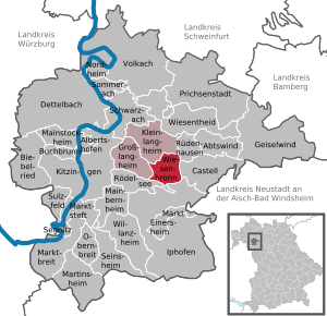
| Location of the municipality of Wiesenbronn in the Kitzingen district | ||
  |
||


Wiesenbronn is a municipality in the Lower Franconian district of Kitzingen , which is particularly known for its viticulture . The place is in the Steigerwald foreland at the foot of the Schwanberg and is a member of the Großlangheim administrative association .
geography
Wiesenbronn belongs to the Würzburg region (Bavarian planning region 2). There is only the Wiesenbronn district . Neighboring communities are Kleinlangheim , Rüdenhausen , Castell , Iphofen , Rödelsee and Großlangheim, starting from the north and clockwise .
The Dürrbach desert is located in the district of Wiesenbronn. The village was inhabited until the beginning of the 15th century. Several attempts at resettlement subsequently failed.
Wiesenbronn is naturally located in the Schwanberg foreland , part of the Steigerwald foreland. The landscape is characterized by smaller hills, their height increases in the direction of the Steigerwald.
The Franconian Marienweg runs through the village .
history
Until the church is planted
Around 800, "Wisibrunnen" was first mentioned in a document about a donation to the Fulda monastery.
For a long time it was assumed that the Megingaudeshausen monastery was founded in 816 near Wiesenbronn. The abbey is said to have stood in Ipfigau on the Mecken, above the Leimbach. Point to a location near the Koboldsee of Wiesenbronns:
- a hill called Meggen,
- the neighboring valley Goutsgrom (colloquially God's ditch or Gutsgraben),
- the Wiesbach, formerly Leimbach
- Heeresstraße, "Straße nach dem Steigerwald", along the Leimbach,
- the old field name Dietrichsau (memory of the first abbot Theotgar or Teutgar),
- Wiesenbronn field and settlement names such as Hardt, Hohefeld, Bernbuch or Wisibrunn in connection with Megingaudeshausen.
In 877 the monastery was closed and the Benedictines moved to the orphaned empire monastery of the Carolingians in Schwarzach . More recent research is moving the abbey to Oberlaimbach in Middle Franconia or to Ullstadt .
The history of Wiesenbronn focuses on three manors, the castle, the Fuchs'schen and the Castell'schen Burgstall . The eventful past of the place certainly contributed to the fact that none of these buildings is left. Not even the exact location of the castle stables is known. The Castell'sche ministerial family that settled there called themselves "Lords of Wiesenbronn ". Arnolt von Wiesenbrunn probably built the moated castle around 1200 in the absence of a mountain . The protection consisted of a double wall, a deep moat and a drawbridge . "In 1244 the knight Ulricus de Wisenbrunnen appears for the first time in the entourage of Count Friedrich I. zu Castell, and in 1268 the brothers Ulrich and Heinrich von ... Wisintbronnen ... certify a sales document of Count Hermann II. Zu Castell as a 'knight'". 1330 one can document documentary proof of settled gentlemen from Seinsheim in the place. They had received the Wiesenbronn Castle as a fief from the Margrave of Brandenburg.
The Castell'sche Burgstall was first mentioned in 1384 when Hans Pfaff von Seckendorf received it and the associated possessions from the Counts of Castell as a fief. The timber right from the community forest that rested on it suggests a longer existence. In 1420, Erkinger von Seinsheim, the owner of the castle, severely damaged the wall of Jakob von Seckendorf's castle stables and destroyed several subjects. From 1504, Burkhardt and Jörg von Gnottstadt owned “the desert and uncompromised dwelling” and the associated possessions. This line died out in 1533 and "Eilf subject goods along with the area of a former castle" came into the possession of Castell.
The rule of the von Seinsheim expired in 1516. Around 1517, under Philipp Esel zu Altenschönbach, the former moated castle and the stone castle stables “together with the castle” must have been reunited. Schübel explains this as follows: "When the castle that stood on the area of today's dairy gradually fell, another castle was built right next to it, which over time passed into other hands, while the property remained with the castle stables." In 1521 Wilhelm Fuchs von Dornheim received the Altenschönbacher possessions in Wiesenbronn from the margrave as a fief . Under the rule of Fuchs, the castle was completely destroyed in the Peasants' War. Fuchs von Dornheim had it rebuilt, as indicated by the years “1538” and “1539” in a window frame above the entrance. In 1546 Conrad von Castell bought the castle in Wiesenbronn from Valentin Fuchs, the brother of Fuchs von Dornheim. After 1577 it came into the possession of Count Heinrich. This brother of Conrad rebuilt it and immortalized himself with his wife through the coat of arms and the year "1579" in the door frame. The stone is still preserved in the house of the former Meierhof . When Heinrich died, most of the fiefdoms returned to the Castell-Rüdenhausen line. The castle suffered in the turmoil of the Thirty Years' War. Only Countess Luise Juliana and her brother Count Heinrich Albrecht lived there until 1687. That year the Countess was buried in the village. The Wiesenbronn Castle was rented out several times, sold in a rather dilapidated state and bought back again in 1838 by the Rüdenhäuser Line. In the course of the land consolidation (1964–1973), Prince Castell-Rüdenhausen moved his property to the Rüdenhäuser district and sold the buildings to farmers from Wiesenbronn. The castle had to be demolished in the middle of the 20th century.
Wiesenbronn was ruled in the condominium by the Grafschaft Castell , the Hochstift Würzburg and the Principality of Ansbach until it fell to the Kingdom of Bavaria in 1806 . When the area was cleared, it came to the Grand Duchy of Würzburg in 1810 and returned to Bavaria with it in 1814. In the course of the administrative reforms in Bavaria, today's municipality was created with the municipal edict of 1818 .
Population development
- 1970: 862 inhabitants
- 1987: 848 inhabitants
- 1991: 878 inhabitants
- 1995: 895 inhabitants
- 2000: 938 inhabitants
- 2005: 960 inhabitants
- 2010: 967 inhabitants
- 2015: 1052 inhabitants
politics
mayor
Volkhard Warmdt (Wiesenbronn citizens' list) has been the mayor since May 1, 2020. He was elected on March 15, 2020 with 61.4% of the vote. His predecessor was Doris Paul (list for Wiesenbronn), in office from May 2008 to April 2020.
coat of arms
|
|
Blazon : “In silver on a green lawn, a bricked black draw well with a black and silver tiled and two gold knobs provided hipped roof on two black pillars; a red bucket on a black chain. " |
| Justification for the coat of arms: The draw well refers to the place name. The tinging symbolizes the three village lords of the Prince-Bishops of Würzburg (red-silver), the Margraves of Brandenburg-Ansbach (black-silver) and the Counts of Castell (red-silver). |
Economy and Infrastructure
Economy including agriculture and forestry
In 1998, according to official statistics, there were no employees at the place of work in the manufacturing industry 73 or in the trade and transport sector. In other economic areas, 18 people were employed at the place of work subject to social security contributions. A total of 314 employees at the place of residence were registered. There were three companies in the manufacturing sector. In 1999 there were 49 agricultural holdings with an agricultural area of 775 hectares, of which 628 were arable land and 85 were permanent green areas. There is also a branch of the Raiffeisenbank Volkacher Mainschleife - Wiesentheid .
education
The following institutions exist (as of 2008):
- 50 kindergarten places with 36 children (sponsor: Evangelical Kindergarten Association)
- LeichterLernen-Institutes: learning strategies for schoolchildren, active learning support in schools, school development
- Conference and overnight accommodation of the Protestant rural youth: youth work and adult education (provider: Evangelical rural youth in Bavaria)
Culture and sights
Architectural monuments
church

The church of the Holy Cross dominates the townscape from its elevated position. The still clearly visible walling from the entrance to the village and the fortified northern wall point to the past as a refugee and church castle. The nave was rebuilt in 1603, which is reminiscent of the plaque on the column in front of the altar and a wooden pillar in the gallery. It was not until 1972 that frescoes were discovered and exposed.
graveyard


A cemetery with a free-standing sermon pulpit and arcade can also be found in Mainbernheim , Prichsenstadt , Repperndorf , Marktsteft and Abtswind . In 1603 the cemetery , which was inside the fortified church, was relocated to the edge of the village when the church was rebuilt. The spirit of the Reformation found its structural expression in the relocation. Before the Reformation, in the immediate vicinity of the holy of holies , the altar, and in the consecrated churchyard, one saw a claim to the redemption of the deceased at the resurrection. Outside the churchyard walls, outcasts found their place in unconsecrated earth. The Reformation changed that fundamentally. Believers relied on the saving suffering and death of Christ for each individual.
When it was redesigned at the end of the 20th century, the cemetery pulpit was moved from its location near the funeral hall to its current location so that the arcades can be used.
synagogue
In Wiesenbronn, 1548 Jews can be identified for the first time. In 1718 an extension on the property at today's Badergasse 4 could be used as a synagogue. The Jewish residents built the new synagogue there in 1792. There was also a Jewish school and a ritual immersion bath in Wiesenbronn . The dead found their final resting place in the Rödelsee cemetery.
The community had its heyday in the first half of the 19th century with 192 Jewish inhabitants in 1814 and the maximum number of 160 in 1837. In 1933, only 22 Jews lived in the village. During the November pogrom in 1938, Jewish residents were humiliated and mistreated. The last Jewish women were brought from Würzburg to Izbica near Lublin on March 24, 1943 and to Auschwitz on June 17, 1943 , and murdered.
After buying the building in 2005, the current owners renovated the former synagogue at Badergasse 4 in Wiesenbronn. During the renovation work, the remains of a demolished medieval mansion were discovered on which the current building was built.
town hall

The town hall was built in 1724 and the outside staircase in 1768. Above the clock are the professions of farmer and hacker, who shape and shape the village, with their tools, karst and pitchforks. Every hour they hit each other and point out previous conflicts between their professional groups.
Regular events
- Wine tasting in the Seegarten on the last Sunday in May
- Wine festival in the Seegarten on the first weekend in August
- Blessing of the grapes on the first Sunday of September
- Shooting festival with riflemen and a cozy get-together on the second Sunday in September
- Parish fair on the fourth Sunday in September
- Citizens' excerpt on the Tuesday of the Kirchweih
- The last load is collected on the third Sunday in October
legend
The leprechaun
The Wiesenbronner Koboldstraße and the so-called Koboldsee in the southeast of the village point to the most famous legend of the village. In front of the village, in the Allern corridor, a goblin was once up to mischief. He stole the tools of the farmers, the bread from the field workers and destroyed a plow . He was also held responsible for the cows' lack of milk. He is said to have kicked her udders .
He annoyed the goose herders on the Allern by driving their animals apart with loud shouts. The news of the goblin quickly spread in the village and the land was avoided. Only one poor farmer had to visit his small field on the Allern every day. Once he took his wife and child with him, who were carried in a small wicker basket . The goblin crept to the basket, carried the child away, and sat in it himself.
When the woman wanted to check on her son, the crab-red goblin looked at her. The woman was so frightened that she dropped dead. The farmer could run into the village and call the monks of the nearby monastery. They went up the Allern in a great procession. The abbot raised the cross in front of the changeling in the basket and the goblin ran screaming into the nearby forest. Nobody had to suffer from his pranks anymore. The forest, however, was called "Lachwald" and should be avoided on Walpurgi Day.
The Huppmann
The district of Wiesenbronn has always been controversial in the past. The Iphöfer in particular often tried to move their borders at the expense of the Wiesenbronners. The Wiesenbronners claimed that the border ran over the Sattlesrangen parcel , while the Iphöfer identified the Zerchweg as the actual border area. An Iphöfer forest ranger swore: "As true as the Creator is above me, I stand on Iphöfer earth ." The area fell to Iphofen.
The forest ranger had, however, put a ladle in his hat and was standing in his shoes on earth from Iphofen. When he died, he had to pay for his betrayal and act as a ghost. With the call: "Hupp, he-i!", He caused fear and horror. Sometimes you threatened naughty children with the so-called Huppmann. The forest ranger was probably released one day because his shouting stopped at some point.
Viticulture

As long as the history of Wiesenbronn can be traced back, there was viticulture in the place . In 1883 120.08 hectares of 1057.97 hectares of the commercially used area were planted with vines. The custom of real division resulted in more and more properties and an ever smaller parcelling developed . A picturesque, varied landscape with large, dense hedges, meadows, fields and small vineyards grew. Their appearance was characterized by the curved lines, the narrow, irregularly growing, low vines and the vineyard houses. The variety of site names was great: Obere Hardt, Kiliansberg, Hirschgraben, Dürrbach, Hägel, Bernbuch, Rödelseer Weg, Hasenberg, Sändlein, Höll, Schleifweg, Würmlein, Damm, Kirchbühl, Rüdenhäuser Weg, Saubuck, Roßbach, Trautberger Weg, Rosenbühl, Casteller Weg, Königlein, Dietrichsau, Lötschen, Mecken, Schiller, Höhfeld, Gans, Kobold, Desen, Hellenberg, Klingenweg, Knorrn, Hölzlein, Geisberg, Kugelspiel and Eichelsee.
In order to make agriculture crisis-proof and competitive, it had to be rationalized. Land consolidations were carried out systematically. At the end of the land consolidation in 1973 there was still 48.38 hectares of vineyards of 1127.24 hectares of agricultural land. Of the old site names, only two big ones prevailed: Geisberg and Wachhügel. All newly created vineyards now had a uniform appearance thanks to the line spacing of 1.50 m and the planting spacing of 1.30 m.
Red wine has been grown in the Wiesenbronn area since 1947. As a result of this, as well as the outstanding quality of its wines, the climate and soil-friendly place became known as the “red wine island on the Steigerwald”. 1974 pioneering winemakers in Wiesenbronn started organic viticulture.
Today there are a total of three vineyards around the village, the wine is marketed under the names Wiesenbronner Geißberg, Heller Berg and Wachhügel. The Wiesenbronner Kirchbühl is not an official location. Wiesenbronn is part of the Schwanberger Land area, until 2017 the winemakers were grouped together in the Steigerwald area. The Keuperböden around Wiesenbronn are just as suitable for growing wine as the location in the Maingau climate zone, which is one of the warmest in Germany. The centuries-old wine culture also attracts tourists to Wiesenbronn. A wine labyrinth was created and artists were hired to set up a wine art trail.
| Vineyard | Size 1993 | Size 2019 | Compass direction | Slope | Main grape varieties | Great location |
|---|---|---|---|---|---|---|
| Geissberg | 18 ha | 10 ha | southwest | 25% | Silvaner | Rödelsee Castle Hill |
| Light mountain | not clear | 4 ha | Southwest, south | not clear | not clear | Rödelsee Castle Hill |
| Guard hill | 50 ha | 37 ha | Northwest | 10% | Silvaner , Müller-Thurgau | Rödelsee Castle Hill |
Personalities
- Heinrich Ritter von Buz (1801–1876), Lieutenant General, Chief of the Bavarian Engineer Corps
- Carl Buz (1803–1870), industrialist
- Seligmann Bär Bamberger , the "Würzburger Rav" (1807–1878), an important representative of Orthodox Judaism, was born at Eichenstrasse 1 in Wiesenbronn. The house no longer stands. A plaque commemorates this famous son of the community.
- Gerd Landsberg (* 1952), executive member of the presidency of the German Association of Towns and Municipalities , was born in the municipality.
literature
- Hans Ambrosi, Bernhard Breuer: German Vinothek: Franconia. Guide to the vineyards, winegrowers and their kitchens . Herford 2 1993.
- Hans Bauer: Old and new coats of arms in the Kitzingen district . In: Yearbook of the district of Kitzingen 1980. In the spell of the Schwanberg . Kitzingen 1980. pp. 53-70.
- Jesko Graf zu Dohna (Ed.): In the footsteps of the Counts of Castell . Four towers, Benedict Press, Münsterschwarzach 2004.
- Johann Ludwig Klarmann: The Steigerwald in the past. A contribution to Franconian cultural studies . Gerolzhofen 2 1909.
- Johann Ludwig Klarmann, Karl Spiegel: Legends and sketches from the Steigerwald. Reprint of the 1912 edition . Neustadt an der Aisch 1982.
- Theophil Steinbrenner, Gerhard Wahler, Auguste Steinberger, Felix von Fokczynski (eds.): Intermediate lights. Traditional stories from the old county of Castell . Albertshofen² 1979.
Web links
- Entry on the coat of arms of Wiesenbronn in the database of the House of Bavarian History
Individual evidence
- ↑ "Data 2" sheet, Statistical Report A1200C 202041 Population of the municipalities, districts and administrative districts 1st quarter 2020 (population based on the 2011 census) ( help ).
- ↑ Jesko Graf zu Dohna (Ed.): In the footsteps of the Counts of Castell . Four towers, Benedict Press, Münsterschwarzach 2004, p. 20 .
- ↑ Georg Spath: History of the Schwanberg and its neighborhood . Scheinfeld 1934, p. 57-61 .
- ↑ a b c d e f g h i j k l Albert Schübel: The castle and the two castle stables in Wiesenbronn along with relevant news . In: Record of the history of the community of Wiesenbronn . Kitzingen April 2nd, 1957.
- ↑ In the footsteps of the Counts of Castell, p. 20.
- ↑ Princely Castell's Archive CI c 3
- ↑ In the footsteps of the Counts of Castell, p. 21
- ↑ Michael Hofmann, local representative of the land consolidation community, Schulgasse 1, Wiesenbronn
- ^ Bauer, Hans: Old and new coats of arms in the district of Kitzingen . P. 69.
- ^ Rosmarie Hofmann, Church of the Holy Cross in Wiesenbronn, Festschrift for the 400th anniversary of the parish fair, 2003, p. 5
- ↑ Bettina Vaupel: The unpainted corner. Impressive initiative for the former synagogue in Wiesenbronn . In: Monumente , vol. 24 (2014), issue 6, p. 29.
- ^ Wiesenbronn (VG Großlangheim, Kitzingen district) Jewish history / synagogue. May 7, 2012. Retrieved September 27, 2012 .
- ↑ Steinbrenner, Theophil (ed. And others): Zwischenlichten . P. 43 f.
- ↑ Klarmann, Johann Ludwig (among others): Legends and sketches from the Steigerwald . P. 261.
- ↑ a b Land use surveys by the Bavarian State Statistical Office, Wiesenbronn municipal archive
- ↑ Barbara Meuschel: Vineyard names in the Kitzingen district . Würzburg May 9, 1975, p. 93−97 .
- ^ Hans Gamperl: Land consolidation and nature conservation . Bayerischer Landwirtschaftsverlag, Munich 1952, p. 3 .
- ^ Ambrosi, Hans (among others): German Vinothek: Franconia . Pp. 50-52.
- ^ Government of Lower Franconia: Vineyards in Bavaria broken down by area , PDF file, accessed on May 16, 2019.
- ^ Ambrosi, Hans (among others): German Vinothek: Franconia . P. 237.
- ↑ Klarmann, Johann Ludwig: The Steigerwald in the past . P. 215.

Cities: Dettelbach | Iphofen | Kitzingen | Mainbernheim | Market wide | Marktsteft | Prichsenstadt | Volkach
Markets: Abtswind | Hostage wind | Großlangheim | Kleinlangheim | Einersheim Market | Obernbreit | Rüdenhausen | Schwarzach am Main | Home of being | Wiesentheid | Willanzheim
Municipalities: Albertshofen | Biebelried | Buchbrunn | Castell | Mainstockheim | Martinsheim | Nordheim am Main | Rödelsee | Segnitz | Sommerach | Sulzfeld am Main | Wiesenbronn