Schwanbergvorland
| Schwanbergvorland | |||
|---|---|---|---|
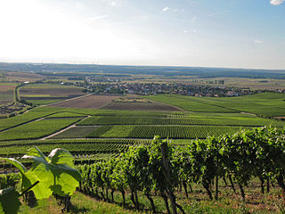
| The Schwanberg foreland near Rödelsee. The rise in the area towards Steigerwald is clearly visible | |||
| Systematics according to | Handbook of the natural spatial structure of Germany | ||
| Greater region 1st order | Layer level land on both sides of the Upper Rhine Rift | ||
| Greater region 2nd order | Southwest German layer level country | ||
| Greater region 3rd order | Swabian-Franconian Gau | ||
| Main unit group | 13 → Main Franconian plates |
||
| About main unit | 137 → Steigerwald foreland |
||
| 4th order region (main unit) |
137.1 → Iphofen-Gerolzhofener Steigerwaldvorland |
||
| Natural space |
137.11 → Schwanberg foreland |
||
| Natural area characteristics | |||
| Landscape type | hilly foot region of the Schwanberg step | ||
| Geographical location | |||
| Coordinates | 49 ° 44 '31.8 " N , 10 ° 17' 27.3" E | ||
|
|||
| local community | Markt Einersheim , Iphofen , Rödelsee , Wiesenbronn , Wiesentheid | ||
| circle | Kitzingen district | ||
| state | Bavaria | ||
| Country | Germany | ||
The Schwanberg foreland is a small-scale natural space unit (5th order) with the order number 137.11 around Iphofen , Rödelsee and Wiesenbronn in the Lower Franconian district of Kitzingen .
location
The Schwanbergvorland (137.11) forms a sub-unit within the main unit Iphofen-Gerolzhofener Steigerwaldvorland (137.1). It is part of the Steigerwald foreland (137) and thus a natural area in the main unit group of the Mainfränkische Platten . In the north, the area is bounded by the Dimbacher drift sand area (137.02), which is part of the Kitzinger Mainebene (137.0), which is closer to the Main . The entire west is already occupied by the Northern Steigerwald (115.0) with the Schwanberg subunit (115.00). Hellmitzheim Bay (137.10) joins in the south . Other natural areas in the east are the Mainbernheimer level (137.00) and the Albertshofener drift sand area (137.01).
The natural area stretches in an approximately 2 to 5 km narrow strip in an arc around the eponymous Schwanberg, which marks the westernmost foothills of the Steigerwald. The exact extent is unclear due to the lack of cartographic documentation of the area around Bamberg . The northernmost district is probably that of the Wiesentheider district of Feuerbach . The area includes the districts of Wiesenbronn, Rödelsee and the city of Iphofen. In the south, the area around Possenheim forms the end. The Würzburg-Nuremberg railway line in the south cuts through the natural area.
Landscape characteristics
The landscape of the natural area presents itself as a hilly foot region that rises gently to moderately sloping up to the Schwanberg. The slope angles in the direction of the mountain increase from 3 to 15 °. The natural space mediates between the almost level gullies and the rise of the terrain in the direction of the Steigerwald. The few rivers that flow from the Steigerwald here have not been able to develop deep valleys.
The landscape has been shaped by human work for centuries. However, the soils are not designed for intensive agricultural use, but tend to be rinsed off heavily. Nevertheless, arable farming is practiced here, fruit-growing still widespread further west hardly exists. Instead, the slopes in the direction of the Steigerwald partly bear grapevines. Gypsum processing companies are also located here. The potential natural vegetation (without human intervention) would produce extensive alluvial forests here , only along the streams would spruce be found, the ascent towards the Schwanberg would be covered with oaks and firs .
Protected areas
In contrast to the areas along the Main and in the Steigerwald, only a few protected areas have been designated in the Schwanberg foreland. To the north of Rödelsee, only an extensive bird sanctuary in the southern Steigerwald protrudes into the natural area. A fauna and flora habitat can be found south of Possenheim that protects the gypsum karst springs.
Climate, geology and tectonics
Unlike many neighboring areas, the Schwanberg foreland is not so low in precipitation. This is due to a so-called precipitation road that extends from Ochsenfurt over the Mainbernheimer level and the Hellmitzheimer Bucht to the Schwanberg. At the same time, there is a high risk of frost in spring, especially in the shady valleys, which means restrictions on agricultural use.
Geologically mediates the area to the Keuperstufe. On the surface, soils of the Lower Keuper with its border dolomites and Latvians predominate ; after the ascent towards Steigerwald, gypsum keuper soils can also be found. The soils are very poor in humus and rich in silt stones , which can lead to rinsing after even smaller rainfall.
See also
literature
- Karl-Albert Habbe: The natural space units on sheet 153 Bamberg 1: 200,000 - A bundle of problems and a suggested structure. In: Mitteilungen der Fränkische Geographische Gesellschaft Vol. 50/51 for 2003/2004 . Erlangen 2004. pp. 55-102.
- Horst Mensching, Günter Wagner: The natural spatial units on sheet 152 Würzburg (= geographical land survey 1: 200,000 natural spatial structure of Germany) . Bad Godesberg 1963.
Web links
Individual evidence
- ↑ Geography Giersbeck: Map 152 Würzburg , PDF file, accessed on 5 February of 2019.
- ↑ Mensching, Horst (among others): The natural space units on sheet 152 Würzburg . P. 34.
- ^ Habbe, Karl-Albert: The natural space units on sheet 153 Bamberg 1: 200,000 . P. 85 (map).
- ↑ Mensching, Horst (among others): The natural space units on sheet 152 Würzburg . P. 34.

