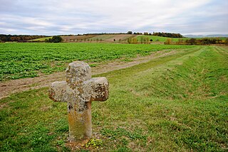
Dimbacher drift sand area
| Dimbacher drift sand area | |||
|---|---|---|---|
| The Dimbach drifting sand area on the border between the districts of Dimbach and Gerlachshausen, which is already in the shallower Schwarzacher basin | |||
| Systematics according to | Handbook of the natural spatial structure of Germany | ||
| Greater region 1st order | Layer level land on both sides of the Upper Rhine Rift | ||
| Greater region 2nd order | Southwest German layer level country | ||
| Greater region 3rd order | Swabian-Franconian Gau | ||
| Main unit group | 13 → Main Franconian plates |
||
| About main unit | 137 → Steigerwald foreland |
||
| 4th order region (main unit) |
137.0 → Kitzinger Main Plain |
||
| Natural space |
137.02 → Dimbacher drift sand area |
||
| Natural area characteristics | |||
| Landscape type | Sand and Lettenkeupere plains, deciduous and coniferous forests | ||
| Geographical location | |||
| Coordinates | 49 ° 50 '15.4 " N , 10 ° 13' 57.5" E | ||
|
|||
| Local area | Dimbach , Hallburg , Nordheim am Main , Reupelsdorf , Sommerach | ||
| local community | Nordheim am Main , Sommerach , Volkach , Wiesentheid | ||
| circle | Kitzingen district | ||
| state | Bavaria | ||
| Country | Germany | ||
The Dimbacher drift sand area is a small-scale natural spatial unit (5th order) with the ordinal number 137.02 in the area of the Lower Franconian communities of Nordheim am Main , Sommerach , Volkach and Wiesentheid in the Kitzingen district .
location
The Dimbacher drift sand area (137.02) forms a sub-unit within the main unit of the Kitzinger Main Plain (137.0). It is part of the Steigerwald foreland (137) and thus a natural area in the main unit group of the Mainfränkische Platten . The natural area protrudes in a wide strip from the northwest into the Middle Main Valley (133), subunit Volkacher Mainschleife (133.07). In the north the area is bounded by the Steigerwald foreland of Neuses (137.12), to the south-east the Schwanberg foreland (137.11) can be found. To the south-east, the natural spatial unit merges into the closely related Albertshofener drift sand area (137.01), to the west lies the Schwarzacher valley widening (133.06).
The natural area is located in the northwest of the Lower Franconian district of Kitzingen. It includes areas in the communities of Sommerach, Nordheim am Main, Volkach and Wiesentheid. The center is the place Dimbach , which is a part of Volkach. Reupelsdorf can be found southeast of this . The Volkach district of Hallburg is also located within the subunit. The western part protrudes onto the so-called Weininsel with the districts of Nordheim am Main and Sommerach. The so-called Main Canal Volkach-Gerlachshausen cuts through the Dimbacher drift sand area. In the extreme south-east and in the center of the natural area there are also extensive forest areas.
Landscape characteristics
The drifting sand surface presents itself as an undulating sand and Lettenkeupere plane south of the city of Volkach. Extensive deciduous and coniferous forests can be found in the eastern part of the unit. Further to the south, the Albertshofener drifting sand area joins, which has relatively similar landscapes. It is, however, much less hilly because the Dimbacher drift sand area is to be found above the erosion base of the Main . At the same time, certification is more pronounced here.
Extensive forest areas can be found in the north ( Hartwald ), south (Spessart) and southeast (Reupelsdorfer Staatswald). Agricultural double crops predominate, e.g. B. plum cultivation on small plots. Only in the far west on the Weininsel are vineyards around the highest elevation, the Rosenberg. The potential, natural vegetation here would include chickweed , oaks, hornbeams in extensive forests and be interspersed with pure bedstraw .
Protected areas
The natural spatial unit is interspersed with protected areas of almost every protection category. So parts of the conservation area, to find Volkacher Mainschleife in the far west. Above all, the bush and forest areas are registered bird sanctuaries as a retreat for birds as part of the southern Steigerwald foreland. The only nature reserve are the sand meadows near Volkach, Schwarzach am Main and Sommerach .
Geology and tectonics
The soils in the drift sand area are dominated by thick, loamy sand covers . The documents consist largely of the Lettenkeuper. The eastern part of the subunit is dominated by drifting sands, here there are clayey loam soils based on Lettenkeuper. The Main Canal today cuts through an old Quaternary valley.
See also
literature
- Karl-Albert Habbe: The natural space units on sheet 153 Bamberg 1: 200,000 - A bundle of problems and a suggested structure. In: Mitteilungen der Fränkische Geographische Gesellschaft Vol. 50/51 for 2003/2004 . Erlangen 2004. pp. 55-102.
- Horst Mensching, Günter Wagner: The natural spatial units on sheet 152 Würzburg (= geographical land survey 1: 200,000 natural spatial structure of Germany) . Bad Godesberg 1963.
Web links
Individual evidence
- ↑ Geography Giersbeck: Map 152 Würzburg , PDF file, accessed on January 8, 2019.
- ↑ Mensching, Horst (among others): The natural space units on sheet 152 Würzburg . P. 33.
- ^ Habbe, Karl-Albert: The natural space units on sheet 153 Bamberg 1: 200,000 . P. 85 (map).
- ↑ Mensching, Horst (among others): The natural space units on sheet 152 Würzburg . P. 33.

