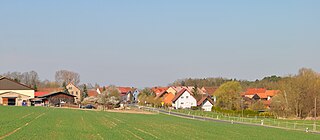
Albertshofener drift sand area
| Albertshofener drift sand area | |||
|---|---|---|---|
| Atzhausen in the flat drifting sand area | |||
| Systematics according to | Handbook of the natural spatial structure of Germany | ||
| Greater region 1st order | Layer level land on both sides of the Upper Rhine Rift | ||
| Greater region 2nd order | Southwest German layer level country | ||
| Greater region 3rd order | Swabian-Franconian Gau | ||
| Main unit group | 13 → Main Franconian plates |
||
| About main unit | 137 → Steigerwald foreland |
||
| 4th order region (main unit) |
137.0 → Kitzinger Main Plain |
||
| Natural space |
137.01 → Albertshofener drift sand area |
||
| Natural area characteristics | |||
| Landscape type | Sand plain, mixed oak forests | ||
| Geographical location | |||
| Coordinates | 49 ° 46 '8.9 " N , 10 ° 15' 53.7" E | ||
|
|||
| Local area | Albertshofen , Atzhausen , Feuerbach , Haidt , Kitzingen , Kleinlangheim | ||
| local community | Albertshofen , Kitzingen , Kleinlangheim , Wiesentheid | ||
| circle | Kitzingen district | ||
| state | Bavaria | ||
| Country | Germany | ||
The Albertshofener drifting sand area is a small-scale natural spatial unit (5th order) with the order number 137.01 in the Lower Franconian communities of Albertshofen , Kitzingen , Kleinlangheim and Wiesentheid in the Kitzingen district.
location
The Albertshofener drift sand area (137.01) forms a sub-unit within the main unit of the Kitzinger Mainebene (137.0). It is part of the Steigerwald foreland (137) and thus a natural area in the main unit group of the Mainfränkische Platten . The natural area is bounded in the north by the Schwarzacher valley widening (133.06), which is part of the Middle Main valley (133). To the northeast is the very similar landscape of Dimbacher drift sand area (137.02). In the east, the landscape rises towards the Schwanberg foreland (137.11). The south is occupied by the Mainbernheimer level (137.00), while the Main flows in the west in the Kitzinger Main valley (133.05).
The natural area is located in the northwest of the Lower Franconian district of Kitzingen. It includes areas in the communities of Albertshofen, Kitzingen, Kleinlangheim and Wiesentheid. The eponymous place Albertshofen lies on the edge of the natural area, the center is formed by the large forest areas north of Kitzingen. The northern end today is the federal motorway 3 with the Haidt service area . In the northeast, the Sambach between Atzhausen and Feuerbach closes the area.
Landscape characteristics
The Albertshofener drifting sand area is a sand plain with mixed oak forests. It differs from the more southerly Mainbernheim level in the wider distribution of these sand levels. The plains are mostly not hilly and, due to their higher position above the Main, are only slightly eroded. The area is characterized by two large forest areas. The Klosterforst is a state forest, the Gültholz a Rechtlerwald . The landscape delimitation to the Schwanberg foreland is hardly noticeable.
In addition to the forests, large areas with field vegetable crops occupy the natural space. The potential natural vegetation (without human intervention) would include extensive forests with chickweed, oaks and hornbeams interspersed with pure bedstraw .
Protected areas
Large parts of the natural space contain protected areas of almost every protection category with large forest areas at the center. A large area is taken up by the bird sanctuary southern Steigerwaldvorland, the fauna-flora habitat puts the drifting sand areas under protection. The nature reserves Sande am Tannenbusch near Kleinlangheim , Belkers near Großlangheim and Kranzer enjoy special protection .
Geology and tectonics
The majority of the soils in the Albertshofener drifting sand area take up dune or drifting sands . In places the sand deposits are relatively small, so that other soils could form above the clayey Lettenkeuper . In the forests in particular, waterlogging zones and bog soils developed.
See also
literature
- Karl-Albert Habbe: The natural space units on sheet 153 Bamberg 1: 200,000 - A bundle of problems and a suggested structure. In: Mitteilungen der Fränkische Geographische Gesellschaft Vol. 50/51 for 2003/2004 . Erlangen 2004. pp. 55-102.
- Horst Mensching, Günter Wagner: The natural spatial units on sheet 152 Würzburg (= geographical land survey 1: 200,000 natural spatial structure of Germany) . Bad Godesberg 1963.
Web links
Individual evidence
- ↑ Geography Giersbeck: Map 152 Würzburg , PDF file, accessed on January 8, 2019.
- ↑ Mensching, Horst (among others): The natural space units on sheet 152 Würzburg . P. 32.
- ^ Habbe, Karl-Albert: The natural space units on sheet 153 Bamberg 1: 200,000 . P. 85 (map).
- ↑ Mensching, Horst (among others): The natural space units on sheet 152 Würzburg . P. 32 f.

