Haidt (Kleinlangheim)
|
Haidt
Kleinlangheim market
Coordinates: 49 ° 46 ′ 57 ″ N , 10 ° 15 ′ 22 ″ E
|
|
|---|---|
| Height : | 212-228 m |
| Residents : | 90 |
| Incorporation : | January 1, 1978 |
| Postal code : | 97355 |
| Area code : | 09325 |
|
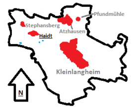
Location of Haidt (bold) in the municipality of Kleinlangheim
|
|
Haidt is a district of the Kleinlangheim market in the Lower Franconian district of Kitzingen .
Geographical location
Haidt is located in the north-west of the municipality of Kleinlangheim. In the north, the municipality of Schwarzach am Main begins with Düllstadt . Atzhausen is to the northeast , while Kleinlangheim is to the southeast. Großlangheim is located to the south and Hörblach , also a district of Schwarzach, connects to the west .
The closest larger cities are Volkach, about 9 kilometers away, and Kitzingen , about 8 kilometers away.
history
In 788, "Heyde", as it was called at the time, was first mentioned in the sources. The name of the place goes back to the location on the high terrace of the Main. The speaking name refers to the nearby heathland. Haidt was on the old Heerweg between Würzburg and the Cistercian monastery in Ebrach. At the end of the Middle Ages, the village came into the possession of the Ansbach margraves in 1502 .
Together with the hamlet of Stephansberg, Haidt formed a small community up to 1978; with the new communal organization, it was integrated into the newly created community of Kleinlangheim.
Attractions
Haidt has a typical Franconian farmhouse from the early 19th century as a monument worth seeing.
literature
- Hans Bauer: District of Kitzingen. An art and culture guide . Market wide 1993.
- FG: Haidt . In: 1875–1985. 110 years of the Haidt-Stephansberg volunteer fire department. Holidays from July 6th to 7th, 1985 . Haidt 1985. p. 13.


