
Düllstadt
|
Düllstadt
Schwarzach am Main market
Coordinates: 49 ° 48 ′ 8 ″ N , 10 ° 15 ′ 9 ″ E
|
|
|---|---|
| Height : | 201 m |
| Area : | 5.18 km² |
| Residents : | 276 (2018) |
| Population density : | 53 inhabitants / km² |
| Incorporation : | 1st October 1973 |
| Postal code : | 97359 |
| Area code : | 09324 |
 Location of Düllstadt (bold) within the Schwarzach municipality
|
|
 |
|
Düllstadt is a district of the market Schwarzach am Main in the Lower Franconian district of Kitzingen in Bavaria. Düllstadt was an independent municipality until it merged with five other places in the 1970s. The development of the village is closely linked to the nearby Münsterschwarzach monastery , which ran a sheep farm in Düllstadt. The connections to the monastery were not destroyed until the transition to Bavaria at the beginning of the 19th century.
Today Düllstadt is the smallest of the Schwarzach districts and, unlike the other villages, is not exclusively located in the Schwarzach basin . For a long time the village was dominated by agriculture , which today only plays a very minor role. Some buildings from the village's past have been preserved along federal road 22, which forms the through-town. The St. Michael branch church is particularly noteworthy.
Geographical location
Geography and natural location
Düllstadt lies in the east of the Schwarzach municipality. The urban area of Volkach begins some distance to the north, and the district of Dimbach is closest to Düllstadt. Further to the northeast is Reupelsdorf , which is now part of the municipality of Wiesentheid , the entire east is taken up by the Michelheidewald in Reupelsdorfer district. Kleinlangheim - Atzhausen can be found in the southeast . In contrast, Haidt in the south , which also belongs to Kleinlangheim, has no direct road connection . Stadtschwarzach and the other Schwarzach districts of Münsterschwarzach and Gerlachshausen, with which Düllstadt has almost grown together, extend to the west .
Closest, larger cities are Volkach , which is about 7 kilometers away, and Kitzingen , which is about 10 kilometers away. The next big city is Würzburg, about 23 kilometers away .
In terms of its natural surroundings, Düllstadt lies on the edge of the so-called Schwarzacher valley widening (also Schwarzacher basin). The section of the Middle Main Valley is characterized by its flat sections directly adjoining the Main. Here three streams with originally almost the same bed flow into the Main at a distance of only about 250 m, pushing flat alluvial fans in front of them. The valley widening is also densely populated because of its fertile soil. The eastern and southern parts of the district have a different soil composition and are therefore part of the extensive Albertshofener drifting sand area in the Steigerwald foreland .
The district is located in the Maingau climate zone, which is one of the driest and warmest climate zones in Germany. This also explains the viticulture in the area around Düllstadt. Geologically, Keuper rocks already predominate on the east side of the Main , which are already typical for the Steigerwald foreland and its natural areas. In contrast, drifting sand is particularly common in the south of the district, which is already rising towards the Steigerwald.
Düllstadt is dominated hydrologically by the Main , even if the settlement does not have its own access to the river. The Main flows past in the west about 2.5 kilometers away. The main tributary of the Castellbach , which flows through Düllstadt from the southwest and branches off here to form an unnamed Mühlbach, is particularly significant for the village . The Silberbach rises in the middle of the village. The Schwarzach plays a role for the northern district. It unites here with the Seeflußgraben, which flows into it from Eichfeld . The Wenzelbach flows through the extreme south of the district.
Village structure
The Düllstadt district covers an area of 5.1 km². Centrally located here is the built-up area with the street village divided in two by the Castellbach , which is crossed by today's federal road 22. The younger part of the village is in the northeast and is dominated by the church , the old school and the town hall , all of which were located north of the main street. The south-western part is older, where the estate that characterizes the town and refers to the rule of the Münsterschwarzach monks. The cemetery was laid out south of the courtyard in 1804.
New development areas surround the manor in particular . Initially, from the 1970s, people settled along Atzhäuser Strasse, which branches off from the main town, about 700 meters from the church. A large- scale nursery also settled here, which today is the only industrially used area that connects the town center and the houses on Atzhäuser Straße. In 1972, new areas were developed south of the estate with the Koppelwasen building area, which are directly adjacent to the old town. In 1995 this area was expanded to include the Ahornring.
The large district is characterized by different landscapes. A narrow wooded area , the so-called fir forest, stretches along the Castellbach almost into the village. Forest can also be found with the Axbach forest to the north of the church. Three lakes framing the new development areas one along the Atzhäuser street, right in the south, a large solar park covers. The so-called Wasenmeisterei am Seeflußgraben, on the other hand, is older and is located in the far north of the area on the edge of the Reupelsdorf Forest and is also surrounded by several lakes. Several trees registered as natural monuments are located near the church. The so-called Ludwigslinde in front of the former town hall is particularly important.
history
Prehistory and early history
The Schwarzach Basin has a long history of settlement that goes back to the Palaeolithic . 4000 years ago, corded ceramists from the Neolithic period settled in the area around Schwarzenau. The Urnfield period is represented by several finds around Hörblach. At the same time, the area around Düllstadt was opened up by people. In 1969 a conical neck vessel was discovered in the area surrounding the present-day settlement, which contained the cremated remains of a young man.
From the earlier Iron Age , partition wall shells of the Hallstatt people from the period between 800 and 500 BC have been preserved around Schwarzenau , which can be seen today in the Museum für Franken . Their grave goods were still made of bronze. Graves from the La Tène period have been identified around Gerlachshausen . The Celtic tribe of the Bojer established a permanent settlement in Schwarzenau around the turn of the ages. At the same time, Celtic finds were made on the other side of the Main .
The basin was then settled by Alemanni , who disappeared around AD 260. They made way for the Burgundians who settled between the Main and Schwarzach until the 4th century. These Germanic tribal associations also established the name Schwarzach for the flowing water in the center of the valley widening. From the 6th century onwards, Frankish tribes coming from the west began to penetrate the area and slowly displaced the established population.
At the time of the Franconian Merovingians in the 6th century, Düllstadt was also settled permanently. This is indicated by an area south of St. Michael's Church, which is now listed as a ground monument. The Franks brought Christianity with them to the Main and established the first administrative borders, the so-called Gaue . The later Düllstadt lay south of the Schwarzachbach and was thus part of the Iffgau.
middle Ages
There is disagreement in the literature about the first mention of Düllstadt. The village may already be found in a document in 815/816. The place is said to have belonged to the equipment of the Megingaudshausen monastery founded in the Steigerwald , which was a kind of predecessor institution of the abbey in Münsterschwarzach . However, this first mention as Ulgestat, to which the word Dülstat was added in a later copy, is controversial and is now being questioned in monastery research. However, local traditions still refer to this very early mention.
What is certain, however, is a mention of "Tullstatt" in a confirmation document from the year 918. On April 21, 918, King Konrad I confirmed several places in Frankfurt am Main that Bishop Dracholf von Freising, who was also abbot of Schwarzach, to his monastery had passed. About Düllstadt, Stadelschwarzach and Wiesentheid it is said that these places “ad victum et restitutum ipsorum fratrum pertinent (...)” (Latin for the livelihood and clothing of these monks).
Düllstadt was already closely connected to the neighboring monastery when it was first mentioned. Again it appeared in 1023 in the written sources, when Emperor Henry II. The Bishopric of Würzburg his Wildbann awarded in the Steigerwald. At that time the place probably consisted of a few houses grouped around a sheep farm that was assigned to the Münsterschwarzach monastery. The sources are silent about the lordship in the early days.
At the beginning of the 13th century, Düllstadt lost a large part of its municipal area because it was assigned to the newly founded city of Schwarzach. Around 1266 the small town was part of the extensive bailiwick holdings of the Counts of Castell , who tried to build a rulership between the Main and Steigerwald. They had the Bailiwick but by the powerful prince bishops of Würzburg fief received and were only allowed to sell them with their consent.
This happened in 1306 when the Münsterschwarzach monastery began to act as an independent power factor in the Schwarzach basin. Several bailiwicks over places around the abbey, including Düllstadt, came to the monastery through Bishop Andreas , which was to become the landlord of these villages. At the same time, the judicial integration of the village into the structures of the monastery property began, so in the Middle Ages and early modern times the Düllstadt residents had to go to the cloister court in Münsterschwarzach.
Similar to neighboring Stadtschwarzach, Düllstadt was drawn into the dispute between the Prince Bishopric of Würzburg and the Margrave of Ansbach Albrecht Achilles in the First Margrave War in 1461 . The Vogt of the margravial town of Kitzingen , Georg von Gebsattel, moved with his troops to Stadtschwarzach and set the more unprotected Düllstadt on fire. The sources are silent about the reconstruction of the place.
Early modern age
Occupations and looting also shaped the history of Düllstadt in the 16th century. The sheep farm in the center of the village, which is so important for the economy of the monastery, was repeatedly affected. On July 26th, 1546, during the Schmalkaldic War, Johann Friedrich I of Saxony and his troops robbed the village and had 750 sheep and pigs carried away. In the period that followed, the Düllstadt residents could no longer pay the grain tithing to the monastery.
A few years later the village was again polluted. In the Second Margrave War of Albrecht Alcibiades , the monastery villages were harassed. Although Sommerach in particular was affected by billeting in 1553, Düllstadt was weighed down with at least 500 guilders in contributions. A year later, the battle of Stadtschwarzach took place in the immediate vicinity of the village , which was one of the margrave's retreat battles .
Düllstadt was hit worse in the Thirty Years' War . The place became more and more deserted due to constant attacks and raids by the enemy troops. The monastery chronicler Burkard Bausch wrote about Düllstadt: “Since all the inhabitants, except for the last man, have left their homeland, foxes, rabbits etc. are at home here, who fearlessly set up their hiding places in the deserted houses.” At the end of the war the village of Düllstadt existed no more.
After the Peace of Westphalia and the end of the fighting in 1648, efforts were made in Münsterschwarzach to repopulate the village, which was an important cornerstone of the monastery rule. Abbots Benedict II. Weidenbusch and especially Plazidus Büchs promoted the resettlement of residents in Düllstadt. In 1688, the small village received a new center with the Michael's Church, which symbolized the completion of the reconstruction.
Modern times: In Bavaria
The secularization of the Münsterschwarzach monastery at the beginning of the 19th century meant a profound intervention in the economic and social structure of the Schwarzach basin. First the village came to the Electoral Palatinate of Bavaria in 1803 , later followed by an interim period in the Grand Duchy of Würzburg until 1814 . Only then did Düllstadt become a rural community in the Kingdom of Bavaria . The district court in nearby Volkach was responsible for Düllstadt. With that the village lost its historical connection to the places around the former monastery.

The monks, who had previously maintained their sheep farm in the village for centuries, ceased to be masters. The manor was privatized and sold to various landowners. The era of the landowner Baron Leopold von Klippstein, who was granted citizenship in Düllstadt in 1869 and had a castle-like building built on the edge of the village in 1888, is particularly significant. Otto Wilhelm Rauhenzahner succeeded him. Rauhenzahner probably introduced the name Schloss Düllstadt for his house.
In 1909, an agricultural exhibition took place in Düllstadt, to which the manor Rauhenzahner was able to engage Prince Ludwig Ferdinand of Bavaria . The high attendance was welcomed by the population and a military band was used for musical entertainment. Rauhenzahner wanted to advance his elevation to the nobility through the reception . However, the desired ennoblement did not succeed.
In the First World War , Düllstadt had a total of seven casualties, with five dead and five missing, even more men from Düllstadt died on the battlefields in Europe in the Second World War . On Easter Monday 1945, the Volkssturm erected an anti-tank barrier on the Castellbach Bridge in the center of the village; many women and children supported the soldiers. An American plane opened fire on the crowd. The attack resulted in several wounded who were treated in the Münsterschwarzach military hospital .
After the Second World War, the image of the small community changed. In 1950 there were a total of 21 farms in the village, but Düllstadt became more and more a community for commuting to industrial companies in Kitzingen and Würzburg. Smaller businesses also settled in the village itself, whose population grew due to the designation of new development areas. On October 1, 1973 Düllstadt was incorporated into the community of Schwarzach am Main together with Gerlachshausen and Münsterschwarzach .
Place name
The place name of Düllstadt is closely linked to the history of the village. The name probably gives an indication of the earlier appearance of the place, because "Tullstat", as it is called in the probably first mention of the year 918, could mean a place enclosed by a wooden fence , a so-called Gedüll. With its ending -stadt, the name refers to the Merovingian - Franconian settlers of the early Middle Ages .
In the Middle Ages and early modern times , the name underwent major changes. While the name Tullinestat appeared in 918, in the 10th and 11th centuries Düllisten or Dülstat was used. A document from the 14th century speaks of Tüllstatt. The names changed in the 18th century. At times, people spoke of Dillstadt or Döllstadt. Düllstadt first appeared in a bill from 1792. From the places in the area, the people of Düllstadt are jokingly called sand hares ( Main Franconian Sond'hoosn), which alludes to the other soil compositions with higher proportions of sand in the district.
Administration and courts
|
The following administrative units were superordinate to Düllstadt.
|
Düllstadt was judicially subject to the following instances.
|
politics
From mayor to local spokesman
Little is known from Düllstadt about the inner-village order of the past. The place was probably organized like comparable communities in the surrounding area. The population elected a mayor or chief from among their ranks , who, however, had no powers in relation to the authorities , but merely acted as a contact person. Opposite him stood the much more powerful mayor who was appointed by the landlord.
With the transition to Bavaria at the beginning of the 19th century, Düllstadt received an elected local board. The designation of the chairman of these representatives initially changed, from the middle of the 19th century the designation of mayor was established for the smaller villages as well. The mayor was mostly recruited from the respected families of the town, and his term of office was much shorter than in the neighboring towns.

| List of mayors of Düllstadt (selection) | |||||||
|---|---|---|---|---|---|---|---|
| Surname | Term of office | Remarks | |||||
| Franz Weckert | 1895-1905 | First term | |||||
| N. Kohler | 1905-1910 | ||||||
| N. Pfannes | 1910-1918 | ||||||
| Franz Weckert | 1918-1925 | Second term | |||||
| Johann Pauly | 1925-1935 | ||||||
| Wolfgang Thomann | 1935-1945 | ||||||
| Johann Kohler | 1945-1959 | ||||||
| Oskar Ankenbrand | 1959-1970 | ||||||
| Max Schwanfelder | 1970-1973 | * November 27, 1927, farmer | |||||
After the centuries-old independence was lost in the 1970s, the formerly independent towns in the Schwarzach Basin received a local spokesman who was supposed to take care of their representation in the new municipal council. The first local spokesman was former mayor Max Schwanfelder, who represented Düllstadt from 1974 to 1978. Günter Wich succeeded him in 1979. Instead of a local spokesman, Heiko Bonsack is the local council contact for the people of Düllstadt.
Population development
Specific population figures for Düllstadt are only available from the 19th century. In 1840 163 people lived in the village, the numbers changed slightly up to the turn of the century, so in 1864 an all-time low was reached with 136 individuals. By 1910 the population had grown again to 168 people. At this early point in time of the statistical surveys, the housing stock in Düllstadt also remained the same for decades, so that only the birth rate caused the fluctuations.
In the 1920s the population reached 192 and it almost managed to break the 200 mark. However, the numbers fell again due to the global economic crisis . Only after the Second World War, with the influx of many refugees and displaced persons, did the population in Düllstadt grow significantly. In the following decades, however, many of these involuntary residents left the village again. New development areas have now been built, which have kept the population steady over 200 people since the 1970s. The all-time high was reached in 1987 with 288 residents.
| year | Residents | year | Residents | year | Residents |
|---|---|---|---|---|---|
| 1840 | 163 | 1910 | 168 | 1961 | 201 |
| 1864 | 136 | 1925 | 192 | 1970 | 182 |
| 1885 | 165 | 1939 | 161 | 1987 | 288 |
| 1900 | 145 | 1950 | 266 | 2018 | 276 |
Culture and sights
Architectural monuments
Michaelskirche

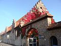
The Catholic branch church at Bamberger Straße 67 still forms the center of the village today. A church in Düllstadt did not exist for a long time, only after the destruction of the Thirty Years War did people start thinking about a church. The abbot of Münsterschwarzach promoted the resettlement of residents by building the church. It was inaugurated on September 29, 1688. In the period that followed, the church underwent several additions and renovations. At the beginning of the 19th century, the cemetery was moved from the churchyard to the outskirts. Today the church is part of the parish of Schwarzach.
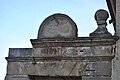
The church is a small hall with a retracted, polygonal choir . Above the choir there is a six-sided roof turret that ends with a dome. The choir was built inside with a barrel vault. The interior of the church is varied and features objects from all centuries since it was built. A stone that probably comes from the Egbert Church in Münsterschwarzach and was decorated with the inscription " Wolfgangnus Abbas Anno Domini 1557" is particularly valuable .
Former mill
The former monastery mill in Mühlweg on the outskirts of the village can be described as the oldest building in Düllstadt. It was first mentioned in a document as early as the 13th century. During the Middle Ages , the premises of the Munster Blackachian Amtshof existed , which was administered by the monks. At the beginning of the 18th century, the current building was built after a fire . After secularization in 1803, the property came into private hands and was converted into a mill .
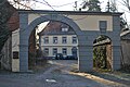
The mill presents itself as a two-storey mansard roof building with a stately exterior. The windows of the building are drilled and the corners are closed with pilasters . A cornice separates the lower and upper floors. The yard gate of the facility, which communicates to the property, has a large passage and a smaller passage. Similar to the main house, the courtyard gate was equipped with corner pilasters. In addition to the mill, a sawmill was also operated in the building.
Private houses and small monuments
Several buildings have been preserved in Düllstadt, which are evidence of past centuries. Magnificent courtyard gates in particular are typical of Düllstadt. The door of the former Lohmühle at St.-Michael-Straße 10 is marked with the year 1732. The mill produced Lohe for the tanneries and the owners rose to some wealth, so that they could equip their workplaces with a drilled portal with a skylight . The same property also houses an Immaculata figure, which was placed in the base with the year 1779.

The former sheep farm in Mühlweg 1 is historically significant. It was built around 1732 as a single-storey saddle roof building with a stepped gable . Similar to the much larger manor, its quarry stones remained unplastered. A courtyard gate with a semicircular attachment, which is marked 1732, is built in front of the property. The farmhouse at Bamberger Straße 58, on the other hand, is younger. It dates back to the last decades of the 18th century with its mansard gable roof. The house is one-story and was inhabited by the Weckert family for a long time. Today the Dorsch family lives in the property.
An old Franconian four-sided courtyard has been preserved at Klosterweg 2. The two-storey house from the 18th century has partially drilled window frames. The barns and outbuildings are much simpler. The courtyard gate, which was built in 1778, is characteristic of the house. A figure of St. John Nepomuk sits enthroned above the passage, framed by two vase attachments . The figure of the bridge saint may have come here from the nearby Castellbach Bridge.
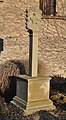
The youngest monument in Düllstadt is the former manor located at Bamberger Straße 50. It was built on this site in the 1920s and 1930s and was built with stepped gables, similar to the town hall and the Schwarzach sheep farm. The elongated courtyard is grouped around an inner courtyard. Only a wayside shrine is still listed today in Düllstadt. It is the so-called Stifter-Marterl from 1680. The essay represents a Pietà , on the back the eponymous donors have immortalized themselves.
Monastery mill on the outskirts of the village

Door frame of the former Lohmühle

Former sheep farm in Mühlweg
Portal of the sheep farm

Farmhouse at Bamberger Strasse 58
Former manor
Wayside shrine with Pietà


Wasenmeisterei
The courtyards of a former Wasenmeisterei are located in the north of the Düllstadt district and were an independent district of Reupelsdorf until the 1970s. Since the Middle Ages, there have been individual farms away from the villages, which were inhabited by the so-called washer masters or knackers . They were obliged by the authorities to collect, remove and recycle the animal carcasses in their district. The unpleasant smell and the risk of illness led to the Wasenmeister being counted among the dishonest professions.
Between Reupelsdorf and Düllstadt, such a washer-maintenance shop was established in the 18th century, and in 1799 the wasen-master Johann Jörg Beck was mentioned for the first time, who can also be named as the builder of the buildings. Michael Sedelmayer ran the master workshop in 1820; before 1869 he was replaced by Johann Beck. Subsequently, the Ungemach family, Georg Philipp Ungemach, came to the facility, which is still owned by the former Wasenmeisterei. In the course of the municipal reform , the farm came into the district of Düllstadt.
"Castle" Düllstadt
The so-called castle on the outskirts of the village has been preserved at Bamberger Straße 60. It is not classified as a monument and has never served as a mansion. The name of the castle (or, more commonly, Schlössla) was only given to the building from its construction by a nobleman. In 1888, Baron Leopold von Klippstein had the property built as a residence for his family. Then the siblings Maria and Christian Jordan from Repperndorf owned the castle.
After the death of her brother, Maria Jordan bequeathed the building to her son from her first marriage, Otto Wilhelm Rauhenzahner. Rauhenzahner described himself as a manor owner and further adorned the history of his house. The Counts of Schönborn are said to have built the castle in Düllstadt. Rauhenzahner later got into debt and had to auction the property in 1930. It was acquired by Jakob Bühler, the director of Südzucker AG, for 140,000 Reichsmarks .
During the Second World War the castle stood empty and fell into disrepair. A hospital was temporarily housed here, and refugees also moved into the property. In 1970 the Spies family acquired the castle, which was surrounded by a large park . They set up an inn on the premises . In 1975 apartments were set up in the property. In the period that followed, usage changed more frequently. In 1997 the manor that originally belonged to the castle was sold separately. Today there is a youth facility in the premises.
The castle has a simple rectangular floor plan and ends with a flat hipped roof . It has two storeys, the entrance is marked by a risalit with accented gable. The sandstone facade is only structured by a few cornices . Four window axes were attached to the narrow sides, while the long side is illuminated by a total of seven window axes. In the 20th century, a winter garden was built on the back in the form of a baroque style. The original park has almost disappeared, the building fabric has largely been left to decay.
Regular events
Several regular events shape the course of the year in Düllstadt. The so-called field jury drink can be described as the oldest of such events, although it is not fixed on a date. At the inauguration of a new seven in Düllstadt, a party with a drink is held. The field jury or sevens still cross half of the district once a year to check the setting of the boundary stones .
Younger, on the other hand, is the tradition of setting up the maypole on May 1st, when a birch tree is set up in front of Michaelskirche. Typically Franconian is the custom that the village youth walk through the village with so-called lyres during the quiet Whitsun period and ask for small gifts. In addition, the patron saint of the Church of St. Michael is celebrated on September 29th . In addition, the so-called Sand Hare Festival has existed since 1976, which self-ironically picks up on the Ortsneck name of Düllstadt.
Economy and Infrastructure
economy
Economically today, Düllstadt has largely merged into the structures of the community of Schwarzach am Main. Similar to the neighboring towns, people commute to the large industrial companies in Kitzingen or Würzburg. Agriculture and livestock farming, which shaped the place for centuries, no longer play a major role. In 2018 there were still two full-time farmers, and part-time farms were built in the buildings of the old town, which are still designed for agriculture. The Hartmann nursery , with its greenhouses along Atzhäuser Strasse, is the most striking company in the village. It cultivates 12 hectares .
In 1922 an entrepreneur tried to set up a ketchup factory in Düllstadt , but the attempt failed. Due to the traffic connection of the federal road 22 and the proximity to the federal freeway 3 , several service companies emerged on site in the first decades of the 21st century . There is an outpatient care service, a tire shop and an engineering office for agricultural field tests in Düllstadt.
Infrastructure
Düllstadt is crossed by the federal road 22 , the predecessor of which mediated between Würzburg- Schwarzenau- Bamberg in the Middle Ages and early modern times . In the village, the main road is called Bamberger Straße, which refers to the destination of the route. The road crosses the Castellbach in the local area. A regional bike path runs parallel to the main road from Stadtschwarzach through the village. State road 2421 is also significant , which joins the federal road in Düllstadt and is called Atzhäuser Straße in the village.
| List of teachers (selection) | |||||||
|---|---|---|---|---|---|---|---|
| Surname | Term of office | ||||||
| N. Matei | - after 1924 | ||||||
| Franz Volk | 1927-1963 | ||||||
| Joseph Michel | 1963-1965 | ||||||
Today there is no longer a school in Düllstadt. The place is part of the primary school district Schwarzacher Becken, the school was closed in 1965. The still existing school building next to the town hall and the church was built between 1823 and 1825. In the 1860s, the school received a large school garden, which even included a tree nursery . In 1910 the school building was expanded to include a classroom. Most recently there was a one-class school in Düllstadt.
Düllstadt is located in the district of the Dettelbach-Volkach secondary school network and is assigned to the Rudolf-von-Scherenberg secondary school in Dettelbach. Secondary schools can be attended with the girls' secondary school in Volkach and the secondary school in Dettelbach. There are high schools in Münsterschwarzach ( Egbert-Gymnasium ), Volkach-Gaibach ( Franken-Landschulheim Schloss Gaibach ), Wiesentheid ( Steigerwald-Landschulheim ) and Kitzingen ( Armin-Knab-Gymnasium ).
Despite the small size of the village, there are several associations in Düllstadt that shape everyday life in the village. The oldest of these associations is the volunteer fire brigade , which was founded in 1874 and is therefore the oldest of such brigades in the Schwarzach Basin. The fire brigade was not officially recognized until March 11, 1875. In 2017, the Düllstadt fire brigade was merged with that of Hörblach as a fire fighting group due to a lack of personnel . The fire station is near the church.
The Sand Hare Association founded in 1981 is important for the cultural identity of the people of Düllstadt. Among other things, he campaigns for the beautification of the village, promotes the maintenance of the landscape and organizes festivities in the village. He also takes care of the preservation of the wayside shrines and small monuments. In addition, the hunting lease plays a historical role for the place with its former estate. A senior Stammtisch was organized for senior citizens.
literature
Literature about Düllstadt
- Franziskus Büll, Josef Gerlach: Schwarzach am Main in old views . Zaltbommel NL 1991.
- Alexander Graf zu Castell: Düllstadt . In: Jesko Graf zu Dohna (ed.): Kulturpfad. In the footsteps of the Counts of Castell . Münsterschwarzach 2004. p. 89.
- Hans A. Dresch: Sources and reports on the history of the market town of Schwarzach am Main. Part 1 . Schwarzach am Main 1986.
- Adelhard Kaspar: A remnant of the medieval church Münsterschwarzachs . In: The Mainland. History and present. 6th century No. 20 . Würzburg 1955. p. 104.
- Günter Wich: 1100 years of Düllstadt. 918-2018. A picture book with texts . Münsterschwarzach 2018.
Other literature used
- Hans Bauer: District of Kitzingen. An art and culture guide . Market wide 1993.
- Monika Fritz-Scheuplein, Almut König, Sabine Krämer-Neubert, Norbert Richard Wolf: Dreidörfer fools stand on three rafters. Ortnecknames in Lower Franconia . Würzburg 2012.
- Erwin Probst: Vogt and Lord of the village and field. Contributions to the history of legal life in the former monastery Blackachian bailiwick villages . In: Studia Suarzacensia. Contributions to the history of the Münsterschwarzach Abbey on the occasion of the 50th anniversary of its resettlement (= Würzburg diocesan history sheets 25th vol.) . Münsterschwarzach 1963. pp. 145–168.
- Walter Schilling: The castles, palaces and mansions of Lower Franconia . Würzburg 2012.
- Karl Treutwein : From Abtswind to Zeilitzheim. History, sights, traditions . Volkach 4 1987.
- Gabriel Vogt: Market Schwarzach am Main . In: District Administrator and District Council of the District of Kitzingen (Hrsg.): District of Kitzingen . Münsterschwarzach 1984. pp. 494-504.
Web links
Individual evidence
- ^ Wich, Günter: 1100 years of Düllstadt . P. 9.
- ^ Wich, Günter: 1100 years of Düllstadt . P. 9.
- ^ Wich, Günter: 1100 years of Düllstadt . P. 14.
- ^ Büll, Franziskus: Das Monasterium Suuarzaha . P. 17.
- ↑ See: Bauer, Hans: District of Kitzingen . P. 38.
- ^ Vogt, Gabriel: Market Schwarzach am Main . P. 503.
- ^ Büll, Franziskus: Das Monasterium Suuarzaha . P. 42.
- ^ Castell, Alexander Fürst zu: Düllstadt . P. 89.
- ^ Probst, Erwin: Vogt and Lord to village and field . P. 147 and 153.
- ^ Dresch, Hans A .: Sources and reports on the history of the market town of Schwarzach am Main. Part 1 . P. 67.
- ^ Dresch, Hans A .: Sources and reports on the history of the market town of Schwarzach am Main. Part 1 . P. 75.
- ^ Bauer, Hans: District of Kitzingen . P. 38.
- ^ Wich, Günter: 1100 years of Düllstadt . P. 92 f.
- ^ Büll, Franziskus (among others): Schwarzach am Main in old views . Fig. 68.
- ^ Treutwein, Karl: From Abtswind to Zeilitzheim . P. 60.
- ^ Treutwein, Karl: From Abtswind to Zeilitzheim . P. 60.
- ^ Wich, Günter: 1100 years of Düllstadt . P. 7.
- ^ Fritz-Scheuplein, Monika (among others): Ortsnecknames in Lower Franconia . P. 50 and 39.
- ^ Wich, Günter: 1100 years of Düllstadt . P. 63.
- ^ Wich, Günter: 1100 years of Düllstadt . P. 64.
- ↑ Main-Post: Congratulations, Max Schwanfelder , accessed on December 26, 2019.
- ^ Wich, Günter: 1100 years of Düllstadt . P. 65.
- ↑ Bavarian State Statistical Office (ed.): Official city directory for Bavaria, territorial status on October 1, 1964 with statistical information from the 1961 census . Issue 260 of the articles on Bavaria's statistics. Munich 1964, DNB 453660959 , Section II, Sp. 866 ( digitized version ).
- ^ Wich, Günter: 1100 years of Düllstadt . P. 9.
- ^ Bavarian State Statistical Office (ed.): Official place directory for Bavaria . Issue 335 of the articles on Bavaria's statistics. Munich 1973, DNB 740801384 , p. 188 ( digitized version ).
- ↑ Bavarian State Office for Statistics and Data Processing (Ed.): Official local directory for Bavaria, territorial status: May 25, 1987 . Issue 450 of the articles on Bavaria's statistics. Munich November 1991, DNB 94240937X , p. 366 ( digitized version ).
- ↑ Bavarian State Statistical Office (Hrsg.): Historical municipality register: The population of the municipalities of Bavaria in the period from 1840 to 1952 (= contributions to Statistics Bavaria . Issue 192). Munich 1954, DNB 451478568 , p. 198 , urn : nbn: de: bvb: 12-bsb00066439-3 ( digital copy ).
- ^ Wich, Günter: 1100 years of Düllstadt . P. 9.
- ^ Wich, Günter: 1100 years of Düllstadt . P. 79.
- ↑ Kaspar, Adelhard: A remnant of the medieval church Münsterschwarzachs . P. 104.
- ^ Wich, Günter: 1100 years of Düllstadt . P. 92.
- ↑ Schilling, Walter: The castles, palaces and mansions of Lower Franconia . P. 260.
- ^ Wich, Günter: 1100 years of Düllstadt . P. 115.
- ^ Wich, Günter: 1100 years of Düllstadt . P. 128.
- ^ Wich, Günter: 1100 years of Düllstadt . P. 35.
- ^ Wich, Günter: 1100 years of Düllstadt . P. 110 f.
