
Gerolzhofen district
| coat of arms | Germany map | |
|---|---|---|

|
Coordinates: 49 ° 54 ' N , 10 ° 21' E |
|
| Basic data (as of 1972) | ||
| Existing period: | 1862-1972 | |
| State : | Bavaria | |
| Administrative region : | Lower Franconia | |
| Administrative headquarters : | Gerolzhofen | |
| Area : | 477.42 km 2 | |
| Residents: | 41,200 (Dec 31, 1971) | |
| Population density : | 86 inhabitants per km 2 | |
| License plate : | GEO | |
| Circle key : | 09 6 38 | |
| Circle structure: | 77 parishes | |
| Address of the district administration: |
8723 Gerolzhofen | |
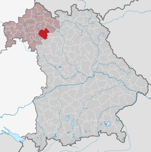
| Location of the Gerolzhofen district in Bavaria | ||
  |
||

The district of Gerolzhofen in the Bavarian administrative district of Lower Franconia was dissolved in 1972 as part of the regional reform in Bavaria .
geography
Neighboring areas
Starting in 1972, the district bordered clockwise in the northwest on the districts of Schweinfurt , Haßfurt , Bamberg , Scheinfeld and Kitzingen .
history
The Gerolzhofen District Office was formed in 1862 through the merger of the Gerolzhofen and Wiesentheid regional courts . This was enlarged in 1872 by some communities from the disbanded Volkach district office .
On the occasion of the reform of the layout of the Bavarian district offices, the Gerolzhofen district office ceded the Wiesenbronn community to the Kitzingen district office on January 1, 1880 .
On January 1, 1939, the designation district was introduced as everywhere else in the German Reich . This is how the district office became the district of Gerolzhofen.
Due to the district reform , the district was dissolved on July 1, 1972:
- The communities Geusfeld , Wohnau and Wustviel came to the district of Haßberge , which until May 1st, 1973 was called Haßberg-Kreis .
- The cities of Prichsenstadt and Volkach as well as the municipalities of Abtswind , Altenschönbach , Astheim , Atzhausen , Bimbach , Brünnau , Castell , Dimbach , Düllstadt , Ebersbrunn , Eichfeld , Escherndorf , Fahr , Feuerbach , Gaibach , Geesdorf , Greuth , Järkendorf , Kirchschönbach , Köhler , Krautheim , Laub , Neudorf , Neuses am Sand , Nordheim am Main , Obervolkach , Rehweiler , Reupelsdorf , Rimbach , Rüdenhausen , Sommerach , Stadelschwarzach , Untersambach , Wiesentheid and Wüstenfelden came to the Kitzingen district .
- The communities Obereisenheim and Untereisenheim came to the district of Würzburg .
- All other communities including the district town of Gerolzhofen came to the district of Schweinfurt .
The former district town of Gerolzhofen initially retained a number of supra-local authorities, but all of them, with the exception of a police station, were subsequently closed.
Population development
| year | Residents | source |
|---|---|---|
| 1864 | 20,868 | |
| 1885 | 32,179 | |
| 1900 | 30,470 | |
| 1910 | 31,502 | |
| 1925 | 32,132 | |
| 1939 | 32,048 | |
| 1950 | 44,336 | |
| 1960 | 39,000 | |
| 1971 | 41,200 |
Communities
The municipalities of the Gerolzhofen district and their current affiliation:
traffic
The area of the former district of Gerolzhofen is affected by the federal highway 3 , the federal highways 286 and 22 , the railway line Kitzingen-Schweinfurt , the Mainschleifenbahn and the federal waterway Main .
License Plate
On July 1, 1956, the district was assigned the GEO distinctive sign when the vehicle registration number that is still valid today was introduced . It was issued until April 28, 1973. It has been available again in the Schweinfurt district since July 10, 2013 as part of the license plate liberalization , and in the Haßberge district since April 1, 2014.
Individual evidence
- ^ Wilhelm Volkert (ed.): Handbook of Bavarian offices, communities and courts 1799–1980 . CH Beck, Munich 1983, ISBN 3-406-09669-7 , p. 471 .
- ^ Wilhelm Volkert (ed.): Handbook of Bavarian offices, communities and courts 1799–1980 . CH Beck, Munich 1983, ISBN 3-406-09669-7 , p. 97 .
- ^ Federal Statistical Office (ed.): Historical municipality directory for the Federal Republic of Germany. Name, border and key number changes in municipalities, counties and administrative districts from May 27, 1970 to December 31, 1982 . W. Kohlhammer, Stuttgart / Mainz 1983, ISBN 3-17-003263-1 , p. 743 f. and 758 .
- ^ Ordinance on the reorganization of Bavaria into rural districts and independent cities of December 27, 1971
- ^ Eugen Hartmann: Statistics of the Kingdom of Bavaria . Ed .: Royal Bavarian Statistical Bureau. Munich 1866, population of the district offices 1864, p. 106 ( digitized version ).
- ↑ Royal Bavarian Statistical Bureau (ed.): Localities directory of the Kingdom of Bavaria . Munich 1888, population figures of the district offices 1885 ( digitized ).
- ↑ a b www.gemeindeververzeichnis.de: Lower Franconia
- ↑ for the Free State of Bavaria, according to the census of June 16, 1925
- ↑ Statistical Yearbook for the German Reich 1940
- ↑ Statistical Yearbook for the Federal Republic of Germany 1952
- ↑ Statistical Yearbook for the Federal Republic of Germany 1961
- ↑ Statistical Yearbook for the Federal Republic of Germany 1973
- ^ Michael Rademacher: German administrative history from the unification of the empire in 1871 to the reunification in 1990. Ebern district. (Online material for the dissertation, Osnabrück 2006).
- ↑ BayernViewer of the Bavarian Surveying Administration (accessed on June 27, 2010)
Aichach | Alzenau i.UFr. | Amberg | Bad Aibling | Bad Neustadt adSaale | Bad Toelz | Beilngries | Berchtesgaden | Bow | Brückenau | Burglengenfeld | Dingolfing | Dinkelsbühl | Donauwörth | Ebermannstadt | Boars | Eggenfelden | Erlangen | Eschenbach idOPf. | Feuchtwangen | Friedberg | Feet | Gemünden a.Main | Gerolzhofen | Grafenau | Griesbach i.Rottal | Gunzenhausen | Hammelburg | Hassfurt | Hersbruck | Hilpoltstein | Höchstadt adAisch | Hofheim i.UFr. | Illertissen | Ingolstadt | Karlstadt | Kaufbeuren | Kemnath | Kempten (Allgäu) | Königshofen i.Grabfeld | Kötzting | Krumbach (Swabia) | Landau adIsar | Lauf adPegnitz | Running | Lohr a.Main | Mainburg | Mallersdorf | Marktheidenfeld | Marktoberdorf | Mellrichstadt | Memmingen | Mindelheim | Münchberg | Nabburg | Naila | Neuburg adDonau | Neunburg vorm Wald | Neustadt adAisch | Nordlingen | Nuremberg | Obernburg am Main | Oberviechtach | Ochsenfurt | Parsberg | Pegnitz | Parish churches | Rehau | Riedenburg | Roding | Rothenburg ob der Tauber | Rottenburg adLaaber | Scheinfeld | Schongau | Schrobenhausen | Schwabach | Schwabmünchen | Sonthofen | Stadtsteinach | Staffelstein | Straubing | Sulzbach-Rosenberg | Uffenheim | Viechtach | Vilsbiburg | Vilshofen | Vohenstrauss | Waldmünchen | Wasserburg a.Inn | Wegscheid | Weilheim i.OB | Weißenburg i.Bay. | Wertingen | Wolfratshausen | Wolfstein
1939–1945 affiliated districts: Bergreichenstein | Eisenstein market | Prachatitz