
Koehler (Volkach)
|
Charcoal burner
City of Volkach
|
|
|---|---|
 |
|
| Height : | 220 m |
| Area : | 73 ha |
| Residents : | 73 (1987) |
| Population density : | 100 inhabitants / km² |
| Incorporation : | July 1, 1972 |
| Postal code : | 97332 |
| Area code : | 09381 |
 Location of Köhler (bold) within the Volkach municipal area
|
|
 |
|
Köhler is a district of the town of Volkach in the Bavarian district of Kitzingen in Lower Franconia . Köhler was an independent municipality until the voluntary merger with Volkach on July 1, 1972. Historically, the village was part of the Würzburg monastery for a long time and had been connected to the nearby city via the Volkach monastery since the 17th century.
Köhler is the smallest Volkach district with its own boundary. A large part of this is taken up by vineyards that have been feeding the people of Köhler for centuries. In addition to viticulture, the village lives from tourism , and the location on the edge of the Volkacher Mainschleife also contributes to this.
Geographical location
Geography and natural location
Köhler is located in the extreme south-west of the Volkach municipality. In the north, about 2 kilometers away, is Escherndorf , which is also a district of Volkach. Further east, on the other side of the Main, the so-called Wine Island begins . The district of Nordheim am Main with the Kreuzberg is closest to Köhler. The Dettelbach area borders the village in the south and south-west . In the south is the district of Neuses am Berg , to the southwest lies Neusetz . The south-east is taken by Prosselsheim in the district of Würzburg.
The closest larger cities are Kitzingen , which is about 12 kilometers away, and Schweinfurt , which is about 22 kilometers away. The next big city is Würzburg, 18 kilometers away .
Naturally, Köhler is in the area of the Volkacher Mainschleife, which is counted as a sub-unit of the Middle Main Valley of the Mainfränkische Platten .
The village is located in the Maingau climate zone, which is one of the driest and warmest climate zones in Germany. This also explains the local viticulture. Köhler can be found in the extreme southwest of the Volkacher Mainschleife. Here the wide land area, which was created as a Kerbtal near Escherndorf, merges into the rebound slope , so that there was little space left for settlement. The slope is characterized by rocks of the shell limestone , which are interspersed with Lettenkeuper and clay marl . The houses stand on Main gravel and sand.
Village structure
The district of Köhler covers an area of 0.73 km² and is thus the smallest Volkach district with its own district. The small, single-row hackers - street village is centrally located and runs along the Maine way, why was popularly because only one row houses of the saying: " In Koehler are the pancakes on one side only baked ". The special type of settlement arose from the special location between the river and the mountain. The branch church of St. Andreas forms the center of the populated area and is framed by a total of 31 houses.
South of the church on the banks of the Main is the Mainaue nature reserve between Sommerach and Köhler. The protection area is intended to protect the last remains of the Aue biotope , which has been preserved on the so-called Altmain. The village is dominated by the approximately 240 m high Fürstenberg. Above this height the landscape flattens out. In the extreme southern end of the district there is an unnamed lake.
history
Prehistory and early history (until 1253)
Unlike many other communities on the Mainschleife, Köhler does not have a long history of settlement. No archaeological finds were made here. However, there was already a settlement on the nearby Vogelsberg in the Paleolithic . In the Bronze Age , around 1500 BC BC, the inhabitants built fortifications on the mountain, which were further strengthened in later centuries. For a long time, the mountain was also a cult focal point for the surrounding area.
For the neighboring Escherndorf, the first archaeological finds from around 50 BC can be proven. Celts who were sitting on the Vogelsburg at that time were buried immediately north of Köhler . They were later ousted by the Thuringians . Finally, the Franks reached the area around the Main Loop and established real administrative structures for the first time. This is how two royal courts were created in Prosselsheim and on the Vogelsburg. However, the Koehler area remained uninhabited.
Along with Christianity , viticulture also came to the region with the Franks . For the first time it can be found in the 7th or 8th century on the slopes around the Vogelsburg. However, it was only the advancing viticulture technology that made it possible to cultivate even the steepest slopes. Today's contiguous wine-growing area around Escherndorf-Köhler was created after 1127. During this time, Köhler established itself as a storage place for wine; there was a good place here to land the cargo on the Main .
The Würzburg Monastery (until 1803)
The first mention of wine landing site for the first time in 1253. At that time received Albertus de Ostheim, a resident of the nearby Astheims , "septum jugera vineta sita in cellar" (lat. Seven vineyards, located in Kohler) from the Cistercian monastery Ebrach to fief . In 1293 the village was named again. Again, the Ebrach monastery lent two acres of vineyards "in monte keller" (lat. Am Berg Keller) to Gozwin Strüber.
Although the Ebrach monastery had some possessions in Köhler, the Würzburg monastery can be regarded as the actual village lord. In 1303 Heinrich von Eisenheim , the courtiers from Prosselsheim, Hermann Zink and Engelhard Jungherr von Frickenhausen were given fiefs from the bishopric "am Keller et in Vogelspurk". In 1340, however, some residents were still Ebrach subjects and assigned to the Elgersheim office. In the 14th century, the Münsterschwarzach monastery also held some vineyards in the village.
The remainder of the Middle Ages in Koehler is characterized by a great lack of sources. In 1495, only one Steffan Stahel von Köhler is mentioned in the book of the Sebastian Brotherhood from Volkach. In 1575 Köhler was finally part of the high pin and the centering assigned Prosselsheim. The village sent two lay judges to Prosselsheim for the blood court . In particular, the regulation of criminal offenses has now been regulated for the first time. As in Escherndorf, grape theft was not a trivial offense in Koehler and was severely punished.
Köhler already owned a small church in the 16th century. It was first mentioned in 1576. The parish was part of the parish Prosselsheim. At the same time, Lutheran ideas reached the small wine-growing village and the population was split into two camps. Only with the establishment of a Catholic parish in nearby Escherndorf, whose branch became Köhler in 1604, the village could be re-Catholicized again. The Würzburg prince-bishop Julius Echter von Mespelbrunn pushed the Counter-Reformation forward.
During the Thirty Years' War Köhler also suffered from frequent passages by foreign powers. First of all, the war made itself felt by a labor shortage, as the village was dependent on many foreign workers during the wine season. The plague later broke out in the town. In addition, so-called contribution demands of the warring powers burdened the population. In the absence of livestock, this was mostly paid for in cash.
After the war the village was completely impoverished. The so-called Little Ice Age also caused the vineyard harvests to decline sharply. In 1662 the Würzburg prince-bishop still ruled over Köhler. The population of the Würzburg Carmelite Monastery and the Püssensheim parish delivered the vineyard tithes . Three houses in the village were assigned to the Margraves of Brandenburg-Ansbach. In 1698 the village came to the Hochstiftisches Amt Volkach.
In Bavaria (until today)
In the course of Napoleon's conquests in Central Europe, the Würzburg bishopric was dissolved by the Reichsdeputationshauptschluss in 1803. Köhler came to Kurpfalzbayern until 1805. Then after the Peace of Pressburg, Archduke Ferdinand of Tuscany established the Grand Duchy of Würzburg by Napoleon's grace. Köhler was part of this structure. It was not until June 19, 1814 that the Würzburg area became part of Bavaria, which had now become a kingdom , and Köhler became a rural community .

In the village itself, the villagers were responsible for the viticulture themselves for the first time and were allowed to cultivate their mountains independently as citizens . This was initially associated with some problems because the residents also opened up unsuitable locations . Köhler suffered particularly from bad wine years. In 1845 there was even an article that claimed "in all of Lower Franconia there is no community as poor (...) as that of Köhler".
The Volkach Regional Court tried to master the poor economic situation, which also affected other communities, by promoting fruit growing on the Mainschleife. The relief around Koehler put a stop to these efforts. In the 19th century, the Koehler population therefore often had to work as day laborers for Escherndorf winemakers, whose good vineyards were not affected by the decline. The emergence of phylloxera aggravated the situation around 1880.
In the 20th century, Köhler was also affected by the two world wars. Five men from the village died in the First World War . Five villagers also lost their lives in World War II . In the last days of World War II, an American infantry regiment advanced from Prosselsheim to nearby Escherndorf. A few days later the regiment moved on to Nordheim. Koehler himself was not directly affected by the fighting.
The idea of opening up the Mainschleife for large ships had already been discussed at the beginning of the 20th century . For this purpose, a 315 m long shipping tunnel was to be dug through the Vogelsberg. The idea was initially rejected. However, in 1941 the planners submitted another plan to bypass the narrow loop of the river. This time a 1540 m long tunnel between Fahr and Köhler was planned. A lock was to be built in Koehler . Again, the plan was not implemented.
Finally, the Volkach-Gerlachshausen Main Canal was built between 1950 and 1957 . Koehler was now shut off from shipping, but culture and excursion tourism was able to establish itself on the so-called "Altmain" . From the summer of 1961, land consolidation was also promoted in the village and the outdated vineyards made profitable again. In 1970 the village suffered from a major flood . In 1972 Köhler was incorporated into the city of Volkach. In 2011 the Main rose again over its banks.
Place name
The name of the place refers to the natural occurrences in the area. This is how the village emerged on a narrow, shady ravine , which was called the cellar after its appearance. Here the erosion channel ran to Neusetz. For a long time the name was derived from the many cellars that were needed to store wine. However, there are only a few of these cellars in Köhler because they would fill up with floods. The more recent research assumes a Wendish - Slavic origin of the place name.
Unlike many other places in the area, Köhler was probably only established as a so-called expansion site in the late Middle Ages . The place name was subject to frequent changes in the period that followed. In 1253, the term “keller” was still used. In 1293, only the mountain above was given the name “monte keller” (Latin: Berg Keller). In 1495 the name "Kelle" appeared, while in 1662 the village was called "Köller". In the same year, the "Koller" corridor also appeared .
Administration and courts
|
The following administrative units were superordinate to the municipality of Köhler.
|
In court, Köhler was subject to the following instances.
|
coat of arms
|
|
Blazon : “Divided by blue and black; at the top a golden semicircle, inside a red bar framed by five, two to three set, red balls; an inverted silver stepped gable below. " |
| Reasons for the coat of arms: The coat of arms refers, historically incorrect, to the name of the village. The red balls and the bar are an indication of the activities of the charcoal burner , who converts wood into charcoal and thereby promotes deforestation . The stepped gable, on the other hand, should refer to the erosion channel in which the village is located. |
politics
From mayor to local spokesman
For a long time Köhler was an independent municipality with its own administration. However, the structures of this administration in the Middle Ages and early modern times have not been handed down. However, it was customary in the surrounding villages at that time for a mayor representing the rulership, here of the Duchy of Würzburg, to live in the village. In addition, the population chose a citizen or village master, who represented the village to the authorities , but had no powers.
The small village became an independent parish at the beginning of the 19th century. The residents were allowed to elect a mayor and appoint a local council. In the course of the municipal reform in Bavaria in the 1970s, however, the small municipalities had to join larger towns. In Köhler it was planned to become part of the nearby town of Volkach. After some negotiations, Köhler became part of the city on July 1, 1972 and lost its centuries of independence.
The last mayor, Ambros Selsam (1899–1990) and his deputy, Johann Pfister, were able to achieve, before the dissolution, that the thoroughfare should be expanded, Köhler had its own sewer system and that the population was connected to the sewage treatment plant. In 1969 Selsam had already received honorary citizenship of the community. His deputy became the first local spokesman for Köhler in the Volkach city council . Michael Sauer has held this post since 1998.
Population development
The population of Köhler consisted of about 90 individuals in the period after the Thirty Years War. During the first half of the 19th century the population increased and reached its peak in 1811 with 136 people. In the second half of the century the number fell again and in the first half of the 20th century it still fluctuated around 100 people. Only after the Second World War did the town begin to shrink .
| year | Residents | year | Residents | year | Residents |
|---|---|---|---|---|---|
| 1662 | approx. 90 | 1875 | 104 | 1950 | 108 |
| 1811 | 136 | 1888 | 105 | 1961 | 80 |
| 1832 | 123 | 1900 | 96 | 1970 | 87 |
| 1867 | 101 | 1925 | 105 | 1987 | 73 |
Culture and sights
Architectural monuments

Andreas Church
The center of the village is the Roman Catholic branch church of St. Andreas. A church in Köhler was mentioned for the first time in 1576. The community initially belonged to the Prosselsheim parish before it was assigned to the Escherndorf parish in the 17th century. The church in its present form was not built until the first half of the 18th century. The church was last renovated in 2015.
The church ends with a small roof turret. The choir is built rectangular. The interior is very valuable, atypical for such a small village church. From the old church, only the sacrament house could be preserved, but two figures from the Riemenschneiderschule came here later . The Andreaskirche received many other pieces of equipment after the dissolution of the monastery on the Vogelsburg.
Private houses and small monuments
Due to its size, only very few architectural monuments have survived in Köhler . To the south of the church is a large house from the 18th century. It presents itself as a two-storey half-timbered building on a hook-shaped floor plan. A stone relief showing the crucifixion of Christ and dating from 1784 was attached to the building. A wayside shrine in the form of a Pietà can also be found on a vineyard path above the village . It was erected here in 1722.
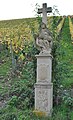
On the other hand, the so-called monolith shrine on the road to Escherndorf has been preserved from the time of the Counter Reformation. It was set up by the Würzburg prince-bishops as part of a kind of campaign against the spreading Lutheranism in the area of the Main Triangle . The Köhler Stock was created in 1605 at the time of Prince Bishop Julius Echter von Mespelbrunn and was created by the so-called Master MO .
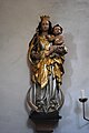
The Crescent Madonna in the Church

The half-timbered house in town

The stone relief from 1784

The wayside shrine from 1605
The Pietà on the Weinbergsweg


Regular events
The parish of Köhler has been organizing a pilgrimage to the Maria im Sand church in Dettelbach since the 19th century . The procession was first mentioned in 1897. Originally they ran on the Sunday before Bartholomew's Day , August 24th. Today the pilgrimage is held together with Escherndorf on the first Sunday in May. The pilgrims walk via Neuses am Berg to Dettelbach. The pilgrimage picture was created in 1997 by Martin Friedrich and shows the Johanneskirche in Escherndorf .
The church also shapes the rest of the year in Köhler. This is how the custom arose of sending the children of the village from house to house with ratchets during the Karzeit . The loud instruments are supposed to symbolize the lack of bell sound during this time. The custom was temporarily dormant and has only recently been revived. Although wine is grown in the village, Koehler does not hold its own wine festival .
Economy and Infrastructure
economy

The economy of the village is still strongly influenced by viticulture. Already in the Middle Ages the inhabitants lived mainly from viticulture, because other products could not be grown at all due to the relief . Although the Köhler winegrowers planted their vines on the same slope as the Escherndorfers and used the same corridors, wine never brought great wealth to the place. The Langenberg or Fürstenberg, which is cultivated on, faces east and the vines do not receive the same amount of sunlight .
Originally there were two separate vineyards in Köhler. The winemakers marketed their wine under the names "Langenberg" and "Engelsgepräng". In the course of the land consolidation in the 1960s, however, the locations were combined and standardized. Köhler lost its own site name in 1972 and has since been marketing the wine under the name "Fürstenberg". Several wineries are located in the village.
Cultural and excursion tourism now plays a further role in the economic life of the village. Next to the church, a restaurant with a beer garden on the Main forms the center of the village. The connection to the river is also represented by raft trips that can be booked in town. Köhler probably owned a schelch ferry himself in the 19th century . Today the residents use the Main ferry Nordheim am Main .
| Vineyard | Size 1830 | Size 1899 | Size 1940 | Size 1976 | Compass direction | Slope | Main grape varieties | Great location |
|---|---|---|---|---|---|---|---|---|
| Koehler Fürstenberg | 26 ha | 22.4 ha | 19 ha | 23 hectares | East, southeast | 30-50% | Müller-Thurgau , Silvaner | Volkacher Kirchberg |
Infrastructure

Due to the relief in the area around the village, Köhler can only be reached from a district road. The district road KT 31 runs through the village coming from Escherndorf towards the south. There are no street names , because the houses are only lined up on one side of the street along the Main. Accordingly, Köhler is only the final stop of a single VGN bus line that reaches the village from Volkach via Escherndorf.
In the past, an independent educational institution was only able to establish itself briefly in the small village. From 1930 the students were taught in nearby Escherndorf. Today the elementary education is provided by the Volkach elementary school. Elementary and middle schools in nearby Volkach were combined under this name . Schoolchildren can obtain the qualifying secondary school leaving certificate and, via the so-called M-branch , the secondary school leaving certificate. Adult education is provided by the Volkach Adult Education Center.
The higher education also takes place in Volkach with the girls' secondary school . In the Volkach district of Gaibach there is the Franken-Landschulheim Schloss Gaibach, a grammar school with secondary school and boarding school. The Steigerwald-Landschulheim in Wiesentheid is also close to Köhler. In addition, the pupils can visit the private monastery high school in Münsterschwarzach.
The small size of the place is also responsible for the fact that club life was not as lively as in other places in the area. However, there is a volunteer fire brigade in Köhler that has organized itself into a fire brigade association. It is part of the Kitzingen District Fire Brigade Association and only has a portable pump trailer (TSA) for fire fighting. The current commander is Michael Sauer.
literature
Literature about Koehler
- Werner Drenkrad, Erich Schneider: Vogelsburg, Escherndorf, Koehler (= Schnell Art Guide No. 1357) . Munich, Zurich 1982.
- Gerhard Egert: The wine-growing communities Escherndorf and Köhler at the beginning of the 19th century . In: Ute Feuerbach (Ed.): Volkach. 906-2006 . Volkach 2006. pp. 306-312.
- Gerhard Egert: Escherndorf and Köhler . In: Ute Feuerbach (Ed.): Our Main Loop. 1978-1992 . Volkach 2008. pp. 124-133.
- Erwin Rutte: The main shell limestone on the Maintalhange of Köhler . Wuerzburg 1962.
- Hildegard Vollmer: Vineyard clearing in the Franconian wine-growing region Escherndorf-Köhler. Allow . Würzburg 1971.
Other literature used
- Hans Bauer: District of Kitzingen. An art and culture guide . Market wide 1993.
- Gerhard Egert: The Escherndorfer Lump . In: Ute Feuerbach (Ed.): Our Main Loop. 1993-2007 . Volkach 2008. pp. 10-16.
- Gerhard Egert: The honorary citizens of the city of Volkach . In: Ute Feuerbach (Ed.): Our Main Loop. 1993-2007 . Volkach 2008. pp. 52-58.
- Gerhard Egert: The Nordheim driving regulations from 1603 . In: Ute Feuerbach (Ed.): Our Main Loop 1993-2007 . Volkach 2008. pp. 1-4.
- Gerhard Egert: The place names as a historical settlement source. Situation structure and interpretation . In: Ute Feuerbach (Ed.): Volkach. 906-2006 . Volkach 2006. pp. 11-16.
- Gerhard Egert: The political spatial planning in the area of the Volkacher Mainschleife around 1814 . In: Ute Feuerbach (Ed.): Our Main Loop. 1978-1992 . Volkach 2008. pp. 267-270.
- Gerhard Egert: On the history of fruit growing on the Mainschleife 1700–1900 . In: Ute Feuerbach (Ed.): Our Main Loop. 1978-1992 . Volkach 2008. pp. 47-58.
- Ute Feuerbach: The wine . In: Ute Feuerbach (ed.): Volkach. 906-2006 . Volkach 2006. pp. 281-293.
- Ute Feuerbach: Court and Office Volkach . In: Ute Feuerbach (ed.): Volkach. 906-2006 . Volkach 2006. pp. 47-56.
- Ute Feuerbach, Christa Volk: Volkach and its districts . Erfurt 2011.
- Herbert Meyer: Tower button certificates in Escherndorf . In: Ute Feuerbach (Ed.): Our Main Loop. 2008-2017 . Volkach 2018. pp. 166–174.
- Franz Pfrang: The history of viticulture on the Main loop . In: Ute Feuerbach (Ed.): Our Main Loop. 1978-1992 . Volkach 2008. pp. 23-28.
- Anke Ruppert, Karl Heinrich Brückner: Pilgrimage to Dettelbach today - an inventory . In: Karl Heinrich Brückner, Peter Ruderich, Anke Ruppert, Reinhard Worschech: Maria help, it's time. From the story of the pilgrimage to “Maria im Sand” Dettelbach . Dettelbach 2005. pp. 31-167.
- Michael Steinbacher: Slavic traces along the Volkacher Mainschleife . In: Yearbook for the district of Kitzingen 2017. Under the spell of the Schwanberg . Dettelbach 2017. pp. 303–323.
- Karl Treutwein : From Abtswind to Zeilitzheim. History, sights, traditions . Volkach 4 1987.
- Hugo Walter: The breakthrough Volkach - Gerlachshausen . In: Ute Feuerbach (Ed.): Our Main Loop. 1993-2007 . Volkach 2008. pp. 231-244.
Web links
Individual evidence
- ↑ a b Bavarian State Office for Statistics and Data Processing (Ed.): Official local directory for Bavaria, territorial status: May 25, 1987 . Issue 450 of the articles on Bavaria's statistics. Munich November 1991, DNB 94240937X , p. 366 ( digitized version ).
- ↑ Main-Post: What Michael Sauer likes about Köhler , accessed on October 17, 2017.
- ↑ Geography Giersbeck: Map 152 Würzburg , PDF file, accessed on January 8, 2019.
- ^ Egert, Gerhard: Escherndorf and Koehler . P. 125.
- ↑ Feuerbach, Ute (among others): Volkach and its districts . P. 92.
- ^ Egert, Gerhard: Escherndorf and Koehler . P. 126.
- ^ Treutwein, Karl: From Abtswind to Zeilitzheim . P. 129.
- ^ Egert, Gerhard: Escherndorf and Koehler . Pp. 128-132.
- ↑ Feuerbach, Ute: Court and Office . P. 52.
- ↑ Egert, Gerhard: The political spatial planning in the area of the Volkacher Mainschleife 1814 . P. 267.
- ^ Pfrang, Franz: History of viticulture on the Main loop . P. 24.
- ↑ Egert, Gerhard: Wine-growing communities Escherndorf and Köhler in the 19th century . P. 312.
- ^ Walter, Hugo: The breakthrough Volkach-Gerlachshausen . Pp. 232, 236.
- ↑ Rutte, Erwin: The main shell limestone on the Maintalhange of Köhler . P. 181.
- ^ Bauer, Hans: District of Kitzingen . P. 23.
- ↑ infranken: Nobody goes under in Köhler , accessed on October 18, 2017.
- ^ Egert, Gerhard: The place names as a historical settlement source . P. 14.
- ↑ Steinbacher, Michael: Slavic traces along the Volkacher Mainschleife . P. 314.
- ^ Egert, Gerhard: Escherndorf and Koehler . P. 132.
- ↑ Egert, Gerhard: The honorary citizens of the city of Volkach . P. 57.
- ↑ Feuerbach, Ute (among others): Volkach and its districts . P. 91.
- ^ Egert, Gerhard: Escherndorf and Koehler . P. 132.
- ↑ Kgl. Statistical Bureau (ed.): Complete list of localities of the Kingdom of Bavaria. According to districts, administrative districts, court districts and municipalities, including parish, school and post office affiliation ... with an alphabetical general register containing the population according to the results of the census of December 1, 1875 . Adolf Ackermann, Munich 1877, 2nd section (population figures from 1871, cattle figures from 1873), Sp. 1301 , urn : nbn: de: bvb: 12-bsb00052489-4 ( digital copy ).
- ↑ Bavarian State Statistical Office (ed.): Official place directory for Bavaria - edited on the basis of the census of September 13, 1950 . Issue 169 of the articles on Bavaria's statistics. Munich 1952, DNB 453660975 , Section II, Sp. 1185 ( digitized version ).
- ↑ Egert, Gerhard: The wine-growing communities Escherndorf and Köhler in the 19th century . P. 312.
- ↑ K. Bayer. Statistical Bureau (Ed.): Localities directory of the Kingdom of Bavaria. According to government districts, administrative districts, ... then with an alphabetical register of locations, including the property and the responsible administrative district for each location. LIV. Issue of the contributions to the statistics of the Kingdom of Bavaria. Munich 1888, Section III, Sp. 1235 ( digitized version ).
- ↑ Bavarian State Statistical Office (ed.): Official city directory for Bavaria, territorial status on October 1, 1964 with statistical information from the 1961 census . Issue 260 of the articles on Bavaria's statistics. Munich 1964, DNB 453660959 , Section II, Sp. 867 ( digitized version ).
- ^ Egert, Gerhard: Escherndorf and Koehler . P. 132.
- ↑ K. Bayer. Statistical Bureau (Ed.): Directory of localities of the Kingdom of Bavaria, with alphabetical register of places . LXV. Issue of the contributions to the statistics of the Kingdom of Bavaria. Munich 1904, Section II, Sp. 1317 ( digitized version ).
- ^ Bavarian State Statistical Office (ed.): Official place directory for Bavaria . Issue 335 of the articles on Bavaria's statistics. Munich 1973, DNB 740801384 , p. 189 ( digitized version ).
- ↑ Kgl. Statistisches Bureau (Ed.): Directory of the municipalities of the Kingdom of Bavaria according to the status of the population in December 1867 . XXI. Issue of the contributions to the statistics of the Kingdom of Bavaria. Ackermann, Munich 1869, p. 203 ( digitized version ).
- ↑ Bavarian State Statistical Office (ed.): Localities directory for the Free State of Bavaria according to the census of June 16, 1925 and the territorial status of January 1, 1928 . Issue 109 of the articles on Bavaria's statistics. Munich 1928, Section II, Sp. 1355 ( digitized version ).
- ↑ infranken: The church turns the place into a parish , accessed on October 18, 2017.
- ↑ Drenkrad, Werner (u a..): Vogelburg, Escherndorf, coalfish . P. 12.
- ↑ Ruppert, Anke (among others): Maria hilf, it's time . P. 58.
- ^ Infranken: Klappern is part of the craft , accessed on October 18, 2017.
- ^ Vollmer, Hildegard: Vineyard clearing in the Franconian wine-growing region Escherndorf-Köhler . P. 24.
- ↑ Egert, Gerhard: The Escherndorfer Lump . P. 15.
- ↑ Gasthaus-zum-Schiff: Homepage , accessed on October 17, 2017.
- ↑ Weingut-Hoehn: Homepage , accessed on October 17, 2017.
- ↑ Egert, Gerhard: The Nordheimer Fahrordnung . P. 3.
- ^ Pfrang, Franz: History of viticulture on the Main loop . P. 28.
- ^ Bauer, Hans: District of Kitzingen . P. 190.
- ^ VGN: Liniennetz Landkreis Kitzingen , accessed on October 18, 2017.
- ^ Meyer, Herbert: Tower button certificates in Escherndorf . P. 168.
- ↑ KFV-Kitzingen: Koehler Fire Brigade , accessed on October 18, 2017.

Astheim | Dimbach | Eichfeld | Elgersheim | Escherndorf | Drive | Gaibach | Hallburg | Koehler | Krautheim | Obervolkach | Öttershausen | Rimbach | Stettenmühle | Strehlhof | Vogelsburg | Volkach | Wenceslas Mill | Ziegelhütte (Krautheim)
Former districts : Herrenmühle | Kirchberg | Schaubmühle | Ziegelhütte (Escherndorf)