Strehlhof
|
Strehlhof
City of Volkach
Coordinates: 49 ° 50 ′ 43 ″ N , 10 ° 16 ′ 11 ″ E
|
|
|---|---|
| Height : | 241 m |
| Residents : | 6 (1987) |
| Postal code : | 97332 |
| Area code : | 09381 |
|
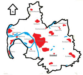
Location of the Strehlhof (bold) within the Volkach municipality
|
|
Strehlhof is a wasteland on the outskirts of the Volkach district of Rimbach in the Lower Franconian district of Kitzingen .
Geographical location
The Strehlhof is relatively centrally located in the Volkach municipality. The associated district of Rimbach is located in the northeast, Eichfeld is much closer to the west. Dimbach is to the southwest , the west is taken up by the Weininsel with the communities of Nordheim am Main and Sommerach. Volkach with the Mainfranken barracks occupies the north-west.
The closest, larger cities are Schweinfurt at a distance of about 22 kilometers, Würzburg is about 25 kilometers away.
In terms of its natural surroundings, the Rimbach district with the Strehlhof lies in the hilly Steigerwald foreland of Neuses , which is part of the Iphofen-Gerolzhofener Steigerwaldvorland within the Mainfränkische Platten .
history
The name of the Strehlhof is probably derived from the stream that flows past the courtyard. The Strehlbach was a body of water that was " lined with cane plants ".
The history of the farm is closely linked to that of the nearby Rimbach, on whose boundary the Strehlhof is located today. In 1230, the Counts of Castell probably owned the farm. In 1235 a witness "Albertus de Strelebach" is handed down. From the ending -bach it can be concluded that the Strehlhof was a Germanic clearing settlement of the 7th or 8th century AD.
In the 15th century the Zollner von der Hallburg acquired the court. In 1497 the farm was owned by the Volkach citizen Hans Klieber, from 1509 it belonged to the knights of Dettelbach . In 1589 the farm was owned by Michael Zöllner. In 1667 the Counts of Schönborn took possession of the court. In 1803 the court came to the Volkach Regional Court . From then on it was part of the Rimbach district. On July 1, 1977 Strehlhof became a district of the city of Volkach.
literature
- Ute Feuerbach: Nobility and Citizenship . In: Ute Feuerbach (Ed.): Volkach 906-2006 . Volkach 2006. pp. 139-141.
- District Administrator and District Council of the District of Kitzingen (Hrsg.): District of Kitzingen . Münsterschwarzach 1984.
- Peter Rückert: Land expansion and desertification of the high and late Middle Ages in the Franconian Gäuland. Diss . Wuerzburg 1990.
- Peter Schneider: Between the Main and Steigerwald (= Mainfränkische Heimatkunde 1) . Wuerzburg 1950.
Web links
Individual evidence
- ^ Bavarian State Office for Statistics and Data Processing (Ed.): Official local directory for Bavaria, territorial status: May 25, 1987. Issue 450 of the articles on Statistics Bavaria. Munich November 1991, p. 366 ( digitized version ).
- ↑ Geography Giersbeck: Map 152 Würzburg , PDF file, accessed on January 8, 2019.
- ^ Schneider, Peter: Between Main and Steigerwald . P. 30.
- ↑ Feuerbach, Ute: Nobility and Citizenship . P. 140.
- ^ Rückert, Peter: Land expansion and desertification of the high and late Middle Ages . P. 258.
- ^ District administrator and district council of the district of Kitzingen (ed.): District of Kitzingen . P. 478.


