
Wine Island
| Wine Island | ||
|---|---|---|
| Waters | Volkacher Mainschleife , Main Canal | |
| Geographical location | 49 ° 50 ′ 31 ″ N , 10 ° 12 ′ 0 ″ E | |
|
||
| length | 6.61 km | |
| width | 4 km | |
| surface | 13.69 km² | |
| Highest elevation | Kreuzberg 287 m |
|
| Residents | 2400 175 inhabitants / km² |
|
| main place | Sommerach | |
 |
||

The Weininsel in the Kitzingen district is an island in the Main that was created through human influence . With around 750 hectares of vineyards, it forms the largest contiguous vineyards in the Franconian wine-growing region and thus comprises 12% of the total area of the wine region .
Location and geography
The island is located between a 12 km long bend in the river southwest of the Mains of Volkach and this abbreviating 6 km long Main channel as puncture between Volkach and Gerlachshausen. The villages of Sommerach and Nordheim am Main as well as the Volkach district of Hallburg are on the resulting island . Three road bridges and a dirt road bridge over the Main Canal and a ferry connection in Nordheim enable access. Another approach is the Nordheim ferry , which runs between Nordheim and the opposite Escherndorf. The uninhabited southern tip of the island belongs to the municipality of Schwarzach am Main , Gerlachshausen and Schwarzenau districts .
In terms of nature, the Weininsel forms a transition zone between two sub-units. The eastern and southeastern part is characterized by large areas of drift sand. This Dimbacher drifting sand area is part of the Kitzinger Mainebene in the Steigerwald foreland, which is counted among the Main Franconian plates . In the west it is part of the Volkacher Mainschleife natural area , which is located in the Middle Main Valley .
Kreuzberg
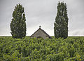
The highest elevation of the Weininsel is the Kreuzberg with 287 m above sea level, which rises almost 100 meters above the river. There is a viewing platform on the summit of the Kreuzberg. The landscape is shaped by viticulture. Here are the well-known vineyards of Nordheimer Kreuzberg , Nordheimer Vögeleins , Hallburger Schlossberg and the Sommerach locations Katzenkopf , Rosenberg and Engelsberg .
Attractions
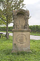
The vineyards are freely accessible and well signposted with a network of hiking trails. There are numerous sights along the way, such as wayside shrines and wayside shrines , fourteen holy shrines , chapels such as the Kreuzkapelle and Hallburg Castle .
Protected areas
Nature reserves
There are some nature reserves on the island:
- Alter Main near Volkach
- Mainaue between Sommerach and Koehler
- Right bank of the Main near Sommerach
- Sand corridors near Volkach, Schwarzach am Main and Sommerach
- Forest at the Hallburg
Geotope
The geotope Eichelsee-Doline am Kreuzberg is located on the Kreuzberg of the Weininsel . The sinkhole sometimes carries water and is heavily muddy during dry periods. It was probably created when a karst cavity broke into the underlying rock layers.
Picture gallery


Kreuzberg viewing platform

Weingarten am Kreuzberg
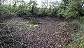
Geotope Eichelsee sinkhole
The Kreuzkapelle
Exposed torture

Wayside shrine near Sommerach


Web links
Individual evidence
- ↑ Geography Giersbeck: Map 152 Würzburg , PDF file, accessed on January 10 of 2019.
- ↑ Geoptop: Eichelsee sinkhole on Kreuzberg (accessed on January 3, 2015)