
Gerlachshausen
|
Gerlachshausen
Schwarzach am Main market
Coordinates: 49 ° 48 ′ 38 ″ N , 10 ° 13 ′ 51 ″ E
|
|
|---|---|
| Height : | 196 m |
| Area : | 5.28 km² |
| Residents : | 341 (1987) |
| Population density : | 65 inhabitants / km² |
| Incorporation : | 1st October 1973 |
| Postal code : | 97359 |
| Area code : | 09324 |
 Location of Gerlachshausen (bold) within the Schwarzach municipality
|
|
 |
|
Gerlachshausen is a district of the market Schwarzach am Main in the Lower Franconian district of Kitzingen in Bavaria . Gerlachshausen was an independent municipality until it merged with five other places in the 1970s. The place can be described as one of the oldest in the area. It probably existed before the Münsterschwarzach Monastery was founded , but it came into its sphere of influence during the Middle Ages.
Today Gerlachshausen forms the northern end of the community. In contrast to the other districts, here, due to the proximity to the Volkacher Mainschleife , larger areas have been placed under nature protection. The so-called Main Canal , which flows into the Main from Volkach in Gerlachshausen, plays an important cultural role for the village. A lock was also built on the canal. The place itself is dominated by the old Agidius Church and its former castle.
Geographical location
Geography and natural location
Gerlachshausen is located in the north of the Schwarzach municipality. In the west the Main flows past the village, with the so-called Altmain and the Main Canal Volkach-Gerlachshausen, which is supposed to overcome the Volkacher Mainschleife , meet at Gerlachshausen . The municipality of Volkach begins further to the north ; the district of Dimbach is closest to Gerlachshausen. In the east, however, Wiesentheid - Reupelsdorf rises some distance away . The south is taken by Münsterschwarzach , with which Gerlachshausen has grown together today. The two districts together with Stadtschwarzach form the center of the community. To the southwest, on the other side of the Main, is Schwarzenau . The north-west, however, is taken by Sommerach .
Closest, larger cities are Volkach, with a distance of about 6 kilometers and Kitzingen, which is about 10 kilometers away. The next big city is Würzburg, about 21 kilometers away .

In terms of its natural surroundings, Gerlachshausen is counted as part of the so-called Schwarzacher valley widening (also Schwarzacher basin). The section of the Middle Main valley is characterized by its flat sections directly adjoining the Main, which were formed by alluvial fans of the streams that flow here. In addition, the Volkacher Mainschleife , which is also located in the Main Valley, rises up to the built-up area with a different geological composition. The Dimbacher drift sand area as part of the Kitzinger Mainebene occupies the north-east of the district.
The district is located in the Maingau climate zone, which is one of the driest and warmest climate zones in Germany. This also explains the viticulture in the area, which today no longer plays an economic role for Gerlachshausen. Geologically, Keuper rocks already predominate on the east side of the Main , which are actually particularly typical for the so-called Steigerwald foreland further east. In addition, drift sand areas with dune formation protrude into the area.
Hydrologically , Gerlachshausen is dominated by the Main or the Main Canal, which has existed since the 1950s. The Main and Main Canal merge at river kilometer 188 in the west of the Gerlachshausen district, right next to the built-up area of the old town. The Etterswasengraben, a tributary of the Main, which rises near Dimbach, and the Hölzersgraben further north also play a certain role. Until the municipal reform in the 1970s and the reallocation of the district, the area of Gerlachshausen ended immediately north of the Schwarzach , which now flows through Münsterschwarzach.
Village structure
The Gerlachshauser district occupies an area of 5.28 km², which makes it the largest unit of area in the municipality. The built-up area takes up only a small part of its area and can be found in the very south. The street village was built in the east of the Main on a flood-free terrace. With the Agidius Church on a hill (196 m above sea level) in the north and the former castle in the southern part of the old town, there are two historical centers. The cemetery was moved to the northern edge of the built-up area in the 20th century.
The settlement of the village , which emerged in the 20th century, has a special feature . It has now grown together with that of Münsterschwarzach and extends along the county road in the south and southeast of the old town. The Ziegelhüttenweg forms the boundary between Gerlachshausen and Münsterschwarzach, which is built on both sides. The even house numbers count to Gerlachshausen, while the odd ones belong to the district of Münsterschwarzach. Both districts also share Gartenstrasse and Sonnenstrasse. The center of the settlement is the roundabout on Abt-Plazidus-Straße further east.
The uninhabited parts of the district vary in landscape. The eastern part, which extends far into the hinterland of the Main, is characterized by large arable areas that stretch as far as the historic Eulenberg (223 m above sea level) or the forests of the Reupelsdorf state forest . In the north, with the Hübnerholz and the Vorderen and Hinteren Holz, the forest areas around Dimbach protrude into the district. The deserted site of the abandoned Lindhof can also be found here. In addition, Gerlachshausen also has a share in the Spessart Forest. While the district ends in the west on the Main, the village on the western side of the Main Canal still has areas on the so-called Weininsel . The Gerlachshausen lock is also located here.
Protected areas
The Gerlachshausen district is the only area in the community of Schwarzach am Main in which areas have been placed under protection by the nature conservation authorities on a larger scale . This is particularly due to the proximity to the Volkacher Mainschleife, which has been relying more on tourism for decades due to its centuries-old cultural landscape and has the greatest density of nature reserves in the Kitzingen district.
The extreme north-west of the district, which lies on the island of wine, is part of the conservation area, Volkacher Mainschleife. The particularly natural section of the Main Valley was placed under protection as early as 1955. The Main Loop is also Fauna-Flora-Habitat (FFH). Large parts of the Main loop have also been declared a bird sanctuary as a section of the Main Valley between Dettelbach and Schweinfurt . The main loop also enjoys the status of a geotope .
The only nature reserve are the sand meadows near Volkach, Schwarzach am Main and Sommerach. They protrude in the extreme north of the district along the state road in the direction of Gerlachshausen and have their center in the Sommeracher Riedwald or in the Spessart. The purpose of the nature reserve is to secure sandy grasslands and sandy grass heaths in their interlocking with forest edges, meadows, arable land, orchards , wetlands and watercourses as well as the protection of sand dunes and drifting sand areas.
history
Prehistory and early history
The Schwarzach Basin has a long history of settlement that goes back to the Palaeolithic . 4000 years ago, corded ceramists from the Neolithic period settled in the area around Schwarzenau. The Urnfield period is represented by several finds around Hörblach. At the same time, the area around Düllstadt was opened up by people. In 1969 a conical neck vessel was discovered in the area surrounding the present-day settlement, which contained the cremated remains of a young man.
From the earlier Iron Age , partition wall shells of the Hallstatt people from the period between 800 and 500 BC have been preserved around Schwarzenau , which can be seen today in the Museum für Franken . Their grave goods were still made of bronze. The district of Gerlachshausen itself becomes tangible for the first time with the discovery of a burial ground from the La Tène period in 1963 . The Celtic tribe of the Bojer established a permanent settlement in Schwarzenau around the turn of the ages. At the same time, Celtic finds were made on the other side of the Main .
The basin was then settled by Alemanni , who disappeared around AD 260. They made way for the Burgundians who settled between the Main and Schwarzach until the 4th century. These Germanic tribal associations also established the name Schwarzach for the flowing water in the center of the valley widening. From the 6th century onwards, Frankish tribes coming from the west began to penetrate the area and slowly displaced the established population.
In the Gerlachshausen district there were also Franconian row graves, which perhaps refer to the time of the Merovingian conquest in the 6th century. The Franks brought Christianity with them to the Main and established the first administrative borders, the so-called Gaue . The later Gerlachshausen lay north of the border river Schwarzachbach and was thus part of the Volkfeld, which arose along the Volkachbach.
Although Gerlachshausen did not appear in documents under this name until the 10th century , the existence of the place is also secured in the centuries before by various back projections. Most of the districts in the Schwarzach Basin were created in the 7th and 8th centuries, including that of Gerlachshausen. In the second half of the 8th century, however, the newly emerging monastery boundary Münsterschwarzach was cut out of that of Gerlachshausen. Gerlachshausen retained the economically important access to the Main.
middle Ages
Gerlachshausen was first mentioned in a document from the year 918. On April 21, 918, King Konrad I confirmed several places in Frankfurt am Main that Bishop Dracholf von Freising, who was also Commendatarabbot of Schwarzach, had given to his monastery. In addition to "Stockheim et Lanckheim", "Gerlachshausen" also appeared in the diploma as equipment for the maintenance of the monks . Dracholf may have belonged to the Mattonen family , who are addressed as the founder family of the Münsterschwarzach monastery and also played a major role in the early days of Gerlachshausen.
In the early and high Middle Ages, the Counts of Castell came into the possession of Gerlachshausen as heirs of the Mattonen . In 1115 Abbot Rupert von Münsterschwarzach finally acquired the village from Heinrich von Gerlachshausen, who was part of the zu Castell family. Heinrich was compensated with a lifelong pension in kind. With the handover to Münsterschwarzach, the right of patronage was also passed to the monastery via the Gerlachshauser pastor.
The original parish of Gerlachshausen can be described as one of the oldest ecclesiastical communities in the Maindreieck and probably has its origin in the Franconian settlement of the area. In the Middle Ages, the parish included the villages of Dimbach , Düllstadt , Hörblach , Kirchschönbach , Mainsondheim , Nordheim (am Main), Reupelsdorf , Schwarzenau and Sommerach . It is possible that the Mattonen initially had the right to appoint the respective pastor. It came through the Counts of Castell as a fief to the bishopric of Würzburg and then to the respective abbot. Bishop Erlung von Würzburg confirmed the transition to Schwarzach at a synod in Würzburg.
The Casteller Counts still kept some goods in the place. This became clear during the feud of 1227/1230, in which Count Rupert zu Castell took action against the Würzburg bishop. After the count's defeat, Gerlachshausen finally came under the control of the bishop. The bailiwick as a military patronage continued to be owned by other nobles. It was not until 1284 that Heinrich Fuchs von Dornheim's widow, Gertrud von Zabelstein , sold the bailiwick to the bishop, which was confirmed in 1306.
Although the Bishop of Würzburg had sovereignty over the monastic property, the monks were able to build up their own monastery property as a media power. Gerlachshausen also belonged to this property, which was confirmed again in 1326 by Bishop Wolfram von Würzburg . In addition to the monks, Casteller Ministeriale , like the Zollner von Hallburg, still owned some goods in the village. The affiliation of the castle on the southern edge of the village, which probably belonged to Heinrich von Gerlachshausen in the 12th century, is unclear.
In the Bavarian War , the authorities belonging to the Gerlachshaus no longer played a major role. The Ansbach Margrave Albrecht Achilles covered the region with war and destruction. In 1461 the margrave quartered himself in the neighboring Sommerach, which was also counted among the monastery villages of Münsterschwarzach. Parts of Gerlachshausen were burned down in the course of the year in order to be able to supply the troops with food.
Early modern age
The German Peasants' War , which began with an uprising in Swabia, marked a change of epoch that also affected Franconia . In 1525, the Stadtschwarzacher also joined the peasantry and plundered the Münsterschwarzach monastery in order not to have to pay the hated taxes to the monks. It is unclear whether Gerlachshausen also took part in the uprisings. The abbot of Münsterschwarzach fled to Gerlachshausen during the plundering of his monastery and was taken in by the “only loyal subject”, Mayor Johann Zirold.
The parish church, which was first expanded in the 15th century and in the past, after the destruction of the Romanesque Egbert basilica , had temporarily also served as the church of the monks ' convent of Münsterschwarzach, experienced a decline in the 16th century. In contrast, the Stadtschwarzacher Church continued to rise. The Gerlach houses were also transferred to Zent Stadtschwarzach by 1589 at the latest .
With the Reformation , denominational conflicts began to affect Gerlachshausen's history. During the Schmalkaldic War, Johann Friedrich I of Saxony stole their grain from the Gerlach houses and in the Second Margrave War the population had to pay 910 guilders as pillage in order to be spared destruction. After all, Abbot Johannes Burckhardt managed to buy their goods in Gerlachshausen from the brothers Stephan, Konrad and Johann Zollner von Hallburg in 1570 , so that now every house in the village belonged to the monastery.
After the death of Abbot Johannes Burckhardt in 1598, the Würzburg Bishop Julius Echter von Mespelbrunn began to work increasingly in Gerlachshausen. In order to strengthen the subjects in the practice of the Catholic faith, he handed the parish of Gerlachshausen into the hands of a world priest , who should also live in the village. At the same time, the church received the real pointed helmet that is still present today. It was not until 1649 that monks from Münsterschwarzach returned to the parish. In 1609 Schwarzenau and Hörblach were separated from the mother parish of Gerlachshausen.
During the Thirty Years War , Gerlachshausen was also frequently plundered and people saved themselves with their belongings in the surrounding forests. However, unlike some neighboring communities, the village was always inhabited. However, in 1636 only one man lived in Gerlachshausen, who lived from fishing. Gerlachshausen was already settled again in 1662, and in 1680 the stone Schwarzach Bridge, located in Gerlachshausen, was completed.
After the parish church in town had become responsible for fewer and fewer parishes in the course of time, it even lost its status in the 18th century and became a branch of the Heiligkreuz parish church in Stadtschwarzach. Although the population wanted to stop the loss of importance with the construction of the nave in the 1750s, Gerlachshausen had become part of the parish Stadtschwarzach by 1791 at the latest. In 1879 the church had to be partially rebuilt after a storm.
Modern times: In Bavaria
The secularization of the Münsterschwarzach monastery at the beginning of the 19th century meant a profound intervention in the economic and social structure of the Schwarzach basin. First the village came to the Electoral Palatinate of Bavaria in 1803 , later followed by an interim period in the Grand Duchy of Würzburg until 1814 . Only then did Gerlachshausen become a rural community in the Kingdom of Bavaria . The district court in nearby Dettelbach was responsible for Düllstadt.

Until the second half of the 19th century, the Gerlachshausen community also consisted of the settlement that had formed before the abolished monastery. It was not until 1864 that the municipality of Münsterschwarzach became independent from Gerlachshausen. It was not until the 1970s that the village around the monastery was given its own district . In 1875 a fire brigade was founded in Gerlachshausen , which, as the oldest military service, became a model for other such institutions in the Schwarzach Basin.
At the beginning of the 20th century, the village was equipped with a post office, which was located in the Gasthaus zum Anker. In 1928 it was converted into a whole post office . Gerlachshausen suffered a total of 24 dead and missing persons in the two world wars of the 20th century. Their names were immortalized on the outside of the Aegidius Church in the form of small epitaphs .
After the Second World War, the construction of the Main Canal between Volkach and Gerlachshausen brought an economic upswing for the population still largely living on agriculture . As early as the 1930s and 1940s, bypassing the narrow Main Loop for shipping had been discussed, with the canal initially going from Gerlachshausen via Obervolkach and Unterspiesheim . The canal that exists today was completed by 1957. The places in its vicinity also benefited economically during the construction period.
In 1965 the one-class elementary school in Gerlachshausen was dissolved and the school association Schwarzacher Becken joined. At the same time, the sewage treatment plant located near Stadtschwarzach was inaugurated . 1973 Gerlachshausen joined the community of Schwarzach as part of the municipal reform. This ended the centuries of independence of the place.
Place name
The place name Gerlachshausen is closely related to the history of the village. The prefix Gerlach- probably refers to the name of a Franconian nobleman who was one of the first to settle here. The name may even give an indication of the founder of the place. The ending -hausen was in vogue during the planned Frankish settlement of the Main Triangle . Gerlachshausen is to be interpreted as the place "to the houses of Gerlach".
In contrast to many places in the vicinity, the name Gerlachshausen has hardly changed in the past. Gerlachshausen appeared in its current name in the document from 918. In the early modern period , the term Geroldshausen was used at times. The Gerlach houses are given nicknames from the surrounding areas . They are called Boon'schaißər ( mfr. Willow shit) and Maüs (mfr. Mice).
Administration and courts
|
The following administrative units were superordinate to Gerlachshausen.
|
Gerlachshausen was judicially subject to the following instances.
|
politics
From mayor to local spokesman
Little is known from Gerlachshausen about the inner village order of the past. The place was probably organized like comparable communities in the surrounding area. The population elected a mayor or chief from among their ranks , who, however, had no powers in relation to the authorities , but merely acted as a contact person. Opposite him stood the much more powerful mayor who was appointed by the landlord.
Some names of Gerlachshausen notables have been handed down in the Middle Ages and early modern times. In 1525, the mayor Johann Zirold was the only loyal subject who stood behind the abbot of Münsterschwarzach. His successor was Johann Georg Seidner in 1648. After the centuries-old independence was lost in the 1970s, the formerly independent towns in the Schwarzach Basin received a local spokesman who was supposed to take care of their representation in the new municipal council .
Population development
At the beginning of the 19th century Gerlachshausen exceeded the number of 200 inhabitants . While the population increased steadily in the first half of the century, the trend was reversed in the second half. The general economic development also played a part in this. In 1900, with a population of 213, a low was reached. In the period that followed, more residents lived in the village again, although the fluctuations were only due to an increase in the birth rate because there was hardly any immigration from the surrounding area.
After the Second World War, the community experienced an influx of refugees and displaced persons . The people only lived in Gerlachshausen for a short time and then moved on. This explains the all-time high of 353 inhabitants in 1946. However, over 300 people always lived in the village in the second half of the 20th century. These numbers were stabilized by the designation of new building areas and the connection with neighboring communities in the 1970s.
| year | Residents | year | Residents | year | Residents |
|---|---|---|---|---|---|
| 1814 | 206 | 1919 | 223 | 1952 | 329 |
| 1840 | 286 | 1933 | 239 | 1961 | 322 |
| 1875 | 274 | 1939 | 261 | 1970 | 337 |
| 1900 | 218 | 1946 | 353 | 1987 | 341 |
Culture and sights
Architectural monuments
Aegidius Church

The Agidius Church forms the northern end of the old town. Its predecessor was one of the first churches in the Steigerwald foreland and soon formed the original parish for the Schwarzach basin. In the 12th century Gerlachshausen and his parish came to the Münsterschwarzach monastery. Until the early modern period , Gerlachshausen lost its parish status and was downgraded to a branch church of Stadtschwarzach.
The church is a large, east- facing hall with an east choir from the beginning of the 15th century. The basement of the five-story tower at the southeast corner of the nave also dates from the 15th century. Around 1600 it was increased and given the characteristic Julius Echter pointed helmet . In 1751 the nave , which still exists today, was added . It was renewed after a storm in 1879.
The interior of the Aegidius Church is dominated by three altars . All three came into the interior of the church in the course of the new nave construction in the 18th century. The oldest part of the furnishings is the late Gothic Pietà on the north choir wall. It was created around the year 1400. The frescoes in the nave, which were probably originally created by the artist Andreas Dahlweiner , are special . After the destruction in the 19th century, Eulogius Böhler carried out the work again.
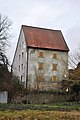
Gerlachshausen Castle
The Gerlachshausen Castle is in the Schloßgasse in the south of the old town. The castle can be described as the oldest manorial building in the Schwarzach Basin. Büll identifies the castle as the bailiff's castle, which already existed in the early Middle Ages at the time of the Münsterschwarzach women's monastery . The building was later converted into an official palace that served the Münsterschwarzach mayor in Gerlachshausen as his residence.
Today the former castle is not very representative. It is built in and the building fabric has been neglected in recent decades. The property is dominated by a two-storey solid building from the 17th century. The steep tailcoat roof is particularly remarkable . The profiled and drilled window frames were partially chipped off, only the portal with skylight on the village side still exists. Remnants of the wall from the previous buildings have been preserved around the building.
Private houses and small monuments
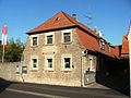
Several houses have been preserved in the Gerlachshausen Altort which are now protected as historical monuments by the Bavarian State Office for the Preservation of Monuments . Such houses exist particularly along Schweinfurter Strasse. They are built on one floor and end with a hipped roof . The houses are unplastered so that the stone masonry is visible. Originally the houses were part of the characteristic Häckerhöfe of the Schwarzach basin, which were built in the 19th century. Most of the goal posts next to the houses were removed. A courtyard gate has only survived in Schweinfurter Straße 110 .
As a Catholic village in Franconia, there are also several wayside shrines around Gerlachshausen, but their existence is still threatened by destruction and accidents. The oldest of these sticks is the torture column in front of the cemetery, which is called Gothic and was built in the Middle Ages. Younger is her top, which is decorated with a modern relief. In front of the castle there is also a relief of the Pietà , which was made in the 18th century and renovated in 2010.
Gerlachshausen Castle

House Schweinfurter Strasse 90
House Schweinfurter Strasse 108

Wayside shrine at the cemetery

Pietà in front of the castle


Gray torture
The gray torture was moved to the cemetery chapel in Sommerach and is no longer a monument in Gerlachshausen. However, its history is closely related to the village and a copy of the torture was set up at the old location near the Gerlachshausen-Sommerach district boundary on the Weininsel. The Graue Marter can be described as the most important wayside shrine in Franconia, its builders are attributed to the Riemenschneider area .
The torture was donated in 1511 by Heinrich Zorn to a mayor of Gerlachshausen. This is evidenced by an inscription on the wayside shrine. The work can be assigned to the master of the Dettelbacher tympanum. The wayside shrine is square and comes from the late Gothic period . The shaft and the cube-shaped attachment show illustrations. The top ends in the form of a Franconian farmhouse with a hipped roof. In the representations on the top, the passion of Christ is shown.
Economy and Infrastructure
economy
Economically, Gerlachshausen has largely merged with the structures of the community of Schwarzach am Main. Similar to the neighboring towns, people commute to the large industrial companies in Kitzingen or Würzburg. In addition still some existing agricultural farms that cultivate land particularly in the east of the district. The Main Canal with the lock , which is passed on site , only plays a subordinate role in economic development.
Historically there were several shell limestone quarries in Gerlachshausen , so that the place was the starting point for the many stone carters. This resulted in a high density of accommodation providers . The proximity to the Main also contributed to this. Since Gerlachshausen had the only district with access to the Main for a long time, the supplies for the monks of the convent in Münsterschwarzach landed here. The stones from the quarries were also shipped from here to Albertshofen .
traffic
Today Gerlachshausen is rather insignificant in terms of traffic. In the early modern period, however, an important escort road ran through the village between Schweinfurt - (Volkach) -Kitzingen. In addition, Gerlachshausen benefited from the ford between Schwarzenau and Münsterschwarzach, which later developed into a ferry between Schwarzenau and Stadtschwarzach and became an important main crossing point. For a long time, Gerlachshausen, as the mother parish, had to be regularly reached by the residents of its branches.
Since 1997 the state road 2271 has been running as a bypass road past the village center of Gerlachshausen in the west of the village. It is the successor to the early modern Geleitstrasse and mediates in the nearest medium- sized centers Kitzingen and Volkach. In addition, the district roads KT 11 and KT 29 lead through the Gerlachshausen district. Coming from Sommerach, the district road KT 29 joins the state road and only runs through the corridors of Gerlachshausen as a local connection in the north-west of Sommerach.
The district road KT 11, on the other hand, forms the backbone of the community of Schwarzach am Main and, as the main road, connects the places Gerlachshausen-Münsterschwarzach-Stadtschwarzach with each other, whereby it is called Schweinfurter Strasse in the places. The connection to Dimbach in the northeast is ensured by a road that is only used locally. The historic route to Ulberg or Volkach is now part of the extensive Main Cycle Route .
Gerlachshausen has two bus stops in the elongated town center (church and Wehrgasse), which are served by two OVF lines. These are line 8108 (Würzburg-Dettelbach-Nordheim am Main) and 8110 (Kitzingen-Dettelbach / Schwarzach-Volkach). The Main and the Main Canal only play a subordinate role for traffic today, even though Gerlachshausen can also be considered the historical loading center of the Münsterschwarzach Abbey. The next Mainland can be found in Volkach.
education
Today Gerlachshausen no longer has its own school. Since 1965, the children are in the Verbandsschule taught Schwarzacher Basin, one of the first national schools in Lower Franconia was and was built near Stadtschwarzach. The old school house in front of the church dates from the 19th century and provided space for the students from Münsterschwarzach and Gerlachshausen. The two communities had merged since 1938. In Gerlachshausen, the children were taught one class.
Gerlachshausen is now in the district of the Dettelbach-Volkach secondary school network and is assigned to the Rudolf-von-Scherenberg Middle School in Dettelbach. Secondary schools can be attended with the girls' secondary school in Volkach and the secondary school in Dettelbach. There are high schools in Münsterschwarzach ( Egbert-Gymnasium ), Volkach- Gaibach ( Franken-Landschulheim Schloss Gaibach ), Wiesentheid ( Steigerwald-Landschulheim ) and Kitzingen ( Armin-Knab-Gymnasium ).
Associations and associations
Today there are only two associations in the village. The oldest is the volunteer fire brigade , which is organized in a fire brigade association. It is the oldest weir in the Schwarzach Basin and was founded on May 15, 1875. In 1880 it was briefly converted into a compulsory fire brigade . In the 2000s, the fire brigade moved into today's fire station . The Gerlachshausen fire brigade today has a portable pump vehicle (TSF + PA). Acting commandant is Annette Hillenbrand.
The Spielvereinigung (SpVgg) Münsterschwarzach-Gerlachshausen is much younger . It was founded in its current form on January 31, 1950, with both locations playing together in the DJK Münsterschwarzach as early as 1929 . The SpVgg sports field is close to the canal lock. In May 1970, one was basketball department sent founds, previously only a football team had passed. In 1971 a gymnastics group was founded in the club. Today there is also a children's gymnastics group.
literature
Literature about Gerlachshausen
- Franziskus Büll, Josef Gerlach: Schwarzach am Main in old views . Zaltbommel NL 1991.
- Hans A. Dresch: Sources and reports on the history of the market town of Schwarzach am Main. Part 1 . Schwarzach am Main 1986.
- Voluntary Fire Brigade Münsterschwarzach (Ed.): Commemorative publication 100 years of the Voluntary Fire Brigade Münsterschwarzach. 30 years of SpVgg Münsterschwarzach-Gerlachshausen. 4th-7th July 1980 . Münsterschwarzach 1980. o. P.
- Erwin Probst: Vogt and Lord of the village and field. Contributions to the history of legal life in the former monastery Blackachian bailiwick villages . In: Studia Suarzacensia. Contributions to the history of the Münsterschwarzach Abbey on the occasion of the 50th anniversary of its resettlement (= Würzburg diocesan history sheets 25th vol.) . Münsterschwarzach 1963. pp. 145–168.
- Peter A. Süß: Gerlachshausen . In: Jesko Graf zu Dohna (Ed.): Kulturpfad. In the footsteps of the Counts of Castell . Münsterschwarzach 2004. pp. 98–99.
- Hugo Walter: The breakthrough Volkach-Gerlachshausen . In: Ute Feuerbach (Ed.): Our Main Loop. 1993-2007 . Volkach 2008. pp. 231-244.
Other literature used
- Hans Bauer: District of Kitzingen. An art and culture guide . Market wide 1993.
- Franziskus Büll: The Monastery Suuarzaha. A contribution to the history of the Münsterschwarzach women's monastery from 788 (?) To 877 (?) . Münsterschwarzach 1992.
- Monika Fritz-Scheuplein, Almut König, Sabine Krämer-Neubert, Norbert Richard Wolf: Dreidörfer fools stand on three rafters. Ortnecknames in Lower Franconia . Würzburg 2012.
- Rudi Krauss: place names in the district of Kitzingen . In: In: Yearbook for the district of Kitzingen 2012. In the spell of the Schwanberg . Dettelbach 2012. pp. 233-244.
- Gabriel Vogt: Market Schwarzach am Main . In: District Administrator and District Council of the District of Kitzingen (Hrsg.): District of Kitzingen . Münsterschwarzach 1984. pp. 494-504.
Web links
Individual evidence
- ↑ a b Bavarian State Office for Statistics and Data Processing (Ed.): Official local directory for Bavaria, territorial status: May 25, 1987 . Issue 450 of the articles on Bavaria's statistics. Munich November 1991, DNB 94240937X , p. 366 ( digitized version ).
- ^ Büll, Franziskus: Das Monasterium Suuarzaha . P. 17.
- ^ Büll, Franziskus: Das Monasterium Suuarzaha . P. 35 and 39.
- ^ Büll, Franziskus (among others): Schwarzach am Main in old views . Picture 3.
- ^ Vogt, Gabriel: Schwarzach am Main . P. 500.
- ^ Dresch, Hans A .: Sources and reports on the history of the market town of Schwarzach am Main . P. 30.
- ↑ Suess, Peter A .: Gerlachshausen . P. 98.
- ↑ Suess, Peter A .: Gerlachshausen . P. 99.
- ^ Probst, Erwin: Vogt and Lord to village and field . P. 164.
- ^ Dresch, Hans A .: Sources and reports on the history of the market town of Schwarzach am Main . P. 71.
- ↑ Suess, Peter A .: Gerlachshausen . P. 99.
- ^ Büll, Franziskus (among others): Schwarzach am Main in old views . Pic 6.
- ^ Vogt, Gabriel: Schwarzach am Main . P. 500
- ^ Walter, Hugo: The breakthrough Volkach-Gerlachshausen . P. 244
- ^ Krauss, Rudi: place names in the district of Kitzingen . P. 242 f.
- ^ Fritz-Scheuplein, Monika (among others): Ortsnecknames in Lower Franconia . P. 52 and 45.
- ^ Dresch, Hans A .: Sources and reports on the history of the market town of Schwarzach am Main . P. 17.
- ↑ Bavarian State Statistical Office (Hrsg.): Historical municipality register: The population of the municipalities of Bavaria in the period from 1840 to 1952 (= contributions to Statistics Bavaria . Issue 192). Munich 1954, DNB 451478568 , p. 205 , urn : nbn: de: bvb: 12-bsb00066439-3 ( digitized version ).
- ↑ Bavarian State Statistical Office (Hrsg.): Historical municipality register: The population of the municipalities of Bavaria in the period from 1840 to 1952 (= contributions to Statistics Bavaria . Issue 192). Munich 1954, DNB 451478568 , p. 214 , urn : nbn: de: bvb: 12-bsb00066439-3 ( digitized version ).
- ↑ Bavarian State Statistical Office (ed.): Official city directory for Bavaria, territorial status on October 1, 1964 with statistical information from the 1961 census . Issue 260 of the articles on Bavaria's statistics. Munich 1964, DNB 453660959 , Section II, Sp. 882 ( digitized version ).
- ^ Bavarian State Statistical Office (ed.): Official place directory for Bavaria . Issue 335 of the articles on Bavaria's statistics. Munich 1973, DNB 740801384 , p. 188 ( digitized version ).
- ^ Büll, Franziskus (among others): Schwarzach am Main in old views . Pic 5.
- ↑ OVF: Gerlachshausen timetable , accessed on February 28, 2020.
- ↑ Münsterschwarzach volunteer fire brigade (ed.): Festschrift 100 years / 30 years . o. S.
- ^ Büll, Franziskus (among others): Schwarzach am Main in old views . Pictures 4 and 47.
- ↑ Gerlachshausen Voluntary Fire Brigade: Fire Brigade Chronicle , accessed on February 28, 2020.
- ↑ KFV Kitzingen: Gerlachshausen Voluntary Fire Brigade , accessed on February 28, 2020.
- ↑ Münsterschwarzach volunteer fire brigade (ed.): Festschrift 100 years / 30 years . o. S.
- ↑ SpVgg Münsterschwarzach / Gerlachshausen: Homepage , accessed on February 28, 2020.
