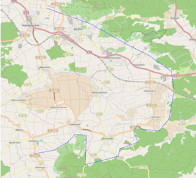
Hellmitzheim Bay
| Hellmitzheim Bay | |
|---|---|
| Possenheim in the flat Hellmitzheim Bay | |
| Systematics according to | Handbook of the natural spatial structure of Germany |
| Greater region 1st order | Layer level land on both sides of the Upper Rhine Rift |
| Greater region 2nd order | Southwest German layer level country |
| Greater region 3rd order | Swabian-Franconian Gau |
| Main unit group | 13 → Main Franconian plates |
| About main unit | 137 → Steigerwald foreland |
| 4th order region (main unit) |
137.1 → Iphofen-Gerolzhofener Steigerwaldvorland |
| Natural space |
137.10 → Hellmitzheim Bay |
| Natural area characteristics | |
| Landscape type | open level |
| Geographical location | |
| Coordinates | 49 ° 40 ′ 10.9 " N , 10 ° 18 ′ 55.4" E |
| Local area | Dornheim , Hellmitzheim , Hüttenheim in Bavaria , Markt Herrnsheim , Mönchsondheim , Nenzenheim , Possenheim |
| local community | Market Einersheim , Iphofen , Seinsheim , Willanzheim |
| circle | Kitzingen district |
| state | Bavaria |
| Country | Germany |
The Hellmitzheim Bay is a small-scale natural spatial unit (5th order) with the order number 137.10 in the Lower Franconian communities of Iphofen , Markt Einersheim , Seinsheim and Willanzheim in the Kitzingen district .
location
The Hellmitzheim Bay (137.10) forms a sub-unit within the main unit Iphofen-Gerolzhofener Steigerwaldvorland (137.1). It is part of the Steigerwald foreland (137) and thus a natural area in the main unit group of the Mainfränkische Platten . In the north, the area is bounded by the Schwanberg foreland (137.11), in which the area is already much steeper in the direction of the Steigerwald. In the east and south, the northern Steigerwald (115) itself forms the boundary, with the Schwanberg step (115.00) following to the northeast , while the subunit Frankenberg (115.01) begins to the southeast . The west is largely dominated by the Ifftal area (130.01) as the natural area of the Gäuf areas. Only in the north-west does the Mainbernheimer level (137.00) connect to the Hellmitzheimer Bucht.
The natural area is relatively compact and can be easily distinguished from the neighboring areas due to its appearance. The center is formed by the southern districts of Iphofen around Mönchsondheim and the eponymous Hellmitzheim , with Dornheim in the center . In addition, the two districts of Willanzheim are located within the bay, the main town is already in the Mainbernheim plain. In the far north the area is crossed by the Würzburg-Nuremberg railway line .
Landscape characteristics
The landscape of Hellmitzheim Bay presents itself as an open plain , between the towering mountain spurs of the Steigerwald. The area is poorly reliefed and pushes itself far against the receding Steigerwald step. The natural area is severely cut in places by smaller streams, numerous streams arise here, including the Kirchbach , Moorseebach , Siechhausbach and the Zettelbach . The catchment area of the Breitbach formed smaller notch valleys .
The area is characterized by its centuries-old use by humans. Small and medium-sized arable farms still exist here today, while smaller forest areas permeate the bay. Medium forest management with guarding areas is still carried out here. The potential natural vegetation (without human intervention) would produce extensive mixed forests with bedstraw, oaks and hornbeams , only the ascent of the Steigerwald would be covered with oaks and firs .
Protected areas
The natural area is interspersed with a large number of protected areas of almost all protection categories. Smaller parts are part of the landscape protection area within the Steigerwald Nature Park (formerly a protection zone) , the area of which is also occupied by bird sanctuaries and fauna and flora habitats . Further areas for bird protection are around Markt Herrnsheim and Hüttenheim in Bavaria .
Geology and tectonics
The Hellmitzheimer Bay made an old gate that still in the Neogene the river systems of the former Mains (so-called Wurzburg and Schweinfurt Main) to the southeast to the Danube drained out. Today the natural area forms the watershed between the Main and Regnitz . Unlike many neighboring areas, the bay is not so low in precipitation. This is due to a so-called precipitation road, which extends from Ochsenfurt over the Mainbernheimer level to the Schwanberg .
Geologically, loess-covered Lettenkeup soils predominate in Hellmitzheim Bay . This loess cover separates the area from the natural areas of the Kitzinger Main Plain with its drifty sand soils . The area is interspersed with gypsum keuper soils, and lower Keuper sections are less common. This clearly distinguishes them from the sandstone Keuperböden of the eastern Steigerwald.
See also
literature
- Karl-Albert Habbe: The natural space units on sheet 153 Bamberg 1: 200,000 - A bundle of problems and a suggested structure . In: Mitteilungen der Fränkische Geographische Gesellschaft Vol. 50/51 for 2003/2004 . Erlangen 2004. pp. 55-102.
- Horst Mensching, Günter Wagner: The natural spatial units on sheet 152 Würzburg (= geographical land survey 1: 200,000 natural spatial structure of Germany) . Bad Godesberg 1963.
Web links
Individual evidence
- ↑ Geography Giersbeck: Map 152 Würzburg , PDF file, accessed on 9 February of 2019.
- ↑ Mensching, Horst (among others): The natural space units on sheet 152 Würzburg . P. 33.
- ^ Habbe, Karl-Albert: The natural space units on sheet 153 Bamberg 1: 200,000 . P. 85 (map).
- ↑ Mensching, Horst (among others): The natural space units on sheet 152 Würzburg . P. 34.

