
Hellmitzheim
|
Hellmitzheim
City of Iphofen
Coordinates: 49 ° 40 ′ 7 ″ N , 10 ° 19 ′ 32 ″ E
|
|
|---|---|
| Height : | 314 m |
| Residents : | 399 (Oct 31, 2008) |
| Incorporation : | January 1, 1972 |
| Postal code : | 97346 |
| Area code : | 09326 |
 Location of Hellmitzheim (bold) in the Iphöfer municipality
|
|
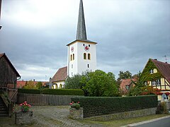
 The church in Hellmitzheim
|
|
Hellmitzheim is a district of the city of Iphofen in the east of the Lower Franconian district of Kitzingen .
geography
location
Hellmitzheim is located in the east of the Iphöfer urban area on the western edge of the southern Steigerwald near the border with Middle Franconia . To the north of the place the railway line Nürnberg – Würzburg passes it and behind it the B 8 , which touches the neighboring Possenheim , in the south Dornheim an der St 2418 is the next place and in the west Mönchsondheim , all of which are districts of Iphofen. Behind the district border in the east begins the district of Neustadt an der Aisch-Bad Windsheim , while in the northwest lies the municipality of Markt Einersheim, which is almost entirely enclosed by the Iphöfer area .
The closest larger cities are Neustadt an der Aisch in the southeast about 22 kilometers away and Kitzingen in the opposite direction , about 14 kilometers away. Nuremberg is about 75 km to the east and Würzburg 40 km to the west.
Hellmitzheim Bay

The Hellmitzheim Bay area is named after the town of Hellmitzheim . This almost flat step-edge bay is covered by fertile farmland, is framed on three sides by the wooded mountain ranges of the Steigerwald and opens on the fourth westward to the Main Valley .
The bay is part of the subunit Steigerwaldvorland of the main natural spatial unit Mainfränkische Platten , a largely unforested landscape that extends far into the western Steigerwald, which itself already belongs to the higher middle Keup level of the south-west German layer level country . In the Hellmitzheim Bay there is gypsum keuper , in the deeper parts also Unterkeuper . The overlying sandstone keuper then sets in at the tree line encircling the eastern arch and at the same time the LSG landscape protection area within the Steigerwald nature park (formerly protection zone) LSG-00569.01 .
The highest elevations of the surrounding forest areas are in the north of the Schwanberg ( 456 m above sea level ) and the Scheinberg ( 498 m above sea level ), the highest positions in the bay itself are a little over 330 m above sea level. NHN . Apart from the valley basins, the terrain is nowhere below 290 m above sea level. NHN . The Breitbach, which drains the bay, rises on its southern edge and leaves it in its valley at about 240 m above sea level. NHN .
Numerous streams arise in the area, including the Kirchbach , Moorseebach , Siechhausbach and Zettelbach .
Waters

Hellmitzheim is located on the Kirchbach , a right tributary of the Breitbach. Its headwaters are located east of the village at the beginning of a narrow corridor bridge traversed by the B 8 into the neighboring upper Bibart valley and in the surrounding forest, including the Mönchsondheimer wood . It flows past the gypsum karst spring Grundlos and leaves the place again in a westerly direction, where it then drives two mills belonging to the place in a remote location.
Former districts
Until the incorporation in 1972, Hellmitzheim included the following places:
history
The village was first mentioned in the sources in 1225. However, it was probably founded much earlier. Typical £ row grave fields from the Merovingian era , which were discovered in the Hellmitzheim grave field near the village, indicate that Hellmitzheim was settled as early as the Franconian conquest in the 6th or 7th century. The burial ground is considered to be the “(...) most important cemetery of the early Middle Ages” in the region.
Hellmitzheim rose to a center as early as the 14th century when the main court of the Duchy of Würzburg was relocated here. In 1414 the Lords of Limpurg and the Counts of Castell divided the village. After the Casteller waived, the village remained in the hands of the Counts of Limpurg-Speckfeld from 1435 to 1803 and later, with the death of the last taverns in 1705 and 1713, in the hands of the Counts of Rechteren-Limpurg .
During the Thirty Years War , the Evangelical Lutheran parish was badly affected. In 1628 the Iphöfer Amtskeller Johann Ott attacked the villages Hellmitzheim, Possenheim and Einersheim with some soldiers. He expelled all Lutheran pastors and teachers from the villages. However, Hellmitzheim stayed with the new faith.
In the first Reichstag election campaign in 1932, the Neustadt merchant Richard Schwab , who came from Lauf, led a propaganda march from Hellmitzheim to Iphofen on behalf of the Scheinfeld district of the NSDAP with the Nuremberg city council and later SS-Sturmbannführer Hans Bäselsöder.
During the Second World War , large parts of the old village were destroyed, the church burned down to the ground, the town hall, rectory and fortified church were completely destroyed. The Americans dropped bombs on the village on April 11, 1945. Reconstruction continued in the post-war period and in 1967 was rewarded with the title “Most beautiful village in the Scheinfeld district”. Hellmitzheim has been part of the newly created large community of Iphofen since 1972.
Church history
Some of the parishes of the Evangelical Lutheran Dean's Office Markt Einersheim , to which the Hellmitzheim parish office belongs, have a church history that goes back to the Reformation . Hellmitzheim belonged to the county of Limpurg-Speckfeld. Protestant teaching was introduced there between 1540 and 1555. During the Counter Reformation, the parishes became Catholic again in March 1627. Most of the population remained Protestant. The parish of Hellmitzheim supported Dornheim on a charitable basis.
Incorporation and district membership
On January 1, 1972, the previously independent municipality of Hellmitzheim was incorporated into Iphofen as part of the municipal reform . Until the district reform , which came into force on July 1, 1972, Hellmitzheim belonged to the Scheinfeld district and thus to Middle Franconia .
Culture and sights
Buildings
Evangelical parish church
The choir tower with its loopholes probably dates back to the 15th century, the nave was added in the 16th century. The church and the fortified church around it were almost completely destroyed in 1945. The old equipment burned during the bombardment and was replaced by modern pieces. The wooden crucifix in the choir dates from 1953. The fortified church that used to surround the building was not rebuilt either.
Community house Hellmitzheim
The listed building Mönchsondheimer Straße 8 (formerly house number 85) is certainly the most beautiful half-timbered house in Hellmitzheim. It was probably built at the end of the 16th century. The original furnishings from the German Renaissance are almost entirely present on the upper floor. The grown gypsum stone floor on the ground floor and the vaulted cellar carved from the solid stone are also still preserved.
In 1987 the owner at the time wanted to tear down the house. As a result, on April 21, 1988, the support association for the preservation of a listed farmhouse was founded . In April 1995 the historic half-timbered house was ceremoniously handed over to the Hellmitzheimers after extensive renovation as a town house .
Several so-called stable houses characterize the village. They mostly originated in the 18th or 19th century. A hunting lodge belonging to the Counts of Limpurg-Speckfeld, an 18th century fountain house and a simple stone bridge over the Kirchbach have also been preserved.

Hellmitzheim rectory
Hellmitzheim church from the east
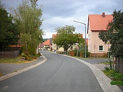
Helmboldstrasse Hellmitzheim


Natural monuments
To the northeast of Hellmitzheim, the karst springs, designated as a natural monument, emerge Grundlos from the Gipskeuper. Both sources and parts of the stream are under nature protection . The source is identified by the Bavarian State Office for the Environment as geotope 675Q001.
legend
Similar to Geiselwind, there is also a story in Hellmitzheim about the former size of the place.
A legend in Hellmitzheim alludes to the former greatness of Hellmitzheim. Accordingly, the village should once have been an independent city with all rights . Large parts of the city would have been located in the west of today's village in particular; today only the Obere Dorfmühle is located there. The city is said to have been looted and burned down during the Thirty Years War . The legend probably goes back to the long history of settlement in the village. So one dug up artefacts from bygone times over and over again.
music
In Hellmitzheim there are several choirs and brass bands (Trombone Choir Hellmitzheim, Hellmsemer Dorfmusikanten, church choir, children's choir "Musical Flummies").
Sports
The sports club ASV Hellmitzheim, founded in 1974, has sports, soccer and tennis courts and a sports center with a fitness and gymnastics room. In Iphofen there is an indoor swimming pool, in the neighboring market Einersheim an outdoor pool.
societies
- ASV Hellmitzheim
- Hellmitzheim volunteer fire brigade
- Soldier comradeship Hellmitzheim
- Evangelical rural youth
- Association for the preservation of a listed farmhouse
- Friends of Hellmitzheim-Antau
Traditionally on the first Sunday in October, the parish fair takes place with a parade of the local boys.
Transport and infrastructure
Hellmitzheim is located on State Road St 2418 Würzburg - Bundesstraße 8 and is very well connected to local traffic by the B 8. The Nuremberg – Würzburg railway touches the northern end of the village. Until 1982 Hellmitzheim had a stop on this route, which was abandoned in the course of the expansion measures at that time. Since then, the Hellmitzheim transfer point has existed in Mönchsondheimer Holz.
The rich gypsum deposits, especially in the area between the railway line and the main road, were mined in opencast mining at the beginning of the 20th century. Starting at the level of the former train station and, almost a hundred years later, near the Mönchsondheimer Holz forest to the east , the areas were exploited and later renatured. Up until the 1960s, a gypsum plant was in operation north of the village, which exploited and processed the local gypsum deposits. After the takeover by the gypsum and building materials company Knauf Gips KG , the plant was shut down and later demolished.
In addition to the remaining farms, there are craft businesses such as carpentry, blacksmiths and a sawmill.
The place has a two-group kindergarten, a branch of the VR Bank Kitzingen , the sales point of a bakery and three restaurants, some of which are open daily.
Personalities
- Johannes Crellius (1590–1633), theologian and educator
- Otto Stapf (1890–1963), German infantry general
- Otto Weigand (1891–1968), civil servant and member of the state parliament.
literature
- Hans Bauer: District of Kitzingen. An art and culture guide . Market wide 1993
- Andreas Brombierstäudl: Iphofen. A small Franconian town through the centuries . Iphofen 1983.
- Matthias Simon: Historical Atlas of Bavaria . Ecclesiastical organization, the Protestant Church. Commission for Bavarian State History, Munich 1960.
- Johann Ludwig Klarmann, Karl Spiegel: Legends and sketches from the Steigerwald. Reprint of the 1912 edition . Neustadt an der Aisch 1982.
- Wolfgang Osiander: The Reformation in Franconia . Andreas Osiander and the Franconian reformers. Schrenk-Verlag, Gunzenhausen 2008, ISBN 978-3-924270-55-1 .
See also
Web links
- Map of Hellmitzheim and the surrounding area on: Bavaria Atlas of the Bavarian State Government ( information )
- Hellmitzheim: Hellmitzheim, a Franconian village , accessed on April 28, 2015
Individual evidence
- ↑ Iphofen.de ( page no longer available , search in web archives ) Info: The link was automatically marked as defective. Please check the link according to the instructions and then remove this notice. , Iphofen district brochure, accessed on April 28, 2015
- ↑ a b Fritz Ortner: Illustrated guide through market Einersheim and its history . Ed .: Markt Markt Einersheim. Hügelschäffer printing works, Mainbernheim 1986.
- ↑ BfN landscape profile Steigerwaldvorland ( memento of the original from June 13, 2015 in the Internet Archive ) Info: The archive link was automatically inserted and not yet checked. Please check the original and archive link according to the instructions and then remove this notice. Federal Agency for Nature Conservation, accessed on June 11, 2015
- ↑ World Database on Protected Areas - LSG within the Steigerwald Nature Park (formerly protection zone) (English)
- ↑ Two new grave finds from the Merovingian burial ground at Hellmitzheim, Lüdemann, Heide (1993) In: The archaeological year in Bavaria (1992) pp. 128–130
- ↑ Brombierstäudl, Andreas: Iphofen . P. 359.
- ^ Bauer, Hans: District of Kitzingen . P. 112
- ↑ Brombierstäudl, Andreas: Iphofen . P. 359.
- ^ Wolfgang Mück: Nazi stronghold in Middle Franconia: The völkisch awakening in Neustadt an der Aisch 1922–1933. Verlag Philipp Schmidt, 2016 (= Streiflichter from home history. Special volume 4); ISBN 978-3-87707-990-4 , p. 240.
- ↑ Brombierstäudl, Andreas: Iphofen . P. 360.
- ^ Wilhelm Volkert (ed.): Handbook of Bavarian offices, communities and courts 1799–1980 . CH Beck, Munich 1983, ISBN 3-406-09669-7 , p. 565 .
- ↑ Geotope: Gypsum karst springs Small and Large Grundlos (accessed on June 10, 2015; PDF; 291 kB)
- ↑ Klarmann, Johann Ludwig (among others): Legends and sketches from the Steigerwald . P. 113.
- ↑ Heller, Florian: Geological investigations in the area of the Franconian base gypsum, Naturhistorische Gesellschaft Nürnberg, 1930 (accessed on June 13, 2015; PDF; 5 MB)

Birklingen | Bruckhof | Domherrnmühle | Dorfmühle (upper) | Dornheim | Fischhof | Forsthaus | Gumpertsmühle | Hellmitzheim | Herrgottsmühle | Hollow Well Mill | Iphofen | Landthurm | Mönchsondheim | Mill (lower) | Nenzenheim | Kidney grinder | Possenheim | Schwarzmühle | Seehof | Vogtsmühle | Waldhof