
List of architectural monuments in Iphofen
The monuments of the Lower Franconian town of Iphofen are compiled on this page . This table is a partial list of the list of architectural monuments in Bavaria . The basis is the Bavarian Monument List , which was first drawn up on the basis of the Bavarian Monument Protection Act of October 1, 1973 and has since been managed by the Bavarian State Office for Monument Preservation . The following information does not replace the legally binding information from the monument protection authority. This list reflects the update status as of May 1, 2020 and contains 217 architectural monuments.

Ensembles
Iphofen old town ensemble
Iphofen, a Franconian original parish , is one of the royal estates that Karlmann gave to the newly founded diocese of Würzburg in 741 to furnish it. The place remained mainly Würzburg until the transition to Bavaria in 1803. At the end of the 13th century, under Bishop Manegold of Neuchâtel, it was elevated to the status of a town and expanded to a fortress , excluding the moat district , which was then under Hohenlohe rule , a part of the settlement that was only included in the walling at the end of the 14th century. The separating section of the fortification has remained recognizable to this day and the combination of two slightly offset districts gives the city outline its peculiar irregularity. In the southern burial district and in the area of the St. Martin cemetery outside the fortification, the originally village settlement is to be found, of which there are no structural traces except for the plague gate . While the Maxstraße route via Julius-Echter-Platz and Bahnhofstraße has to be understood as a guideline in the “Gräberviertel”, the city center is structured by an east-west facing ladder system, which, however, already has its geometric clarity, as prevailed in Gothic foundations Thirty Years War has lost. The three city gates fit into this network of paths, but only allow the main axes to be broken and twisted several times. Approximately in the middle of the city center is the long rectangular market square, which communicates on a narrow side with the west-east thoroughfare and which narrows into the church square. The Gräbenviertel has its own space in Julius-Echter-Platz. The place, which mainly lives from viticulture and agriculture, shows a predominantly village character. The development consists only on the main streets of a closed row of gable and eaves summer houses according to urban-looking parcelling, but mainly from the side by side of agriculturally used courtyards. A few larger courtyards, mostly former branches of monasteries, are scattered within the small-scale development . Apart from the fortifications, which have been preserved without interruption, which with their towers and gates give the city silhouette a special conciseness, the monumental focal points are assigned to the plaza. The representative baroque facade of the town hall dominates the market square, which develops in spatial staggering, in visual interplay with the late Gothic choir of the town parish church rising behind it and towering above the slender church tower . Julius-Echter-Platz, on the other hand, is stretched between the late Renaissance building of the citizen's hospital and the late and post-Gothic Holy Blood Church. Boundary: city fortifications including the moat zone. File number E-6-75-139-1.
City fortifications
The fortification belt with moat and rampart around the old town and the wall extension from the end of the 14th century, which included the moat quarter, have been preserved throughout with four towers, seven tower projections and three city gates, which were built in the 15th and 16th centuries. Century were expanded.
For the outer city wall, compare the following house and corridor numbers: Aegidiengasse 1,2,3,4, and 10 (first wall ring), Bahnhofstraße 20 and 24 (second wall ring), Julius-Echter-Platz 3,6 and 7 (second wall ring), Kirchgasse 1 and 2–32 (even numbers, first wall ring), Kirchplatz 4,5 and 6 (first wall ring), Lange Gasse 36 (first wall ring), Maxstraße 3 to 17 (odd numbers, second wall ring), Obere Gasse 2 to 10 (even numbers, first wall ring), Pfarrgasse 2, 3, 10 and 12 (first wall ring), and Untere Gräbengasse 2 to 10 (even house number, second wall ring). Furthermore, the following field numbers: 74/2, 239/2 (both first wall ring), 257/2, 292/2, 294/2, 294/3 and 294/4 (second wall ring).
For the inner city wall (also the first wall ring), compare the following house and floor numbers: Ludwigstraße 14, Maxstraße 24, Obere Gasse 2 and 4, Stöhrsgasse 1 and 5 and floor number 235/2.
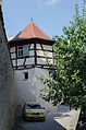
For the city gates, city towers and defense towers, compare the following house and corridor numbers: Eineheimer Straße 2 (gatekeeper house, to Einersheimer Tor), Julius-Echter-Platz 4 and 5 (Mainbernheimer Tor), Kanalgasse 9 (Henkersturm), Kirchgasse 1 (Hackerturm), Lange Gasse 35 (Einersheimer Tor), Maxstraße 19 (Hirtenturm), Pfarrgasse 1 (lunch storm), Rödelseer Straße 1–3 (Rödelseer Tor), Untere Gräbengasse 12, area no. 293 (Zehntturm and Pest- or Totentor), bei Pfarrgasse 2, Fl.Nr.55/2 (Bürgerurm) and bei Obere Gasse 10, Fl.Nr.216/3 (Owl Tower) File number: D-6-75-139-1.
Starting at Rödelseer Tor, the city fortification consists of the following objects in a clockwise direction.
| location | object | description | File no. | image |
|---|---|---|---|---|
| Rödelseer Tor 1, 3 ( location ) |
Rödelsee Gate | Half-timbered extensions with gatekeeper houses and residential building, 15th and 17th / 18th centuries. century | D-6-75-139-135 |
 more pictures |
| Rödelseer Tor ( location ) |
Rödelsee Gate | One-yoke arch bridges over the outer and inner trenches | D-6-75-139-135 | |
| Rödelseer Tor 2 ( location ) |
Rödelsee Gate | Vorwerk (barbican) from a formerly open semicircular tower with a conical roof and archway, 1455/56 | D-6-75-139-135 |
 more pictures |
| Pfarrgasse 1 ( location ) |
Inner gate tower | Square tower made of quarry stone over a pointed arched passage, pointed helmet, 15./16. century | D-6-75-139-128 |
 more pictures |
- Pfarrgasse 3, city wall ( location )
- Kirchplatz 5, city wall ( location )
- Kirchgasse 32, city wall ( location )
- Kirchgasse 30, city wall ( location )
- Kirchgasse 28, city wall ( location )
- Kirchgasse 26, city wall ( location )
- Kirchgasse 24, city wall ( location )
- Kirchgasse 22, city wall ( location )
- Kirchgasse 20, city wall ( location )
- Kirchgasse 18, city wall ( location )
- Kirchgasse 16, city wall ( location )
- Kirchgasse 14, city wall ( location )
- Kirchgasse 12, city wall ( location )
- Kirchgasse 10, city wall ( location )
- Kirchgasse 8, city wall ( location )
- Kirchgasse 6, city wall ( location )
- Kirchgasse 3, city wall ( location )
- Kirchgasse 2, city wall ( location )
- Kirchgasse 1, city wall ( location )
- Kirchgasse 1, Hackerturm, converted defense tower with half-timbered upper floor, 18th century ( location )

City wall Kirchgasse 1

| location | object | description | File no. | image |
|---|---|---|---|---|
| Lange Gasse 35 ( location ) |
Einersheimer Tor | City gate, late medieval gate tower and porch, with a round corner core, the core of the 15th century, the upper parts of the first half of the 16th century | D-6-75-139-73 |
 more pictures |
- Lange Gasse 36, city wall ( location )
- Obere Gasse 8, city wall ( location )
- Obere Gasse 8, Eulenturm ( location )

Owl Tower

- Obere Gasse 6, city wall ( location )
- Obere Gasse 4, city wall ( location )
- Obere Gasse 2, city wall ( location )
- Ludwigstrasse 14, city wall ( location )
- Stöhrsgasse 1, city wall ( location )
- Obere Gräbengasse 12, city wall ( location )
- Untere Gräbengasse 12, city wall ( location )
| location | object | description | File no. | image |
|---|---|---|---|---|
| Untere Gräbengasse 12; Tithe Tower ( location ) |
Plague or death gate | City gate, inner gate tower and porch, connected by a bridge, quarry stone building with pyramid roof and ogival passage, end of the 14th century | D-6-75-139-139 |
 more pictures |
- Untere Gräbengasse 10, city wall ( location )
- Untere Gräbengasse 8, city wall ( location )
- Untere Gräbengasse 6, city wall ( location )
- Untere Gräbengasse 4, city wall ( location )
- Untere Gräbengasse 2, city wall ( location )
- Bahnhofstraße 25, city wall ( location )

Untere Gräbengasse 10, city wall

Untere Gräbengasse 8, city wall

Untere Gräbengasse 6, city wall

Untere Gräbengasse 4, city wall

Untere Gräbengasse 2, city wall

Bahnhofstrasse 25, city wall


| location | object | description | File no. | image |
|---|---|---|---|---|
| Julius-Echter-Platz 4; Julius-Echter-Platz 5; Near the city moat ( location ) |
Mainbernheim Gate | City gate, inner gate tower and Vorwerk, between 1533 and 1548, between stone bridge, 17th / 18th centuries century | D-6-75-139-25 |
 more pictures |
- Julius-Echter-Platz 7, city wall ( location )
- Maxstraße 1, city wall ( location )
- Maxstraße 3, city wall ( location )
- Maxstraße 5, city wall ( location )
- Maxstraße 7, city wall ( location )
- Maxstraße 9, city wall ( location )
- Maxstraße 11, city wall ( location )
- Maxstraße 13, city wall ( location )
- Maxstraße 15, city wall ( location )
- Maxstraße 17, city wall ( location )
- Maxstraße 19, defense tower, 14th century ( location )
- Kanalgasse 9, executioner's tower, round fortification tower, 14th century ( location )

Julius-Echter-Platz 7, city wall

Maxstraße 1, city wall

Maxstraße 3, city wall

Maxstrasse 5, city wall

Maxstraße 7, city wall

Maxstraße 9, city wall

Maxstraße 11, city wall

Maxstraße 13, city wall

Maxstraße 15, city wall

Maxstrasse 19, defense tower
Kanalgasse 9, Henkersturm


- Kanalgasse 10, city wall ( location )
- Aegidiengasse 1, city wall ( location )
- Aegidiengasse 2, city wall ( location )
- Aegidiengasse 3, 4, city wall ( location )
- Pfarrgasse 12, city wall ( location )
- Pfarrgasse 10, city wall
- Pfarrgasse 10, citizen tower

Henkersturmr

Aegidiengasse 1, city wall

Aegidiengasse 2, city wall
Aegidiengasse 3, 4, city wall

Pfarrgasse 12, city wall

Pfarrgasse 10, citizen tower


Cross-community monument
| location | object | description | File no. | image |
|---|---|---|---|---|
| Auersberg; Breitbach; Badger's bones; Gallows ground; Little dog; Iphofen - Willanzheim; Kr KT 16; Landwehrweg; Lehmersteg; Melben; Shooting ground; Sparrnbach; Stangenberg; Vogelsang ( location ) |
Land moat | Partly preserved, originally running along the entire boundary of the city of Iphofen Landwehr in the form of a path with an adjacent 1.5 meter deep ditch, 13th / 14th. Century, on the western, southern and partly south-eastern boundary of Iphofen | D-6-75-139-141 |
Architectural monuments according to districts
Iphofen
| location | object | description | File no. | image |
|---|---|---|---|---|
| Aegidiengasse 8 ( location ) |
Gabled house | Two-storey saddle roof building in corner position with plastered half-timbered upper storey, 18th / 19th century century | D-6-75-139-5 |
 more pictures |
| At Stadtgraben West 1; Bahnhofstrasse 24 ( location ) |
Post office | Two-storey hipped roof building in a corner position with a single-storey wing, Heimatstil, 1924/25 | D-6-75-139-236 | |
| Am Stadtgraben West 31 ( location ) |
Former hospital mill | One-storey mansard half-hipped roof building with half-timbered upper floor | D-6-75-139-86 |
 more pictures |
| Am Stadtgraben West 31 ( location ) |
barn | 17./18. century | D-6-75-139-86 | |
| Bahnhofstrasse 10 ( location ) |
Residential building | Two-storey eaves gable roof building with round arched gate entrance and ornamental half-timbered upper storey, marked "1708" | D-6-75-139-7 |
 more pictures |
| Bahnhofstrasse 12 ( location ) |
Former tithe cellar | Owned by the Tenth Court until 1806, two-storey mansard roof building with drilled window frames, surrounding cornice and corner blocks, after 1726 | D-6-75-139-8 |
 more pictures |
| Bahnhofstrasse 12 ( location ) |
Courtyard gate | Late baroque, with vase attachments and the coat of arms of the Würzburg Juliusspital, including the coat of arms of Julius Echter von Mespelbrunn | D-6-75-139-8 |
 more pictures |
| Bahnhofstrasse 12 ( location ) |
Farm buildings | 18th century | D-6-75-139-8 | |
| Bahnhofstrasse 13 ( location ) |
Residential building | Two-storey mansard roof building with cornice and corner cuboid, 1710 | D-6-75-139-9 |
 more pictures |
| Bahnhofstrasse 13 ( location ) |
Courtyard gate | With pine cones crowning | D-6-75-139-9 |
 more pictures |
| Bahnhofstrasse 13 ( location ) |
House figure | D-6-75-139-9 |
 more pictures |
|
| Bahnhofstrasse 14 ( location ) |
House figure | Christ on a pedestal, covered by a canopy, painted in color, 19th century | D-6-75-139-10 | |
| Bahnhofstrasse 16 ( location ) |
Residential building | Two-storey, gable-independent half-hipped roof building with half-timbered upper storey and drilled window and door frames, built in 1717 for Oberistleutnant Schell | D-6-75-139-11 |
 more pictures |
| Bahnhofstrasse 16 ( location ) |
Courtyard gate | Baroque, with cast iron gate wings in Art Nouveau style, around 1900 | D-6-75-139-11 |
 more pictures |
| Bahnhofstrasse 16 ( location ) |
Pedestrian gate | With coat of arms of Mr. Schell and a picture house, inscribed "1890" | D-6-75-139-11 |
 more pictures |
| Bahnhofstrasse 20 ( location ) |
House figure | Madonna and Child, on a console in a niche, painted stone, 19th century | D-6-75-139-12 |
 more pictures |
| Bahnhofstrasse 33 ( location ) |
Lourdes Chapel | Simple sandstone block construction on a rectangular floor plan with a gable roof, neo-Gothic, inscribed "1890" | D-6-75-139-235 | |
| Bahnhofstrasse 57; at the southern exit of the village in a front garden ( location ) |
Wayside shrine | Strong support on a simple base, four-sided image attachment with Trinity group, St. Kilian, St. Ursula and St. Jakobus, neo-Gothic, mid-19th century | D-6-75-139-143 | |
| On the way to Kalbberg ( us ) |
Wayside shrine | Coronation of the Virgin Mary, second half of the 18th century
not re-qualified, not mapped in the Bavarian Monument Atlas |
D-6-75-139-148 | |
| On the way to the Schwanberg ( ) |
Wayside shrine | Coronation of the Virgin Mary, second half of the 18th century
not re-qualified, not mapped in the Bavarian Monument Atlas |
D-6-75-139-144 | |
| On the old road to Markt Einersheim ( ) |
Wayside shrine | Head of Christ with a crown of thorns, 20th century
not re-qualified, not mapped in the Bavarian Monument Atlas |
D-6-75-139-150 | |
| On the road to Birklingen ( ) |
Wayside shrine | Relief with Mary, baby Jesus and Joseph, 1730/40
not re-qualified, not mapped in the Bavarian Monument Atlas |
D-6-75-139-147 | |
| On the old road to Markt Einersheim ( ) |
Wayside shrine | Coronation of the Virgin Mary, second half of the 18th century
not re-qualified, not mapped in the Bavarian Monument Atlas |
D-6-75-139-149 | |
| On the road to Willanzheim ( ) |
Wayside shrine | With crucifixion, base and column 17th century, top, end of the 19th century
not re-qualified, not mapped in the Bavarian Monument Atlas |
D-6-75-139-151 | |
| Birklinger Strasse ( location ) |
Wayside shrine | On a high base with neo-Gothic ornamentation, a square concrete column, a round-arched top with a Dettelbacher Vesper picture and a jagged tin roof, mid-19th century | D-6-75-139-146 | |
| Breite Gasse 1 ( location ) |
Gabled house | Two-storey saddle roof building, 18th century | D-6-75-139-14 |
 more pictures |
| Wide alley 2; Breite Gasse 2a ( location ) |
Sandstone figure of Ecce homo | On a rectangular stele tapering at the top with an inscription a bound Christ with a crown of thorns and a cloak, 18th century | D-6-75-139-15 |
 more pictures |
| Breite Gasse 4 ( location ) |
Residential building | Two-storey saddle roof building with a crooked hip and half-timbered upper storey in corner position, 18th / 19th centuries century | D-6-75-139-16 |
 more pictures |
| Breite Gasse 4 ( location ) |
Madonna figure | 18./19. century | D-6-75-139-16 |
 more pictures |
| Breite Gasse 6 ( location ) |
Residential building | Single-storey, massive saddle roof building, 19th century | D-6-75-139-17 |
 more pictures |
| Breite Gasse 7 ( location ) |
Residential building | Two-storey, gable-independent saddle roof building with plastered half-timbered upper storey, 18th century | D-6-75-139-18 |
 more pictures |
| Breite Gasse 7 ( location ) |
House figure | Christ, painted wood, 17th century | D-6-75-139-18 |
 more pictures |
| Wide Lane 9; Near Breite Gasse ( location ) |
Residential building | Two-storey gable-independent saddle roof building with plastered half-timbered upper storey, 17th / 18th centuries century | D-6-75-139-19 |
 more pictures |
| Burgweg; on the old road to Rödelsee ( location ) |
crucifix | Wooden cross with canopy, baroque body, second half of the 19th century | D-6-75-139-153 | |
| Büttnersgasse 4 ( location ) |
Residential building | One-storey half-hipped roof building, massive plastering, the core of the second half of the 18th century | D-6-75-139-20 | |
| Geräthengasse 18 ( location ) |
Residential building | Two-storey gable-independent gable roof building with half-timbered upper storey, 17th / 18th centuries century | D-6-75-139-21 | |
| Geräthengasse 18 ( location ) |
Wayside shrine | With Our Lady of Sorrows, 18th century | D-6-75-139-21 |
 more pictures |
| Devicehengasse 24 ( location ) |
Residential building | Two-storey eaves gable roof building with plastered half-timbered upper storey, probably 16th to 18th century | D-6-75-139-22 |
 more pictures |
| Heringsgasse 5 ( location ) |
Residential building | Two-storey gable-independent saddle roof building with gate entrance and arched cellar exit, 1606, massively renovated | D-6-75-139-23 | |
| Julius-Echter-Platz ( location ) |
Fountain | Square water basin in front of a square stele with fluting and ball attachment, iron water outlet with fish mask, inscribed "1808" | D-6-75-139-29 |
 more pictures |
| Julius-Echter-Platz 1 ( location ) |
Station of the cross | On a multi-part base with an inscription depicting Jesus praying against a cross held by an angel, sandstone, 18th century | D-6-75-139-24 |
 more pictures |
| Julius-Echter-Platz 7 ( location ) |
Citizens Hospital | 1607 | D-6-75-139-26 |
 more pictures
|
| Julius-Echter-Platz 7 ( location ) |
St. Johann Baptist Hospital Church | Choir of the church in the middle of the 15th century, new chapel and hospital built in 1607; With | D-6-75-139-26 |
 more pictures
|
| Julius-Echter-Platz 7, in front of the Spitalkirche ( location ) |
Statue | With Trinity, inscribed "1741" | D-6-75-139-26 |

|
| Julius-Echter-Platz 8 ( location ) |
court | Formerly part of the Juliusspital, single-storey mansard roof building with gate entrance, end of the 17th century | D-6-75-139-27 |
 more pictures |
| Julius-Echter-Platz 10 ( location ) |
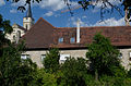
Holy Blood Catholic pilgrimage church | Tower choir and chapel to the north, mid-15th century, nave 1605–1615; With | D-6-75-139-28 |
 more pictures |
| Kanalgasse 6 ( location ) |
Residential building | Two-storey mansard half-hipped roof, partly plastered half-timbering, 18th century | D-6-75-139-225 |
 more pictures
|
| Kirchgasse 12 ( location ) |
Residential building | Two-storey eaves gable roof building with plastered half-timbered upper storey, essentially 18th century, rebuilt in 1939 and 1956 | D-6-75-139-35 | |
| Kirchgasse 15 ( location ) |
Residential stable house | Two-storey saddle roof building with half-timbered upper storey, the core of the 18th century | D-6-75-139-37 |
 more pictures |
| Kirchgasse 20 ( location ) |
Residential building | Two-storey, gable-roof construction, plastered half-timbering, 18th century | D-6-75-139-39 |
 more pictures |
| Kirchgasse 24 ( location ) |
Residential building | Two-storey, gable-roof construction, plastered half-timbering, 18th century | D-6-75-139-41 |
 more pictures |
| Kirchgasse 25 ( location ) |
Residential building | Two-storey, gable-independent saddle roof building with plastered half-timbered upper storey, 18th century | D-6-75-139-42 |
 more pictures |
| Kirchgasse 27 ( location ) |
Residential building | Two-storey eaves half-hipped roof building with plastered half-timbered upper storey and round arched gate passage, marked "1721" | D-6-75-139-44 |
 more pictures |
| Kirchgasse 28 ( location ) |
Gabled house | With plastered half-timbered gable and tailcoat roof, 18./19. century | D-6-75-139-45 |
 more pictures |
| Kirchgasse 29 ( location ) |
Gabled house | Two-storey saddle roof building with plastered half-timbered gable and arched gate passage, 18th century | D-6-75-139-46 |
 more pictures |
| Kirchgasse 30 ( location ) |
Former winery | Two-storey hipped roof building with plastered half-timbered upper storey and arched basement exit, early 18th century, changed around 1795 | D-6-75-139-47 |
 more pictures |
| Kirchgasse 30 ( location ) |
Former winery | Courtyard gate with Madonna figure, inscribed "1797" | D-6-75-139-47 | |
| Kirchgasse 32 ( location ) |
Wenkheimer Hof | Two-storey steep saddle roof building with a gates, built in 1570 as the residence and official residence of the Oberamtmann von Wenkheim, marked “1570” on the Wappenstein, later changed | D-6-75-139-48 |
 more pictures |
| Kirchplatz 5 ( location ) |
House figure | Saint Sebastian, wood, painted, 17th century | D-6-75-139-51 | |
| Kirchplatz 7 ( location ) |
Vinotheque | Two-storey saddle roof construction on a hook-shaped floor plan, plastered framework, partly drilled window and door frames, labeled "1724" and "1784" | D-6-75-139-226 |
 more pictures |
| Kirchplatz 8 ( location ) |
Catholic parish church of St. Vitus | Late Gothic hall church, choir and tower basement first half of the 15th century, nave and tower upper storeys completed in 1612 | D-6-75-139-52 |
 more pictures |
| Kirchplatz 8 ( location ) |
Crucifixion group | 19th century | D-6-75-139-52 |
 more pictures |
| Kronsberg, on the eastern outskirts, near the pond ( location ) |
Wayside shrine | On a simple base a square column, tapering at the top, a curved top with the coronation of Mary, second half of the 18th century | D-6-75-139-145 | |
| Lange Gasse 1 ( location ) |
Residential and guest house | Two-storey, gable-independent gable roof building in a corner position, plastered half-timbered upper storey, 17th century | D-6-75-139-54 |
 more pictures |
| Lange Gasse 1 ( location ) |
Madonna figure | 19th century | D-6-75-139-54 |
 more pictures |
| Lange Gasse 2 ( location ) |
Residential building | Three-storey eaves building with hipped roof with a round arched passage, marked "1603" | D-6-75-139-55 |
 more pictures |
| Lange Gasse 3 ( location ) |
Half hipped roof house | Sandstone cuboid, around 1800 | D-6-75-139-56 | |
| Lange Gasse 5 ( location ) |
Residential building | Two-storey gable-independent gable roof building with half-timbered upper storey, 17th century | D-6-75-139-57 |
 more pictures |
| Lange Gasse 5 ( location ) |
Madonna figure | 18th century | D-6-75-139-57 |
 more pictures |
| Lange Gasse 5 ( location ) |
Anthony figure | 18th century | D-6-75-139-57 |
 more pictures |
| Lange Gasse 6 ( location ) |
Residential building | Two-story hipped roof building with a plastered half-timbered upper floor, in a corner position, 18th century | D-6-75-139-58 |
 more pictures |
| Lange Gasse 7 ( location ) |
Residential building | Two- and three-storey eaves-sided saddle roof construction with ornamental half-timbered upper storeys, first half of the 18th century | D-6-75-139-59 |
 more pictures |
| Lange Gasse 9 ( location ) |
Residential building | Three-storey eaves gable roof building with protruding half-timbered upper storeys and arched portal, marked "1652" | D-6-75-139-60 |
 more pictures |
| Lange Gasse 10 ( location ) |
Eaves side house with stepped gables | Upper floor plastered half-timbering, 17th century; Archway, marked "1804" | D-6-75-139-61 |
 more pictures |
| Lange Gasse 12 ( location ) |
Residential building | Two-storey eaves gable roof building with half-timbered upper storey, 17th / 18th centuries century | D-6-75-139-62 |
 more pictures |
| Lange Gasse 14 ( location ) |
Eaves side house | With plastered half-timbered upper storey and arched gate passage, end of the 17th century | D-6-75-139-63 |
 more pictures |
| Lange Gasse 14 ( location ) |
Nepomuk figure | 18th century | D-6-75-139-63 |
 more pictures |
| Lange Gasse 15 ( location ) |
Eaves side house | Two-storey saddle roof building with gate passage, half-timbered, 1612 | D-6-75-139-64 |
 more pictures |
| Lange Gasse 15 ( location ) |
Courtyard gate | Massive, marked "1624" | D-6-75-139-64 |
 more pictures |
| Lange Gasse 16 ( location ) |
Residential building | Two-storey eaves gable roof building with half-timbered upper storey, drilled entrance portal with skylight, 17th / 18th centuries century | D-6-75-139-65 |
 more pictures |
| Lange Gasse 17 ( location ) |
Residential and commercial building | Two-storey eaves hipped roof building with half-timbered upper storey, courtyard gate marked "1624" | D-6-75-139-66 |
 more pictures |
| Lange Gasse 18 ( location ) |
Double gabled house | With half-timbered gables of the 16./17. Century, drilled window frames and ogival gate entrance | D-6-75-139-67 |
 more pictures |
| Lange Gasse 20 ( location ) |
Residential building | Two-storey half-hipped roof building in a corner, first half of the 19th century | D-6-75-139-68 |
 more pictures |
| Lange Gasse 23 ( location ) |
Residential building | Two-storey eaves saddle roof building with facade structure in the neo-renaissance style, around 1870/80 | D-6-75-139-69 |
 more pictures |
| Lange Gasse 28 ( location ) |
Residential building | Former guest house Zum Goldenen Lamm, wide eaves gable roof building with round arched gate passage, half-timbered upper floor, marked "1616" | D-6-75-139-70 |
 more pictures |
| Lange Gasse 29 ( location ) |
Residential and guest house | Two-storey eaves half-hipped roof building with plastered half-timbered upper storey and drilled frames, 18th century | D-6-75-139-71 |
 more pictures |
| Lange Gasse 34 ( location ) |
Residential building | Two-storey eaves gable roof building with plastered half-timbered upper storey, 18th century, courtyard wall gate with coat of arms to Schäfereigasse, inscribed "1700" | D-6-75-139-72 |
 more pictures |
| Lange Gasse 36 ( location ) |
Residential house, former Ilmbacher Hof | Two-storey eaves saddle roof building with drilled window frames and arched gate passage, 18th century | D-6-75-139-74 |
 more pictures |
| Ludwigstrasse ( location ) |
So-called Johann Nepomuk Bridge | Arched bridge made of sandstone blocks over the former inner city moat, 18th century | D-6-75-139-85 | |
| Ludwigstrasse 2 ( location ) |
Residential stable house | Two-storey gable-independent half-hipped roof building with plastered half-timbered upper storey, around 1800 | D-6-75-139-75 |
 more pictures |
| Ludwigstrasse 3 ( location ) |
Residential building | Two-story hipped roof building with plastered half-timbered upper floor, profiled eaves cornice, 18th / 19th centuries Century; House figure, Vesper picture by Dettelbach, inscribed "1725" | D-6-75-139-76 |
 more pictures |
| Ludwigstrasse 6 ( location ) |
Residential building | Wide eaves side building with plastered half-timbered upper floor, 17th century; Pietà, 17./18. century | D-6-75-139-77 | |
| Ludwigstrasse 10 ( location ) |
Inn | Two-storey eaves gable roof building with half-timbered upper storey, corner location, 18th century | D-6-75-139-78 |
 more pictures |
| Ludwigstrasse 14 ( location ) |
Former Domkapitelsche winery | Two-storey, gable-independent steep saddle roof construction, partly with drilled window frames, 17th / 18th centuries century | D-6-75-139-79 |
 more pictures |
| Ludwigstrasse 14 ( location ) |
Quarry stone barn | With a half-hipped roof, 18th century | D-6-75-139-79 |
 more pictures |
| Ludwigstrasse 14 ( location ) |
Outbuildings | Second half of the 19th century | D-6-75-139-79 | |
| Ludwigstrasse 14 ( location ) |
Courtyard gate | Inscribed "1728" | D-6-75-139-79 |
 more pictures |
| Ludwigstrasse 15 ( location ) |
Former Gasthaus zur Schwane | Two-storey eaves hipped roof building with half-timbered upper storey and drilled window frames, early 18th century, cantilever, 18th / 19th century century | D-6-75-139-80 |
 more pictures |
| Ludwigstrasse 16 ( location ) |
winery | Eaves side house with hipped gable roof to the west, inscribed "1708" and "1712" | D-6-75-139-81 |
 more pictures |
| Ludwigstrasse 16 ( location ) |
winery | Storage building with half-timbering | D-6-75-139-81 |
 more pictures |
| Ludwigstrasse 20 ( location ) |
Residential building | Two-storey eaves gable roof building with drilled window and door frames, first half of the 18th century | D-6-75-139-82 |
 more pictures |
| Ludwigstrasse 21 ( location ) |
Residential building | Two-storey eaves gable roof construction in corner position, with plastered half-timbered upper storey, inscribed "1714" | D-6-75-139-83 |
 more pictures |
| Ludwigstrasse 21 ( location ) |
Madonna figure | 18th century | D-6-75-139-83 | |
| Ludwigstrasse 22 ( location ) |
Residential building | Two-storey half-hipped roof building with plastered half-timbered upper storey, 17th / 18th centuries century | D-6-75-139-84 |
 more pictures |
| Ludwigstrasse 22 ( location ) |
Arched Gate | 17th century | D-6-75-139-84 |
 more pictures |
| Marketplace ( location ) |
Market fountain | Octagonal fountain basin made of shell limestone, fountain figure, Immaculata (copy, original in town hall), inscribed "1790" | D-6-75-139-100 |
 more pictures |
| Marketplace 1 ( location ) |
town hall | Three-storey hipped roof building with corner pilasters and central projections with a dwelling, outside staircase and portal gable with segmented arch, by Joseph Greising , 1716–1718 | D-6-75-139-87 |
 more pictures |
| Marktplatz 6 ( location ) |
House figure | Madonna and Child, 18th century | D-6-75-139-88 |
 more pictures |
| Marketplace 7 ( location ) |
Residential and commercial building | Two-storey eaves side house, in the core 17th / 18th century | D-6-75-139-89 |
 more pictures |
| Marktplatz 8 ( location ) |
Residential and commercial building | Two-storey eaves side building with gable roof, in the core 17th / 18th centuries century | D-6-75-139-90 |
 more pictures |
| Marktplatz 8 ( location ) |
Madonna figure | 19th century | D-6-75-139-90 |
 more pictures |
| Marketplace 10 ( location ) |
Residential building | Two-storey gable-independent hipped roof building with half-timbering, first half of the 18th century | D-6-75-139-92 | |
| Marktplatz 16 ( location ) |
Residential building | Two-storey saddle roof building with plastered, half-timbered upper storey, 17th / 18th centuries Century, carved rococo portal with rocaille pilasters, around 1760 | D-6-75-139-93 |
 more pictures |
| Marktplatz 16 ( location ) |
Vesper picture | Wooden, on wooden console with putti head, 17th century | D-6-75-139-93 |
 more pictures |
| Marktplatz 19 ( location ) |
Former post office, now a winery | Broadly supported two-storey gable half-hipped mansard roof, 18th century | D-6-75-139-94 |
 more pictures |
| Marktplatz 21 ( location ) |
Former Goldenes Kreuz inn | Two-storey hipped roof building with half-timbered upper storey and drilled window frames, core 1496 (dendrochronologically dated), facade 1812 | D-6-75-139-95 |
 more pictures |
| Marktplatz 22 ( location ) |
Former Gasthof Zur Goldenen Sonne, today a savings bank | Two-storey eaves gable roof building with ornamental half-timbered upper storey, 17th / 18th centuries century | D-6-75-139-96 |
 more pictures |
| Marktplatz 23 ( location ) |
Residential and commercial building | Two-storey eaves gable roof construction, Renaissance triforium on the upper floor, early 17th century | D-6-75-139-97 |
 more pictures |
| Marktplatz 25 ( location ) |
Residential building | Two-storey eaves gable roof building with one-sided half hipped and half-timbered upper storey, second half of the 18th century | D-6-75-139-98 |
 more pictures |
| Marketplace 26; Marketplace 27; Marktplatz 28 ( location ) |
Former school house | Two-storey sandstone cuboid structure on a hook-shaped floor plan, with a hipped roof and central projectile, 1878 | D-6-75-139-99 |
 more pictures |
| on the way to the ruins of Speckfeld ( ) |
Torture | With cross relief, inscribed "1867"
not re-qualified, not mapped in the Bavarian Monument Atlas |
D-6-75-139-155 | |
| Maxstrasse 1 ( location ) |
Residential building | Two-storey eaves side building with a hipped gable roof on one side and a round arched gate entrance, limestone with sandstone structures, first half of the 19th century | D-6-75-139-101 |
 more pictures |
| Maxstrasse 3 ( location ) |
Residential building | Two-storey eaves side house with gate passage, marked "1705", rebuilt at the beginning of the 19th century | D-6-75-139-102 |
 more pictures |
| Maxstrasse 6 ( location ) |
Residential building | Two-storey eaves saddle roof building with plastered half-timbered upper storey, 18th century | D-6-75-139-104 |
 more pictures |
| Maxstrasse 21 ( location ) |
Residential building | Two-storey hipped roof building with ornamental half-timbered upper storey, lengthways rectangular extension, in corner position, 17th / 18th century. century | D-6-75-139-107 |
 more pictures |
| Maxstrasse 22 ( location ) |
Gasthof Goldener Stern | Two-storey semi-hipped mansard roof with a plastered half-timbered upper storey, 18th century | D-6-75-139-108 |
 more pictures |
| Maxstraße 22, on the garden wall ( location ) |
Nepomuk figure | 18th century | D-6-75-139-108 |
 more pictures |
| Maxstrasse 23 ( location ) |
Residential building | Two-storey gable roof building with plastered half-timbering, 18th century | D-6-75-139-109 |
 more pictures |
| Maxstrasse 24 ( location ) |
Residential building | Two-storey gable roof building with eaves, marked "1822" | D-6-75-139-110 |
 more pictures |
| Maxstrasse 24 ( location ) |
Immaculata | 18th century | D-6-75-139-110 |
 more pictures |
| Maxstrasse 26 ( location ) |
Inn | Two-storey hipped roof building with half-timbered upper storey, round-arched gate passage, drilled frames, 17th century | D-6-75-139-111 |
 more pictures |
| Maxstrasse 26 ( location ) |
boom | 18th century | D-6-75-139-111 | |
| Maxstrasse 27 ( location ) |
Residential and commercial building | Two-storey gable-independent half-hipped roof building with half-timbered upper storey, 17th century | D-6-75-139-112 |
 more pictures |
| Maxstrasse 28 ( location ) |
Former Würzburg official court | Two-storey sandstone cuboid building with hipped roof, inscribed "1693", Amthof des Amtes Iphofen | D-6-75-139-113 |
 more pictures |
| Stöhrsgasse 6 ( location ) |
Former Würzburg official court | Longitudinal rectangular extension in Stöhrsgasse | D-6-75-139-113 | |
| Mittelgasse 4 ( location ) |
Residential stable house | Two-storey, gable-independent saddle roof building with half-timbered upper storey, 18th century | D-6-75-139-114 |
 more pictures |
| Mittlere Gräbengasse 3 ( location ) |
Farmhouse | Two-storey gable-independent saddle roof building with plastered half-timbered upper storey, 18th / 19th centuries century | D-6-75-139-115 | |
| Mittlere Gräbengasse 5 ( location ) |
Farmhouse | Two-storey gable-independent saddle roof building with plastered half-timbered upper storey, 18th / 19th centuries century | D-6-75-139-116 | |
| Mittlere Gräbengasse 5 ( location ) |
Madonna figure | 19th century | D-6-75-139-116 | |
| Near Aegidiengasse; Near Aegidienstraße; Aegidiengasse 3; Agidiengasse 4 ( location ) |
Former Aegidien- or Ilgenhof | Two-storey half-hipped roof building with drilled window and door frames, owned by the St. Egidien Monastery in Nuremberg from 1465, transferred to the Bamberg Monastery in 1538, first half of the 18th century using components from the 15th and 16th centuries. Century, partially modernized | D-6-75-139-4 |
 more pictures |
| Near Aegidiengasse; Near Aegidienstraße; Aegidiengasse 3; Agidiengasse 4 ( location ) |
Former Aegidien- or Ilgenhof | Round arch | D-6-75-139-4 |
 more pictures |
| Near church square ( location ) |
Catholic cemetery chapel St. Michael | Two-storey building of 1412 m ossuary in the basement | D-6-75-139-53 |
 more pictures |
| Neudeck, on the road to Birklingen ( location ) |
crucifix | Wooden cross with a baroque body of Christ, 1941 | D-6-75-139-154 | |
| Obere Gasse 8 ( location ) |
Residential building | Single-storey gabled house with half-timbered gable, 17th / 18th centuries Century, barn with half-hipped roof and half-timbered gable, 18th century | D-6-75-139-118 |
 more pictures |
| Obere Gasse 12 ( location ) |
Residential building | Single-storey eaves building with hipped roof, twin windows with drilled frames and basement exit on the street-side facade, inscribed "1748" | D-6-75-139-119 |
 more pictures |
| Obere Gasse 13 ( location ) |
Gabled house | Half-timbered gable, 1602. Stone miraculous image based on the Dettelbacher model in a niche on the upper floor | D-6-75-139-120 |
 more pictures |
| Obere Gasse 14 ( location ) |
Residential building | Eaves side building with plastered half-timbered upper floor, round arched gate passage marked “1706”; modernized | D-6-75-139-121 |
 more pictures |
| Obere Gasse 15 ( location ) |
Residential building | Two-storey gable-independent saddle roof building with plastered half-timbered upper storey, 17th / 18th centuries century | D-6-75-139-122 |
 more pictures |
| Obere Gasse 15 ( location ) |
House figure | Madonna and Child, colored wood, 17th / 18th century century | D-6-75-139-122 | |
| Obere Gräbengasse 2 ( location ) |
Kastenhof, residential building | Two-storey eaves hipped roof building with plastered half-timbered upper storey, arched gate passage and drilled window frames, built for the Ebrachschen Kastner (treasurer) Georg Kaspar Linck in 1712 | D-6-75-139-123 |
 more pictures |
| Obere Gräbengasse 2 ( location ) |
portal | With Nepomuk figure, 18th century | D-6-75-139-123 |
 more pictures |
| Obere Gräbengasse 6 ( location ) |
Residential building | Two-storey, gable-independent saddle roof building with half-timbered upper storey, clad, 18th century | D-6-75-139-124 | |
| Obere Gräbengasse 9 ( location ) |
Winery | Two-storey hipped roof building with half-timbered upper storey, labeled "1812" | D-6-75-139-125 |
 more pictures |
| Obere Gräbengasse 9 ( location ) |
Winery, half-timbered barn | With half-hipped roof, 18./19. century | D-6-75-139-125 |
 more pictures |
| Obere Gräbengasse 9 ( location ) |
Wayside shrine | With holy blood, 18th century | D-6-75-139-125 |
 more pictures |
| Obere Gräbengasse 10 ( location ) |
Farmhouse | Two-storey hipped roof building with plastered half-timbered upper storey, 18th / 19th centuries century | D-6-75-139-126 |
 more pictures |
| Obere Gräbengasse 10 ( location ) |
Pietà | 18./19. century | D-6-75-139-126 |
 more pictures |
| Pfarrgasse 3 ( location ) |
Weingut of the Würzburg Juliusspital | Two-storey mansard roof with drilled window and door frames, double flight of stairs, Immacilata, 1724–26 | D-6-75-139-129 |
 more pictures |
| Pfarrgasse 4 ( location ) |
Residential building | Two-storey eaves saddle roof building with plastered half-timbered upper storey, 18th / 19th centuries century | D-6-75-139-130 |
 more pictures |
| Pfarrgasse 6 ( location ) |
Residential building | Two-storey eaves saddle roof building in corner position with plastered half-timbered upper storey, marked "1778" | D-6-75-139-131 |
 more pictures |
| Pfarrgasse 12 ( location ) |
Rectory | Two-story house with a hooked floor plan with half-timbered upper floor and mansard roof, 1732 | D-6-75-139-133 |
 more pictures |
| Pfarrgasse 12 ( location ) |
Wooden figure of Mary with child and scepter | Above the door on a plinth, sheet metal canopy, early 18th century | D-6-75-139-133 |
 more pictures |
| Pfarrgasse 12 ( location ) |
Half-timbered barn | 1730 | D-6-75-139-133 | |
| Pfarrgasse 13 ( location ) |
Gate construction | Two-storey eaves-sided saddle roof building with half-timbered upper storey and ogival passage, 14th and 18th centuries | D-6-75-139-134 |
 more pictures |
| Pfarrgasse 22 ( location ) |
Residential building | Two-storey hipped roof building with plastered half-timbered upper storey, 18th century | D-6-75-139-227 |
 more pictures |
| on the old road to Rödelsee ( ) |
Stone cross | Late medieval
not re-qualified, not mapped in the Bavarian Monument Atlas |
D-6-75-139-152 | |
| Stöhrsgasse 1 ( location ) |
Benefit house | Two-storey saddle roof building with half-timbered upper storey, 17th / 18th centuries century | D-6-75-139-136 |
 more pictures |
| Stöhrsgasse 1 ( location ) |
Half-timbered barn | 17./18. century | D-6-75-139-136 | |
| Stöhrsgasse 1 ( location ) |
Outbuildings | One storey, 17./18. century | D-6-75-139-136 |
 more pictures |
| Stöhrsgasse 1 ( location ) |
Enclosing wall | Denotes "175?" | D-6-75-139-136 |
 more pictures |
| Untere Gräbengasse 15 ( location ) |
Farmhouse | Two-storey gable-independent saddle roof building with plastered half-timbered upper storey, 18th / 19th centuries century | D-6-75-139-140 |
 more pictures |
| Untere Gräbengasse 15 ( location ) |
Madonna figure | 19th century | D-6-75-139-140 |
 more pictures |
Birklingen
| location | object | description | File no. | image |
|---|---|---|---|---|
| Badger's bones; on the road to Birklingen ( location ) |
Trinity Chapel | simple building with a gable roof sloping to the south and ridge turrets, 1715; with equipment | D-6-75-139-142 | |
| Iphöfer Straße 8 ( location ) |
Farm building of the former Augustinian monastery | preserved in parts, 16th century | D-6-75-139-157 | |
| Iphöfer Straße 8 ( location ) |
barn | Sandstone block building with a gable roof and roller door, 17th century | D-6-75-139-157 | |
| Klostergasse 3 ( location ) |
Catholic branch church St. Maria | former Augustinian canons' collegiate church, choir closed on three sides and tower ajar to the north 1458–1463, originally Building rebuilt according to plans by Johann Michael Fischer , nave 1789, west facade 1789/94; With | D-6-75-139-156 |
 more pictures |
| Klostergasse 8 ( location ) |
Former convent building of the Augustinian canons | Part of the foundations preserved in the middle of the 15th century | D-6-75-139-158 |
Bruckhof
| location | object | description | File no. | image |
|---|---|---|---|---|
| Bruckhof 2; Bruckhof 1 ( location ) |
grange | Residential stable house, two-storey hipped roof building with plastered half-timbered upper floor, 17th / 18th centuries century | D-6-75-139-159 | |
| Bruckhof 2; Bruckhof 1 ( location ) |
grange | Half-timbered barn with half-hipped roof, 17th / 18th centuries century | D-6-75-139-159 |
Domherrnmühle
| location | object | description | File no. | image |
|---|---|---|---|---|
| Domherrnmühle 1; Near Domherrnmühle ( location ) |
Domherrnmühle | Residential house, two-storey mansard roof building with extension, 18th / 19th centuries century | D-6-75-139-160 |
 more pictures |
| Domherrnmühle 1; Near Domherrnmühle ( location ) |
Domherrnmühle | Barns and farm buildings | D-6-75-139-160 |

|
Dornheim
| location | object | description | File no. | image |
|---|---|---|---|---|
| Altmannshäuser Straße 5 ( location ) |
Catholic parish church of St. Laurentius | Hall building with facade tower, 1793, renovated after 1945; With | D-6-75-139-161 |
 more pictures |
| Altmannshäuser Straße 15 ( location ) |
Residential stable house | single-storey gable-independent gable roof building with half-timbered gable, in the core 18th century, marked 1845, renewed after 1945 | D-6-75-139-163 |
 more pictures |
| Altmannshäuser Straße 16 ( location ) |
Evangelical Lutheran branch church | simple hall with retracted choir, neo-Gothic, 1858; With | D-6-75-139-162 |
 more pictures |
| Altmannshäuser Straße 17 ( location ) |
Residential building | two-storey sandstone block building with gable roof, 1889 | D-6-75-139-164 |
 more pictures |
| Altmannshäuser Straße 21 ( location ) |
Former inn | Two-storey eaves hipped roof building with round arched gate passage, in the core in the middle of the 17th century, externally remodeled in 1926 | D-6-75-139-165 |
 more pictures |
| Altmannshäuser Straße 22 ( location ) |
Farmhouse | single-storey gable roof building, half-timbered, marked 1786. | D-6-75-139-166 |
 more pictures |
| Altmannshäuser Straße 27 ( location ) |
Inscription stone | denotes 1847; not re-qualified | D-6-75-139-167 |
 more pictures |
| Altmannshäuser Straße 31 ( location ) |
House relief with coat of arms | designated 1856; not re-qualified | D-6-75-139-168 |
 more pictures |
| on the road to Hellmitzheim ( location ) |
Wayside shrine | with relief of St. Georg, marked 1963; not re-qualified | D-6-75-139-232 |
 more pictures |
| Dorfstrasse 26 ( location ) |
Residential stable house | single-storey gable-roof construction, half-timbered, 2nd half of the 18th century | D-6-75-139-169 |
 more pictures |
| Guldenberg; on the road to Nenzenheim ( location ) |
Wayside shrine | with crucifixion, base with depiction of a handkerchief, renewed in 1957 | D-6-75-139-170 |
 more pictures |
Forester's house
| location | object | description | File no. | image |
|---|---|---|---|---|
| Forsthaus 1 ( location ) |
Forester's house | single-storey half-timbered house with half-hipped roof, around 1800 | D-6-75-139-234 |
Hellmitzheim
| location | object | description | File no. | image |
|---|---|---|---|---|
| Helmboldstrasse 3 ( location ) |
Residential stable house | Two-storey gable-independent half-hipped roof building with half-timbered upper storey, 1st half of the 19th century | D-6-75-139-172 | |
| Helmboldstrasse 4 ( location ) |
Former stable house | single-storey gable roof building with half-timbering, 17th century | D-6-75-139-173 | |
| Helmboldstrasse 18; Helmboldstrasse 20 ( location ) |
Residential stable house | one or two-storey fracked roof building, half-timbered, marked 1840, in the core probably 17th / 18th. century | D-6-75-139-175 | |
| Kirchbach ( location ) |
bridge | one-bay arched bridge, sandstone, 18th century; over the Kirchbach | D-6-75-139-228 | |
| Mönchsondheimer Straße 4 ( location ) |
Residential stable house | single-storey gable roof building with half-timbered gable, 17th century | D-6-75-139-176 |
 more pictures |
| Mönchsondheimer Straße 5 ( location ) |
Evangelical Lutheran Parish Church | Choir tower church, formerly within a fortified church, tower 15th century, nave 15th / 16th century. Century, new construction of the upper part of the tower and the nave using old components of the previous building destroyed in 1945 | D-6-75-139-171 |
 more pictures |
| Mönchsondheimer Straße 8 ( location ) |
Residential stable house | single-storey, gable-independent gable roof building with forehead and two-storey dwarf house extension, marked 1830, with ornamental framework from the 17th century, in the core 1591 (dendrochronologically dated) | D-6-75-139-177 |
 more pictures |
| Mönchsondheimer Straße 18 ( location ) |
Residential stable house | single-storey gable half-hipped mansard roof, half-timbered, marked 1822 | D-6-75-139-178 |
 more pictures |
| Mönchsondheimer Straße 23 ( location ) |
Residential stable house | single-storey steep saddle roof building with plastered half-timbered gable, around 1800 | D-6-75-139-179 | |
| Mönchsondheimer Straße 23 ( location ) |
Courtyard wall and gate pillars | inscribed 1789 | D-6-75-139-179 | |
| Mönchsondheimer Straße 23 ( location ) |
Well house with hood | 18th century | D-6-75-139-179 | |
| Sportplatzstrasse 5 ( location ) |
Residential building | Former hunter's house of the Counts von Rechteren-Limpurg-Speckfeld, two-storey plastered hipped roof building, upper floor with half-timbering, marked 1755 | D-6-75-139-250 |
Hohlbrunnermühle
| location | object | description | File no. | image |
|---|---|---|---|---|
| Hohlbrunnermühle 1 ( location ) |
Hohlbrunnermühle | two-storey half-hipped roof building, plastered half-timbering, 18th century | D-6-75-139-180 | |
| Hohlbrunnermühle 1 ( location ) |
Hohlbrunnermühle | Barns and wooden beds | D-6-75-139-180 |
Mönchsondheim
| location | object | description | File no. | image |
|---|---|---|---|---|
| At the Kirchenburg 15 ( location ) |
Small farmhouse | single-storey saddle roof building with half-timbered gable, 18th / 19th centuries Century, in the core 1579 (dendro.dat.) | D-6-75-139-237 | |
| At the Kirchenburg 15 ( location ) |
Dormitory extension | 1920 | D-6-75-139-237 | |
| Hauptstrasse 1; Near main street ( location ) |
Cemetery chapel | Hall building from 1722/23; With | D-6-75-139-183 |
 more pictures |
| Hauptstrasse 1; Near main street ( location ) |
graveyard | with gravestones from the 18th / 19th centuries Century | D-6-75-139-183 | |
| Hauptstrasse 11 ( location ) |
Cornerstone | Sandstone, marked 1832 | D-6-75-139-184 | |
| Hauptstrasse 18 ( location ) |
Former rectory | two-storey half-timbered building with saddle roof, gable with ornamental framework, 1701 | D-6-75-139-229 | |
| Hauptstrasse 19 ( location ) |
Residential stable house | Two-storey saddle roof building with a ground floor set back on one side, corner stone marked 1849 | D-6-75-139-185 |
 more pictures |
| Hauptstrasse 24 ( location ) |
Half-timbered house | single-storey saddle roof building on a high base, marked 170 (?) 3 (only the front part survived) | D-6-75-139-186 |
 more pictures |
| Near Iphöfer Straße ( location ) |
Former community barn | So-called sheep barn, half-timbered building on a sandstone base with a gable roof, 1927 | D-6-75-139-233 |
Parts of the fortified church museum
| location | object | description | File no. | image |
|---|---|---|---|---|
| At the fortified church 2 ( location ) |
Former town hall | two-storey eaves gable roof construction with half-timbering, 1557, underpinning of the ground floor in 1840 | D-6-75-139-187 |
 more pictures |
| At the fortified church 4 ( location ) |
Single-storey gabled house | Former grocer, plastered half-timbering, around 1690 | D-6-75-139-230 |

|
| At the Kirchenburg 5 ( location ) |
Former village school | two-storey hipped roof building, marked 1927 | D-6-75-139-238 |

|
| At the Kirchenburg 6 ( location ) |
Former inn "Schwarzer Adler" | Guest and residential building, two-storey eaves building with hipped roof with plastered half-timbering, marked 1790 | D-6-75-139-188 |

|
| At the Kirchenburg 6 ( location ) |
Former inn "Schwarzer Adler" | Public house sign | D-6-75-139-188 | |
| At the Kirchenburg 6 ( location ) |
Former inn "Schwarzer Adler" | Cattle barn, brick building with a gable roof, 1901 | D-6-75-139-188 | |
| At the Kirchenburg 6 ( location ) |
Former inn "Schwarzer Adler" | Remise, 1909 | D-6-75-139-188 | |
| At the Kirchenburg 6 ( location ) |
Former inn "Schwarzer Adler" | Bowling alley, 1909 | D-6-75-139-188 | |
| At the Kirchenburg 6 ( location ) |
Former inn "Schwarzer Adler" | Barn, 1819, extended in 1909 | D-6-75-139-188 | |
| At the Kirchenburg 6 ( location ) |
Former inn "Schwarzer Adler" | Machine shop, 1928 | D-6-75-139-188 | |
| At the Kirchenburg 6 ( location ) |
Former inn "Schwarzer Adler" | Courtyard house, 1720 | D-6-75-139-188 | |
| At the Kirchenburg 6 ( location ) |
Former inn "Schwarzer Adler" | Pigsties, 1906 | D-6-75-139-188 | |
| At the fortified church 7; At the fortified church 7a; At the fortified church 9a; Close to An der Kirchenburg ( location ) |
Fortified church | Gaden with basement and all half-timbered upper floors leaning against the circumferential wall built on an irregular square plan, in the core of the 15th century, following the construction of the church in the 17th / 18th century. Century largely renewed, upper floor of the northern Gaden reconstructed 1978/79; Gatehouse, marked 1698 | D-6-75-139-182 |
 more pictures |
| At the Kirchenburg 8 ( location ) |
Small farm | Stable house, single-storey saddle roof building, 1700 | D-6-75-139-189 | |
| At the Kirchenburg 8 ( location ) |
Small farm | Stable house, single-storey saddle roof building, 1700 | D-6-75-139-189 | |
| At the Kirchenburg 8 ( location ) |
Small farm | Pigsty, sandstone block with pent roof, 1822 | D-6-75-139-189 | |
| At the Kirchenburg 9 ( location ) |
Evangelical Lutheran Parish Church of St. Boniface | Choir tower church within a fortified church, 1688–1690; With | D-6-75-139-181 |
 more pictures |
| At the Kirchenburg 9a ( location ) |
Former sacristan's house | Used as a school until around 1900, two-storey saddle roof building with half-timbered upper floor, marked 1698 and 1837 | D-6-75-139-190 |
Mill (lower)
| location | object | description | File no. | image |
|---|---|---|---|---|
| Plank mill 1; Near Plankenmühle ( location ) |
Plank mill | Two-storey mansard half-hipped roof building with plastered quarry stone masonry and half-timbered gable, marked 1789 | D-6-75-139-191 | |
| Plank mill 1; Near Plankenmühle ( location ) |
Plank mill | Outbuilding, 18./19. century | D-6-75-139-191 |
Nenzenheim
| location | object | description | File no. | image |
|---|---|---|---|---|
| At the sports field 4; Breitbachstraße 24 ( ) |
Six earth cellars | at the northeast exit of the village, 19th century | D-6-75-139-209 | |
| At the sports field 4; Breitbachstraße 24 ( ) |
Five earth cellars | in the center of the village, on the north-western edge of the cemetery | D-6-75-139-209 | |
| Breitbachstrasse 5 ( location ) |
Farmhouse | two-storey saddle roof building with half-timbering, marked 1688 | D-6-75-139-197 | |
| Breitbachstrasse 6 ( location ) |
Lintel | Sandstone, marked 1821 | D-6-75-139-198 | |
| Breitbachstrasse 17 ( location ) |
Cornerstone | marked 1849 | D-6-75-139-199 | |
| over the Hirtenbach ( ) |
bridge | over the Hirtenbach, probably 1st half of the 19th century; not re-qualified | D-6-75-139-208 | |
| Friedhofstraße 3, south of the fortified church ( location ) |
graveyard | Gravestones of the 18th / 19th centuries Century | D-6-75-139-194 |
 more pictures |
| Friedhofstrasse 5 ( location ) |
Rectory | two-storey eaves half-hipped roof building with a cornice, marked 1817 | D-6-75-139-195 |
 more pictures |
| Friedhofstrasse 10 ( location ) |
Residential stable house | single-storey saddle roof construction, half-timbered, marked 1842 | D-6-75-139-196 | |
| Krassolzheimer Straße 11 ( location ) |
Former Hutten Castle | now a farmhouse, two-storey saddle roof construction, marked 1852 | D-6-75-139-200 | |
| Krassolzheimer Straße 11 ( location ) |
Courtyard gate pillars | associated | D-6-75-139-200 | |
| Krassolzheimer Straße 12 ( location ) |
Residential stable house | Single storey, half-timbered gable, 1st half of the 19th century | D-6-75-139-201 | |
| Krassolzheimer Straße 22 ( location ) |
town hall | Two-storey saddle roof building with half-timbered upper storey above a high basement basement storey, on the northwest corner of the fortified church, marked 1544, changed in 1697, renovated in 1910 | D-6-75-139-202 | |
| Krassolzheimer Strasse 22a; Near Krassolzheimer Straße ( location ) |
Fortified church | almost rectangular complex from late medieval times | D-6-75-139-193 |
 more pictures |
| Krassolzheimer Strasse 22a; Near Krassolzheimer Straße ( location ) |
Fortified church | Gaden with half-timbered upper storeys, 18./19. century | D-6-75-139-193 | |
| Krassolzheimer Straße 24 ( location ) |
Evangelical Lutheran Parish Church | Hall building from 1910, tower basements late medieval, rebuilt after war destruction in 1946; With
Equipment ; within the late medieval fortified church |
D-6-75-139-192 |
 more pictures |
| Krassolzheimer Straße 27 ( location ) |
cornerstone | Sandstone, marked 1855 | D-6-75-139-203 | |
| Krassolzheimer Straße 31 ( location ) |
Cornerstone | Sandstone, marked 1833 | D-6-75-139-204 | |
| Schulzengasse 1 ( location ) |
cornerstone | Sandstone, marked 1860 | D-6-75-139-205 | |
| Schulzengasse 5 ( location ) |
cornerstone | Sandstone, marked 1853 | D-6-75-139-206 | |
| Untere Bergstrasse 8 ( location ) |
Cornerstone | marked 1860 | D-6-75-139-207 |
Kidney grinder
| location | object | description | File no. | image |
|---|---|---|---|---|
| Kidney mill 51 ( location ) |
Kidney grinder | two-storey sandstone block building with a crooked hip roof, marked 1855; Farm building with plastered half-timbering, the core of the 18th century | D-6-75-139-210 |
Possenheim
| location | object | description | File no. | image |
|---|---|---|---|---|
| Kirchstrasse 3 ( location ) |
Residential stable house | two-story hipped roof building with half-timbered upper floor, 1815 | D-6-75-139-214 | |
| Kirchstrasse 4 ( location ) |
Courtyard | Residential house, two-storey gable-independent hip roof building, marked 1789/1954; Barn and stable building, 18th century; Moving house, 18th century; Courtyard gate posts | D-6-75-139-215 | |
| Kirchstrasse 5 ( location ) |
Former fortified church | single-storey saddle roof building with cellar exit, 15./16. Century; Small remains of the former fortified church have been preserved | D-6-75-139-212 | |
| Kirchstrasse 7 ( location ) |
Former school | now a residential building, two-story hipped roof building with plastered half-timbered upper floor, marked 1827 | D-6-75-139-216 | |
| Kirchstrasse 9 ( location ) |
Evangelical Lutheran branch church | Hall building with facade tower and retracted choir closed on three sides, by Joseph Albert 1781–1784; With | D-6-75-139-211 |
 more pictures |
| Kirchstrasse 14 ( location ) |
Residential stable house | single-storey saddle roof construction with plastered half-timbered gable, 1789 | D-6-75-139-217 | |
| Near Kirchstrasse ( location ) |
graveyard | Cemetery with tombs from the 19th century, laid out in 1781; Sandstone cemetery wall, north gate and morgue 1848 | D-6-75-139-213 | |
| Poststrasse 1 ( location ) |
Inn | Two-storey two-wing hipped roof building with a hooked floor plan with a round arched gate entrance, 1783 | D-6-75-139-218 | |
| Poststrasse 2; Kirchstrasse ( location ) |
Former post office | now residential building, two-storey hipped roof building, in the core 17th / 18th Century, facade with Art Nouveau decorations 1832 | D-6-75-139-219 |

|
| Poststrasse 2; Kirchstrasse ( location ) |
barn | massive half-hipped roof with corner blocks, 2nd half of the 19th century | D-6-75-139-219 | |
| Poststrasse 2; Kirchstrasse ( location ) |
two stone benches | D-6-75-139-219 | ||
| Poststrasse 2; Kirchstrasse ( location ) |
old signpost | 19th century in front of the house | D-6-75-139-219 | |
| Poststrasse 7 ( location ) |
Residential building | between 1875 and 1972 town hall of the municipality of Possenheim, two-storey hipped roof building with bat dormers and plastered half-timbered upper floor, around 1800 | D-6-75-139-220 | |
| Poststrasse 12 ( location ) |
Residential stable house | single-storey gable roof building with half-timbered gable, marked 1857, in the core probably 18th century | D-6-75-139-221 | |
| Schulstrasse 1 ( location ) |
Residential stable house | single-storey saddle roof building with plastered half-timbered gable, marked 1853 | D-6-75-139-222 | |
| Schulstrasse 11 ( location ) |
Former residence and guest house | two-storey eaves gable roof construction, half-timbered house, around 1700 | D-6-75-139-231 |

|
Waldhof
| location | object | description | File no. | image |
|---|---|---|---|---|
| Waldhof 3 ( location ) |
grange | Farmhouse, two-story saddle roof building with half-timbered upper floor, 1809 | D-6-75-139-224 | |
| Waldhof 3 ( location ) |
grange | Half-timbered barn, marked 1809 | D-6-75-139-224 | |
| Waldhof 3 ( location ) |
grange | Sheepfold, marked 1853 | D-6-75-139-224 |
Former architectural monuments
This section lists objects that were previously entered in the list of monuments.
| location | object | description | File no. | image |
|---|---|---|---|---|
| Iphofen Marktplatz 9 ( location ) |
Residential building | Two-storey eaves saddle roof building with plastered half-timbered upper storey, 18th century | D-6-75-139-91 |
 more pictures |
Lost monuments
This section lists objects that were previously entered in the list of monuments, but no longer exist.
| location | object | description | File no. | image |
|---|---|---|---|---|
| Iphofen Kirchplatz 3 ( location ) |
Residential building | single-storey half-hipped roof building with half-timbered gable and arched cellar exit on the street side, labeled "1814" | D-6-75-139-50 |
See also
Remarks
- ↑ This list may not correspond to the current status of the official list of monuments. The latter can be viewed on the Internet as a PDF using the link given under web links and is also mapped in the Bavarian Monument Atlas . Even these representations, although they are updated daily by the Bavarian State Office for Monument Preservation , do not always and everywhere reflect the current status. Therefore, the presence or absence of an object in this list or in the Bavarian Monument Atlas does not guarantee that it is currently a registered monument or not. The Bavarian List of Monuments is also an information directory. The property of a monument - and thus the legal protection - is defined in Art. 1 of the Bavarian Monument Protection Act (BayDSchG) and does not depend on the mapping in the Monument Atlas and the entry in the Bavarian Monument List. Objects that are not listed in the Bavarian Monument List can also be monuments if they meet the criteria according to Art. 1 BayDSchG. Early involvement of the Bavarian State Office for Monument Preservation according to Art. 6 BayDSchG is therefore necessary in all projects.
literature
- Denis André Chevalley: Lower Franconia . Ed .: Michael Petzet , Bavarian State Office for the Preservation of Monuments (= Monuments in Bavaria . Volume VI ). Oldenbourg, Munich 1985, ISBN 3-486-52397-X .
Web links
- Bavarian Monument Atlas (cartographic representation of the Bavarian architectural and ground monuments by the BLfD , requires JavaScript)
- List of monuments for Iphofen (PDF) at the Bavarian State Office for Monument Preservation

Abtswind | Albertshofen | Biebelried | Buchbrunn | Castell | Dettelbach | Hostage wind | Großlangheim | Iphofen | Kitzingen | Kleinlangheim | Mainbernheim | Mainstockheim | Einersheim Market | Market wide | Marktsteft | Martinsheim | Nordheim am Main | Obernbreit | Prichsenstadt | Rödelsee | Rüdenhausen | Schwarzach am Main | Segnitz | Home of being | Sommerach | Sulzfeld am Main | Volkach | Wiesenbronn | Wiesentheid | Willanzheim