
List of architectural monuments in Dettelbach
The monuments of the Lower Franconian town of Dettelbach are compiled on this page . This table is a partial list of the list of architectural monuments in Bavaria . The basis is the Bavarian Monument List , which was first drawn up on the basis of the Bavarian Monument Protection Act of October 1, 1973 and has since been managed by the Bavarian State Office for Monument Preservation . The following information does not replace the legally binding information from the monument protection authority. This list reflects the update status from April 16, 2020 and contains 214 monuments.

Ensembles
Ensemble old town Dettelbach
Dettelbach ( location ) is located a little above the Main on the slope of the Bibergau mountains. The place mentioned for the first time in 741 has only slowly developed from a castle complex with an adjoining village into a larger settlement. The city elevation and the walling did not take place until 1484. Since the 16th century, Dettelbach gained increased importance through the pilgrimage to the miraculous image in the vineyard . The town is divided by the course of the Altbach. The eastern, older half of the city is grouped around the central castle hill, which protrudes to the south and west as a terrace and is supported by a lining wall. The parish church rises dominantly on top of it , while the location of the former castle is marked by what will later be the Rentamt, a building from the 18th century. At the foot of the retaining wall is the narrow market square on the site of the former castle village. Due to the hillside location, the roads in the eastern half of the city are mostly irregular and incline. The western half of the city, an extension of the 15th century, on the other hand, spreads out on flatter terrain and also has a more regular floor plan. In its center is the Spital, a foundation from 1481. A link between the two halves of the city is the late Gothic town hall built over the course of the Altbach , the ground floor hall of which serves as a bridge for the Würzburg - Bamberg thoroughfare . The town is primarily oriented towards agriculture and characterized by viticulture . Farms and winegrowers determine the townscape. Stately baroque courtyards dating from the 17th and 18th centuries line up their elongated eaves side fronts, each marked by a wide courtyard gate, along Würzburger and Bamberger Straße. The side streets are built with smaller courtyards, many of which, especially in the western half of the city, show the unplastered quarry stone houses typical of the landscape from the middle of the 19th century. Only the market square with a row of half-timbered houses slightly offset from one another is marked by trade. Boundary: city wall including the moat area. File number: E-6-75-117-1.
City fortifications Dettelbach
The fortification of Dettelbach took place after the city elevation in 1484 with wall, moat and towers. Two of the former five gates have survived, the Falter gate and the bridge gate. Most of the wall and towers are still standing. Addresses: Am Stadtgraben 2, 4, 6, Burggraben, Eichgasse 12, near Falterstraße, Fischergasse 9, 13, Hirtengasse 2, Langgasse 14, 20, 24, Eastern City Wall, Eastern City Wall 3, Südring, Südring 2, 4, 6, Westliche City wall. File number: D-6-75-117-3.
Starting in the northwest, clockwise, the following parts of the city fortifications have been preserved. The northern wall line between Alter Stadtgraben and Schweinfurter Strasse is mostly built into houses.
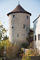
- Langgasse 24 ( location ): wall tower, round tower of the city fortifications, 15th century
- Langgasse 24, 22, 20 ( location ): city wall, 15th century, between the streets of Langgasse and Kühngasse
- Langgasse 20 ( location ): wall tower, remains of a round tower, 15th century
- Langgasse 18, 16, 14 ( location ): city wall, 15th century, between the streets of Langgasse and Kühngasse
- Langgasse 14 ( location ): wall tower, remains of a round tower, 15th century
- Langgasse 12 ( location ): city wall, 15th century, between the streets of Langgasse and Kühngasse
- Langgasse 10 ( location ): city wall, 15th century, between the streets of Langgasse and Kühngasse
- Langgasse 8 ( location ): city wall, 15th century, between the streets of Langgasse and Kühngasse
- Langgasse 6 ( location ): city wall, 15th century, between the streets of Langgasse and Kühngasse
- Langgasse 4 ( location ): City wall, 15th century, between the streets of Langgasse and Kühngasse with the remains of the foundations of a round tower
- Langgasse 2 ( location ): city wall, 15th century, between the streets of Langgasse and Kühngasse

Langgasse 24, wall tower
more pictures
Langgasse 24, wall tower
more pictures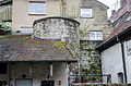
Langgasse 20, wall tower
more pictures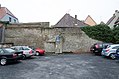
City wall at Langgasse 4
more pictures


No wall has been preserved between Schweinfurter Strasse and Brücker Tor.
| location | object | description | File no. | image |
|---|---|---|---|---|
| ( Location ) | Brücker Gate | City gate, two-storey gate tower with a gable roof, around 1500 | D-6-75-117-26 |
 more pictures |
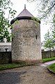
In the further course towards the east to the Faltertor, the preserved wall section begins at a wall tower and then runs closed between the wall towers to the Faltertor:
- Burggraben, north of Eichgasse 10 ( location ): wall tower, defense tower, 15./16. century
- Near moat 2 ( location ): wall tower, defense tower, 15./16. century
- Burggraben, north of Falterstraße 17 ( location ): wall tower, defense tower, 15./16. century
- Burggraben, north of Falterstraße 25 ( location ): wall tower, defense tower, 15./16. century
- Burggraben, north of Falterstraße 31 ( location ): wall tower, defense tower, 15./16. century
- Burggraben, northeast of Falterstraße 35 ( location ): wall tower, defense tower, 15th / 16th c. century

Wall tower at Eichgasse 10
more pictures
Wall tower near moat 2
more pictures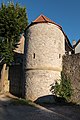
Wall tower north of Falterstraße 17, field side
more pictures
Wall tower north of Falterstraße 17, city side
more pictures
Wall tower north of Falterstraße 25, field side
more pictures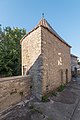
Wall tower north of Falterstraße 25, city side
more pictures
Wall tower north of Falterstraße 31, field side
more pictures
Wall tower north of Falterstraße 31, city side
more pictures
Wall tower between Falterstraße 33 and 35, field side
more pictures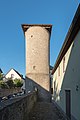
Wall tower between Falterstraße 33 and 35, city side
more pictures


| location | object | description | File no. | image |
|---|---|---|---|---|
| Falterstrasse 35 ( location ) |
Faltertor | Three-story gate tower, around 1550 | D-6-75-117-44 |
 more pictures |
The eastern wall line runs from the Faltertor to the breakthrough on Bamberger Straße:
- Eastern city wall ( location ): city wall along the street, rest of the city wall with round towers, 15th century
- Eastern city wall 1 ( location ): wall tower, expanded round tower of the city fortifications, around 1500
- Eastern city wall 3 ( location ): wall tower, expanded round tower of the city fortifications, around 1500
- Eastern city wall 5 ( location ): wall tower, expanded round tower of the city fortifications, around 1500
- Eastern city wall, near Hirtengasse 12 ( location ): wall tower, 15./16. century
- east of Hirtengasse 4 ( location ): rest of the city wall and round tower, 15./16. century

Wall tower on the eastern city wall
more pictures
Mauerturm Ostliche Stadtmauer 1
more pictures
Wall tower Eastern city wall 3
more pictures
Wall tower Eastern city wall 5
more pictures
Wall tower Eastern city wall near Hirtengasse 12
more pictures
southernmost wall tower Eastern city wall
more pictures


The southern wall line runs closed from Bamberger Straße to Am Bach:
- Südring ( location ): Along the street, rest of the city wall with round towers
- South of Südring 13 ( location ): wall tower, round tower
- South of Südring 9 ( location ): wall tower, round tower
- Südring 6 ( location ): wall tower, expanded round tower of the city fortifications, around 1500
- Südring 4 ( location ): Wall tower, expanded round tower of the city fortifications, around 1500
- Südring 2 ( location ): wall tower, expanded round tower of the city fortifications, around 1500
- South of Südring 3 ( location ): wall tower, round tower
Wall tower at Südring 13
more pictures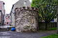
Wall tower at Südring 9
more pictures
Wall tower Südring 6
more pictures
Wall tower Südring 4
more pictures
Wall tower Südring 2
more pictures
Wall tower at Südring 3
more pictures


In the further course, a section of the wall with remains of a round tower is preserved at Fischergasse 1, then west from Fischergasse 9 to the confluence of Fischergasse in Mainstockheimer Straße:
- Near Fischergasse 1 ( location ): rest of the city wall, 15./16. century
- Near Fischergasse 1 ( location ): wall tower, round tower, 15./16. century
- Near Fischergasse 7 ( location ): rest of the city wall, 15./16. century
- Fischergasse 9 ( location ): wall tower, round tower, 15./16. century
- Fischergasse 9 ( location ): rest of the city wall, 15./16. century
- Fischergasse 13 ( location ): rest of the city wall, 15./16. century
- Fischergasse 13 ( location ): wall tower, round tower, 15./16. century

Wall tower at Fischergasse 9
more pictures
City wall at Fischergasse 9
more pictures
Wall tower at Fischergasse 13
more pictures


Western wall line from the breakthrough on Fischergasse, west of Am Stadtgraben to the breakthrough at the defunct Würzburger Tor:
- At the Stadtgraben ( location ): Along the street, the rest of the city wall with four expanded and four incompletely preserved towers, 15th / 16th centuries. century
- Am Stadtgraben 6 ( location ): Wall tower, 15./16. century
- Am Sperber 2 ( location ): wall tower, 15./16. century
- Near Fischergasse 27 ( location ): Wall tower, 15./16. century
- Near Dr.-Matthias-Horn-Straße 16, 18 ( location ): Wall tower, 15./16. century
- Am Stadtgraben 4 ( location ): Wall tower, 15./16. century
- Am Stadtgraben 2 ( location ): Wall tower, 15./16. century
- Near Dr.-Matthias-Horn-Straße 6 ( location ): Wall tower, 15./16. century
- Near Dr.-Matthias-Horn-Straße 2 ( location ): Wall tower, 15./16. century
- Near Würzburger Straße 15 ( location ): Wall tower, 15./16. century
Wall tower, Am Stadtgraben 6
more pictures
Wall tower, Am Sperber 2
more pictures
Wall tower, opposite Fischergasse 27
more pictures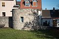
Wall tower, opposite Am Stadtgraben 3
more pictures
Wall tower, Am Stadtgraben 4
more pictures
Wall tower, Am Stadtgraben 2
more pictures
Wall tower, Am Stadtgraben 2
more pictures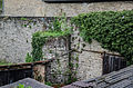
Wall tower in the city moat, near Dr.-Matthias-Horn-Straße 6
more pictures
Wall tower, near Dr.-Matthias-Horn-Straße 2
more pictures
Wall tower, near Dr.-Matthias-Horn-Straße 2
more pictures
Wall tower, Würzburger Straße 15
more pictures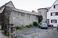
Wall tower, Würzburger Straße 15
more pictures


North of Würzburger Strasse, the wall procession begins at Bahnhofstrasse 2 and runs west of the western city wall alley to the wall breakthrough on Langgasse:
- Western city wall ( location ): Along the street, remainder of the city wall with round towers, 15th century
- Near Bahnhofstraße 2 ( location ): wall tower, round tower
- Near Bahnhofstrasse 4 ( location ): wall tower, round tower
- Near the western city wall 1 ( location ): wall tower, round tower

Wall tower, Bahnhofstraße 2
more pictures
Wall tower, Bahnhofstraße 2
more pictures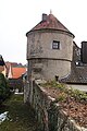
Wall tower, Bahnhofstraße 2
more pictures
Wall tower, Bahnhofstraße 4, city side
more pictures
Mauerturm, Westliche Stadtmauer 1
more pictures


Architectural monuments according to districts
Dettelbach
Individual monuments within the Old Town ensemble
| location | object | description | File no. | image |
|---|---|---|---|---|
| Bamberger Straße 1 ( location ) |
Residential building | Two-storey mansard roof building with drilled window frames, 18th century | D-6-75-117-5 |
 more pictures |
| Bamberger Straße 3 ( location ) |
Mansard roof house | Two-story building with a half-timbered upper floor, 18th century | D-6-75-117-6 |
 more pictures |
| Bamberger Straße 5 ( location ) |
Gabled house | Two-story half-hipped roof building, upper floor half-timbered, 17th century | D-6-75-117-7 |
 more pictures |
| Bamberger Straße 6, 8 ( location ) |
Eaves side courtyard | Two-storey solid construction with drilled window frames and pilaster portal, first half of the 18th century | D-6-75-117-8 |
 more pictures |
| Bamberger Straße 10, 12 ( location ) |
Eaves side courtyard | Three-storey solid building with drilled window frames and arched portal, 18th century | D-6-75-117-9 |
 more pictures |
| Bamberger Straße 15 ( location ) |
Gasthof Zum Goldenen Adler | Two-storey mansard roof, marked "1753" | D-6-75-117-10 |
 more pictures |
| Bamberger Straße 15 ( location ) |
boom | Second half of the 18th century | D-6-75-117-10 |
 more pictures |
| Bamberger Straße 20 ( location ) |
House figure | Madonna, 19th century | D-6-75-117-11 |
 more pictures |
| Birklinger Hof 3 ( location ) |
Residential building | Three-storey solid building with hipped roof, 16th century | D-6-75-117-12 |
 more pictures |
| Birklinger Hof 8 ( location ) |
Birklinger Hof, former Zehnthof | Two-storey solid building with a gable roof, labeled "1550" | D-6-75-117-13 |
 more pictures |
| Birklinger Hof 9 ( location ) |
Residential building | Two-storey eaves side building, 18./19. century | D-6-75-117-14 |
 more pictures |
| Birklinger Hof 11 ( location ) |
Residential building | Two-storey corner building with a mansard roof, labeled "1817", over the older core | D-6-75-117-15 |
 more pictures |
| Birklinger Hof 11 ( location ) |
House figure | Saint Wendelin, 18th century | D-6-75-117-15 |
 more pictures |
| Birklinger Hof 12 ( location ) |
House figure | Madonna and Child, 18th century | D-6-75-117-16 |
 more pictures |
| Bohnmühlgasse 9, Eichgasse 1 ( location ) |
Residential and commercial building | Two-storey corner building with a mansard roof, 18th century | D-6-75-117-17 |
 more pictures |
| Castle moat 2 ( location ) |
Former Zehnthof, then Franciscan convent, now a winery | Elongated three-storey solid building with a gable roof, over extensive, probably post-medieval cellar vaults, partly renewed in the 19th and 20th centuries | D-6-75-117-37 |
 more pictures |
| Castle moat 2 ( location ) |
archway | 17./18. Century, part of the Apfelbacher winery | D-6-75-117-24 |
 more pictures |
| Dr. Mathias-Horn-Straße 2, in the courtyard of the property ( ) |
Wayside shrine | With Pietà
not re-qualified, not mapped in the Bavarian Monument Atlas |
D-6-75-117-19 | |
| Eichgasse 3 ( location ) |
Residential building | Three-storey eaves side building with figure niche, labeled "1770" | D-6-75-117-20 |
 more pictures |
| Eichgasse 4 ( location ) |
House figure | Saint Nepomuk, sandstone, 18th century | D-6-75-117-21 |
 more pictures |
| Eichgasse 5 ( location ) |
Residential and commercial building | Two-storey eaves side building with half-timbered upper storey, 18th century | D-6-75-117-22 |
 more pictures |
| Eichgasse 7 ( location ) |
Residential building | Two-storey gable building with half-timbered upper storey, 17th century | D-6-75-117-23 |
 more pictures |
| Eichgasse 10 ( location ) |
House figure | Vesper picture, sandstone, inscribed "1705" | D-6-75-117-25 |
 more pictures |
| Eichgasse 19 ( location ) |
Residential building | Two-storey half-hipped roof building with wooden arbor and half-timbered gable, 16./17. century | D-6-75-117-27 |
 more pictures |
| Eichgasse 24 ( location ) |
Door framing | Sandstone, inscribed "1720" | D-6-75-117-28 |
 more pictures |
| Eichgasse 24 ( location ) |
House figure | Mary with the Child, early 18th century | D-6-75-117-28 |
 more pictures |
| Erbsengasse 5 ( location ) |
Residential building | Two-storey eaves side building with half-timbered upper storey, 18th century | D-6-75-117-29 | |
| Erbsengasse 7 ( location ) |
Residential and commercial building | Three-story solid building with hipped roof, 18th century | D-6-75-117-30 |
 more pictures |
| Falterstrasse 2 ( location ) |
Gasthof Zum Grünen Baum | Two-storey eaves side building with drilled window and door frames, marked "1782" | D-6-75-117-31 |
 more pictures |
| Falterstrasse 2 ( location ) |
boom | Iron, second half of the 18th century | D-6-75-117-31 |
 more pictures |
| Falterstrasse 4 ( location ) |
Residential building | Two-storey gable building with half hip, drilled window frames and half-timbered gable, 18th century | D-6-75-117-32 |
 more pictures |
| Falterstrasse 8 ( location ) |
Residential building | Two-storey half-hipped roof building with a protruding upper storey, in the core 16./17. century | D-6-75-117-33 |
 more pictures |
| Falterstrasse 9 ( location ) |
Residential building | Two-story corner building with hipped roof, upper floor plastered half-timbering, 18th century (above core from 1471) | D-6-75-117-34 |
 more pictures |
| Falterstrasse 11 ( location ) |
Residential building | Three-story hipped roof building with drilled window and door frames, 18th century | D-6-75-117-35 |
 more pictures |
| Falterstrasse 12 ( location ) |
Residential building | Two-storey eaves side house, upper floor plastered half-timbering, in the core 17th / 18th. century | D-6-75-117-36 |
 more pictures |
| Falterstrasse 16 ( location ) |
Eaves side house | Two-storey building with arched gate entrance, classicistic, inscribed "1834" | D-6-75-117-38 |
 more pictures |
| Falterstrasse 20 ( location ) |
House figure | Immaculata, sandstone, 19th century | D-6-75-117-39 |
 more pictures |
| Falterstraße 22 ( location ) |
Residential building | Two-storey eaves side house, upper storey plastered half-timbering, 17th century | D-6-75-117-40 |
 more pictures |
| Falterstraße 22 ( location ) |
House figure | Pietà, 17th century | D-6-75-117-40 |
 more pictures |
| Falterstrasse 23 ( location ) |
Courtyard | Two-storey baroque complex, street wing with drilled window frames and embossed portal, 18th century | D-6-75-117-41 |
 more pictures |
| Falterstrasse 24 ( location ) |
Cornerstone | Sandstone, 18th century, built into the new building | D-6-75-117-42 |
 more pictures |
| Falterstrasse 29 ( location ) |
Residential building | Two-storey gable building, 17th century | D-6-75-117-43 |
 more pictures |
| Fischergasse 9 ( location ) |
House figure | Saint Elizabeth, 18th century | D-6-75-117-45 | |
| Fischergasse 10 ( location ) |
Courtyard | Two-storey house with a plastered half-timbered upper floor, labeled "1619" | D-6-75-117-46 |
 more pictures |
| Fischergasse 12 ( location ) |
House figure | Christ with globe, 17th century | D-6-75-117-47 |
 more pictures |
| Fischergasse 23 ( location ) |
Residential building | Three-storey eaves side building, marked "1566" | D-6-75-117-49 |
 more pictures |
| Häfner Markt 5 ( location ) |
Inn | Three-storey half-hipped roof building with half-timbered upper storey, labeled "1569" and "1719" | D-6-75-117-50 |
 more pictures |
| Hirtengasse 12 ( location ) |
Saint figure | Saint Vincent de Paul with child, sandstone, 17th / 18th centuries century | D-6-75-117-52 |
 more pictures |
| Hutergasse 1a, 3 ( location ) |
Duplex | Two-storey eaves side building with half hipped, upper storey plastered timber frame, 17th century | D-6-75-117-53 |
 more pictures |
| Hutergasse 1a, Hutergasse 3 ( location ) |
House figure | Sandstone, 17th / 18th centuries century | D-6-75-117-53 |
 more pictures |
| Hutergasse 6 ( location ) |
Residential building | Two-storey mansard half-hipped roof, 18th century | D-6-75-117-54 |
 more pictures |
| Hutergasse 11 ( location ) |
Residential building | Two-storey gable building, upper floor plastered half-timbering, 17th / 18th centuries century | D-6-75-117-55 |
 more pictures |
| Kirchplatz 1 ( location ) |
Catholic Parish Church of St. Augustine | Irregular system from two construction periods with a polygonal choir and a drawn-in western section, tower around 1444, 1498–1503 and 1769–1774; with equipment ( protected cultural property ) |
D-6-75-117-56 |
 more pictures |
| Kirchplatz ( location ) |
Church terrace | On high substructures, medieval | D-6-75-117-56 |
 more pictures |
| Kirchplatz 2 ( location ) |
Former sacristan's house, now a local museum | Two- and three-storey saddle roof construction, plastered half-timbering, inscribed “1565” and “18. Century" | D-6-75-117-227 |
 more pictures |
| Kirchplatz 3 ( location ) |
Former rent office, now winery, first tithe winery (single-storey wine press hall above historical vaulted cellar), then rent office and police station, today residential building | Two-storey hipped roof building, marked "1548" | D-6-75-117-57 |
 more pictures |
| Kühngasse ( location ) |
Statue | Coronation of Mary, sandstone, 18th century | D-6-75-117-93 |
 more pictures |
| Luitpold-Baumann-Strasse, Neuseser Strasse 2 ( location ) |
Sandstone figure of the Good Shepherd | On a console, late baroque, inscribed "1749;" in a niche | D-6-75-117-418 |
 more pictures |
| Maingasse 6 ( location ) |
Residential building | Two-storey half-hipped roof building with half-timbered upper storey, 18th / 19th centuries century | D-6-75-117-61 |
 more pictures |
| Maingasse 6 ( location ) |
relief | With a cross tractor, 18th century | D-6-75-117-61 |
 more pictures |
| Mansgasse 6 ( location ) |
House figure | Immaculata, 17./18. century | D-6-75-117-62 |

|
| Mansgasse 13 ( location ) |
House figure | Sandstone Vespers, 18th century | D-6-75-117-63 |

|
| Market 1 ( location ) |
Gasthof zur Sonne | Two-storey mansard roof building on a broken floor plan, with drilled window frames, inscribed "1781" | D-6-75-117-64 |
 more pictures |
| Market 3 ( ) |
House figure | Immaculata, 18th century
not re-qualified, not mapped in the Bavarian Monument Atlas |
D-6-75-117-65 | |
| Market 4 ( location ) |
Residential and commercial building | Two-storey corner building with a gable roof, 18th century | D-6-75-117-66 |
 more pictures |
| Market 5 ( location ) |
Residential and commercial hay | Three-storey eaves side building, marked "1835" | D-6-75-117-67 |
 more pictures |
| Market 7 ( location ) |
Residential and commercial building | Three-storey gable building, half-timbered, inscribed "1577" | D-6-75-117-68 |
 more pictures |
| Market 9 ( location ) |
Residential and commercial building | Two-storey gable building, plastered half-timbering, 17th century | D-6-75-117-69 |
 more pictures |
| Market 13 ( location ) |
Community center | So-called Baumann's house, two-storey half-timbered building with a saddle roof, partly plastered, labeled "1478" and "1536" | D-6-75-117-70 |
 more pictures |
| Eastern city wall 2 ( location ) |
Residential building | Two-wing hipped roof building with drilled window frames, 18th century | D-6-75-117-77 |
 more pictures |
| Rathausplatz ( location ) |
Bridge figure | Saint Nepomuk, sandstone, inscribed "1719" | D-6-75-117-81 |
 more pictures |
| Rathausplatz 1 ( location ) |
town hall | Three-storey saddle roof building with outside staircase and central bay, 1484–1512; with equipment | D-6-75-117-80 |
 more pictures |
| Vines hill 9 ( location ) |
Gabled house | Plastered framework, 17th / 18th centuries century | D-6-75-117-83 |
 more pictures |
| Vines hill 11 ( location ) |
House figure | Madonna, 17./18. century | D-6-75-117-84 |
 more pictures |
| Vines hill 17 ( location ) |
Courtyard gate | Arch passage with sandstone walls, 18./19. century | D-6-75-117-85 |
 more pictures |
| Dead end 2 ( location ) |
House figure | Saint. Nepomuk, sandstone, 17th century | D-6-75-117-86 |
 more pictures |
| Dead end 5 ( location ) |
Residential building | Two-storey gable building with a central bay, the core of the 16th century | D-6-75-117-87 |
 more pictures |
| Dead end 5, inside the barn ( location ) |
Arched frieze | On consoles, marked "158" | D-6-75-117-87 | |
| Dead-end 7 ( location ) |
House figure | Vespers picture, 18th century | D-6-75-117-88 |
 more pictures |
| Schweinfurter Strasse 1 ( location ) |
Residential building | Two-storey gable building with half-timbered upper storey, 17th century | D-6-75-117-89 |
 more pictures |
| Schweinfurter Strasse 2 ( location ) |
Stone relief | Caritas, 17th century | D-6-75-117-90 |

|
| Schweinfurter Strasse 3 ( location ) |
Residential building | Two-storey gable roof building, half-timbered, 17th century | D-6-75-117-91 |
 more pictures |
| Schweinfurter Strasse 13 ( location ) |
Residential building | Two-storey half-hipped roof building with plastered half-timbered upper storey, decorative wrought-iron balcony and surrounding wall, inscribed "1666" | D-6-75-117-92 |
 more pictures |
| Spitalgasse 1, 3 ( location ) |
Residential building | Two-storey eaves side building with half-timbered upper storey, 17th century | D-6-75-117-95 |
 more pictures |
| Spitalgasse 4 ( location ) |
Residential building | Two-storey gable building with half-timbered upper storey, 17th century | D-6-75-117-96 |
 more pictures |
| Spitalgasse 10 ( location ) |
Hospital, now retirement home | Two-storey solid construction with hipped roof, foundation from 1481, new building 1785 | D-6-75-117-97 |
 more pictures |
| Spitalgasse 10 ( location ) |
Hospital, heraldic relief | Sandstone, inscribed "1531" | D-6-75-117-97 |
 more pictures |
| Würzburger Strasse 2 ( location ) |
House figure | Madonna, 19th century | D-6-75-117-106 | |
| Würzburger Strasse 3 ( location ) |
Residential building | Two-storey half-hipped roof building, marked "1579" | D-6-75-117-107 |
 more pictures |
| Würzburger Strasse 4 ( location ) |
Residential building | Two-story eaves side building, upper floor plastered timber frame, 17th / 18th centuries century | D-6-75-117-108 |
 more pictures |
| Würzburger Strasse 5 ( location ) |
House figure | Pietà, sandstone, 17th century | D-6-75-117-109 | |
| Würzburger Strasse 7 ( location ) |
door | Inscribed "1783" | D-6-75-117-110 |
 more pictures |
| Würzburger Strasse 8 ( location ) |
Residential building | Two-storey eaves side building with half hipped and plastered half-timbered upper storey, marked "1787" | D-6-75-117-111 |
 more pictures |
| Würzburger Strasse 10 ( location ) |
Eaves side courtyard | Two-storey hipped roof building with plastered half-timbered upper storey, 17th century | D-6-75-117-112 |
 more pictures |
| Würzburger Straße 11, 13 ( location ) |
Eaves side courtyard | Two-storey saddle roof building with half-timbered upper storey, labeled "1623" | D-6-75-117-114 |
 more pictures |
Individual monuments of the remaining core city
| location | object | description | File no. | image |
|---|---|---|---|---|
| Am Edelmannsweg, Beim Wallfahrtsweg, gravel ( location ) |
Stations of the Cross | Twelve green sandstone pedicels with colored high reliefs made of clay, 19th century | D-6-75-117-215 | |
| At the Felsenkeller ( location ) |
Wayside shrine | With monstrance of the Holy of Holies and angels, sandstone, around 1730 | D-6-75-117-124 | |
| Am Güthlein ( location ) |
Wayside shrine | With Pietà and Saint Anna, sandstone, inscribed "1773" | D-6-75-117-127 | |
| Am Lehnstein ( location ) |
Wayside shrine | With Pietà, sandstone, inscribed "1607" | D-6-75-117-126 | |
| At the lead 4 ( location ) |
Statue | With Trinity, sandstone, inscribed "1732" | D-6-75-117-132 | |
| At the lead 4 ( location ) |
Statue | With Trinity, sandstone, inscribed "1761" | D-6-75-117-131 | |
| At the lead 4 ( location ) |
Figure niche | Nit pain man, sandstone, 18./19. century | D-6-75-117-133 | |
| Brücker Holz ( location ) |
Torture column with crucifixion | Sandstone, inscribed "1602" | D-6-75-117-128 | |
| Brücker Holz ( location ) |
Statue | With angel and medallion with Trinity, sandstone, inscribed "1784" | D-6-75-117-129 |
 more pictures |
| Castle moat, on the northern city wall ( location ) |
Pietà | Sandstone, marked “1730”, renewed in 1902 | D-6-75-117-2 | |
| Hedge ( location ) |
Christ figure | Sandstone, column structure marked "1900", figure marked "1955" | D-6-75-117-120 | |
| Lochrötenweg ( location ) |
Chapel niche | With Trinity, a small solid building with a gable roof, inscribed "1836" | D-6-75-117-118 | |
| Maing gardens ( location ) |
Wayside shrine | With the Annunciation, crucifix and Trinity, inscribed "1608" | D-6-75-117-123 | |
| Mainstockheimer Berge ( location ) |
Wayside shrine | With Trinity, sandstone, 18th century | D-6-75-117-121 | |
| Mainstockheimer Berge ( location ) |
Joseph stamp | Step system with figure of St. Joseph with child, inscribed "1892" | D-6-75-117-122 | |
| ( ) | Pillar of torture | With crucifixion, sandstone, 18th century
not re-qualified, not mapped in the Bavarian Monument Atlas |
D-6-75-117-119 | |
| Nachtigallenstrasse ( location ) |
Cross tug | Sandstone, 18th century | D-6-75-117-116 | |
| Nachtigallenstraße 31 ( location ) |
Former Steigmühle inn | two-storey mansard roof, around 1800 | D-6-75-117-72 | |
| Nachtigallenstrasse 35 ( location ) |
Hellersmühle | Two-storey quarry stone building with a half-hip, 18th / 19th centuries century | D-6-75-117-73 | |
| Nachtigallenstrasse 35 ( location ) |
Remise | Single-storey quarry stone building with gable roof, 18th / 19th centuries century | D-6-75-117-73 | |
| Near Hans-Löffler-Straße ( location ) |
Torture column, so-called Lorenzmarter | With crucifixion, sandstone, inscribed "1514" and "1608" | D-6-75-117-125 |
 more pictures |
| Near Hans-Löffler-Straße ( location ) |
Wayside shrine | With crucifixion group and donors, inscribed "1513" | D-6-75-117-226 | |
| Neuseser Straße 1 ( location ) |
Statue | Kreuzschlepper, sandstone, inscribed "1704" | D-6-75-117-74 | |
| Ober der Hellersmühle ( location ) |
Chapel niche | With the Fourteen Helpers and the Trinity, small solid building with a gable roof, first half of the 19th century | D-6-75-117-117 |
 more pictures |
| Schweinfurter Strasse ( location ) |
Pillar of torture | With crucifixion, sandstone, inscribed "1671" | D-6-75-117-130 |

|
| Schweinfurter Strasse 34 ( location ) |
Lamprechtsmühle, former mill building with residential building | Two-storey solid building with a gable roof, marked "1607" | D-6-75-117-94 | |
| Schweinfurter Strasse 34 ( location ) |
Lamprechtsmühle, threshing floor | Single-storey quarry stone building with gable roof, 18th / 19th centuries century | D-6-75-117-94 | |
| Schweinfurter Strasse 34 ( location ) |
Lamprechtsmühle, barn | Single-storey solid building with gable roof, 18th / 19th centuries Century; over older core | D-6-75-117-94 | |
| Pilgrimage route ( location ) |
Stations of the Cross | Natural stone grottoes with relief panels, inscribed "1894" | D-6-75-117-103 | |
| Pilgrimage route 4 ( location ) |
Wayside shrine | With crucifixion, sandstone, inscribed "1603" | D-6-75-117-102 | |
| Pilgrimage route 16 ( location ) |
Catholic pilgrimage and Franciscan monastery church Maria im Sande | Cruciform structure with retracted long choir, post-Gothic 1610–13, choir 1506–23; with equipment | D-6-75-117-104 |
 more pictures |
| Pilgrimage route ( location ) |
Wayside shrine | With Resurrection and Pietà, sandstone, inscribed "1617" | D-6-75-117-104 |
 more pictures |
| Pilgrimage route ( location ) |
Processional altar | With depictions of the Passion of Christ, 17th century | D-6-75-117-104 | |
| Pilgrimage route ( location ) |
Wayside shrine | With Descent from the Cross, inscribed "1606", renewed in 1960 | D-6-75-117-104 |
 more pictures |
| Pilgrimage route 18 ( location ) |
Franciscan monastery Maria im Sand, four-wing complex, main building | With ornamental gable and portal, inscribed "1617" | D-6-75-117-104 |
 more pictures |
| Würzburger Strasse 16 ( location ) |
Torture column depicting the way to Golgotha | Sandstone, inscribed "1608" | D-6-75-117-115 |
Bibergau
| location | object | description | File no. | image |
|---|---|---|---|---|
| Am Dettelbacher Weg ( location ) |
Picture house | With relief plaque of the Fourteen Holy Helpers and the Trinity, inscribed "1872" | D-6-75-117-143 |
 more pictures |
| Am Dettelbacher Weg ( location ) |
Picture house | With sandstone relief of the Holy Family, inscribed "1836" | D-6-75-117-144 | |
| Effeldorfer Strasse 2; in the courtyard wall ( location ) |
Sandstone relief | With Pietà, inscribed "1693" | D-6-75-117-138 | |
| On the road to Euerfeld ( ) |
cross | Inscribed "1812"
not re-qualified, not mapped in the Bavarian Monument Atlas |
D-6-75-117-141 | |
| Lindenstrasse 1 ( location ) |
Catholic Parish Church of St. Simon and Jude | Hall building with choir tower from 1630, nave 1732; with equipment | D-6-75-117-134 |
 more pictures |
| Near the cross; am Schernauer Weg ( location ) |
crucifix | Inscribed "1894" | D-6-75-117-142 | |
| Near Ritterstrasse; Corner of Katharinenberg ( location ) |
Wayside shrine | Aedicula with Mount of Olives scene, inscribed "1893" | D-6-75-117-216 | |
| Ritterstrasse ( location ) |
Chapel niche | With the Coronation of Mary and the Fourteen Holy Helpers, sandstone, 18th century | D-6-75-117-139 | |
| Ritterstrasse 15 ( location ) |
Cross tug | Sandstone, 18th century | D-6-75-117-135 |

|
| Ritterstrasse 17 ( location ) |
Farmhouse | Two-storey solid building with half hip and half-timbered gable, 18./19. century | D-6-75-117-136 |
 more pictures |
| Ritterstrasse 22 ( location ) |
Manor, former pond house | Two-storey solid building with stepped gable, 16th century, stair tower older | D-6-75-117-140 |

|
| Ritterstrasse; Ritterstrasse 21 ( location ) |
Courtyard gate posts | Sandstone, 19th century | D-6-75-117-137 |
Bridge
| location | object | description | File no. | image |
|---|---|---|---|---|
| Lindenbergweg 1; Lindenbergweg 3 ( location ) |
Catholic branch church St. Markus and Jakobus | Hall church with flat ceiling and polygonal choir, late 17th century, tower basement Romanesque, extended in 1846; with equipment | D-6-75-117-145 |
 more pictures |
| Lindenbergweg 1; Lindenbergweg 3 ( location ) |
Statue | With Vespers picture, at the entrance to the church, sandstone, inscribed "1720" | D-6-75-117-145 |
 more pictures |
| Steinäcker; on the road to Schnepfenbach ( location ) |
Wayside shrine | With Pietà, inscribed "1897" | D-6-75-117-146 |
 more pictures |
Effeldorf
| location | object | description | File no. | image |
|---|---|---|---|---|
| At the village fountain ( location ) |
Wayside shrine | With tricky Luke, sandstone, 18th century | D-6-75-117-159 | |
| At the village fountain 2; Jesuitenstrasse 14 ( location ) |
Courtyard gate posts | Sandstone, early 19th century | D-6-75-117-150 | |
| Am Dorfbrunnen 6 ( location ) |
House relief | Vesper picture, sandstone, 18th century | D-6-75-117-149 | |
| Heinrich-Schatzel-Strasse ( location ) |
Statue | With crucifixion, sandstone, inscribed "1602" | D-6-75-117-153 | |
| Jesuitenstrasse ( location ) |
Wayside shrine | With St. John, sandstone, inscribed "1726" | D-6-75-117-148 | |
| Jesuitenstrasse ( location ) |
crucifix | Inscribed "1864" | D-6-75-117-157 | |
| Jesuitenstrasse 6 ( location ) |
Residential building | Two-storey hipped roof building with half-timbered upper storey, labeled "1836" | D-6-75-117-152 |
 more pictures |
| Jesuitenstrasse 6 ( location ) |
Gate gable | Sandstone, inscribed "1690" | D-6-75-117-152 |

|
| Jesuitenstrasse 10 ( location ) |
Door stone | Marked "1690" | D-6-75-117-151 |

|
| Jesuitenstrasse 13 ( location ) |
Former rectory | Two-storey saddle roof construction, quarry stone masonry with house framing, with extension and pump well, 1869 | D-6-75-117-233 | |
| Jesuitenstrasse 16 ( location ) |
Catholic Parish Church of St. James the Elder | Choir 1653, nave 1753; with equipment | D-6-75-117-147 |
 more pictures |
| Katzental ( location ) |
Wayside shrine, so-called seven-head torture | Chamfered pillar with a leaf capital and a three-sided top with reliefs of the crucifixion and the flanking hll. Stephanus and Felicitas, sandstone, late Gothic, around 1500 | D-6-75-117-420 | |
| Kirchhofsweg ( location ) |
Chapel niche | With relief of St. Matthew, sandstone, 18th century | D-6-75-117-154 | |
| Long length ( location ) |
cross | With Pietà, sandstone, inscribed "1846" | D-6-75-117-160 | |
| Near Heinrich-Schatzel-Straße ( location ) |
Wayside shrine | Sandstone, 19th century | D-6-75-117-158 | |
| Near Rothofer Strasse; Rothofer Strasse 4 ( location ) |
Courtyard gate | Sandstone, mid-19th century | D-6-75-117-155 | |
| Rothofer Strasse 2 ( location ) |
Courtyard gate posts | Sandstone, 19th century | D-6-75-117-156 |
Your field
| location | object | description | File no. | image |
|---|---|---|---|---|
| on Kürnacher Weg ( ) |
Statue | With the Trinity and the beheading of St. Catherine
not re-qualified, not mapped in the Bavarian Monument Atlas |
D-6-75-117-179 | |
| 200 m west of Herrengarten 1 ( ) |
Statue | With Maria and child
not re-qualified, not mapped in the Bavarian Monument Atlas |
D-6-75-117-183 | |
| Bräugasse 2 ( location ) |
Courtyard gate posts | Marked "181" 6 | D-6-75-117-164 | |
| Fruehlingsgasse 8 ( location ) |
relief | with Holy Family, sandstone, inscribed 1694 | D-6-75-117-170 | |
| Gable wall ( location ) |
Statue | With Pietà and two apostles, sandstone, inscribed "1705" | D-6-75-117-181 | |
| Güßgraben ( location ) |
Statue | With Anna Selbdritt and Saint Michael, sandstone, 18th century | D-6-75-117-180 | |
| Hauptstrasse 2 ( location ) |
Pillar of torture | With Pietà, inscribed "1725" | D-6-75-117-167 | |
| Hauptstrasse 20 ( location ) |
Former school and town hall | Single-storey, massive half-hipped roof building with a basement protruding from the slope, marked "1789" | D-6-75-117-419 | |
| Kirchstrasse 21 ( location ) |
Catholic Parish Church of St. Michael | Hall church with polygonal choir, west tower marked “1617”, nave 1627, choir and transept 1892; with equipment | D-6-75-117-161 |
 more pictures |
| Kirchstrasse 21 ( location ) |
Statue | With crucifixion, sandstone, inscribed "1565" | D-6-75-117-161 |
 more pictures |
| Near Kirchstrasse ( location ) |
Priests' graves | Four sandstone grave monuments, historicist, 19th century and 1902 | D-6-75-117-234 | |
| at Steinbrücher Weg ( ) |
cross | Inscribed "1879"
not re-qualified, not mapped in the Bavarian Monument Atlas |
D-6-75-117-175 | |
| Lindenallee 16 ( location ) |
Chapel niche | With the Fourteen Holy Helpers and the Coronation of Mary, sandstone, inscribed "1844" | D-6-75-117-162 | |
| Lindenallee 34 ( location ) |
Pillar of torture | with Pietà, St. Josef and Child, sandstone, inscribed 1721 | D-6-75-117-176 | |
| ( ) | Pillar of torture | With Pietà and donor figures, around 1830/40; reduced
not re-qualified, not mapped in the Bavarian Monument Atlas |
D-6-75-117-169 | |
| at the fork in the Alter Steinbrücher Weg / Röttendorfer Weg ( us ) |
Pillar of torture | With Pietà, inscribed "1871"
not re-qualified, not mapped in the Bavarian Monument Atlas |
D-6-75-117-174 | |
| Mödig ( location ) |
Chapel niche | With Trinity, sandstone, inscribed "1865" | D-6-75-117-173 | |
| Near main street ( location ) |
Cross tug | Sandstone, 18th / 19th centuries century | D-6-75-117-166 | |
| Near Kaiserstraße ( location ) |
Crucifixion group | Sandstone, inscribed "1855" | D-6-75-117-163 | |
| Near Kaiserstraße ( location ) |
Picture house | With Trinity and the Fourteen Holy Helpers, sandstone, inscribed "1870" | D-6-75-117-178 | |
| Ödsfelder Kreuz ( location ) |
crucifix | Sandstone, inscribed "1891" | D-6-75-117-182 | |
| Säubrünnlein ( location ) |
crucifix | Sandstone, inscribed "1891" | D-6-75-117-171 | |
| Säubrünnlein ( location ) |
Statue with crucifixion | Sandstone, inscribed "1603" | D-6-75-117-172 |
 more pictures |
| Trappenberg ( location ) |
crucifix | Sandstone, inscribed "1857" | D-6-75-117-177 | |
| Weihergasse 2 ( location ) |
Cross tug | Sandstone, inscribed "1695" | D-6-75-117-168 |
Kürnach
| location | object | description | File no. | image |
|---|---|---|---|---|
| Straßholz ( location ) |
Wayside shrine | Relief attachment with crucifixion scene, on pillar above table base, sandstone, inscribed "1748" | D-6-79-156-1 |
Mainsondheim
| location | object | description | File no. | image |
|---|---|---|---|---|
| Albertshofener Straße, on the castle wall ( location ) |
Pillar of torture with a cruiser | D-6-75-117-191 |
 more pictures |
|
| Albertshofener Straße, on the castle wall ( location ) |
Wayside shrine | With Pietà and the 14 helpers in need | D-6-75-117-193 | |
| Albertshofener Straße 4 ( location ) |
Small farmhouse | Single-storey gable-independent saddle roof building with half-timbered gable, 17th / 18th centuries century | D-6-75-117-184 |
 more pictures |
| Albertshofener Straße 9 ( location ) |
Former forester's house, residential building | Two-storey eaves building with hipped roof with drilled window frames, late 18th century | D-6-75-117-185 |
 more pictures |
| Albertshofener Straße 12 ( location ) |
Catholic Parish Church of Mary (Mother of Jesus) | Choir tower 15th century, nave 1583, modified in 1705; with equipment | D-6-75-117-186 |
 more pictures |
| at the "Steinweg" ( location ) |
Wayside shrine with Golgotha scene | Inscribed "1725"
not re-qualified |
D-6-75-117-192 | |
| Hintere Kirchgasse 2 ( location ) |
grange | A group of single-storey saddle roof buildings made of exposed quarry stone masonry belonging to the castle | D-6-75-117-187 |
 more pictures |
| Hintere Kirchgasse 2 ( location ) |
Manor house | Two-storey quarry stone building with profiled window walls, 17th / 18th centuries century | D-6-75-117-187 |

|
| Hintere Kirchgasse 14a ( location ) |
Courtyard, barn | Inscribed "1793" | D-6-75-117-188 |
 more pictures |
| Hintere Kirchgasse 14a ( location ) |
Courtyard, stone relief | With crucifixion, inscribed "1655" | D-6-75-117-188 |

|
| On the road to Albertshofen ( ) |
Pillar of torture | With crucifixion
not re-qualified, not mapped in the Bavarian Monument Atlas |
D-6-75-117-190 | |
| Schloßweg 1 ( location ) |
lock | Four-wing complex with round corner towers around an irregular courtyard, stepped gable and tail gable, partly half-timbered, late Gothic / early Renaissance, 16th century, expanded after 1727, above the portal the coat of arms of the Barons of Mauchenheim called Bechtolsheim | D-6-75-117-189 | |
| To the Main ferry, on the road to Großlangheim ( location ) |
Pillar of torture | With Pietà and holy Wendelin, base inscribed "1763"; Rebuilt based on the original model in the 1960s | D-6-75-117-194 | |
| To Main ferry 1 ( location ) |
Former ferry house, residential building | Two-storey half-hipped roof building made of unplastered quarry stone masonry, with icebreaker, second half of the 18th century | D-6-75-117-1 |
 more pictures |
Neuhof
| location | object | description | File no. | image |
|---|---|---|---|---|
| Neuhof 4 ( location ) |
crucifix | Three-nail type, cross stem on base with inscription in Gothic fracture, sandstone, mounted, inscribed "1866" | D-6-75-117-225 |

|
Neuses on the mountain
| location | object | description | File no. | image |
|---|---|---|---|---|
| Dorfstrasse 16 ( location ) |
Golden Deer Inn | Two-storey, gable-free, half-hipped roof building made of unplastered quarry stone masonry, 18th century, modified in the mid-19th century | D-6-75-117-218 |
 more pictures |
| Dorfstrasse 17 ( location ) |
Residential building | Single-storey gable roof construction, windows in the massive ground floor with drilled frames, half-timbered gable, 17th / 18th centuries. century | D-6-75-117-219 |
 more pictures |
| Dorfstrasse 23 ( location ) |
Residential building | Two-storey gable roof building with half-timbering, corner post marked "1598" | D-6-75-117-220 |
 more pictures |
| Dorfstrasse 24 ( location ) |
Residential building | Two-storey, slightly set back hip roof building with half-timbered upper storey and drilled window frames, cellar arch marked "1707" | D-6-75-117-224 | |
| Dorfstrasse 27 ( location ) |
Residential building | Two-storey, gable-independent gable roof building, plastered timber framework, 15th / 16th century. century | D-6-75-117-221 |
 more pictures |
| Dorfstrasse 27 ( location ) |
barn | Inscribed "1818" | D-6-75-117-221 | |
| Dorfstrasse 29 ( location ) |
Residential building | Two-storey, gable-independent hipped roof building with plastered half-timbered upper storey, marked "1707" | D-6-75-117-222 |
 more pictures |
| Dorfstrasse 34 ( location ) |
Residential building | Two-storey gable roof building with drilled window frames, 18th century; about the core of the 16./17. Century | D-6-75-117-197 |
 more pictures |
| Dorfstrasse 34 ( location ) |
Arched courtyard gate | D-6-75-117-197 |
 more pictures |
|
| Dorfstrasse 34 ( location ) |
Madonna figure | Baroque | D-6-75-117-197 |
 more pictures |
| Dorfstrasse 36 ( location ) |
Residential building | Two-storey plastered building with a gable roof and drilled window frames, early 18th century, in the core 16th / 17th century. Century, stable area second half of the 19th century | D-6-75-117-421 |
 more pictures |
| Kirchgasse 2 ( location ) |
Former town hall | Two-storey gable-independent gable roof building with half-timbered upper storey, labeled "1576" | D-6-75-117-200 |
 more pictures |
| Kirchgasse 9 ( location ) |
Residential building | Two-storey gable-independent half-hipped roof building with half-timbered gable, quarry stone, inscribed "1803" | D-6-75-117-198 |
 more pictures |
| Kirchgasse 9 ( location ) |
Outbuildings | D-6-75-117-198 |
 more pictures |
|
| Kirchgasse 22 ( location ) |
Evangelical Lutheran Parish Church of St. Nicolai | Hall building with bell tower, built in 1784; with equipment | D-6-75-117-195 |
 more pictures |
| Kirchgasse 22 ( location ) |
Evangelical Lutheran Parish Church of St. Nicolai, extension | With mansard roof | D-6-75-117-195 | |
| Kirchgasse 20, 22 ( location ) |
Cemetery walling | D-6-75-117-195 |
 more pictures |
|
| Kirchgasse 20, 22 ( location ) |
Staircase | D-6-75-117-195 |
 more pictures |
|
| Kirchgasse 21; Kirchgasse 23 ( location ) |
Evangelical Lutheran rectory | Two-storey gable-independent saddle roof building with porch, plastered half-timbered upper storey, 18th century | D-6-75-117-199 |
 more pictures |
| Kirchgasse 21, 23 ( location ) |
Courtyard gate and gate | D-6-75-117-199 |
 more pictures |
|
| Kreuzgasse 6 ( location ) |
Catholic parish church of St. Nicholas | Hall building with polygonal choir closure and bell tower, based on a design by Major Adam Salomon Fischer, built 1784–1790; with equipment | D-6-75-117-196 |
 more pictures |
| Kreuzgasse 8 ( location ) |
Former Catholic school house | Two-storey hipped roof building with half-timbered upper storey, around 1800 | D-6-75-117-223 |
 more pictures |
New set
| location | object | description | File no. | image |
|---|---|---|---|---|
| on the way to Sulzhof ( ) |
Picture house | In the niche figure of the Pietà, 19th century
not re-qualified, not mapped in the Bavarian Monument Atlas |
D-6-75-117-206 | |
| Grund, on the road to Schnepfenbach ( location ) |
Pillar of torture | With crucifixion and Holy Family, inscribed "1745" | D-6-75-117-204 |
 more pictures |
| Near Prosselsheimer Straße; on the main street ( location ) |
Pillar of torture | Panel with crucifixion and fourteen helpers in need on the reverse, 17./18. century | D-6-75-117-203 | |
| Oberer Köhlerer Weg ( location ) |
Picture house | In the niche high relief of Mary with child, inscribed "1875" | D-6-75-117-205 | |
| Prosselsheimer Straße 17 ( location ) |
Courtyard gate posts | With classical decor, sandstone, inscribed "1858" | D-6-75-117-202 |
 more pictures |
| St 2270, on the road to Prosselsheim ( location ) |
Pillar of torture | Depicting the Crucifixion and the Fourteen Holy Helpers, inscribed "1743" and "1831" | D-6-75-117-207 | |
| Sulzhofer Straße 2 ( location ) |
Catholic branch church of the Assumption, Saint Kilian, Totnan and Kolonat | Hall building with a bell tower attached to the side, 17th century building, extended in 1766; with equipment | D-6-75-117-201 |
 more pictures |
| Sulzhofer Strasse ( location ) |
Wayside shrine | Pillar with top, round arch niche with relief of the Holy Trinity made of Carrara marble, around 1920 | D-6-75-117-235 |
Schernau
| location | object | description | File no. | image |
|---|---|---|---|---|
| Am Mutzenbrünnlein 2 ( location ) |
Evangelical Lutheran Parish Church of St. Andrew | Hall building with retracted choir and tower facade, by Thaddäus Dückelmann 1802; with equipment | D-6-75-117-208 |
 more pictures |
| Schloßstraße 17 ( location ) |
Castle, so-called Small Noble Palace | Two-storey eaves building with hipped roof, baroque, inscribed "1739" | D-6-75-117-209 |
 more pictures |
| Schloßstraße 17 ( location ) |
Castle, coat of arms of the barons of Roman | D-6-75-117-209 |

|
Schnepfenbach
| location | object | description | File no. | image |
|---|---|---|---|---|
| on Triebbergweg ( us ) |
Statue | Maria with the child, inscribed "1868"
not re-qualified, not mapped in the Bavarian Monument Atlas |
D-6-75-117-213 | |
| on the road to Dettelbach ( ) |
Wayside shrine | With a representation of the fourteen emergency helpers, inscribed "1884"
not re-qualified, not mapped in the Bavarian Monument Atlas |
D-6-75-117-211 | |
| Geiersbergweg 1; Klingenweg 1 ( location ) |
Stone crosses | Sandstone, formerly flanking the wayside shrine; spent today on the north facade of the church | D-6-75-117-212 | |
| Sankt-Kilian-Straße 15 ( location ) |
Catholic branch church St. Kilian | Hall building, neo-Gothic, around 1880; with equipment | D-6-75-117-210 |

|
Former architectural monuments
| location | object | description | File no. | image |
|---|---|---|---|---|
| Dettelbach Nachtigallenstraße 2 ( location ) |
farm | Half-hipped roof house, upper floor plastered half-timbering, 18th century | D-6-75-117-71 | |
| Dettelbach Rebenhügel 7 ( location ) |
Gabled house | Plastered framework, 17th / 18th centuries century | D-6-75-117-82 |

|
| Euerfeld Hauptstraße 13 ( location ) |
House relief | With the Coronation of Mary, 18th century | D-6-75-117-165 |
See also
Remarks
- ↑ This list may not correspond to the current status of the official list of monuments. The latter can be viewed on the Internet as a PDF using the link given under web links and is also mapped in the Bavarian Monument Atlas . Even these representations, although they are updated daily by the Bavarian State Office for Monument Preservation , do not always and everywhere reflect the current status. Therefore, the presence or absence of an object in this list or in the Bavarian Monument Atlas does not guarantee that it is currently a registered monument or not. The Bavarian List of Monuments is also an information directory. The property of a monument - and thus the legal protection - is defined in Art. 1 of the Bavarian Monument Protection Act (BayDSchG) and does not depend on the mapping in the Monument Atlas and the entry in the Bavarian Monument List. Objects that are not listed in the Bavarian Monument List can also be monuments if they meet the criteria according to Art. 1 BayDSchG. Early involvement of the Bavarian State Office for Monument Preservation according to Art. 6 BayDSchG is therefore necessary in all projects.
literature
- Denis André Chevalley: Lower Franconia . Ed .: Michael Petzet , Bavarian State Office for the Preservation of Monuments (= Monuments in Bavaria . Volume VI ). Oldenbourg, Munich 1985, ISBN 3-486-52397-X .
Web links
- Bavarian Monument Atlas (cartographic representation of the Bavarian architectural and ground monuments by the BLfD , requires JavaScript)
- List of monuments for Dettelbach (PDF) at the Bavarian State Office for Monument Preservation

Abtswind | Albertshofen | Biebelried | Buchbrunn | Castell | Dettelbach | Hostage wind | Großlangheim | Iphofen | Kitzingen | Kleinlangheim | Mainbernheim | Mainstockheim | Einersheim Market | Market wide | Marktsteft | Martinsheim | Nordheim am Main | Obernbreit | Prichsenstadt | Rödelsee | Rüdenhausen | Schwarzach am Main | Segnitz | Home of being | Sommerach | Sulzfeld am Main | Volkach | Wiesenbronn | Wiesentheid | Willanzheim