
List of architectural monuments in Prichsenstadt
The monuments of the Lower Franconian city of Prichsenstadt are compiled on this page . This table is a partial list of the list of architectural monuments in Bavaria . The basis is the Bavarian Monument List , which was first drawn up on the basis of the Bavarian Monument Protection Act of October 1, 1973 and has since been managed by the Bavarian State Office for Monument Preservation . The following information does not replace the legally binding information from the monument protection authority. This list reflects the update as of April 16, 2020 and contains 116 monuments.

Ensembles
Ensemble old town Prichsenstadt
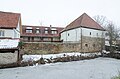
The Prichsenstadt ensemble comprises the walled old town including the pond belt on the north and south sides, which were part of the city fortifications and are connected by a deep moat on the west flank of the city. Prichsenstadt, known as a villa in the 13th century, was raised to the status of a town by Charles IV in 1367 . A fortified market was laid out east of the existing village . The village, which had sunk to a suburb, was included in the walling in the course of the 15th century. As a result, the town is divided into two halves, the dividing line of which is clearly visible and manifested in the gate tower that divides the main street in the middle. The long, rectangular ground plan of the town is supported by the main street, which used to run from gate to gate in the longitudinal axis, from west to east. It is broad and reveals its quality as a market street. In the eastern half of the city it is slightly curved, gradually widens to the west and forms a small square in front of the inner gate tower; here is the town hall , set back from the row of houses. The side streets develop mainly to the north; south of the main street there is only a short parallel lane in the eastern half of the city. The church district has moved away from the main street, it is located on the edge of the former intermediate wall. The main street has a closed development consisting of large courtyards, the houses of which are partly on the eaves and partly on the gable side. They mainly belong to the 17th / 18th centuries. Century, partly also the 19th century. The eaves-standing houses, whose stretched fronts have wide entrance gates and often half-timbered upper floors, have a decisive effect on the street scene. In the interplay with the inner gate tower and the western suburb gate, the well-preserved historical buildings condense into one of the most uniform, old Franconian cityscapes. In contrast to the closed development of the main street, a loose structure of small farms appears in the side streets, mixed with farm buildings, barns and small craftsmen and hackers' houses. Outside the main street area, the church with the vicarage and the free courtyard belonging to the farmyard of the abandoned castle form dominant building groups. The largely preserved paving of the streets and alleys are an important part of this originally preserved old town, in which the paving of the streets had already started around the middle of the 16th century. Boundary: From the suburban gate along Am Stadtgraben to Neuseser Straße - Neuseser Straße to the northeast corner of the Eichsee - east and south banks of the Eichsee - path from the former Stadtgraben from Eichsee in the east to the Oberen See in the southwest corner of the city fortifications - along Oberer See and Gerbersee to the Vorstadttor . File number: E-6-75-158-1.
City fortifications
The fortification of Prichsenstadt was created after the city elevation in 1367. The still upright parts of the wall go back to the 15th / 16th. Century back. The city tower has been preserved from the inner wall separating the actual city from the suburb. The western suburban gate of the two city gates still stands. A preserved moat extends in front of the western city wall. To the north of the city there are ponds, which originally served defensive purposes. - See Badgasse 2, 14, Schulinstrasse 28, Karlsplatz 2, Kirchgasse 7, Luitpoldstrasse 1–21 (odd numbers), 22, Mühlgasse 3–15 (odd numbers), Spitalgasse 4–18 (even numbers), Turmgasse 2, 4 , 6. Former western ramparts leading north from the Inner Gate, 14th century (cf. Karlsplatz 1, 2, Kirchgasse 1, 3). File number: D-6-75-158-1. The preserved parts of the city fortifications are following clockwise.
| location | object | description | File no. | image |
|---|---|---|---|---|
| Luitpoldstraße 22 ( location ) |
Suburban gate | Gate construction with pointed arched passage, flanked by round towers with pointed helmets, 15th / 16th c. century | D-6-75-158-46 |
 more pictures |
| Kirchgasse 7 ( location ) |
Shepherd Tower | Fortification tower with half-timbered upper storey and pointed helmet, 15./16. century | D-6-75-158-29 |
 more pictures |
| Schulinstrasse 28 ( location ) |
Fortification tower | With pointed helmet, parts of a fortification tower integrated into two barn wings, quarry stone masonry, 15th / 16th century. century | D-6-75-158-15 |
 more pictures |
| Schulinstrasse 33; Turmgasse 6 ( location ) |
Owl Tower | Round tower of the city fortifications with pointed helmet, quarry stone, 15./16. Century, with a baroque extension, 18th century | D-6-75-158-54 |
 more pictures |
| Badgasse 2 ( location ) |
Fortification tower | Round tower of the city fortifications, 15./16. Century, expanded as a residential tower | D-6-75-158-2 | |
| Karlsplatz 2 ( location ) |
City tower | Gate tower with pointed arched passage, 15th century, top floor with pyramid roof and lantern, 1739 by Johann David Steingruber | D-6-75-158-17 |
 more pictures |
Sections of the city wall around the old town are:
- Mühlgasse 3, 5, 7, 9, 11, 13, 15 ( location ): city wall, 15./16. century
- Mühlgasse 17, 16, Altbach ( location ): city wall, 15./16. century
- Kirchgasse 9, 11, 13 ( location ): city wall, 15./16. century
- Kirchgasse 15, 17, 19, Schlossgasse 1, 3, 5 ( location ): city wall, 15./16. century
- Turmgasse 2 ( location ): remains of a fortification tower, 15th / 16th centuries century
- Turmgasse 4, 2 ( location ): city wall, 15./16. century
- Badgasse 2 ( location ): parts of a round fortification tower in the residential building, 15./16. century
- Badgasse 14 ( location ): Parts of a round fortification tower in the residential building, 15./16. century
- Luitpoldstraße 1, 5, 7, 11, 13, 15, 17, 19, 21 ( location ): city wall, 15./16. century
The inner city wall has been preserved
- Near Karlsplatz ( location ): remains of the inner city wall, separating the suburb

Mühlgasse 1, field side

Mühlgasse 3, field side

Kirchgasse 5, field side

Schulinstrasse 26, field side

Turmgasse 2, field side

Luitpoldstrasse 7, field side

Luitpoldstrasse 11, field side
Luitpoldstrasse 21, field side

Inner city wall at the town hall


Architectural monuments according to districts
Prichsenstadt
| location | object | description | File no. | image |
|---|---|---|---|---|
| Altbach, Kirchschönbacher Strasse, Schulinstrasse ( location ) |
bridge | One-yoke round arch bridge made of sandstone blocks over the Altbach, marked "1832" | D-6-75-158-121 | |
| Badgasse 2 ( location ) |
House of a former farm | Two-storey hipped roof building with half-timbered upper storey, 18th / 19th centuries century | D-6-75-158-2 |
 more pictures |
| Badgasse 2 ( location ) |
Side cellar entrance | With sandstone walls, inscribed "1588" | D-6-75-158-2 | |
| Badgasse 9 ( location ) |
Former bath house | Single-storey gabled house with half-hip roof and plastered half-timbered gable, 18th / 19th centuries Century, over older core | D-6-75-158-3 | |
| Badgasse 14 ( location ) |
Residential building | Two-story saddle roof building with half-timbered upper floor | D-6-75-158-4 | |
| Bahnhofstrasse 1, near Bahnhofstrasse ( location ) |
graveyard | Established in 1542, expanded in 1588 | D-6-75-158-55 |
 more pictures |
| Bahnhofstrasse 1; Near Bahnhofstrasse ( location ) |
Sermon pulpit | 1659 | D-6-75-158-55 |
 more pictures |
| Bahnhofstrasse 1; Near Bahnhofstrasse ( location ) |
Arcades on the cemetery wall | With wooden posts, early 17th century | D-6-75-158-55 |
 more pictures |
| Freihofgasse 3 ( location ) |
Former Freihof | Two-storey eaves-sided saddle roof building with stepped gables and ornamental framework on the upper floor, labeled "1592" | D-6-75-158-5 |
 more pictures |
| Karlsplatz 1 ( location ) |
Residential and commercial building | Two-storey hipped roof building, first half of the 19th century | D-6-75-158-16 |

|
| Karlsplatz 5 ( location ) |
town hall | Three-story, gable-independent gable roof building with half-timbered upper floors and ornamental framework, 1682 | D-6-75-158-18 |
 more pictures |
| Karlsplatz 7 ( location ) |
Alte Schmiede inn | Two-storey gable-independent saddle roof building with half-timbered upper floor, gable with ornamental framework, 17th century | D-6-75-158-19 |
.jpg) more pictures |
| Karlsplatz 7 ( location ) |
Half-timbered extension | Three-storey with a hipped roof, around 1700 | D-6-75-158-19 |
 more pictures |
| Karlsplatz 9 ( location ) |
Community center | Narrow, two-storey mansard roof building with baroque facade structure, inscribed "1779" | D-6-75-158-21 |
 more pictures |
| Karlsplatz 12 ( location ) |
Residential building | Two-storey half-hip roof building, gable made of sandstone blocks, southern stepped gable, 18th / 19th centuries century | D-6-75-158-22 | |
| Karlsplatz 13 ( location ) |
Residential building | Two-storey eaves-sided gable roof building with half-timbered upper storey and drilled window and door frames, marked "1710" | D-6-75-158-23 |
 more pictures |
| Karlsplatz 16 ( location ) |
Residential and commercial building | Two-storey gabled house with ornamental framework, labeled "1668" | D-6-75-158-24 |
 more pictures |
| Kirchgasse 1 ( location ) |
Evangelical Lutheran Parish Church | Hall building with polygonal choir closure, tower of city fortifications included, 14th century, spire, 18th century, nave marked “1557”, extended in 1725; with equipment | D-6-75-158-26 |
 more pictures |
| Kirchgasse 1, next to the church ( location ) |
Mount of Olives | Around 1470 | D-6-75-158-26 |
 more pictures |
| Kirchgasse 3 ( location ) |
Residential building | Two-storey plastered half-timbered building with saddle roof, 17th / 18th centuries century | D-6-75-158-27 |
 more pictures |
| Kirchgasse 3 ( location ) |
Half-timbered barns | D-6-75-158-27 |
 more pictures |
|
| Kirchgasse 5 ( location ) |
Rectory, rectory | Two-story hipped roof building, 1735 | D-6-75-158-28 |
 more pictures |
| Kirchgasse 5 ( location ) |
Parsonage, parish barn | Half-timbered building with a half-hip roof, around 1800 with an adjoining outbuilding to the west | D-6-75-158-28 | |
| Kirchschönbacher Strasse; north of the village along the St 2260 ( location ) |
Vineyard walls | Dry stone walls and cellars, 18./19. century | D-6-75-158-123 | |
| Kirchschönbacher Straße 1 ( location ) |
Catholic branch church of St. Thekla and Lioba | Simple hall construction with roof turrets, around 1930 | D-6-75-158-30 |
 more pictures |
| Krone, at the foot of the Hergottsteige ( location ) |
Stone cross | With slightly widened ends, red-brown sandstone, late medieval | D-6-75-158-56 | |
| Luitpoldstrasse 1 ( location ) |
Residential building | Two-storey eaves-sided gable roof building with half-timbered upper storey, 17th century, ground floor replaced in the 19th century | D-6-75-158-31 |
 more pictures |
| Luitpoldstrasse 2 ( location ) |
Residential and guest house | Two-storey eaves-sided saddle roof building with half-timbered upper storey, 17th century | D-6-75-158-32 |
 more pictures |
| Luitpoldstrasse 4 ( location ) |
Residential building | Two-storey corner house with a gable roof and ornamental half-timbered gable, 17th century | D-6-75-158-34 |
 more pictures |
| Luitpoldstrasse 5, 7 ( location ) |
Inn | Two-storey eaves side building with gable roof, marked "1713" | D-6-75-158-35 |
 more pictures |
| Luitpoldstrasse 5, 7 ( location ) |
Inn, boom | D-6-75-158-35 |
 more pictures |
|
| Luitpoldstrasse 11 ( location ) |
Residential building | Two-storey mansard roof building on the eaves, marked "1825" | D-6-75-158-38 |
 more pictures |
| Luitpoldstraße 12 ( location ) |
Residential building | Two-storey gable-independent gable roof building with stepped gable and Renaissance portal, inscribed "1599" | D-6-75-158-39 |
 more pictures |
| Luitpoldstrasse 13; Luitpoldstrasse 15 ( location ) |
Residential building | Two-storey eaves-sided saddle roof building with half-timbered upper storey and drilled window and door frames, 18th century | D-6-75-158-40 |
 more pictures |
| Luitpoldstrasse 16 ( location ) |
Residential building | Two-storey, gable-independent gable roof building with crooked hip, half-timbered upper floor, gable with ornamental framework, inscribed "1671" | D-6-75-158-41 |
.jpg) more pictures |
| Luitpoldstraße 19 ( location ) |
Residential building | Two-storey eaves-sided gable roof building with half-timbered upper storey and drilled window and door frames, 18th century | D-6-75-158-43 |
 more pictures |
| Luitpoldstrasse 20 ( location ) |
Residential building | Two-storey corner building with a round arched gate passage and ornamental half-timbered upper storey, labeled "1697" | D-6-75-158-44 |
.jpg) more pictures |
| Luitpoldstrasse 21 ( location ) |
Residential building | Two-story corner building with half-timbered upper floor, 18th / 19th centuries century | D-6-75-158-45 |
 more pictures |
| Mühlgasse 1 ( location ) |
Small house | Single-storey saddle roof building with gable roof and drilled door frame, marked "1757" | D-6-75-158-47 |
.jpg)
|
| Near Karlsplatz ( location ) |
Market fountain | With a square water basin with a four-sided stele with a pine top, inscribed "1678" | D-6-75-158-25 |
 more pictures |
| Schloßgasse 1 ( location ) |
Residential building | Two-storey gable roof building on the eaves side with plastered half-timbered gable and corner blocks, carved entrance door, around 1830/40 | D-6-75-158-49 |
 more pictures |
| Schmiedgasse 1 ( location ) |
Residential building | Two-storey saddle roof building, half-timbered, sloping ground floor, inscribed "1597" | D-6-75-158-50 |
 more pictures |
| Schulinstrasse 1 ( location ) |
Residential building | Two-storey eaves-sided hipped roof building, upper storey with drilled window frames, 18th century, ground floor changed, first half of 19th century | D-6-75-158-7 |
 more pictures |
| Schulinstrasse 2 ( location ) |
Residential building | Two-storey eaves-sided hipped roof building with round arched gate passage and half-timbered upper floor, 17th / 18th century | D-6-75-158-8 |
 more pictures |
| Schulinstrasse 7 ( location ) |
Residential and commercial building | Two-storey eaves-sided gable roof building with ornamental framework upper storey as well as drilled window and door frames on the ground floor, rear portico, auxiliary building, inscribed "1687" | D-6-75-158-9 |
 more pictures |
| Schulinstrasse 14; Near Schulinstrasse ( location ) |
Inn | Two-storey hipped roof building with drilled window and door frames, 18th century, inscribed "1830" | D-6-75-158-10 |
 more pictures |
| Schulinstrasse 14; Near Schulinstrasse ( location ) |
Inn, boom | D-6-75-158-10 |
 more pictures |
|
| Schulinstrasse 19 ( location ) |
Residential buildings | Two-storey corner house with half-timbered upper floor and corner bay window, around 1700, ground floor with drilled window and door frames, late 18th century | D-6-75-158-11 |
 more pictures |
| Schulinstrasse 20 ( location ) |
Residential building | Two-storey gable-independent saddle roof building with half-timbered upper floor, gable with ornamental framework, 17th century | D-6-75-158-12 |
 more pictures |
| Schulinstrasse 22 ( location ) |
Residential building | Two-storey eaves-sided corner building with gable roof and plastered half-timbered gable, early 19th century | D-6-75-158-13 |
 more pictures |
| Schulinstrasse 26 ( location ) |
Residential building | Two-storey, gable-independent half-hipped roof building with plastered half-timbered upper storey and drilled window frames, labeled "1816", in the core 18th century | D-6-75-158-14 |
Altenschönbach
| location | object | description | File no. | image |
|---|---|---|---|---|
| Lochmühlstrasse 110 ( location ) |
Former synagogue | Two-story hipped roof building with tapering door and window openings, mid-19th century | D-6-75-158-115 |
 more pictures |
| Schloßbergring 55 ( location ) |
Farm, residential house | Two-storey half-hipped roof building with a plastered half-timbered upper storey | D-6-75-158-114 | |
| Schloßbergring 55 ( location ) |
Farm, barn, | Single-storey saddle roof construction | D-6-75-158-114 | |
| Schloßbergring 55 ( location ) |
Farm, stables and Bach house | With a gable roof | D-6-75-158-114 | |
| Schloßbergring 55 ( location ) |
Farm, farm gate | Sandstone, inscribed "1780" | D-6-75-158-114 | |
| Schloßbergring 55 ( location ) |
Farm, walnut | 17./18. century | D-6-75-158-114 | |
| Schloßhof 18 ( location ) |
Former moated castle | Bering irregularly polygonal, ring wall and tower late medieval, residential building largely renewed in 1848 | D-6-75-158-58 | |
| Schloßhof 18 ( location ) |
Former moated castle | Ground floor outbuilding with a mansard roof and drilled window and door frames, early 19th century | D-6-75-158-58 | |
| Schloßhof 20 ( location ) |
Evangelical Lutheran Parish Church | Hall building with polygonal choir and tower to the south, ossuary, north nave wall 1496, other masonry older; with equipment | D-6-75-158-57 |
 more pictures |
Bimbach
| location | object | description | File no. | image |
|---|---|---|---|---|
| Bimbach 9 ( location ) |
Evangelical Lutheran Parish Church | Hall building with retracted polygonal choir, tower with double dome and lantern, 1708; with equipment | D-6-75-158-60 |
 more pictures |
| Near Bimbach ( location ) |
War memorial | D-6-75-158-60 |

|
|
| Bimbach 24 ( location ) |
Courtyard gate posts | With bandwork and pine cones, sandstone, around 1740 | D-6-75-158-59 | |
| Bimbach 28 ( location ) |
Former school | Two-story saddle roof building with plastered half-timbered upper floor, drilled window frames, courtyard gate marked "1734" | D-6-75-158-62 | |
| Bimbach 30 ( location ) |
Castle formerly owned by the Barons von Fuchs zu Bimbach | Two three-storey wings at an angle, baroque complex, labeled "1703" | D-6-75-158-63 |
 more pictures |
| Bimbach 30 ( location ) |
Gatehouse from the previous building | Medieval, 1487, in the northwest corner | D-6-75-158-63 |

|
Brno
| location | object | description | File no. | image |
|---|---|---|---|---|
| Brünnau 4 ( location ) |
Inn | Two-storey hipped roof building with drilled window frames, marked "1699" | D-6-75-158-64 | |
| Brünnau 9 ( location ) |
Former school house | Two-storey sandstone cuboid building with a gently sloping hipped roof and a protruding basement due to the hillside location, late Biedermeier style, around 1858 | D-6-75-158-124 | |
| Brünnau 9 ( location ) |
Attachments and annexes | Belonging | D-6-75-158-124 | |
| Brünnau 19 ( location ) |
Evangelical Lutheran Church | Hall building with roof turret, 1705; with equipment | D-6-75-158-65 |
 more pictures |
| Brünnau 64 ( location ) |
Former mill | Two-storey half-hipped roof building with roof structure, around 1600 and 18th century | D-6-75-158-116 | |
| Brünnau 64 ( location ) |
Outbuildings | 18th and 19th centuries | D-6-75-158-116 |
Erhardsmühle
| location | object | description | File no. | image |
|---|---|---|---|---|
| Bimbach 80 ( location ) |
Erhardsmühle | Two-storey hipped roof building, in the core 1569, drilled door frame marked "1731" | D-6-75-158-61 | |
| Bimbach 80 ( location ) |
Erhardsmühle, outbuilding, former sawmill | Second half of the 19th century | D-6-75-158-61 |
Ilmbach
| location | object | description | File no. | image |
|---|---|---|---|---|
| Ilmbach 1 ( location ) |
Former hunting lodge | Two-storey sandstone block construction with a round stair tower and gable roof, around 1870; in place of the abandoned Carthusian monastery; see Geiselwind, Gräfenneuses district | D-6-75-158-66 |
 more pictures |
Järkendorf
| location | object | description | File no. | image |
|---|---|---|---|---|
| Järkendorf 5; on a barn gable at the entrance to the cemetery ( location ) |
crucifix | Cross and body made of wood, 18th century | D-6-75-158-69 | |
| Järkendorf 16 ( location ) |
Former official and tithe court of the Würzburg women's monastery St. Anna | 1879-1909 school, two-storey quarry stone building with arched gate, first quarter of the 18th century, hall installation around 1878, street side hip replaced by gable in 1956 | D-6-75-158-207 | |
| Järkendorf 16 ( location ) |
Stone pillar of the enclosure | re. 1930 | D-6-75-158-207 | |
| Järkendorf 25 ( location ) |
House relief | Coronation of Mary, inscribed "1890" | D-6-75-158-67 | |
| Järkendorf 30 ( location ) |
Catholic branch church of St. Antonius | Hall building with polygonal choir and roof turret, around 1688/89; with equipment | D-6-75-158-68 |
 more pictures |
| Järkendorf 37; Järkendorf 39; on the road to Rimbach ( location ) |
crucifix | On a covered base, inscribed "1879" | D-6-75-158-70 | |
| Close to Geishügel; on the dirt road to Eichfeld ( location ) |
Wayside shrine | Round column with ionized capital, panel depicting the coronation of Mary and the Holy Family, inscribed "1741" | D-6-75-158-71 |
 more pictures |
Kirchschönbach
| location | object | description | File no. | image |
|---|---|---|---|---|
| Altenschönbacher Straße 9 ( location ) |
Inn | Two-storey half-hipped roof building with plastered half-timbered upper storey, partly with drilled window frames, 1819 | D-6-75-158-72 |
 more pictures |
| Altenschönbacher Straße 14, 16, 18 ( location ) |
Former castle, now the Marienhaus of the Zeller Sisters | Two-storey Walmdachbau with baroque façade in the manner of Antonio Petrini , 1700 for the Barons zu Guttenberg built | D-6-75-158-74 |
 more pictures |
| Altenschönbacher Straße 14, 16, 18 ( location ) |
Castle Park | 19th century | D-6-75-158-74 |

|
| Altenschönbacher Straße 14, 16, 18 ( location ) |
Sandstone portal to the castle courtyard | Late 17th century | D-6-75-158-74 |

|
| Altenschönbacher Straße 20 ( location ) |
Small attic house | Partly with drilled window frames, early 19th century | D-6-75-158-73 | |
| Bergweg ( location ) |
Wayside shrine | On a baroque base and a fluted column, a round-arched picture panel framed in volutes depicting the Coronation of Mary and the Fourteen Helpers, 18th century | D-6-75-158-76 | |
| Forest department Kühtannet ( us ) |
Memorial stone | Inscribed "1829"
not re-qualified, not mapped in the Bavarian Monument Atlas |
D-6-75-158-82 | |
| Geesdorfer Strasse; Exit towards Geesdorf ( location ) |
Wayside shrine | Baroque table base and round column, depictions of the Trinity with the Coronation of Mary and the 14 helpers, inscribed "1763" | D-6-75-158-79 | |
| Near Sambacher Weg; in the cemetery ( location ) |
chapel | With polygonal choir and roof turret, 19th century | D-6-75-158-80 |
 more pictures |
| Prichsenstädter Straße 11 ( location ) |
Catholic Parish Church of St. James the Elder | Hall church with polygonal choir closure and tower to the southwest, neo-Gothic nave, 1872, tower 1597; with equipment | D-6-75-158-75 |
 more pictures |
| Rüderner Strasse ( location ) |
Wayside shrine | A tapered eight-sided column on a covered plinth, elevated image with tracery, depicting the Trinity and Pietà, neo-Gothic, 19th century | D-6-75-158-77 | |
| Sambacher Weg 5 ( location ) |
Cemetery cross | Inscription base and cross bar made of red sandstone, body of sand-lime brick based on the Riemenschneider crucifix by Aub (1510), around 1890 | D-6-75-158-117 | |
| State Road 2272; on the road to Altenschönbach ( location ) |
Wayside shrine | On a simple table base with a round column, representation of the Trinity with the Coronation of Mary and Pietà, inscribed "1740" | D-6-75-158-84 | |
| Gypsy forest, on the way from Kirschschönbach to Rüdern ( location ) |
Cross stone, so-called Schlerstein | With a relief of a ring cross decorated with tracery, sandstone, late Gothic, around 1400 | D-6-75-158-83 | |
| Gypsy forest, on the forest path to Ilmbach ( location ) |
Memorial stone | In the form of a truncated pyramid with a four-gable end, on an anvil-like intermediate piece and cube base, with a representation of a falling tree and a male figure, inscribed "1893" | D-6-75-158-81 |
leaves
| location | object | description | File no. | image |
|---|---|---|---|---|
| Bundesstrasse 22; between Reupelsdorf and Laub ( location ) |
Wayside shrine | With a relief of the 14 helpers, inscribed "1723" and "1800" | D-6-75-158-90 | |
| In foliage ( location ) |
Wayside shrine | A square column on a profiled table, a picture with the Trinity with the Coronation of Mary and Saint George, side figures, inscribed "1807" | D-6-75-158-89 | |
| In foliage ( location ) |
Cemetery cross | Base and cross beam made of red sandstone, body made of sand-lime brick, inscribed "1891" | D-6-75-158-118 | |
| District road KT 45; Road to Wiesentheid ( location ) |
Wayside shrine | Table base with square stele, representation of the coronation of Mary and Pietà, side figures, inscribed "1851" and "1935" | D-6-75-158-93 | |
| Foliage 9; Foliage 9a ( location ) |
Courtyard gate | Early 19th century | D-6-75-158-87 | |
| Foliage 10 ( location ) |
Former Zehnthof, today an inn | Two-storey eaves-sided hipped roof building with round arched gate entrance and stair tower, marked "1597" | D-6-75-158-88 | |
| Foliage 10 ( location ) |
Tithe barn | With a half-hipped roof, 18th century | D-6-75-158-88 | |
| Foliage 15a; In foliage ( location ) |
Catholic Church of St. Nicholas | Late Gothic hall with roof turret, built in 1590, extended to the west in 1905 ff.; with equipment | D-6-75-158-85 |
 more pictures |
| Foliage 15a; In foliage, on the south wall of the church ( location ) |
Wayside shrine | With crucifixion, inscribed "1612" | D-6-75-158-85 |

|
| Foliage 41 ( location ) |
Chapel in honor of the Trinity | Small hall building with polygonal choir closure, 1736 | D-6-75-158-86 |
 more pictures |
| Lichterwaldäcker ( location ) |
Wayside shrine | Arched image top crowned by a double cross made of iron, depicting the 14 helpers in need and St. Nicholas, inscribed "1717" | D-6-75-158-92 | |
| State Road 2260; on the road to Prichsenstadt ( location ) |
Wayside shrine | With an image crowned by a double cross depicting the Coronation of Mary and the Pietà, inscribed "1872" | D-6-75-158-91 |
New on the sand
| location | object | description | File no. | image |
|---|---|---|---|---|
| Federal road 286; on federal road 22 to Stadelschwarzach ( location ) |
Wayside shrine | With representation of the Trinity with the Coronation of Mary, on the narrow sides St. Michael and St. Andreas, inscriptions, inscribed "1803" | D-6-75-158-96 | |
| Neuses am Sand 21 ( location ) |
Former castle, residential building | Two-storey saddle roof construction with volute gable, stair tower and round corner tower; 15th century, renewed in 1710/1711 | D-6-75-158-94 |
 more pictures |
| Neuses am Sand 21 ( location ) |
Former castle, round tower stump on the southeast corner | D-6-75-158-94 |

|
|
| Neuses am Sand 21 ( location ) |
Former castle, remains of what was once a larger square, surrounded by a moat | D-6-75-158-94 |

|
|
| Neuses am Sand 22 ( location ) |
Catholic branch church St. Michael | Hall building with polygonal choir closure and roof turret, inscribed "1733"; with equipment | D-6-75-158-95 |
 more pictures |
Rudders
| location | object | description | File no. | image |
|---|---|---|---|---|
| Eichäckerschschlag, on the road to Geesdorf ( location ) |
Wayside shrine | neo-Gothic, around 1860 | D-6-75-127-45 | |
| Road from Geesdorf to Geiselwind ( ) |
Wayside shrine | With pietà and crucifixion, 18th century
not re-qualified, not mapped in the Bavarian Monument Atlas |
D-6-75-158-99 | |
| Rüdern 1 ( location ) |
Forester's house | Two-storey mansard roof building with half hipped, marked "1821" | D-6-75-158-98 |
 more pictures |
| Rudders 3; In Rüdern ( location ) |
farm | Single-storey saddle roof construction | D-6-75-158-97 | |
| Rudders 3; In Rüdern ( location ) |
Farm, barn | With half-hipped roof made of quarry stone masonry, 18th / 19th centuries century | D-6-75-158-97 |

|
Stadelschwarzach
| location | object | description | File no. | image |
|---|---|---|---|---|
| Binsig; Road to Järkendorf ( location ) |
Wayside shrine | With relief of the blood miracle of Walldürn and Pietà, made of reed sandstone, 18th century | D-6-75-158-110 | |
| Broad way ( location ) |
Wayside shrine | Square base with covered plate and tapered square column, on it a gable-shaped panel with the Trinity and Pietà, inscribed "1887" | D-6-75-158-113 | |
| Broad way ( location ) |
Processional altar | On a baroque base with a profiled table, dome-shaped roofing, supported by two round pillars at the front, on the back by a picture plate depicting the Trinity with the Coronation of Mary, inscribed "1819" | D-6-75-158-112 | |
| Brunnengasse ( location ) |
Wayside shrine | On a base with a covered plate a tapering column with vine tendrils, representation of the Trinity with the coronation of Mary, inscribed "1920" | D-6-75-158-104 | |
| Buttergasse 4 ( location ) |
Residential building | Two-storey saddle roof building with half-timbered upper storey, 18th century | D-6-75-158-103 | |
| Knock ( location ) |
Wayside shrine | With crucifix on a pillar, with back cover and canopy, cast and wrought iron, historicistic, around 1880 | D-6-75-158-122 | |
| Mühlberg; on the B 22 to Laub ( location ) |
Wayside shrine | On a bulged base a round column with a baroque top, on it the Trinity with the Coronation of Mary, in a cartouche the inscription "Maria hilf", inscribed "1781" | D-6-75-158-109 | |
| Near Järkendorfer Straße ( location ) |
Crucifixion group as family funeral Brendler and Sahlmüller | Crucifix and flanking figures of Maria and Johannes on their own pedestals, sandstone, figures of sand-lime stone, 1889/90 | D-6-75-158-119 | |
| Ströberg; on federal road 22 towards Neuses ( location ) |
Wayside shrine | A relief of the Pietà, made of white sandstone, renewed in 1956 in a round-arched image | D-6-75-158-111 | |
| Würzburger Strasse ( location ) |
Wayside shrine | Round column with capital, rounded arch, crowned by a cross with a relief of the crucifixion and two assistant figures on consoles, early 17th century, base renewed in 2006 | D-6-75-158-102 | |
| Würzburger Strasse 30 ( location ) |
Catholic rectory | Two-storey gable roof construction on the eaves, partly with drilled window frames, 18th / 19th centuries century | D-6-75-158-101 | |
| Würzburger Strasse 32 ( location ) |
town hall | Three-story building with half-timbered upper floor and baroque portal, labeled "1605"
Part of the Kirchgaden, late medieval; see. House number 75 |
D-6-75-158-100 |
 more pictures |
| Würzburger Strasse 34; Near Schulgasse; Near Würzburger Strasse; Near Schulgasse; Würzburger Strasse 30; Würzburger Strasse 32 ( location ) |
Catholic parish church of St. Bartholomew | Tower 1497, nave and choir 1804; with equipment | D-6-75-158-108 |
 more pictures |
| Würzburger Strasse 34; Near Schulgasse; Near Würzburger Strasse; Near Schulgasse; Würzburger Strasse 30; Würzburger Strasse 32 ( location ) |
Parts of the fortified church complex with Gaden | Quarry stone and half-timbering, late medieval and 18th / 19th centuries century | D-6-75-158-108 | |
| Würzburger Strasse 36 ( location ) |
Former Münsterschwarzach administrative building | Two-storey eaves-sided gable roof building with baroque portal, coat of arms stone, inscribed "1593" | D-6-75-158-107 |
 more pictures |
| Würzburger Strasse 38 ( location ) |
Former inn, now residential building | Two-storey saddle roof building with a plastered half-timbered upper storey, some with drilled window frames, around 1700, labeled "1795", "1822" and "1840" | D-6-75-158-106 | |
| Würzburger Strasse 38 ( location ) |
Former inn, barn | With stepped gables | D-6-75-158-106 | |
| Würzburger Strasse 38 ( location ) |
Former inn, courtyard gate | D-6-75-158-106 | ||
| Würzburger Strasse 42 ( location ) |
Wayside shrine | On a square base with a profiled plate, octagonal column with crenellated capital, ogival top with representation of the Trinity, at the base of the column reliefs of the four evangelists, second half of the 19th century | D-6-75-158-105 |
Meadow mill
| location | object | description | File no. | image |
|---|---|---|---|---|
| Gustav-Adolf-Straße 30 ( location ) |
Former meadow mill, residential building | Two-storey hipped roof building with drilled window frames, 18th century | D-6-75-158-6 | |
| Gustav-Adolf-Straße 30 ( location ) |
Former meadow mill, barn | Gable roof construction made of quarry stone masonry, 18th century | D-6-75-158-6 |
Former architectural monuments
This section lists objects that were previously entered in the list of monuments.
| location | object | description | File no. | image |
|---|---|---|---|---|
| Prichsenstadt Karlsplatz 8 ( location ) |
Residential building | Two-storey, eaves-sided saddle roof construction with round arched gate entrance and half-timbered upper storey, 18th century | D-6-75-158-20 |

|
See also
Remarks
- ↑ This list may not correspond to the current status of the official list of monuments. The latter can be viewed on the Internet as a PDF using the link given under web links and is also mapped in the Bavarian Monument Atlas . Even these representations, although they are updated daily by the Bavarian State Office for Monument Preservation , do not always and everywhere reflect the current status. Therefore, the presence or absence of an object in this list or in the Bavarian Monument Atlas does not guarantee that it is currently a registered monument or not. The Bavarian List of Monuments is also an information directory. The property of a monument - and thus the legal protection - is defined in Art. 1 of the Bavarian Monument Protection Act (BayDSchG) and does not depend on the mapping in the Monument Atlas and the entry in the Bavarian Monument List. Objects that are not listed in the Bavarian Monument List can also be monuments if they meet the criteria according to Art. 1 BayDSchG. Early involvement of the Bavarian State Office for Monument Preservation according to Art. 6 BayDSchG is therefore necessary in all projects.
literature
- Denis André Chevalley: Lower Franconia . Ed .: Michael Petzet , Bavarian State Office for the Preservation of Monuments (= Monuments in Bavaria . Volume VI ). Oldenbourg, Munich 1985, ISBN 3-486-52397-X .
Web links
- Bavarian Monument Atlas (cartographic representation of the Bavarian architectural and ground monuments by the BLfD , requires JavaScript)
- List of monuments for Prichsenstadt (PDF) at the Bavarian State Office for Monument Preservation

Abtswind | Albertshofen | Biebelried | Buchbrunn | Castell | Dettelbach | Hostage wind | Großlangheim | Iphofen | Kitzingen | Kleinlangheim | Mainbernheim | Mainstockheim | Einersheim Market | Market wide | Marktsteft | Martinsheim | Nordheim am Main | Obernbreit | Prichsenstadt | Rödelsee | Rüdenhausen | Schwarzach am Main | Segnitz | Home of being | Sommerach | Sulzfeld am Main | Volkach | Wiesenbronn | Wiesentheid | Willanzheim