
List of architectural monuments in Marktbreit
The monuments of the Lower Franconian town of Marktbreit are compiled on this page . This table is a partial list of the list of architectural monuments in Bavaria . The basis is the Bavarian Monument List , which was first drawn up on the basis of the Bavarian Monument Protection Act of October 1, 1973 and has since been managed by the Bavarian State Office for Monument Preservation . The following information does not replace the legally binding information from the monument protection authority. This list reflects the update status from April 15, 2020 and contains 118 monuments.

Ensembles


Altstadt Marktbreit
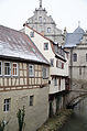
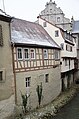
The ensemble encompasses the city within its 16th century walling, including the Breitbach and its right-hand buildings. The ground plan reveals the late urbanization: a main axis is missing, the plan structure is supported by the square-like fork in the streets to Ochsenfurt and Enheim (Ochsenfurter Strasse and Marktstrasse), in which the core of the settlement can be assumed; The south-eastern part of the village is probably attributable to a later development, which is built up like a ladder between the parallel lines of Schuster- and Pfarrgasse. A peculiarity is the road to Obernbreit , which separates from the Main-Uferstraße in front of the main gate and follows the course of the Breitbach outside the wall. The various development components condense into an urban structure with an unmistakable character. From the second half of the 16th century, the time of the expansion into a stately residence, the sovereign buildings committed to the late Renaissance date : the castle, the town hall and the fortifications of the city fortifications. The palace, a broad, simple gabled house, dominates the square palace square, to which the parish church, which became Lutheran in the course of the consolidation of power and which is still medieval in structure, appears loosely; the fork of Ochsenfurterstrasse and Marktstrasse as well as the entrance to the town from the Main are characterized by the building group of town hall and main gate, two connected buildings in unplastered quarry stone masonry with rich gables of the late renaissance. Boundaries: Maintor - Bachgasse - rear property boundaries of the property Bachgasse 3–41 - Breitbach - Fleischmannstraße - train of the city wall from Flurerturm to Bahnhofstraße - Schiller-Allee - Steingraben - Am Graben. File number: E-6-75-147-1.
Ensemble Mainstrasse
The main front along the Uferstraße to Kitzingen is not part of the old town, but an extension of the first half of the 19th century. The row of houses is essentially characterized by Biedermeier buildings in the limestone stone construction typical of the landscape. Boundary: Mainstrasse 2-60 (even numbers). File number: E-6-75-147-2.
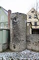
City fortifications Marktbreit
Parts of the city wall and some round towers have been preserved from the city fortifications laid out in 1529–1550. File number: D-6-75-147-1. In the following, the preserved objects of the city fortifications are listed clockwise starting with the only preserved city gate, the Maintor. photos
| location | object | description | File no. | image |
|---|---|---|---|---|
| Marktstrasse 2 ( location ) |
Maintor | City gate, so-called Maintor, two-storey solid construction with gate passage and volute gables, Renaissance building, 1600, renewed in 1946/47 | D-6-75-147-48 |
 more pictures |
Northern city wall line along the Breitbach:
- Marktstrasse 1 ( location ): city wall, included in residential building, 16th century
- Marktstraße 3 ( location ): city wall, included in residential building, 16th century
- Marktstrasse 5 ( location ): city wall, included in residential building, 16th century
- Schustergasse 1 ( location ): city wall, included in residential building, 16th century
- Schustergasse 5 ( location ): city wall, included in residential building, 16th century
- Schustergasse 7 ( location ): city wall, included in residential building, 16th century
- Schustergasse 9 ( location ): city wall, included in residential building, 16th century
- Schustergasse 11 ( location ): city wall, included in residential building, 16th century
- Schustergasse 13 ( location ): city wall, included in residential building, 16th century
- Schustergasse 15 ( location ): city wall, included in residential building, 16th century
- Schustergasse 17 ( location ): wall tower, round fortification tower, 1529/50
- Schustergasse 19 ( location ): city wall, included in residential building, 16th century
- Schustergasse 21, 23 ( location ): city wall, included in residential building, 16th century
- Schustergasse 25 ( location ): city wall, included in residential building, 16th century
In Schustergasse 27 and 29, the city wall is built into the residential buildings and is not visible from the outside. The wall is broken to the east.
- Schustergasse 33 ( location ): city wall, included in residential building, 16th century
- Schustergasse 35 ( location ): city wall, included in residential building, 16th century
- Schustergasse 37 ( location ): city wall, included in residential building, 16th century
- Schustergasse 39 ( location ): city wall, included in residential building, 16th century
- Fleischmannstraße 2 ( location ): So-called White Tower, round fortification tower with a hooded roof, 1529/50, raised in 1601
City wall Marktstrasse 1, field side
City wall Marktstraße 3, field side

City wall Marktstrasse 5, field side

City wall Schustergasse 1, field side

City wall Schustergasse 5, field side
City wall Schustergasse 7, 9, field side

City wall Schustergasse 11, field side

City wall Schustergasse 13, field side

City wall Schustergasse 15, field side
City wall Schustergasse 17, field side

Wall tower Schustergasse 17, field side
more pictures
White tower
more pictures


South-eastern city wall line along Rosmaringasse:
- Untere Rosmaringasse 1 ( location ): city wall, included in residential building, 16th century
- Untere Rosmaringasse 3 ( location ): city wall, included in residential building, 16th century
- Untere Rosmaringasse 5 ( location ): city wall, included in residential building, 16th century
- Untere Rosmaringasse 7 ( location ): wall tower, remains of a round wall tower, converted into a residential building
- Untere Rosmaringasse 7 ( location ): city wall, included in residential building, 16th century
The wall between Untere Rosmaringasse and Obere Rosmaringasse is broken through.
- Obere Rosmaringasse 1 ( location ): So-called Flurersturm, round fortification tower with pointed helmet, 1529/50
- Obere Rosmaringasse 1 ( location ): City wall, along the street, city wall used as a hillside retaining wall
- Obere Rosmaringasse 3 ( location ): city wall, included in residential building, 16th century
- Untere Rosmaringasse 3 ( location ): city wall, included in residential building, 16th century
- Untere Rosmaringasse 5 ( location ): city wall, included in residential building, 16th century
- Untere Rosmaringasse 7 ( location ): city wall, included in residential building, 16th century
- Bahnhofstrasse 5a ( location ): city wall, 16th century
City wall Untere Rosmaringasse 3, field side

Untere Rosmaringasse 7, field side
more pictures
Hall storm
more pictures
City wall Obere Rosmaringasse 3, field side
City wall Obere Rosmaringasse 5, field side

City wall Obere Rosmaringasse 7, field side

City wall Bahnhofstrasse 5a


Southwest city wall line west of the breakthrough on Bahnhofstrasse along Schillerallee and Steingraben:
- Am Stegturm 3 ( location ): city wall, 16th century
- Am Stegturm 5 ( location ): So-called Stegturm, round fortification tower with half-timbered tower and pointed helmet, 1559
- Am Stegturm 9 ( location ): city wall, 16th century
- Am Stegturm 11 ( location ): city wall, 16th century
- Am Stegturm 13 ( location ): So-called Fallmeister tower , round fortification tower with half-timbered tower and pointed helmet, 1566
- Schillerallee 3 ( location ): city wall, 16th century
- Schillerallee 1 ( location ): So-called Henkersturm, rounded corner tower, 1529/60

City wall Am Stegturm 1, 3, field side

Stegturm
more pictures
City wall Am Stegturm 7, 9, field side

City wall Am Stegturm 11, 9, 7, field side

Fallmeister tower
more pictures
Executioner storm
more pictures


Western wall move north of the Henkersturm:
- Steingraben ( location ): city wall, remains along the street, 16th century
To the north of Steingraben 4, the wall has been torn down to the middle of the Am Graben street.
- Ochsenfurter Straße 12 ( location ): city wall, 16th century
- Ochsenfurter Straße 10 ( location ): city wall, 16th century
- Ochsenfurter Straße 10 ( location ): wall tower, round fortification tower
- Ochsenfurter Straße 8 ( location ): city wall, 16th century
- Ochsenfurter Straße 6 ( location ): city wall, 16th century
The wall up to the Black Tower has not been preserved.
- Ochsenfurter Straße 10 ( location ): Black Tower, round fortification tower, adjacent to the town hall, 16th century
City wall stone ditch
City wall stone ditch

City wall and wall tower Ochsenfurter Straße 10
more pictures
City wall and wall tower Ochsenfurter Straße 10
more pictures
City wall Ochsenfurter Strasse 8

City wall Ochsenfurter Strasse 6

Black tower
more pictures
Main gate and town hall


Architectural monuments according to districts
Market wide
In the old town of Marktbreit there are two pictures of squares and streets of particular importance.
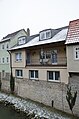
Bachgasse
The Bachgasse runs as a road connection running outside the wall to Obernbreit / Uffenheim, starting on the outside of the main gate, along the Breitbach. The street and the course of the stream form an inner space that is delimited on the one hand by the buildings on the Bachgasse itself and on the other hand by the backs of the houses on Schustergasse, which sit on the remains of the city wall and lie directly on the water. The view to the west culminates in the group of buildings of the Maintor and the adjacent half-timbered house at Bachstrasse 2, which protrudes several times over the course of the stream. Boundary: Bachgasse 1–41.
| location | object | description | File no. | image |
|---|---|---|---|---|
| Bachgasse 2 ( location ) |
Former trading house, now a local museum | Two-storey eaves side building with a steep pitched roof, half-timbered, in the core 17th century, inscribed "1774" | D-6-75-147-7 |
 more pictures |
| Bachgasse 3 ( location ) |
Residential building | Three-storey corner building with hipped roof and protruding, plastered half-timbered upper storeys, marked "1788" | D-6-75-147-8 |
 more pictures |
| Bachgasse 7 ( location ) |
Residential building | Three-storey eaves side building with a gable roof, the core of the gable house around 1700, heightened around 1900 | D-6-75-147-139 |
 more pictures |
| Bachgasse 11 ( location ) |
Residential building | Two-storey gable building with half-timbered upper storey, 18th century | D-6-75-147-10 |
 more pictures |
| Bachgasse 15 ( location ) |
Former forge | Single-storey gable building, plastered half-timbering, 18th century | D-6-75-147-11 |
 more pictures |
| Bachgasse 19 ( location ) |
Residential building | Two-storey gable building, upper floor half-timbered, 18th century | D-6-75-147-12 |
 more pictures |
| Bachgasse 23 ( location ) |
Residential building | Two-storey gable building, half-timbered upper storey, 18th century | D-6-75-147-13 |
 more pictures |
| Bachgasse 23 ( location ) |
Residential building | Side gate access | D-6-75-147-13 |
 more pictures |
Market street
The lower part of Marktstrasse widens as it comes from the Maintor, at the fork in the road to Ochsenfurt and the junction from Schustergasse to a triangular square. Monumental buildings from the heyday of the city pile up here, which, in conjunction with half-timbered houses of an old Franconian character, give the small space a special character and high picturesque value. The building group of Maintor and Town Hall completes the space to the north-west with its strict, late Renaissance architecture, which is animated by rich gable formations. The eastern confluence of Schustergasse is flanked by two patrician houses in the forms of the Würzburg Baroque of the early 18th century, whose polygonal corner oriels correspond to each other like twins. The wide gable building of the Löwen inn finally dominates the west side of the square at the fork in the road to Ochsenfurt. The components of self-administration (town hall), trade (patrician houses) and through traffic (inn) that are shown here characterize the square as a bourgeois center, in contrast to the castle square, which has a sovereign character (castle, church). Boundary: Marktstrasse 1–6, 8, 10, Schustergasse 2.
| location | object | description | File no. | image |
|---|---|---|---|---|
| Marktstrasse 1 ( location ) |
Residential building | Three-story narrow gable building, half-timbered, 17th / 18th centuries century | D-6-75-147-47 |
 more pictures |
| Marktstrasse 3 ( location ) |
Residential and commercial building | Two-storey eaves side building with roof bay window, plastered half-timbering, 18th century | D-6-75-147-49 |
 more pictures |
| Marktstrasse 4 ( location ) |
town hall | Three-storey natural stone building with richly structured gables, Renaissance building, by Hans Kesenbrod, 1579/81 | D-6-75-147-50 |
 more pictures |
| Marktstrasse 5 ( location ) |
Bürgerhaus, so-called Haus zur Groe | Two-storey solid building with rich baroque facade and corner bay window, inscribed "1725" | D-6-75-147-51 |
 more pictures |
| Marktstrasse 8 ( location ) |
Gasthaus Löwen | Two-storey wing building with half-timbered upper storey, in the core 16th century, inscribed "1382" inside and "1739" | D-6-75-147-52 |
 more pictures |
| Marktstrasse 10 ( location ) |
Residential and commercial building | Two-storey corner building with mansard roof, upper floor plastered half-timbering, 18th century | D-6-75-147-53 |
 more pictures |
| Marktstrasse 12 ( location ) |
Residential and commercial building | Two-storey brick building with volute gable, 1903 | D-6-75-147-54 |
 more pictures |
| Marktstrasse 12, back to Plochmanngasse ( location ) |
Residential building | Two-story half-hipped roof house with plastered half-timbered upper floor, late 18th century | D-6-75-147-54 |
 more pictures |
| Marktstrasse 14 ( location ) |
Residential and commercial building | Three-storey mansard roof house with stucco facade, 18th century | D-6-75-147-55 |
 more pictures |
| Marktstrasse 14, backwards to Plochmanngasse ( location ) |
Residential building | Three-storey mansard hipped roof house, 18th century | D-6-75-147-55 | |
| Schustergasse 2 ( location ) |
Former trading house | Three-storey mansard hipped roof building, richly decorated baroque facade with corner bay window, by Samson Wertheimer, by Joseph Greising, inscribed "1719" and "1789" | D-6-75-147-97 |
 more pictures |
Rest of the city center
| location | object | description | File no. | image |
|---|---|---|---|---|
| Adam-Fuchs-Strasse 2 ( location ) |
Former warehouse, now town hall | Two-storey plastered building with hipped roof, largely renovated in 1754, 1951 | D-6-75-147-4 |
 more pictures |
| Adam-Fuchs-Straße 3 ( location ) |
Former garden pavilion | Two-storey mansard hipped roof building, plastered framework, inscribed "1746" | D-6-75-147-2 |
 more pictures |
| Adam-Fuchs-Strasse 4 ( location ) |
Main crane | Bossed round building with conical roof, sandstone, by Prince Johann I zu Schwarzenberg, by master mason Johannes Michel, rebuilt in 1774 | D-6-75-147-3 |
 more pictures |
| Adam-Fuchs-Straße 12 ( location ) |
Former slaughterhouse | Single-storey three-wing natural stone building with a gable roof, classifying, 1918 | D-6-75-147-141 |
 more pictures |
| Am Graben 2 ( location ) |
Garden shed | Two-storey plastered building with a mansard hipped roof, 18th century | D-6-75-147-5 |
 more pictures |
| Bahnhofplatz 4 ( location ) |
railway station | Three-storey sandstone block building with a hipped roof and short side wings, with a wooden platform roof, around 1865 | D-6-75-147-15 |
 more pictures |
| Bahnhofstrasse 2 ( location ) |
Residential building | Two-storey gable building with half-timbered upper storey and arched gate entrance, 17th / 18th centuries century | D-6-75-147-16 |
 more pictures |
| Bahnhofstrasse 5 ( location ) |
Archway at the garden house | Sandstone, formerly marked "1770." | D-6-75-147-17 |
 more pictures |
| Bahnhofstrasse 5a ( location ) |
Catholic parish church of St. Ludwig | Single-aisle hall building with west tower, in romanizing forms, by Andreas Deppisch 1846; with equipment | D-6-75-147-18 |
 more pictures |
| Bahnhofstrasse 6 ( location ) |
Residential building | Two-storey half-hipped roof building with half-timbered upper storey, labeled "1596" | D-6-75-147-19 |
 more pictures |
| Bahnhofstrasse 6, in the courtyard ( location ) |
Stone relief | With crucifixion group, 15th century | D-6-75-147-19 | |
| Bahnhofstrasse 8 ( location ) |
The year 1566 above the garage door | D-6-75-147-20 | ||
| Bahnhofstrasse 9 ( location ) |
Inn | Two-storey plastered building with mansard hipped roof, labeled "1785" and "1810" | D-6-75-147-21 |
 more pictures |
| Bahnhofstrasse 13 ( location ) |
Former inn | Three-storey eaves side building with half hips and baroque frames, labeled "1787" | D-6-75-147-22 |
 more pictures |
| Bahnhofstrasse 17; Bahnhofstrasse 19 ( location ) |
Duplex | Two-storey mansard roof building, 18th / 19th centuries century | D-6-75-147-23 |
 more pictures |
| Bahnhofstrasse 21 ( location ) |
Residential building | Two-storey solid construction with a mansard roof and stone structure, marked "1797" | D-6-75-147-24 |
 more pictures |
| Bernhard-Fischer-Strasse 1 ( location ) |
Residential building | Two-storey corner building with a mansard hipped roof, 18th century | D-6-75-147-25 |
 more pictures |
| Bernhard-Fischer-Strasse 3 ( location ) |
Community center | Two-storey solid building with a mansard roof, marked "1785" | D-6-75-147-26 |
 more pictures |
| Bernhard-Fischer-Strasse 5 ( location ) |
Evangelical parish hall | Two-storey mansard roof building with central projection, 18th century, renovated in 1955 | D-6-75-147-27 |
 more pictures |
| Bernhard-Fischer-Strasse 7 ( location ) |
Residential building | Two-storey mansard roof with half-hipped roof, 18th / 19th centuries century | D-6-75-147-28 |
 more pictures |
| Buheleite 10 ( location ) |
Coat of arms stone | By 1610 | D-6-75-147-29 | |
| Buheleite 15 ( location ) |
Residential building | Single-storey hipped mansard roof, first half of the 19th century | D-6-75-147-30 |
 more pictures |
| Buheleite 19 ( location ) |
Residential building | Two-storey eaves side building with mansard roof, marked "1835" | D-6-75-147-31 |
 more pictures |
| Felsenkellerweg 7 ( location ) |
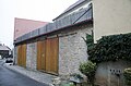
Rock cellar | With cellar house and tree-lined terrace with retaining wall, 18./19. century | D-6-75-147-144 | |
| Fleischmannstrasse 4 ( location ) |
villa | Two-storey limestone building with a gable roof and sandstone structures, around 1870/80 | D-6-75-147-33 |
 more pictures |
| Kapellenberg ( location ) |
St. Moritz Chapel | Gothic hall building with five-eighth end and roof turret, mentioned in 1324, enclosing walls from 1510, renovated in 1844 | D-6-75-147-121 |
 more pictures |
| Kapellensteige 1 ( location ) |
Former Princely Schwarzenberg Brewery | Two-storey hipped mansard roof, in the core 1670 | D-6-75-147-34 |
 more pictures |
| Kapellensteige 1 ( location ) |
Rear building | High quarry stone building with an irregular roof area, 18th / 19th centuries century | D-6-75-147-34 |
 more pictures |
| Lange Gasse 5 ( location ) |
Residential building | Two-storey corner building with a mansard hipped roof and drilled window frames, 18th century | D-6-75-147-35 |
 more pictures |
| Lange Gasse 6 ( location ) |
Residential building | Three-storey eaves side building with drilled door frame, 18th century | D-6-75-147-36 |
 more pictures |
| Lange Gasse 7 ( location ) |
Residential building | Three-storey eaves side building with half-timbered upper storey, 18th century | D-6-75-147-37 |
 more pictures |
| Lange Gasse 8 ( location ) |
Residential building | Three-storey solid building with hipped roof, classicistic, around 1800 | D-6-75-147-38 |
 more pictures |
| Mainstrasse 8 ( location ) |
Inn | Three-storey gable building, marked "1568" | D-6-75-147-39 |
 more pictures |
| Mainstrasse 14 ( location ) |
Residential building | Two-storey sandstone block building with hipped roof, round arch style, around 1840/50 | D-6-75-147-40 |
 more pictures |
| Mainstrasse 28 ( location ) |
window | Sandstone walls, inscribed "1761" | D-6-75-147-41 |
 more pictures |
| Mainstrasse 36 ( location ) |
Residential building | Two-storey plastered building with mansard hipped roof, marked "1886" | D-6-75-147-42 |
 more pictures |
| Mainstrasse 40 ( location ) |
Residential building | Two-storey eaves side building with mansard hipped roof, early 19th century | D-6-75-147-44 |
 more pictures |
| Mainstrasse 42 ( location ) |
Residential building | Two-storey eaves side building with half-hipped roof, quarry stone masonry, inscribed "1846" | D-6-75-147-45 |
 more pictures |
| Mainstrasse 50 ( location ) |
Residential building | Two-storey gable building, quarry stone masonry, inscribed "1853" | D-6-75-147-46 |
 more pictures |
| Neue Obernbreiter Straße 2 ( location ) |
Garden shed | Two-storey crenellated tower, neo-Gothic, second half of the 19th century | D-6-75-147-56 | |
| Obere Rosmaringasse 2 ( location ) |
Residential building | Three-storey saddle roof building, upper storey plastered half-timbering, 17th century, over an older core | D-6-75-147-58 | |
| Ochsenfurter Straße 1 ( location ) |
Residential and commercial building | Two-storey corner house with a mansard hipped roof, upper floor plastered half-timbering, late 18th century | D-6-75-147-60 |
 more pictures |
| Ochsenfurter Straße 2 ( location ) |
Residential building | Three-story hipped roof building, early 19th century | D-6-75-147-140 |
 more pictures |
| Ochsenfurter Straße 2, in the basement area ( location ) |
Mikveh | 19th century | D-6-75-147-140 | |
| Ochsenfurter Straße 3 ( location ) |
Residential and commercial building | Two-storey saddle roof building with plastered half-timbered upper storey, gable slated, 1626 | D-6-75-147-61 |
 more pictures |
| Ochsenfurter Straße 4 ( location ) |
Residential and commercial building | Two-storey saddle roof building, truss plastered in the gable, 18th / 19th centuries Century, ground floor conversion marked "1925" | D-6-75-147-62 |
 more pictures |
| Ochsenfurter Straße 8 ( location ) |
inscription | "JC Grötsch, 1827" | D-6-75-147-64 |
 more pictures |
| Ochsenfurter Straße 9 ( location ) |
Gabled house | Two-storey half-timbered building, plastered, 17th century | D-6-75-147-65 |
 more pictures |
| Ochsenfurter Straße 10 ( location ) |
Residential building | Two-storey eaves side building with plastered half-timbered upper storey, 18th / 19th centuries century | D-6-75-147-66 |
 more pictures |
| Ochsenfurter Straße 12 ( location ) |
Gabled house | Two-storey solid building with half-timbered upper storey, labeled "1572" | D-6-75-147-67 |
 more pictures |
| Ochsenfurter Straße 30 ( location ) |
Residential building | Three-storey natural stone building with hipped roof, classicist structure, labeled "1845" | D-6-75-147-68 |
 more pictures |
| Pfarrgasse 1 ( location ) |
Residential building | Two-storey hipped roof building, marked "1717–1719" | D-6-75-147-69 |
 more pictures |
| Pfarrgasse 2 ( location ) |
Evangelical Lutheran Parish Church of St. Nikolai | Hall building with choir tower and polygonal apse, tower basement 14th century, choir 15th century, nave 1438; with equipment | D-6-75-147-70 |
 more pictures |
| Pfarrgasse 3 ( location ) |
Residential building | Two-storey corner building with half-timbered upper storey, marked "1559", renewed | D-6-75-147-71 |
 more pictures |
| Pfarrgasse 6 ( location ) |
Stately gabled house | With projecting half-timbered upper storeys, marked "1583" | D-6-75-147-73 |
 more pictures |
| Pfarrgasse 7 ( location ) |
Residential building | Two-storey eaves side building with half-timbered upper storey, marked "1836" | D-6-75-147-72 |
 more pictures |
| Pfarrgasse 8 ( location ) |
Residential building | Three-storey gabled house with mansard roof, plastered half-timbered upper storeys, inscribed "1789" | D-6-75-147-74 |
 more pictures |
| Pfarrgasse 9 ( location ) |
Former Protestant school | Two-storey stone building with hipped roof, 1879 | D-6-75-147-75 |
 more pictures |
| Pfarrgasse 11 ( location ) |
Residential building | Two-storey plastered building with hipped roof and drilled window frames, labeled “1704”, redesigned around 1800 | D-6-75-147-76 |
 more pictures |
| Pfarrgasse 12 ( location ) |
Evangelical Lutheran rectory | Two-storey solid building with hipped roof, marked "1710/11" | D-6-75-147-77 |
 more pictures |
| Pfarrgasse 12 ( location ) |
Gate entrance | Sandstone, 17th century | D-6-75-147-77 |
 more pictures |
| Pförtleinsgasse 2 ( location ) |
Residential building | Two-storey gable building, upper floor half-timbered, plastered, 18th century | D-6-75-147-78 |
 more pictures |
| Pförtleinsgasse 4 ( location ) |
Residential building | Two-storey gable building, upper floor half-timbered, plastered, with drilled door frame, inscribed "1710" | D-6-75-147-79 |
 more pictures |
| Pförtleinsgasse 8 ( location ) |
Residential building | Gabled double house with plastered half-timbered upper floors, 17th / 18th centuries century | D-6-75-147-81 |
 more pictures |
| Pförtleinsgasse 9 ( location ) |
Residential building | Two-storey plastered building with mansard hipped roof and drilled frames, marked "1746" | D-6-75-147-80 |
 more pictures |
| Pförtleinsgasse 10 ( location ) |
Former synagogue and Jewish school | Three-storey hipped roof building with mikveh, 1717, redesigned and extended after 1945 | D-6-75-147-136 |
 more pictures |
| Pförtleinsgasse 10 ( location ) |
Jewish war memorial | around 1920 | D-6-75-147-136 |
 more pictures |
| Plochmanngasse ( ) |
See Marktstrasse 12, 14 | not re-qualified, not mapped in the Bavarian Monument Atlas | D-6-75-147-82 | |
| Schillerallee 2 ( location ) |
graveyard | With tombstones from the 16th to mid-20th centuries, laid out in 1566, expanded in 1618 and 1835 | D-6-75-147-88 |
 more pictures |
| Schillerallee 2 ( location ) |
Cemetery chapel | Rectangular hall building with a gable roof, inscribed "1586", changed in 1870, with a stone former pulpit, around 1600 | D-6-75-147-88 |
 more pictures |
| Schillerallee 2 ( location ) |
Cemetery, wooden arbors open at the sides | With a gable roof on the eastern wall of the cemetery | D-6-75-147-88 |
more pictures |
| Schillerallee 2 ( location ) |
Cemetery, crypt, so-called Tauber-Lambert pavilion | Around 1720 | D-6-75-147-88 |
 more pictures |
| Schillerallee 2 ( location ) |
Cemetery, cemetery wall with north and east portal | 16th Century | D-6-75-147-88 |
 more pictures |
| Schillerallee 2 ( location ) |
Cemetery, gate | Wrought iron, 1883 | D-6-75-147-88 |
 more pictures |
| Schloßplatz 1 ( location ) |
Residential building | Three-storey solid building with hipped roof, with arched gate, marked "1814", renewed | D-6-75-147-90 |
 more pictures |
| Schloßplatz 3 ( location ) |
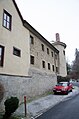
Former castle of the Counts of Seinsheim | Three-storey solid construction with volute gables and square stair tower, around 1580 | D-6-75-147-91 |
 more pictures |
| Schulgasse 1; Schustergasse 8 ( location ) |
Residential and commercial building | Three-storey eaves side building with mansard roof, 18th / 19th centuries century | D-6-75-147-103 |
 more pictures |
| Schulgasse 2 ( location ) |
Gabled house | Upper floor half-timbered plastered, 17./18. century | D-6-75-147-92 |
 more pictures |
| Schulgasse 5 ( location ) |
Residential building | Two-storey eaves side building with baroque door, marked "1708" | D-6-75-147-93 |
 more pictures |
| Schulgasse 11 ( location ) |
Residential building | Two-storey plastered building with a mansard roof, labeled "1808", over the older core | D-6-75-147-94 |
 more pictures |
| Schulgasse 15 ( location ) |
Residential building | Two-storey gable building with half-timbered upper storey, 16./17. century | D-6-75-147-95 |
 more pictures |
| Schustergasse 1 ( location ) |
Residential and commercial building | Two-storey gable structure, upper storey plastered half-timbering, 18th century | D-6-75-147-96 |
 more pictures |
| Schustergasse 4 ( location ) |
Residential and commercial building | Three-storey gable building with a gable roof, 18th century | D-6-75-147-99 |
 more pictures |
| Schustergasse 5 ( location ) |
Residential building | Two-storey eaves side building, upper storey plastered half-timbering, 18th century | D-6-75-147-100 |
 more pictures |
| Schustergasse 6 ( location ) |
Residential and commercial building | Two-storey gable building, upper floor plastered half-timbering, 17th / 18th centuries century | D-6-75-147-101 |
 more pictures |
| Schustergasse 9 ( location ) |
Residential and commercial building | Two-storey gable building with mansard roof, gable plastered half-timbering, 18th century | D-6-75-147-104 |
 more pictures |
| Schustergasse 10 ( location ) |
Residential and commercial building | Two-storey hipped roof building with gable facade, classicistic, 1830/40, over an older core | D-6-75-147-105 |
 more pictures |
| Schustergasse 11 ( location ) |
Residential and commercial building | Two-storey eaves side building, upper storey plastered half-timbering, 18th century | D-6-75-147-106 |
 more pictures |
| Schustergasse 20 ( location ) |
Community center | Two-storey corner building with half-timbered upper storey and portico, 1603 | D-6-75-147-110 |
 more pictures |
| Schustergasse 21 ( location ) |
Door frames | Sandstone, inscribed "1718" | D-6-75-147-111 | |
| Schustergasse 21, 23 ( location ) |
Door frames | Sandstone, probably 1718 | D-6-75-147-112 |
 more pictures |
| Schustergasse 25 ( location ) |
Door frames | Sandstone, inscribed "1744" | D-6-75-147-113 |
 more pictures |
| Schustergasse 35 ( location ) |
Former craftsman's house | Two-storey eaves side building with mansard roof and drilled window frames, 18th century | D-6-75-147-116 |
 more pictures |
| Schustergasse 39 ( location ) |
Residential building | Two-storey eaves side building, in the core 17th / 18th century | D-6-75-147-118 |
 more pictures |
Gnodstadt
| location | object | description | File no. | image |
|---|---|---|---|---|
| At Frauenberg 2; Am Frauenberg 4 ( location ) |
Residential building | Two-storey saddle roof building with stepped gable, sandstone cuboid, 1889 | D-6-75-147-137 | |
| At Frauenberg 2; Am Frauenberg 4 ( location ) |
enclosure | Natural stone masonry | D-6-75-147-137 | |
| At Frauenberg 2; Am Frauenberg 4 ( location ) |
barn | Two-storey solid construction with a gable roof | D-6-75-147-137 | |
| Channs 3 ( location ) |
Residential stable house | Single-storey plastered half-timbered building with a gable roof, end of the 18th century | D-6-75-147-122 |
 more pictures |
| Channs 5 ( location ) |
Farmhouse | Two-storey sandstone block construction with a crooked hip roof, around 1860 | D-6-75-147-123 |
 more pictures |
| Channs 15 ( location ) |
Farmhouse | Two-storey sandstone cuboid building with a crooked hip roof, inscribed "1856" | D-6-75-147-124 |
 more pictures |
| Dr.-Conrad-Strasse 1 ( location ) |
Courtyard enclosure | With gate pillars made of natural stone, wrought iron gate and grille, first half of the 19th century | D-6-75-147-125 |
 more pictures |
| Hauptstrasse 6 ( location ) |
Farmhouse | Two-storey with half-timbered upper storey and half hip, around 1800 | D-6-75-147-126 |
 more pictures |
| Hauptstrasse 8 ( location ) |
Farmhouse | Two-storey saddle roof construction, in parts with half-timbered upper storey and half-timbered gable, 17th / 18th centuries century | D-6-75-147-127 |
 more pictures |
| Hauptstrasse 8 ( location ) |
Gate post and gate | Sandstone, inscribed "1820" | D-6-75-147-127 |
 more pictures |
| Hauptstrasse 10 ( location ) |
Farmhouse | Two-storey sandstone cuboid building with a crooked hip roof, labeled "1849" | D-6-75-147-128 |
 more pictures |
| Hauptstrasse 18 ( location ) |
Farmhouse | Gable construction with half-timbered upper floor and outside staircase, basement sandstone cuboid with round arched gate, end of the 18th century | D-6-75-147-129 |
 more pictures |
| Way of the Cross ( location ) |
Wayside shrine | With crucifixion relief, sandstone, inscribed "1598" | D-6-75-147-134 | |
| Near Pfarrer-Geyer-Straße ( location ) |
graveyard | Former fortified complex with tombs from the 18th, 19th and early 20th centuries | D-6-75-147-133 |
 more pictures |
| Near Pfarrer-Geyer-Straße ( location ) |
Cemetery wall | Natural stone masonry, partly medieval | D-6-75-147-133 |
 more pictures |
| Pfarrer-Geyer-Straße 2 ( location ) |
Former office building | Two-storey hipped roof building, marked "1731" | D-6-75-147-130 |
 more pictures |
| Pfarrer-Geyer-Straße 4 ( location ) |
Rectory | Two-storey half-hipped roof building, around 1820 | D-6-75-147-131 |
 more pictures |
| Pfarrer-Geyer-Straße 19 ( location ) |
Evangelical Lutheran Parish Church | Hall building with slightly retracted polygonal choir, 13th century tower with helmet from 1577, nave Gothic core, modified in the 18th century, late Gothic choir; with equipment | D-6-75-147-132 |
 more pictures |
| Würzburg-Ansbach, B 13 ( location ) |
Toll pyramid | Obelisk-like border monument, erected on the occasion of the road construction by Margrave Friedrich Karl Alexander von Brandenburg, sandstone, 1766/73, badly damaged by a traffic accident in 2010, rebuilt in 2012 east of the street at the same height | D-6-75-147-135 |
 more pictures |
See also
Remarks
- ↑ This list may not correspond to the current status of the official list of monuments. The latter can be viewed on the Internet as a PDF using the link given under web links and is also mapped in the Bavarian Monument Atlas . Even these representations, although they are updated daily by the Bavarian State Office for Monument Preservation , do not always and everywhere reflect the current status. Therefore, the presence or absence of an object in this list or in the Bavarian Monument Atlas does not guarantee that it is currently a registered monument or not. The Bavarian List of Monuments is also an information directory. The monument property - and thus the legal protection - is defined in Art. 1 of the Bavarian Monument Protection Act (BayDSchG) and does not depend on the mapping in the monument atlas or the entry in the Bavarian monument list. Objects that are not listed in the Bavarian Monument List can also be monuments if they meet the criteria according to Art. 1 BayDSchG. Early involvement of the Bavarian State Office for Monument Preservation according to Art. 6 BayDSchG is therefore necessary in all projects.
literature
- Denis André Chevalley: Lower Franconia . Ed .: Michael Petzet , Bavarian State Office for the Preservation of Monuments (= Monuments in Bavaria . Volume VI ). Oldenbourg, Munich 1985, ISBN 3-486-52397-X .
Web links
- Bavarian Monument Atlas (cartographic representation of the Bavarian architectural and ground monuments by the Bavarian State Office for Monument Preservation (BLfD) )
- List of monuments for Marktbreit (PDF) at the Bavarian State Office for Monument Preservation

Abtswind | Albertshofen | Biebelried | Buchbrunn | Castell | Dettelbach | Hostage wind | Großlangheim | Iphofen | Kitzingen | Kleinlangheim | Mainbernheim | Mainstockheim | Einersheim Market | Market wide | Marktsteft | Martinsheim | Nordheim am Main | Obernbreit | Prichsenstadt | Rödelsee | Rüdenhausen | Schwarzach am Main | Segnitz | Home of being | Sommerach | Sulzfeld am Main | Volkach | Wiesenbronn | Wiesentheid | Willanzheim