
Obernbreit
| coat of arms | Germany map | |
|---|---|---|

|
Coordinates: 49 ° 39 ' N , 10 ° 10' E |
|
| Basic data | ||
| State : | Bavaria | |
| Administrative region : | Lower Franconia | |
| County : | Kitzingen | |
| Management Community : | Market wide | |
| Height : | 198 m above sea level NHN | |
| Area : | 9.84 km 2 | |
| Residents: | 1720 (Dec. 31, 2019) | |
| Population density : | 175 inhabitants per km 2 | |
| Postal code : | 97342 | |
| Area code : | 09332 | |
| License plate : | KT | |
| Community key : | 09 6 75 156 | |
| Market structure: | 1 district | |
| Association administration address: | Marktstrasse 4 97340 Marktbreit |
|
| Website : | ||
| Mayoress : | Susanne Knof ( Free Voters ) | |
| Location of the Obernbreit market in the Kitzingen district | ||
  |
||

Obernbreit is a market in the Lower Franconian district of Kitzingen and a member of the Marktbreit administrative association .
geography
Obernbreit is in the planning region of Würzburg (Bavarian planning region 2).
There is only the district Obernbreit.
Neighboring communities are (starting from the north clockwise) Marktsteft , Seinsheim , Martinsheim and Marktbreit .
Obernbreit is naturally located in the Ifftal area , which is characterized by deep valleys.
history
Until the church is planted
Finds from the Neolithic age indicate an early settlement.
The place itself is mentioned in the deed of division of Count Heinrich II. And Hermann II. Zu Castell for the first time in 1266 as due ville Broite et Broite . A little later, the two villages were given the names broite superior (Obernbreit) and broite inferior to distinguish them . The later Marktbreit developed from Niedernbreit. At the end of the 13th century, the gentlemen von Hohenlohe-Brauneck appear as owners of broite superior .
In 1448 the place came to Margrave Albrecht Achilles of Brandenburg through purchase together with five other “ Maindörfern ” from Hohenlohe possession. A four-day siege, the capture and looting by the Würzburg troops of Bishop Johann III. von Grumbach had to endure the First Markgräfler War in 1448. The margraves remained the dominant feudal givers and introduced the Reformation in 1528. During the Thirty Years' War the place burned down almost completely in 1634. After the Peace of Westphalia, Oberbreit received the margravial administrative seat. From 1650 to 1730 Obernbreit remained the seat of the Oberschultheissen for the following six “main villages”: Obernbreit, Gnodstadt, Marktsteft, Sickershausen, Martinsheim and Oberickelsheim.
The former condominium location of the Principality of Ansbach , the Bishopric of Würzburg and the County of Schwarzenberg was finally completely taken over by Ansbach. The rule of the Ansbacher ended in 1791. From that year Obernbreit belonged to Prussia and from 1806 with the Principality of Bavaria. In 1810 the place came to the Grand Duchy of Würzburg during border adjustments and with it fell back to the Kingdom of Bavaria in 1814 . In the course of the administrative reforms in Bavaria, today's municipality was created with the municipal edict of 1818 .
Since the second half of the 20th century there has been a Catholic parish again in Obernbreit. With the Maria-Königin-Kirche she got her own house of worship in 1970.
Population development
| year | Residents |
|---|---|
| 1970 | 1543 inhabitants |
| 1987 | 1484 inhabitants |
| 1991 | 1615 inhabitants |
| 1995 | 1709 inhabitants |
| 2000 | 1794 inhabitants |
| 2005 | 1925 inhabitants |
| 2010 | 1746 inhabitants |
| 2015 | 1712 inhabitants |
politics
mayor
Susanne Knof (nominated by Free Voters of Bavaria and Free Voters Obernbreit) has been Mayor since May 1, 2020; it was elected on March 15, 2020 with 79.5% of the valid votes. Her predecessor was Bernhard Brückner (CSU), in office from May 1, 2002 to April 30, 2020. Brückner was the successor to Friedrich Heidecker ( SPD ).
coat of arms
|
|
Blazon : "Square of silver and black." |
| Founding of the coat of arms: Until the regional reform in 1972 , a coat of arms made of silver and red was used. It was the coat of arms of the Counts of Castell , who ruled the municipality from 1258 until 1448. This coat of arms has been proven since the 16th century. Today's coat of arms with the crossing of silver and black is the coat of arms of the Margraves of Ansbach-Bayreuth from the Hohenzollern family . Obernbreit belonged to this margraviate from 1448 to 1792. The tinging of the coat of arms was uncertain for a long time, Otto Hupp determined the colors silver and red, i.e. the colors of the Castell family. However, the municipality carries the coat of arms of the Margraves of Ansbach in the tinging silver and black. |
Culture and sights
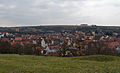
View of the village with the cemetery chapel, town hall and St. Burkard

Long side of the town hall with Breitbachbrücke

Gable side of the town hall

St. Burkard

View into the chancel

Altar of St. Burkard

pulpit

Sound cover

Baptismal font

Cemetery Church of the Holy Cross


Architectural monuments
St. Burkard
Only a few remains tell of the fortified church with cemetery. This was mentioned in a document in 1462. A previous building on the site of today's parish church St. Burkard was destroyed in 1634 during the Thirty Years' War . The church, built in 1661, was again dilapidated a short time later. Johann David Steingruber began building the current church building in 1731. The church was consecrated on November 16, 1732.
The margrave style is evident in St. Burkard . This was an expression of the Evangelical Lutheran faith. Its elements can be found here in the exterior and interior design. A two-story gallery was drawn into the rectangular hall of the nave. The furnishings, baptismal font and pulpit, moved from the previous building into the immediate vicinity of the altar.
Heilig Kreuz cemetery church
Originally, the dead were buried in the churchyard. In 1585 the cemetery was moved to the site. This year and two names are written on the lintel stone of the arched gate: "PAVLUS STRENG" and "PAULUS HEUNISCH". Little is known of previous buildings and the age of this small church in the cemetery. But there was a Holy Cross chapel as early as the 15th century.
The interior has a simple coffered ceiling and a gallery. It is simple and bright. That and the pulpit wall in the pointed arch, which blocks the view into the apse, are reminiscent of margrave style churches. The organ came on the gallery in 1908.
town hall
Inscriptions above the portal and in the gable indicate the period of construction 1609–1610. Older remains such as the margrave's coat of arms and the year 1563 come from the previous building, a Jacob's church. Hans Keesebrod from Segnitz was the builder.
The narrow side with volute gable faces the main street. On a high stone plinth, a storey up to the roof was placed alongside in a half-timbered construction. The first floor can only be reached through a covered flight of stairs.
synagogue
Local Jews appear in the sources for the first time in 1528. Their existence is also confirmed in 1531, 1534, 1558 and 1668 by issued Jewish protection letters . In 1714 and 1796, the sources speak of six local families. In 1832, 157 Jewish people lived in the village. That was 12.3 percent of the population. This number then fell continuously again. In 1910 there were still 20 Jewish people here and in 1942 the last four Jewish residents were deported to Izbica and Theresienstadt .
The community had a synagogue with a school and a ritual bath.
In 1748 a new synagogue was completed in Obernbreit and used as a religious center until the community was dissolved in 1911. After the interior furnishings were sold, the sacred building came into private ownership. Only the stone embedded in the outer wall with the relief of the Star of David reminded of the original use of the building. Pastor Walz had the Chuppastein renovated from 1996 to 1999. This stone is also known as a wedding stone . The bridegroom smashed a glass on him. With this he reminded of the destruction of the temple in Jerusalem.
After it was founded, the sponsoring and development association acquired the former synagogue Obernbreit e. V. 2005 took care of the renovation and maintenance of the former synagogue as a cultural center. The mikveh was discovered during the renovation and has already been restored.
The synagogue was located at Kirchgasse 4. It was formerly called Judengasse. On October 14, 2008, the market town council set the name for the location An der Synagoge 1 .
Economy and Infrastructure
Economy including agriculture and forestry
In 1998, according to official statistics, there were no employees at the place of work in the manufacturing sector 48 or in the trade and transport sector. In other economic sectors, 48 people were employed at the place of work subject to social security contributions. There were 597 employees at the place of residence subject to social security contributions. There was one company in the manufacturing sector and no company in the construction sector. In addition, in 1999 there were 28 farms with an agricultural area of 637 hectares, of which 545 hectares were arable land and 73 hectares were permanent green areas.
Viticulture
Obernbreit is today a wine-growing area in the Franconian wine-growing region . There is a vineyard around the village, the wine has been marketed under the name Obernbreiter Kanzel since the 1970s. Obernbreit is part of the region Main south until 2017, the wineries in area were Maindreieck summarized. The limestone soils around Obernbreit are also suitable for growing wine, as is the location in the Maingau climate zone, which is one of the warmest in Germany.
The people around Obernbreit have been growing wine since the early Middle Ages . The Franconian settlers probably brought the vine to the Main in the 7th century. In the Middle Ages, the region was part of the largest contiguous wine-growing region in the Holy Roman Empire. The people mostly operated part-time viticulture for self-sufficiency , at the same time export centers were already emerging, especially along the Main. In Obernbreit the wine was delivered to the farm in Ansbach .
After secularization , viticulture experienced a major decline at the beginning of the 19th century. Above all, locations with less favorable climatic conditions were completely abandoned. In addition, the emergence of pests such as phylloxera made cultivation difficult . At the beginning of the 1970s there were no more areas with vines around Obernbreit. The Franconian wine-growing region was not able to consolidate again until the second half of the 20th century. The use of fertilizers and improved cultivation methods had contributed to this, as had the organization in cooperatives and land consolidation in the 1980s.
The Obernbreiter corridors were cleaned up in three phases between 1982 and 1990. Today a wine festival is celebrated in the town at the beginning of July . In addition, a grape variety hiking trail runs through the vineyards above the village, which was initiated by the local viticulture association.
| Vineyard | Size 1940 | Size 1978 | Size 1993 | Compass direction | Slope | Main grape varieties | Great location |
|---|---|---|---|---|---|---|---|
| pulpit | 16 ha | 0.7 ha | 24 ha | South – Southwest | 10-15% | Müller-Thurgau , Silvaner , Bacchus | Kitzinger Councilor |
education
In 1999 the following institutions existed:
- Kindergartens: 75 kindergarten places with 55 children
Personalities
- Georg Christoph Zimmermann (1665–1744), Protestant clergyman, writer
- Johann Friedrich Salomon Luz (1744–1827), clergyman, church councilor, natural scientist
- Joseph Herzfelder (1836–1904), lawyer, poet, Goethe researcher
- Leo Benario (1875–1947), newspaper scholar in Nuremberg and 1905–1917 business editor for the Frankfurter Zeitung , was born in Obernbreit.
- Edi Hornischer (1934–2001), composer, “poet's office manager” for a law firm for 47 years, and “Friday poet” from Main Post, Schweinfurter Tagblatt and Fränkisches Volksblatt for over a quarter of a century , lived in Obernbreit for almost 50 years.
literature
- District of Kitzingen (ed.): Art and culture guide through the district of Kitzingen . 2nd Edition. Color printing Brühl, Marktbreit 1993.
- Evang. – Luth. Deanery Kitzingen (ed.): Gesegnetes Land . Paths through the Evangelical Dean's Office Kitzingen am Main. Kitzingen 2012.
- Hans Bauer: Old and new coats of arms in the Kitzingen district . In: Yearbook of the district of Kitzingen 1980. In the spell of the Schwanberg . Kitzingen 1980. pp. 53-70
- Johann Ludwig Klarmann: The Steigerwald in the past. A contribution to Franconian cultural studies . Gerolzhofen 2 1909
- Johann Kaspar Bundschuh : Oberbrait . In: Geographical Statistical-Topographical Lexicon of Franconia . tape 4 : Ni-R . Verlag der Stettinische Buchhandlung, Ulm 1801, DNB 790364301 , OCLC 833753101 , Sp. 157 ( digitized version ).
- Gottfried Stieber: Obern-Braidt . In: Historical and topographical news from the Principality of Brandenburg-Onolzbach . Johann Jacob Enderes, Schwabach 1761, p. 608-612 ( digitized version ).
Web links
- Entry on the coat of arms of Obernbreit in the database of the House of Bavarian History
Individual evidence
- ↑ "Data 2" sheet, Statistical Report A1200C 202041 Population of the municipalities, districts and administrative districts 1st quarter 2020 (population based on the 2011 census) ( help ).
- ↑ a b c d Count Alexander zu Castell: Obernbreit . In: Jesko Graf zu Dohna (Ed.): In the footsteps of the Counts of Castell . Vier Türme GmbH, Benedict Press, Münsterschwarzach 2004.
- ^ Susanna Berger: Market Obernbreit . In: District Kitzingen (ed.): Art and culture guide through the district Kitzingen . 2nd Edition. Color printing Brühl, Marktbreit 1993.
- ↑ "To the southern tip of the Main Triangle" - Tour 2 . 2. Obernbreit. In: Evang. – Luth. Deanery Kitzingen (ed.): Gesegnetes Land . Paths through the Evangelical Dean's Office Kitzingen am Main. Kitzingen 2012, p. 97 .
- ^ Bauer, Hans: Old and new coats of arms in the district of Kitzingen . P. 64
- ↑ a b c Obernbreit (VG Marktbreit, Kitzingen district) Jewish history / synagogue. January 17, 2013, accessed April 6, 2013 .
- ↑ a b Association of sponsors and sponsors of the former synagogue Obernbreit. Building. (No longer available online.) Archived from the original on January 5, 2014 ; Retrieved April 10, 2013 . Info: The archive link was inserted automatically and has not yet been checked. Please check the original and archive link according to the instructions and then remove this notice.
- ^ Ambrosi, Hans (among others): German Vinothek: Franconia . Pp. 50-52
- ↑ Obernbreit: Our vineyard , accessed on May 29, 2019.
- ^ Government of Lower Franconia: Vineyards in Bavaria broken down by area , PDF file, accessed on May 16, 2019
- ↑ Ambrosi, Hans (et al.): Deutsche Vinothek: Franken , p. 237
- ↑ Klarmann, Johann Ludwig: The Steigerwald in the past . P. 204 f.

Cities: Dettelbach | Iphofen | Kitzingen | Mainbernheim | Market wide | Marktsteft | Prichsenstadt | Volkach
Markets: Abtswind | Hostage wind | Großlangheim | Kleinlangheim | Einersheim Market | Obernbreit | Rüdenhausen | Schwarzach am Main | Home of being | Wiesentheid | Willanzheim
Municipalities: Albertshofen | Biebelried | Buchbrunn | Castell | Mainstockheim | Martinsheim | Nordheim am Main | Rödelsee | Segnitz | Sommerach | Sulzfeld am Main | Wiesenbronn