Bibart (river)
|
Bibart old name: beaver |
||
|
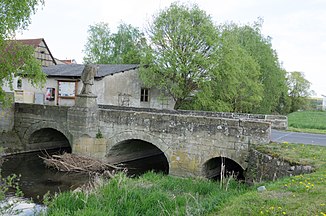
View of Bibart and Bibart Bridge in Altmannshausen (2014) |
||
| Data | ||
| Water code | DE : 242822 | |
| location | Southern Steigerwald
|
|
| River system | Rhine | |
| Drain over | Laimbach → Ehebach → Aisch → Regnitz → Main → Rhine → North Sea | |
| source | eastern Schwanberg 49 ° 43 ′ 29 ″ N , 10 ° 19 ′ 21 ″ E |
|
| Source height | 374 m above sea level NHN | |
| confluence | with the left banknote to Laimbach near Oberlaimbach Coordinates: 49 ° 38 '38 " N , 10 ° 28' 12" E 49 ° 38 '38 " N , 10 ° 28' 12" E |
|
| Mouth height | approx. 297 m above sea level NHN | |
| Height difference | approx. 77 m | |
| Bottom slope | approx. 4.6 ‰ | |
| length | 16.7 km | |
| Catchment area | approx. 66.7 km² | |
|
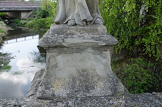
View from the Bibartbrücke in Altmannshausen to the Bibart (2014) |
||
The Bibart is a third and second order flowing water in the southern Steigerwald in the Bavarian districts of Kitzingen and Neustadt an der Aisch-Bad Windsheim . After about 17 km long, all year round water bearing on middle and lower reaches run around to the southeast it joins the left notes in Kirchdorf Oberlaimbach town Scheinfeld to Laimbach .
Surname
The name of the river was beaver until the early 19th century , which indicates that the great rodent of the same name was native there.
geography
Source and source branches
The spring and the two spring branches are not water-bearing all year round. The pouring fluctuates strongly with the seasons. In hot, dry summers, this part can also fall completely dry. The Bibart is only considered permanent from flow kilometer 3.0, the inflow of the Seewiesenbach in the Gewann Binsenschlag and other temporarily water-bearing land ditches.
course
The Bibart rises inconsistently on the saddle between the easternmost Schwanberg and Kugelspielberg in a wooded area with many burial mounds about 2.3 kilometers northwest of the parish village of Birklingen in the town of Iphofen in the Kitzingen district . It flows consistently in an approximately south-easterly direction. As soon as it leaves the forest before the church village, it is accompanied by the B 286 . It passes Birklingen on its southwest side and changes downwards over to the district of Neustadt an der Aisch-Bad Windsheim in the area of Markt Bibart and runs right past its church village Ziegenbach . After crossing a small tongue of Iphofen around its hamlet Bruckhof , the valley road continues as the B 8 from the hamlet of Enzlar von Markt Bibart . The small river runs past the hamlet of Altenspeckfeld on the left bank and then past the parish village of Altmannshausen on the same side. As the last town in the market town and the largest on the river, Markt Bibart itself is largely to the right of the Bibart. After moving to the area of the town of Scheinfeld , the Bibart at the church village of Oberlaimbach merges with the Scheine coming from the north-west to the Laimbach . Because a side ditch branches off to the right before it joins the bank note, there are, strictly speaking, two confluences at about 298 m above sea level. NHN opposite the northern edge of Oberlaimbach and at about 296 m above sea level. NHN down from the village at the Vettermühle .
The Bibart is about 16.7 km long to the confluence with the Scheine to the Laimbach, with the Laimbach together 22.4 km.
Catchment area
The catchment area covers about 66.7 km² and stretches far in the direction of travel. At the middle course at Altenspeckfeld , this somewhat longer axis is followed by an equally long catchment area wedge to the west-south-west around the course of the Gießgraben .
The rather short watershed on the north side borders the catchment area of the Castellbach . Behind the long catchment area border on the left in the northeast, the banknotes collect the runoff, while from the mouth upwards across the border on the other side in the south, first their receiving stream Ehebach, then on the curved west side of the Breitbach and finally the Sickersbach compete.
The hydrologically most important section of the total watershed is therefore on the west and north side, it separates the catchment area of the Regnitz , to which Bibart, Scheine, whose union Laimbach and its receiving water Ehebach ultimately drain south-east to east, from that of the other competitors who pull roughly west to the eastern main triangle .
Tributaries
On its course, the Bibart takes on numerous forest and meadow streams. The largest tributary is the approximately 8.0 km long Gießgraben , also called Rehberggraben on its lower course . Downhill to the east of Markt Bibart , the treated wastewater from the local sewage treatment plant strengthens the small river.
Selection of direct tributaries and only one indirect, from the origin down to the mouth:
- Schellenbergbach , from the left and northwest to 346 m above sea level. NHN in the forest before Iphofen - Birklingen
- Seewiesenbach , from the right and west to 339 m above sea level. NHN before Birklingen
- (Stream from the wood meadows ), from the right and west to 330 m above sea level. NHN right after Birklingen; District road KT 18 runs in the valley
- Fuchsleitengraben , from the left and east-northeast to 320 m above sea level. NHN to Markt Bibart - Ziegenbach
- Seewiesengraben , from the left and northwest to about 319 m above sea level. NHN near Iphofen- Bruckhof
- (Stream from the direction of Iphofen- Waldhof ), from the right and northwest to 314 m above sea level. NHN opposite Markt Bibart- Enzlar ; The B 8 runs through the valley
- (Bach from the direction of Oberscheinfeld - Herrnberg ), from the left and northeast to 314 m above sea level. NHN through Enzlar
- Feldgraben , from the right and west opposite Markt Bibart- Altenspeckfeld
- Speckfeldgraben , from the left immediately to Altenspeckfeld
-
Gießgraben , on the lower course Rehberggraben , from the right and southwest to 308 m above sea level. NHN near Altenspeckfeld , 8.0 km and approx. 15.8 km². Flows at about 366 m above sea level. NHN the
 two-part, approx. 0.2 ha large sheep lake in the forest about 1.8 km southeast of the Iphöfer parish village of Nenzenheim .
- Seeleinsgraben , from the right just before the mouth
- Schafwiesengraben , from the left and north to 306 m above sea level. NHN before Markt Bibart- Altmannshausen , approx. 0.8 km
- Vilzbach , from the left and northwest at 304 m above sea level. NHN to Altmannshausen
- → (exit of the flood ditch), to the left between Markt Bibart- Altmannshausen and Markt Bibart itself
- Herrweggraben , from the right and west to 303 m above sea level. NHN in front of Markt Bibart in Bibart itself
- → (return of the flood ditch ), from the left at the upper edge of Markt Bibart
- Riedfeldgraben , from the left and north before Scheinfeld - Oberlaimbach
- Luderschlaggraben , from the right and south just before Oberlaimbach
Localities
Locations on the run with their affiliations. Only the names of the lowest nesting level denote neighboring settlements.
- City of Iphofen
- Birklingen (Kirchdorf, left)
Neustadt an der Aisch-Bad Windsheim district
- Markt Markt Bibart
- Ziegenbach (Kirchdorf, left)
Kitzingen district
- City of Iphofen
- Bruckhof (hamlet, right)
Neustadt an der Aisch-Bad Windsheim district
- Markt Markt Bibart
- Enzlar (hamlet, left)
- Altenspeckfeld (hamlet, left)
- Altmannshausen (parish village, almost only on the left)
- Markt Bibart (main town, almost only on the right)
- City of Scheinfeld
- Oberlaimbach (Kirchdorf, right)
history
The Bibart headwaters have been inhabited by humans since the Stone Age. At the time of the Celts, there were extensive settlements on the Schwanberg . Immediately below the source there are protected pings from prehistoric times as ground monuments , which prove that mining was carried out there (with interruptions) in some cases until the Middle Ages . The seasonally unsteady pouring can also dry up completely in dry summers in the upper reaches and is only considered permanent from flow kilometers 3.0. Historical evidence of the use of the river's hydropower can no longer be found today, but the course has always been a trade route. The draining off of wood and mineral resources is likely to have been of particular importance, which has contributed to some prosperity in the lower population since Carolingian times at the latest .
Individual evidence
- ↑ a b Bibart on map section Bayernatlas
- ↑ Length according to the list of brook and river areas in Bavaria - Main river area, page 61 of the Bavarian State Office for the Environment, as of 2016 (PDF; 3.3 MB) minus the course of the Laimbach measured on the Bavarian State Government's BayernAtlas ( notes ).
- ↑ Catchment area roughly measured on: Map service water management, FGN Bavarian State Office for the Environment ( information )
- ↑ Name Biber on a historical map
- ↑ Length measured on: BayernAtlas of the Bavarian State Government ( notes )
- ↑ Height according to the blue lettering on the background layer Official map on: BayernAtlas of the Bavarian State Government ( information )
- ↑ LfD list for Iphofen, page 24 (.pdf)
literature
- Johann Kaspar Bundschuh : Beaver . In: Geographical Statistical-Topographical Lexicon of Franconia . tape 1 : A-egg . Verlag der Stettinische Buchhandlung, Ulm 1799, DNB 790364298 , OCLC 833753073 , Sp. 375 ( digitized version ).

