Bibart market
| coat of arms | Germany map | |
|---|---|---|

|
Coordinates: 49 ° 39 ' N , 10 ° 26' E |
|
| Basic data | ||
| State : | Bavaria | |
| Administrative region : | Middle Franconia | |
| County : | Neustadt an der Aisch-Bad Windsheim | |
| Management Community : | Scheinfeld | |
| Height : | 309 m above sea level NHN | |
| Area : | 30.09 km 2 | |
| Residents: | 1893 (Dec. 31, 2019) | |
| Population density : | 63 inhabitants per km 2 | |
| Postal code : | 91477 | |
| Area code : | 09162 | |
| License plate : | NEA, SEF, UFF | |
| Community key : | 09 5 75 144 | |
| LOCODE : | DE MBI | |
| Market structure: | 6 parts of the community | |
Market administration address : |
Rathausgasse 2 91477 Markt Bibart |
|
| Website : | ||
| Mayor : | Klaus Nölp ( CSU ) | |
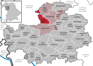
| Location of the Markt Bibart market in the Neustadt an der Aisch-Bad Windsheim district | ||
Markt Bibart is a market in the district of Neustadt an der Aisch-Bad Windsheim in Middle Franconia . Markt Bibart is a member of the Scheinfeld administrative association .
geography
Geographical location
Markt Bibart is located in the Steigerwald exactly between Nuremberg and Würzburg an der Bibart .
Neighboring communities
Neighboring communities are (clockwise from the north): Oberscheinfeld , Scheinfeld , Sugenheim , Iphofen and Markt Einersheim .
Community structure
The municipality has six officially named municipality parts (the type of settlement is given in brackets ):
- Altenspeckfeld ( hamlet )
- Altmannshausen ( parish village )
- Enzlar (hamlet)
- Fuchsau (settlement)
- Bibart market (main town)
- Ziegenbach ( Kirchdorf )
history
Place name
The place was first mentioned in 816 as "Bibaroth". The place name is derived from an identical field name, the basic word of which is ōdi ( ahd. For wasteland, desert) and defining word bibar (ahd. For beaver ). The field name describes a barren area in which a noticeable number of beavers were to be found. This first mention can be found in the founding document of the Benedictine monastery Megingaudshausen . The derivation of the place name from ach ( Ache ) based on the second syllable of the personal name component -bert was also considered (due to the spellings allegedly documented since the Middle Ages as “Biberah” and “Byberach” as well as “Biberach”) . In 1457 the term market is encountered , which is not taken into account in the dialect pronunciation ( bīwətʰ ).
Until the 19th century
Bibart belonged to the prince-bishopric of Würzburg for centuries and was the seat of an office. Bibart was in the Franconian Empire and belonged to the county of Limburg-Speckfeld . During the Thirty Years' War , the Bibart market was looted by small Swedish associations from autumn 1631. In 1803, with the secularization of the Würzburg monastery , the place fell to the Kingdom of Bavaria .
Name change
On February 2, 1963, the community name Bibart was officially changed to Markt Bibart .
Religions
The population of Markt Bibart is predominantly Roman Catholic. There is also an Evangelical Lutheran parish.
Incorporations
On January 1, 1972, the previously independent municipality of Ziegenbach was incorporated. Altmannshausen was added on January 1, 1976.
Population development
In the period from 1988 to 2018, the population rose from 1850 to 1880 by 30 inhabitants or 1.6%.
politics
Market council
The municipal council has twelve members.
(Status: local election on March 15, 2020 )
badges and flags
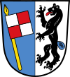
Markt Bibart has had a coat of arms since the 15th century.
|
Blazon : “ Split by blue and silver; forward an inclined, square, silver and red quartered flag on golden lance rod, rear one-set, red gezungter black beaver with blue tail. "
no municipal flag |
|
| Foundation of the coat of arms: Since 1390 the place belonged to the Hochstift Würzburg , where it remained until 1802. The little Würzburg racing flag in the front half of the shield reminds of this. In three seals from the 15th century to the beginning of the 18th century there is a small beaver head at the bottom of the lance shaft. In a council seal from the 18th century, the beaver, speaking for the place name, appears for the first time in its entirety, climbing up the rift line. In the literature it has appeared erect since 1856. From 1816 to 1835 the front half of the shield was red. |
Culture and sights
Buildings
The old Catholic parish church of St. Mary is a prime example of the post-Gothic real style .
The fortification of the place from the Middle Ages has hardly survived.
König-Ludwig-Turm , an approx. 21 m high wooden observation tower on the Hüßbachleite ( 388.9 m ), located south of Markt Bibart on the municipality border with Neundorf (Sugenheim ), an eastern branch of the 410.9 m high Hüßberg.
Architectural monuments
Economy and Infrastructure
traffic
Markt Bibart has a train station on the Nuremberg – Würzburg line . It is the stop of the VGN line R1 Nuremberg - Kitzingen. There is also a substation in its vicinity .
The surrounding area is served by several bus routes that also belong to the VGN network. However, they do not operate during off-peak hours and on weekends.
The federal road 8 runs through Markt Bibart . The B 286 joins the B 8 at the Enzlar district.
The Franconian Marienweg leads through the village.
Established businesses
The Rauch chipboard plant in Fuchsau produces over 500,000 m³ of chipboard annually with around 170 employees .
education
The primary and secondary secondary school I in Markt Bibart was closed in the 2004/2005 school year. Since then, Markt Bibart has only had one single primary school (Markt Bibart primary school).
Sons and daughters of the church
- Franziska von Fritsch (1828–1904), writer
- Herman Haupt (1854–1935), regional and church historian, librarian
- Ludwig Leuchsner (born February 24, 1578), lawyer, attorney in Nuremberg, Privy Councilor in Neustadt an der Aisch
literature
- Johann Kaspar Bundschuh : Biebert . In: Geographical Statistical-Topographical Lexicon of Franconia . tape 1 : A-egg . Verlag der Stettinische Buchhandlung, Ulm 1799, DNB 790364298 , OCLC 833753073 , Sp. 381-382 ( digitized version ).
- Johann Kaspar Bundschuh : Marktbibert . In: Geographical Statistical-Topographical Lexicon of Franconia . tape 3 : I-Ne . Verlag der Stettinische Buchhandlung, Ulm 1801, DNB 790364301 , OCLC 833753092 , Sp. 444 ( digitized version ).
- Gerhard Hojer: District of Scheinfeld (= Bavarian art monuments . Volume 35 ). Deutscher Kunstverlag, Munich 1976, DNB 760102457 , p. 179-189 .
- Wolf Dieter Ortmann: District of Scheinfeld (= Historical Place Name Book of Bavaria, Middle Franconia . Volume 3 ). Commission for Bavarian State History, Munich 1967, DNB 457000929 , p. 12-14 .
- Wolf-Armin von Reitzenstein : Lexicon of Franconian place names. Origin and meaning . Upper Franconia, Middle Franconia, Lower Franconia. CH Beck, Munich 2009, ISBN 978-3-406-59131-0 , p. 139 .
- Pleikard Joseph Stumpf : Market Bibart . In: Bavaria: a geographical-statistical-historical handbook of the kingdom; for the Bavarian people . Second part. Munich 1853, p. 695 ( digitized version ).
Web links
- Markt Bibart in the Topographia Franconiae of the University of Würzburg , accessed on September 25, 2019.
- Markt Bibart: Official statistics of the LfStat
Individual evidence
- ↑ "Data 2" sheet, Statistical Report A1200C 202041 Population of the municipalities, districts and administrative districts 1st quarter 2020 (population based on the 2011 census) ( help ).
- ^ Community Markt Bibart in the local database of the Bavarian State Library Online . Bayerische Staatsbibliothek, accessed on September 25, 2019.
- ↑ W.-A. v. Reitzenstein, p. 139.
- ^ Max Döllner : History of the development of the city of Neustadt an der Aisch until 1933. Ph. CW Schmidt, Neustadt ad Aisch 1950, p. 71.
- ↑ Christoph Beck: The place names of the Aisch valley and the neighboring valleys. Ph. CW Schmidt, Neustadt ad Aisch 1926, p. 44.
- ↑ WD Ortmann, p. 12 ff.
- ↑ Max Döller (1950), p. 234 f.
- ↑ a b Wilhelm Volkert (Ed.): Handbook of the Bavarian offices, communities and courts 1799–1980 . CH Beck, Munich 1983, ISBN 3-406-09669-7 , p. 565 .
- ^ Federal Statistical Office (ed.): Historical municipality directory for the Federal Republic of Germany. Name, border and key number changes in municipalities, counties and administrative districts from May 27, 1970 to December 31, 1982 . W. Kohlhammer, Stuttgart / Mainz 1983, ISBN 3-17-003263-1 , p. 723 .
- ^ Website of the UWG .
- ↑ Entry on the coat of arms of Markt Bibart in the database of the House of Bavarian History
- ↑ Bibart Market. In: Kommunalflaggen.eu. Retrieved May 11, 2020 .
- ↑ Markt Bibart observation tower ( Memento of the original from January 30, 2016 in the Internet Archive ) Info: The archive link was automatically inserted and not yet checked. Please check the original and archive link according to the instructions and then remove this notice. on steigerwald-info.de
- ↑ Markt Bibart observation tower on weinwanderwelt.de
- ↑ a b Map services of the Federal Agency for Nature Conservation ( information )
- ↑ http://www.rauchspan.de/unternehmen/daten-akte.html


