
Michelfeld (Marktsteft)
|
Michelfeld
City of Marktsteft
|
|
|---|---|
 |
|
| Height : | 214 m |
| Incorporation : | May 1, 1978 |
| Postal code : | 97342 |
| Area code : | 09332 |
 Location of Michelfeld (bold) in the municipality of Marktstefter
|
|
 Michelfeld with the village pond and St. Michael Church in the background
|
|
Michelfeld is a district of the town of Marktsteft in the Lower Franconian district of Kitzingen .
Geographical location
Michelfeld lies in the east of the Marktstefter municipality. Further to the north is the Hegholz as a forest area, further north with the district of Sickershausen begins the urban area of Kitzingen . In the east, the district of Mainbernheim with the abandoned settlement Rügerrieth and the forest department of the same name borders on Michelfeld. In the southeast there is a Willanzheim exclave. To the south is the Wasenmeisterei, which also belongs to Marktsteft . To the west is Marktsteft, which is connected to the district via state road 2420. The district town begins again to the northwest with Hohenfeld .
In terms of natural space, Michelfeld has shares in the Mainbernheim Plain , a sub-unit of the Steigerwald foothills with flat, undulating stream valleys and sanded Lettenkeuperböden .
history
Place name
The determiner Michael is a reference to an old place. Archangel Michael , popular since the 5th century , was especially venerated in mountain shrines. Michelfeld lies on the heights of the Main Valley.
Places with the ending -feld are an indication of controlled settlements from the time of the Franconian conquest . Between the Carolingian royal courts of Kitzingen and Riedfeld near Neustadt an der Aisch there was the "field chain" Hohenfeld, Michelfeld, Speckfeld, Frankenfeld and Langenfeld .
Local history
The Michelfeld area was populated at an early stage. In the hall there were finds from the urn field culture 1200–800 BC. Chr.
In 1153 the place was mentioned for the first time as "Michelveth" in a Würzburg bishopric. Documents from the year 1216 name "Conradus de Michelvelt".
No visible traces of the Michelfeld Monastery, founded in 1245, have been preserved. The women's convention received confirmation from the Pope in 1261. The monastery was subordinate to the abbot of the Oberzell monastery . The Bishop of Würzburg had the right to approve and object to the choice of the prioress. As early as 1305 the monastery for Premonstratensian women was closed and the nuns came to Tückelhausen.
On January 31, 1367, Charles IV acquired Michelfeld Castle from the brothers Heinrich and Hans von Meinberg. His son King Wenzel of Bohemia gave the village and castle Michelfeld together with Heidingsfeld , Mainbernheim and Prichsenstadt to the burgrave Johann von Nürnberg and the margrave of Ansbach-Brandenburg as pledge. Since Michelfeld was not released, the Brandenburg-Ansbach sovereign remained in the place. In 1501 it gave fiefs to Wilhelm von Bebenburg, from 1533 to 1611 to the von Hutten family and then to the Lords of Thüna. In 1663 the Margraves of Ansbach took over the property in the village and set up their own Vogtamt . This came to the Mainbernheim box office in 1689 . Unlike the neighboring Marktsteft, Michelfeld was never one of the six Ansbach “ Maindörfern ”. In the immediate vicinity of the village was the margravial Wasenmeisterei , which is still an independent district of Marktsteft today.
With Ansbach, Michelfeld fell to Prussia in 1791 and belonged to the Electorate of Bavaria from 1805. After belonging to the Grand Duchy of Würzburg from 1810, the place finally became part of the Kingdom of Bavaria in 1814. Michelfeld has been part of Marktsteft since the regional reform of 1978.
Population development
| year | 1834 | 1865 | 1868 | 1925 | 1939 | 1950 | 1970 |
|---|---|---|---|---|---|---|---|
| Residents | 351 | 365 | 351 | 302 | 293 | 415 | 333 |
coat of arms
|
|
Blazon : "In black, the standing Archangel Michael with a silver tunic and silver wings, who holds up the blue flaming sword with a golden handle in his right hand and a blue round shield on the left, which is covered with a golden and silver-rayed sun." |
| Foundation of the coat of arms: In 1967 the municipality of Michelfeld was awarded the coat of arms. The Archangel Michael refers to the place name Michelfeld. The tinging is an indication of the rule of the Margraves of Brandenburg-Ansbach, whose coat of arms also has the colors silver and black. |
Attractions

St Michael's Church with church square and war memorial
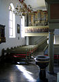
St. Michael interior

Gravestone of Andreas von Mooz

View to the altar
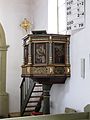
Pulpit of the parish church of St. Michael

Baptismal font


St. Michael
The tower of the parish church of St. Michael dates from the beginning of the 14th century. A new nave was built in 1603 under the village master, Anselm von Thüna . Despite an enlargement of the nave in 1715 and several renovations, the interior design from that time was retained. The pictorial representations and biblical quotations reveal the central beliefs of the builders to the visitor.
Before 1964 the altar had a neo-Gothic burst. It could not be preserved during the renovation in the year mentioned. During the last renovation from 2001 to 2004, the altar, built in 1964, was demolished and rebuilt from sandstone. Today it is only decorated with a simple wooden cross.
Castle complex
In the 13th and 14th centuries the family of "Conradus de Michelvelt" owned a castle in the village.
It was expanded into a moated castle. The description from 1604 describes the complex as follows: “The aristocratic residence and castle ... a jumping pipe and a scoop well in the castle courtyard, all with a strange wall, also surrounded by a moat, then reinforced by a castle bridge and gate, then the beautiful large forecourt ... , then reinforced with a strange (= special) gate. ”From the information given above and what is left today, one can conclude that there is a rectangular structure around an inner courtyard.
In 1604 Bernhard von Hutten offered the margrave his property. The Thirty Years War left heavy damage. Julius Albrecht von Thüna rebuilt the castle and estate and went into debt for it. On January 4, 1663, he and his son had to sell their property to Margrave Albrecht von Brandenburg. In 1713 the castle estate was divided into three properties and resold with ten editions.
Natural monument

The village pond with its edge vegetation was placed under nature protection.
Economy and Infrastructure
The economy is determined by the nearby district town of Kitzingen and the middle center of Ochsenfurt . Nevertheless, Michelfeld is not a pure residential community. Some residents are employed in local craft businesses. The majority of Michelfelder earn their living outside. Agriculture has lost its importance. There are only a few full-time farms left.
Personalities
- Werner Brockmann (1908 – probably 1943), pastor and member of the Confessing Church, pastor in Michelfeld 1937–1942
literature
- Johann Kaspar Bundschuh : Michelfeld . In: Geographical Statistical-Topographical Lexicon of Franconia . tape 3 : I-Ne . Verlag der Stettinische Buchhandlung, Ulm 1801, DNB 790364301 , OCLC 833753092 , Sp. 597 ( digitized version ).
- Gottfried Stieber: Michelfeld . In: Historical and topographical news from the Principality of Brandenburg-Onolzbach . Johann Jacob Enderes, Schwabach 1761, p. 592-594 ( digitized version ).
- Hans Bauer: Old and new coats of arms in the Kitzingen district . In: Yearbook of the district of Kitzingen 1980. In the spell of the Schwanberg . Kitzingen 1980. pp. 53-70.
- Fritz Mägerlein: Michelfeld . In: In the spell of the Schwanberg 1971. Heimat-Jahrbuch for the district of Kitzingen . Kitzingen 1971. pp. 203-213.
Web links
Individual evidence
- ↑ a b c d Fritz Mägerlein: Marktsteft and the six Ansbach "Maindörfer" . Siegfried Greß, Marktbreit 1983, ISBN 3-920094-38-7 .
- ↑ "To the southern tip of the Main Triangle" - Tour 2 . 2. Michelfeld. In: Evang. – Luth. Deanery Kitzingen (ed.): Gesegnetes Land . Paths through the Evangelical Dean's Office Kitzingen am Main. Kitzingen 2012.
- ↑ Erich Schneider: Monasteries in Bavaria. Michelfeld (Lower Franconia). House of Bavarian History, accessed April 2, 2013 .
- ↑ Susanna Berger: The Marktstefter district . In: District Kitzingen (ed.): Art and culture guide through the district Kitzingen . 2nd Edition. Farbdruck Brühl, Marktbreit 1993, p. 95 .
- ↑ W. Haberstumpf: The new church administrations according to the law of July 1, 1834 or instructions for the election, property briefing, the sphere of activity and course of business of the church administrations on the basis of the existing laws, ordinances and instructions: according to official Edit sources Ed .: W. Haberstumpf. Pössenbacher, Munich 1834, p. 24 ( online [accessed July 28, 2013]).
- ↑ Valentin Grübel: Official and address manual for the k. bayer. Administrative district of Lower Franconia and Aschaffenburg: edited from official sources . Ed .: Valentin Grübel. Self-published d. Author, Würzburg 1865, p. 36 ( online [accessed October 9, 2013]).
- ↑ Joseph Heyberger, Arthur von Ramberg, Michael Friedrich Heil (eds.): Topographical-statistical manual of the Kingdom of Bavaria . Cotta, Munich 1868, p. 1175–1176 ( online [accessed October 8, 2013]).
- ↑ Mägerlein, Fritz: Michel field . P. 206.
- ^ Bauer, Hans: Old and new coats of arms in the district of Kitzingen . P. 63.
