
Schulerloch nature reserve
|
NSG Schulerloch
|
||
 Schulerloch nature reserve |
||
| location | Essing , Kelheim District , Bavaria | |
| surface | 12.67 hectares | |
| Identifier | NSG-00087.01 | |
| WDPA ID | 82557 | |
| Geographical location | 48 ° 56 ' N , 11 ° 49' E | |
|
||
| Setup date | 1968 | |

The Schulerloch is a nature reserve in Essing in the Lower Bavarian district of Kelheim in Bavaria .
location
The nature reserve (NSG) is located about 2.4 kilometers east of Essing. It is part of the nature park Altmühltal , the landscape conservation area protection zone in the nature park Altmühltal the Fauna-Flora-Habitat -region dry slopes in the lower Altmühltal with Laaberleiten and Galgental and the EU bird sanctuary -region rocks and hillside forests in the Altmühl, Naab-, Laber- and Danube Valley .
description
The approximately 13 hectare area is a steppe heather forest with a lime beech forest and some rocks with karst caves . The school cave Schulerloch is named after the NSG . The pinnacles along the Altmühl are reef formations of the warm Jura Sea , which spread here 150 million years ago. The rocks here are often interspersed with cavities. The caves were already used by humans in the Stone Age . The Schulerloch can be visited during the warm season. The cave is designated by the Bavarian State Office for the Environment as a valuable geotope stalactite cave Schulerloch (show cave) (273H001). In winter the cave is an important wintering place for endangered bat species and is closed for cave protection reasons . The inaccessible Kleiner Schulerloch is also located near the show cave .
A closed lime beech forest grows on the sunny Altmühl slope. In the rocky places there is the unique, sparse forest type steppe heather forest . You can find here u. a. the ash root .
The nature reserve was designated on February 1, 1968 for the first time and on November 24, 1976, June 9, 1988 July 22, 1992 with an amended ordinance.
See also
- List of nature reserves in the Kelheim district
- List of landscape protection areas in the Kelheim district
- List of FFH areas in the Kelheim district
- List of EU bird protection areas in Lower Bavaria
- List of geotopes in the Kelheim district
Picture gallery

Rock growth in the NSG

View in Altmühltal
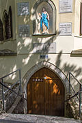
Entrance to the Schulerloch

Sinter basin in the Schulerloch


Web links
Individual evidence
- ↑ Location of the nature reserve in the Bavaria Atlas (accessed on March 18, 2017).
- ↑ World Database on Protected Areas - LSG protection zone in the Altmühltal Nature Park (English)
- ↑ 7036371 dry slopes in the lower Altmühltal with Laaberleiten and Galgental. (FFH area) Profiles of the Natura 2000 areas. Published by the Federal Agency for Nature Conservation . Retrieved March 18, 2017.
- ↑ World Database on Protected Areas - Dry slopes in the lower Altmühltal with Laaberleiten and Galgental (English)
- ↑ 7037471 Rocks and hillside forests in the Altmühl, Naab, Laber and Danube valleys. (EU bird sanctuary) Profiles of the Natura 2000 areas. Published by the Federal Agency for Nature Conservation . Retrieved March 18, 2017.
- ↑ World Database on Protected Areas - Rocks and hillside forests in the Altmühl, Naab, Laber and Danube valleys (English)
- ↑ www.lfu.bayern.de, profile of the geotope stalactite cave Schulerloch (show cave) (accessed on March 18, 2017).
- ↑ www.regierung.niederbayern.bayern.de, leaflet on the nature reserve
- ↑ www.regierung.oberpfalz.bayern.de, regulation of the nature reserve (accessed on March 18, 2017)


Inland dunes near Siegenburg and Offenstetten | Goldau | Hirschberg and Altmühlleiten | Klamm and Kastlhang | Ludwigshain | Mattinger slopes | Niedermoor south of Niederleierndorf | Sandharland Heath | Prunn Palace | Schulerloch | Sippenauer Moor | Former NATO training ground Siegenburg | Danube breakthrough near Weltenburg