
Danube breakthrough near Weltenburg
|
Weltenburger narrow
|
||
 Weltenburger Enge near Weltenburg Abbey |
||
| location | Kelheim , Lower Bavaria , Bavaria , Germany | |
| surface | 5.6 km² | |
| Identifier | NSG200.002 (NSG-00089.01) | |
| WDPA ID | 6977 | |
| Natura 2000 ID | DE7136301 | |
| Geographical location | 48 ° 54 ' N , 11 ° 50' E | |
|
||
| Setup date | May 11, 1970 | |

The Danube Gorge near Weltenburg is a bottleneck in the Danube Valley in the Lower Bavarian district of Kelheim , which is recognized as a nature reserve and geotope . The section of the valley in the southern Franconian Jura is officially called Weltenburger Enge . This section of the valley was designated as a national natural monument on February 13, 2020 .
location
Weltenburger Enge is located on the Lower Bavarian section of the Danube between Kelheim and Weltenburg Abbey . The extension of the nature reserve is about 560 hectares , is 5.5 kilometers long and about 400 meters wide.
description
The area is a designated nature reserve and has the cadastral number NSG200.002. The area was already designated as a natural monument under Ludwig I in 1840 . The nature reserve , which has existed since 1938, was awarded the European diploma on March 5, 1978 . It is also part of the Natura 2000 network and part of the protected area DE7136301, Weltenburger Enge and Hirschberg and Altmühlleiten . The Weltenburger Enge valley section was designated as a national natural monument on February 13, 2020 .
In addition, the area is also listed as geotope 273R005. In 2002 the Weltenburger Enge was awarded the official seal of approval “ Bavaria's most beautiful geotopes ” by the Bavarian Ministry of the Environment . In 2006 the Danube breakthrough valley was added to the list of 77 awarded national geotopes in Germany.

Geologically, the Weltenburger Enge belongs to the Upper Jura ( limestone ), the formation with the highest fossil fuel content in Germany, which was deposited around 150 million years ago when the area was still a shallow sea.
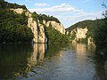
The breakthrough valley is bordered by up to 80 m high rock walls in which there are numerous smaller caves. Between the so-called Stillen and the Long Wall , the current narrows to 110 meters and reaches a water depth of 20 m. The limestone formations bear imaginative names like The Three hostile brothers , predators rocks , Kuchelfelsen , Petrified Virgin , Bavarian Lion , bishop's cap , two self-kissing , Romans rock , Peter and Paul , apiary (a stone with hollows as honeycomb), Napoleon suitcases (the according to a legend he should have forgotten when retreating).
In contrast to the enormous water depth at the point of the actual breakthrough, there is a less noticeable area about halfway between Kelheim and Weltenburg, the so-called Wipfelsfurt . Here is the shallowest part of the Danube between Ingolstadt and Regensburg. The area was possibly formed as a result of a meteorite impact during the Ries event 15 million years ago.
Emergence
The term “Danube Gorge” for the Weltenburger Enge does not apply geologically, as the valley was largely cleared by several Danube tributaries during the Ice Age . These had worked their way up the mountain by means of retrograde erosion and created the current bed of the Danube around 80,000 years ago.
The original valley of the Danube was the lower Altmühltal . Only since the penultimate glacial period , the Riss glacial period , did the original Danube ("Altmühldonau") , which originally flowed further north along the line Wellheim - Dollnstein - Eichstätt - Beilngries - Riedenburg , change its course and now use the channel of the already existing Weltenburger Narrows; the Danube itself did not break through here, in contrast to the Danube breakthrough near Beuron near Sigmaringen in Baden-Württemberg.
When examining the gravel terraces, it was found that the Danube was only digging the lowest 10–15 m here, while the smaller tributaries had previously dug a valley 180 m deep.
Sights in the area
In addition to well-known long-distance hiking trails such as the Jakobsweg , Jurasteig and Altmühltal-Panoramaweg, there are also numerous local hiking trails from Kelheim to Weltenburg Abbey. Downstream before Kelheim is the Klösterl , a former monastery dating back to a hermitage from 1450, whose cave church, newly built in 1603 with a natural rock roof inside, is a specialty among European rock churches . Its frescoes are badly damaged. To the south of Weltenburg Abbey are the remains of the Abusina Roman fort in Eining , which secured the Upper Germanic-Raetian Limes that ended on the opposite bank .
To the northeast of the breakthrough rises the Liberation Hall on the Michelsberg .
Picture gallery
View of the Danube Gorge from Weltenburg Abbey

Striking rock section (Bavarian lion) at the actual Danube breakthrough

Overview from Michelsberg over the breakthrough area

View through the Danube breakthrough to the Liberation Hall

Rings embedded in the "Long Wall", the most dangerous breakthrough rock

Patron saint St. Nepomuk in the "Long Wall"


See also
Web links
- Landschaftspflegeverband Kelheim VöF: Area management nature reserve "Weltenburger Enge"
- Location and extent of the nature reserve (OpenStreetMap) (accessed on July 9, 2013)
- Nature reserves (NSG) in the Niederbayern administrative region (accessed on July 9, 2013)
- Information page about the Danube breakthrough
- Danube breakthrough in Weltenburg
- Ordinance on the National Natural Monument Weltenburger Enge of February 11, 2020
Individual evidence
- ↑ Bavarian State Ministry of Environment and Health, NSG200.002 nature reserve Weltenburger Enge ( Memento of the original from August 7, 2013 in the Internet Archive ) Info: The archive link has been inserted automatically and has not yet been checked. Please check the original and archive link according to the instructions and then remove this notice. (Accessed July 9, 2013)
- ↑ Natura 2000: DE6534371, Weltenburger Enge and Hirschberg and Altmühlleiten (accessed on July 9, 2013)
- ↑ Weltenburger Enge becomes the first national natural monument in Bavaria. In: idowa.de. February 12, 2020, accessed February 13, 2020 .
- ↑ Bavarian State Office for the Environment, Geotop Weltenburger Enge (accessed on July 9, 2013; PDF; 188 kB)
- ^ Bavarian State Office for the Environment: Bettg'schichten - Weltenburger Enge. In: Hundred Masterpieces - The Most Beautiful Geotopes of Bavaria , Augsburg 2012, ISBN 978-3-936385-89-2 , p. 230f.
- ↑ Ulrich Lagally: Pirate Piece of a River - The Weltenburger Enge near Kelheim in the Danube Valley. In: Ernst-Rüdiger Look, Ludger Feldmann (Ed.): Fascination Geology. The important geotopes of Germany , E. Schweizerbart'sche Verlagsbuchhandlung, Stuttgart 2006, ISBN 3-510-65219-3 , pp. 159f.