Michelsberg (Kelheim)
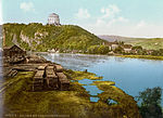
The Michelsberg is a mountain near Kelheim in Lower Bavaria in the confluence of the Danube and Altmühl rivers , which rises 126 meters above the Danube. The Liberation Hall, built in the 19th century, stands on it .
Oppidum
An Iron Age oppidum called Alcimoennis was located there between the third and first centuries BC . The oppidum was mentioned under this name by the geographer Claudius Ptolemy in his Geographike Hyphegesis around 100 AD and described as being at the confluence of "Alcomona" (Altmühl) and "Danubius" (Danube).
With an area of 600 hectares, it was probably one of the largest of its kind in all of Europe. The settlement was protected by staggered walls across the Michelsberg, while the steep slopes to the Danube and Altmühl formed a natural barrier. Three earth walls still exist today. The outer, western wall is 3.28 km long and extends from the edge of the Danube to the southern bank of the Altmühl. The Altmühlwall on the southern bank of the Altmühl along the river is at least 3.3 kilometers long. The inner wall is 930 meters long.
The fortifications consisted of an eleven meter wide and six meter high earth wall and a wall in front of it, against which earth was piled up. The wall consisted of wooden posts between which limestone slabs were piled up without mortar. The posts were anchored about a meter deep in the ground and towered over the dam by up to two meters. In order to withstand the pressure of the earth wall, the wall was connected by tension with earth anchors in the dam. In the event of an attack, the townspeople were able to fight the attackers from the wooden earth walls. The remains of four pincer gates can still be seen in the area.
Mining
The area is covered by extensive Iron Age and medieval ore mining sites . In the bottom of the Michelsberg you can find layers of coal and slag up to three meters thick. Because of this, it can be assumed that Alkimoennis was an Iron Age "industrial complex" on which iron ore was mined and smelted on a large scale.
reconstruction
In the inner courtyard of the Archaeological Museum in the Kelheimer Herzogskasten , an original section and the reconstruction of the original height of the fortification wall can be viewed.
Surroundings
The Weltenburger Enge nature reserve begins in a south-westerly direction up the Danube , followed by the Danube Gorge and Weltenburg Monastery after a few kilometers .
literature
- Michael M. Rind : Oppidum Alkimoennis and surroundings . In: Sabine Rieckhoff / Jörg Biel : Die Kelten in Deutschland , Stuttgart, Theiss 2001, p. 390.
- Hilde Krause, Hanns Haller (Ed.): Where the Liberation Hall is . Niederbayerische Hefte 10, 1963 (Leonhard Wolf Publishing House, Regensburg).
Web links
Coordinates: 48 ° 55 ' N , 11 ° 52' E


