
Käsrinne near Heidenheim
Coordinates: 49 ° 2 ′ 1 ″ N , 10 ° 43 ′ 53 ″ E

The Käsrinne near Heidenheim is a limestone tufa near Heidenheim in the central Franconian district of Weißenburg-Gunzenhausen in Bavaria .
location
The Käsrinne is located about 2.2 km northwest of Heidenheim on the western slope of the Yellow Mountain .
description
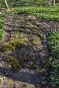
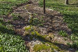
This stone channel is an approximately 150 meter long and up to 40 centimeter high moss-covered calcareous channel , the width of which is up to 30 centimeters at the top. This makes it the longest stone channel in the Franconian Alb . As the lower slope becomes flatter, it becomes lower and narrower. The water rises from two smaller flow sources , which soon unite to form a common stream. The shallow stream meanders and only reaches the actual stone channel after about 50 meters. On his way there he formed some smaller sinter basins .
The cheesy water made cheesy by the lime gave it the name Käsrinne and it was first mentioned in writing in the 15th century. The natural development of the channel was partially disturbed by attempts to accelerate growth.
The area is designated as Geotope 577R018 by the Bavarian State Office for the Environment .
See also the list of stone gutters in Bavaria .
Emergence
Lime tuffs come in various morphological forms as large tufa beds, sintered terraces, tuff cascades or, as here, as limestone turf channels. Such channels are always tied to springs whose water has a particularly high lime content. Small, but constantly flowing springs, under favorable circumstances, create such stone gullies.
The groundwater cannot seep deeper here due to the underlying water-retaining layer of the regal clay and is directed to the side of the spring outlet.
The water temperature at the source fluctuates around 8 degrees. At the source outlet the water experiences a pressure relief, a mixing with the air and at the same time a change in the ambient temperature. Some of the carbon dioxide dissolved in the water escapes, causing lime to precipitate out of the water, which, favored by mosses and other plant parts, settles on the bottom of the channel. Certain algae are able to precipitate the lime dissolved in the water. The branched mosses then catch the precipitated lime. Algae and moss cause the upward growth of the stone channel on the initially flat sintered surface. The mosses find their best habitat on the edge of the stream bed in a damp and calcareous environment. In order to always get enough sunlight for their growth, they must always grow upwards or to the side out of the encrustation caused by the lime precipitation. The algae, on the other hand, prefer to live on the bottom of the flow channel; the solid lime deposited by them seals the channel downwards and to the side. In this way they ensure that the watercourse is channeled. As long as the water supply between the spring and the stone channel is not interrupted, it grows higher and higher, by a few millimeters every year.

Access
The Käsrinne is freely accessible all year round. Following the Quellenwanderweg, the source is easily accessible on foot or by bike via forest roads and forest paths. The channel itself is in the forest and there is no path along it.
The sensitive, porous tuff limestone must not be stepped on or destroyed. Above all, the channel must not be dammed up and the edges must not be broken. The growth of the porous limestone tuff would be permanently changed, the running of the fine channel would be impaired and further natural growth would be severely disturbed. If the water leaves the channel at any point, it will fall dry as it continues, and it will take a very long time until a new one is created on the new path of the water.
photos

Southern source

Northern source
Sinter terrace in the upper stream

A "cheesy" spot
Outlet of the gutter


Web links
Individual evidence
- ↑ Location of the Steinerne Rinne in the Bavaria Atlas (accessed April 3, 2014).
- ↑ Geotope: Steinerne Rinne northwest of Heidenheim (accessed on April 3).
- ↑ OpenStreetMap: Quellenwanderweg ( Memento of the original from April 7, 2014 in the Internet Archive ) Info: The archive link has been inserted automatically and has not yet been checked. Please check the original and archive link according to the instructions and then remove this notice. (Retrieved April 3, 2014)