
Hesselberg
| Hesselberg | ||
|---|---|---|
 The Hesselberg from the southwest |
||
| height | 689.4 m | |
| location | between Dinkelsbühl and Wassertrüdingen | |
| Mountains | Singularity in the foreland of the southern Franconian Alb , Franconian Keuper-Lias-Land | |
| Dominance | 34 km → Wöllerstein ( Swabian Alb ) | |
| Notch height | 233 m ↓ St 2220 between the Langfurth districts of Oberkemmathen and Matzmannsdorf | |
| Coordinates | 49 ° 4 '12 " N , 10 ° 31' 37" E | |
|
||
| Age of the rock | law | |
| particularities | highest mountain in the Franconian Keuper-Lias-Land and Middle Franconia , transmitter Hesselberg | |
 Morning mood with a view of the Hesselberg (from the west) |
||
 View from the Hahnenkamm over Ostheim to the Hesselberg (from the east) |
||

The Hesselberg ( ) is the highest elevation in Middle Franconia at 689.4 m . It is located 4 km northwest of Wassertrüdingen and 60 km southwest of Nuremberg .
The mountain, which is occasionally (incorrectly) referred to as the “highest mountain of the Franconian Alb ”, is located north of the Nördlinger Ries crater, which separates the Franconian and Swabian Alb, in the foothills of the Southern Franconian Alb , Franconian Keuper-Lias-Land , within which it represents an island-like singularity .
The first known name was Öselberg ; its meaning was probably desolate mountain . From this name later Eselberg and finally the current name Hesselberg developed . As an old witness mountain, the mountain gives a revealing insight into the geological history of the Jurassic period . He is also witness to an eventful history. Many events have been handed down from generation to generation and have mixed with the facts in fabulous legends. Today, the Hesselberg is primarily a destination that offers a view of the Alps 150 km away when the weather is very clear .
Position, shape and extent
The Hesselberg lies between the villages of Röckingen (south-east), Gerolfingen (south), Wittelshofen (south-west), Ehingen (north) and the district of Lentersheim (north-east), all of which belong to the administrative community of Hesselberg in the district of Ansbach , which are just over 1 km away . The municipal boundary between Ehingen and Gerolfingen runs over the western part of the ridge with its highest peaks, and that between Ehingen and Röckingen runs over the eastern ridge.
The mountain has a length of about 6 km in an approximate west-east orientation and is on average 1–2 km wide. With the exception of the south side, most of the slopes are covered with coniferous or mixed forest. In the upper area and especially on the eastern slope of the Röckinger Berg there are also larger areas with deciduous forest . The striking south side is largely free of forests in the upper part. In the south and north-east slopes there are large-scale grasslands with their typical juniper bushes . In its longitudinal axis, the Hesselberg can be divided into five zones (see panorama picture):


- Coniferous forest predominates in the western ascent area . The geological educational and hiking trail begins here.
- The western plateau, also called Gerolfinger Berg, with its doline-like depressions, its many hedges and bushes and some viewpoints has a particularly original appearance. The depressions did not arise naturally, but rather the result of former excavations. The material obtained here was used to build roads and to burn lime .
- The central part, also called Ehinger Berg, with the main summit and the television tower has been largely accessible again since 1994; previously this was a militarily cordoned off area of the US armed forces.
- Most important for tourism is the forest-free, eastern plateau known as Osterwiese or Röckinger Berg. This section serves as a take-off point for model airplanes and hang-gliders and as a viewing platform for hiking and strolling. On particularly clear days, even the Alps with the Zugspitze can be seen.
- The legendary, easternmost foothills of the Hesselberg are heavily forested and are called Schlössleinsbuck. This small hilltop is also known as the "Kleine Hesselberg". The Röckinger Berg and the Schlössleinsbuck are separated by the Druidental .
Geotopes
During a ceremony on September 24, 2005, Government Director Georg Schlapp honored the Hesselberg as one of Bavaria's most beautiful geotopes by the Bavarian State Office for the Environment (LfU) . There are also two individual geotopes on the Hesselberg. The former quarry on the Hesselberg (geotope number: 571A001) and the Dogger outcrop on the Hesselberg (geotope number: 571A018) are designated as geoscientifically valuable geotopes .
History and geological structure
The origin in the Jurassic period

200 million years ago, the Jurassic Sea stretched from the North Sea basin far to the south and covered the old Keuperland . At that time, the Hesselberg region was on the edge of this sea. Numerous tributaries brought huge masses of debris from the eastern mainland and formed a multi-layered landscape rich in animals and plants on the sea floor. Over the course of more than 40 million years, the different layers of the Jura rock were deposited one after the other: at the bottom those of the Black Jura (Lias), above that of the Brown Jura ( Dogger ) and, at the top, those of the White Jura (Upper Jura or Malm ). Each of these layers marks its own epoch through the typical rock and the species-specific fossils contained therein . Since some fossils only occur in certain rock layers, they are referred to as index fossils . In the Jurassic rocks, the key fossils are almost exclusively ammonites . In the course of the earth's history, the Jurassic Sea silted up completely. In further millions were erosion whole layers of rock removed. The protective hollow of the Schwarzjura, in which the Hesselberg is located, is the reason why the Hesselberg could not be attacked as strongly by wind and water as the plain between the mountain and the Hahnenkamm . The hard rock was able to withstand and left the Hesselberg as a striking witness mountain , which today juts out of the landscape like an island. This type of formation of a mountain is called relief reversal in geology .
The rock layers of the mountain
The information boards on the geological educational trail explain the history of its origins to the hiker in a very clear way. The three main levels of the Jura (Lias, Dogger, Malm) are each divided into six sub-levels in geology and denoted by the Greek letters alpha to zeta ( Quenstedt structure ) . The rocks present in the layers are assigned to these names.
The layers of the Black Jurassic (Lias)

The dark colors of clays and marls give the Black Jura its name. This approximately 50 m thick layer forms the fertile hilly surroundings of the mountain. Its lowest layers (Lias alpha to gamma) are located below the earth's surface. The "Amaltheenton" (today Amaltheenton Formation , Lias delta) forms the highest lower level of the Lias with a thickness of 35 m. A special feature is the 10 m thick Posidonia schist formation (Lias epsilon). It also contains fossils of larger animals, for example ichthyosaurs have been found in this layer. The Posidonia slate quarry at the beginning of the nature trail is unique in a wide area and has been designated as a geological natural monument. Searching for and collecting fossils is therefore prohibited. The approximately 2.7 m thick Jurensis marl formation (Lias zeta) joins these easily recognizable layers of slate .
The layers of the Brown Jurassic (Dogger)
The deep brown weathering colors of the higher layers give the brown Jura its name. The cause is the higher iron content . Overall, the 135 m thick layer of the Dogger forms the main ascent of the Hesselberg slopes. The lowest layer is the 75 m thick "Opalinus Clay" (today the Opalinus Clay Formation ) (Dogger alpha). The unevenness of the meadows is the result of slope slides; the floors in this area are very prone to slipping. Above the Opalinus Clay is the 40 m thick layer of "iron sandstone" or the iron sandstone formation (Dogger beta). This layer is particularly striking because of its steep ascent. Since the Opalinus Clay is impermeable to water, a spring horizon has formed at the transition to the iron sandstone . The layers of the Dogger gamma ( Wedelsandstone formation with Sowerbyi bank at the base), the Dogger delta ("Ostreenkalk" or Ostreenkalk formation ) (4 m) and the Dogger epsilon ( Sengenthal formation ) (2 m) are rich in Fossils. The "Ornatenton" (now Ornatenton formation ) (Dogger zeta) , which is only 2 m thick, forms the end of the Dogger . This thin layer forms a terrace around the Hesselberg. The houses of the adult education center were built on its south side .
The layers of the White Jura (Malm)

This uppermost Jura layer is named for its light color. In the Franconian Alb, these layers can reach heights of up to 400 m. On the Hesselberg, however, most of them have already been removed, so that only 85 m remain. The Malm rocks are partly marine sediments and partly reefs from former sea sponges . At the main summit, the rock formed from the sponge reefs is widespread. The light limestone of the White Jura has always been a popular building material for house building ( quicklime ) and road construction ( gravel ). The depressions created in the area of the western plateau are the result of material excavations. The lowermost layers form the summarized as Malm alpha, about 25 m high Impressaschichten (deep Malm alpha) and the Bimammatumkalke (Malm high alpha). The old name of the planula limestone (Malm beta) is factory limestone, which in turn indicates its use as a building material. This approximately 15 m high layer, heavily interspersed with sponge reefs, builds up the plateau of the Osterwiese. The small quarry below the main peak is in its lower region of Planulakalken and in its upper part it shows the Ataxioceratenschicht (Malm gamma). The main summit is built up by this layer, which is up to 20 m thick. The upper layer of the Malm gamma and the layers of the Malm delta to Malm zeta have already been eroded on the Hesselberg.
Settlement history and important events in the Hesselberg area
In some parking lots in the area of the tourist region Hesselberg, the responsible municipalities put up display boards which give a good insight into the settlement history of this region.
Prehistory and early history
Already in prehistoric times, the first settlers sought the Hesselberg as a place of refuge and residence. Archaeological finds from the Stone Age (around 10,000 to 2000 BC) were mainly made in the area of the Osterwiese. During the Bronze Age (approx. 2000 to 1300 BC) the mountain was continuously settled. In the Urnfield Period (around 1200 to 750 BC), the settlement was surrounded on the plateaus with circular walls , ditches and ramparts . The remnants of the 5 km long ramparts around the Osterwiese, the Ehinger and the Gerolfinger Berg still give an idea of the former importance of this fortification. An important political, economic, and religious tribal center developed behind the protective masonry. For a long time these systems were assigned to the Celts . But only a single find (weapons equipment of a warrior) from the Latène period (500 to 15 BC) indicates a brief visit by the Celts. In the troubled times of the Great Migration and until the Middle Ages, people used the old ramparts of the Hesselberg as a place of refuge and for defense. In the city museum in Oettingen and in the museum for prehistory and early history in Gunzenhausen numerous exhibits in the form of tools and weapons can be viewed.
The Romans

Under the emperors Domitian (81–96 AD) and Hadrian (117–138), the Romans moved the border of their province of Raetia further north. They expanded the Limes border wall to protect it from the Teutons and equipped it with numerous defense and watchtowers. Large forts were built in the immediate vicinity of the Hesselberg . The last and strongest expansion of the Rhaetian Limes took place under Emperor Caracalla (around 213 AD). The border wall crossed the rivers Wörnitz and Sulzach in a north-south direction in the west of the mountain . A few kilometers north of Wittelshofen it made a bend to the east. Through this kink, the strategically important Hesselberg was included in the Roman Empire . There were castles at Aufkirchen , Ruffenhofen , Dambach and Unterschwaningen ( see also castell Unterschwaningen ). The Ruffenhofen fort was the largest in the Hesselberg area. The archaeologists could not prove any Roman buildings on the mountain itself . Remnants of the Limes can still be found as stone ridges hidden in forests. Most of the civil and military wall remains are now hidden in the soil of the meadows and fields. A Roman park is currently being laid out above the Ruffenhofen fort. Some Roman finds can be seen in the local history museum in Weiltingen .
The Alemanni and Franks
Around 260 AD, Alemannic - Elbe Germanic associations broke into the region and destroyed the fortifications of the Limes, forts and residential areas. The Romans had to move the border of their empire back to the Danube. The Alemanni founded the first farm groups and worked the land as farmers and ranchers. The pronounced long- striped corridor is next to the place names with the ending -ingen a sure reference to an Alemannic foundation. The villages of Röck ingen , Eh ingen , Gerolf ingen , Weilt ingen and Irs ingen have their origins in this time. Towards the end of the 5th century, the Franks came from the lower Main Valley and initiated the second settlement movement. Under the Merovingian king Clovis I , they defeated the Swabians / Alamanni in 496 to 506 , who lost their northern territories , which previously reached into the Neuwied basin , and were pushed back behind the line Oos - Hornisgrinde - Asperg - Hesselberg; to this day this line corresponds almost exactly to the dialect border between East Franconian and Swabian / Alemannic . Although the Franks sometimes acted with great violence against the Alamanni, mixed settlements developed in the Hesselberg area (e.g. Ehingen and Röckingen), in which, however, a Franconian village chief was always the head. The Franks founded several towns Lenters home , Obermögers home , Geils home , Franconia hofen and King hofen . The Franconian farmers introduced the three-field economy with the Flurzwang , which was practiced until modern land consolidation . In the 7th century began under the Merovingian King Dagobert I of Augsburg from the Christianization one. Anglo-Saxon missionaries founded the Hahnenkamm Monastery in Heidenheim under the Frankish Carolingians in the 8th century .
The middle age

In the early Middle Ages , the Hesselberg area belonged to the forest areas of the kings. Sparse remains of medieval castle complexes can be found on the Ehinger Berg and the Schlössleinsbuck. The system on the Ehinger Berg dates back to the Carolingian- Ottonian period (8th – 9th centuries). Grave finds indicate a violent end in the 10th century by Hungarian soldiers. The Hungarians burned down the entire castle. The facility on Schlössleinsbuck was originally built as a refuge in the 9th century . The lords of Lentersheim built it into a fortified knight's castle in the 11th or 12th century. The following can be read about the fall of the castle in the family register of the Lords of Lentersheim: When Conrad von Lentersheim returned from northern Italy from the campaigns of Emperor Frederick II in 1246, his castle was completely destroyed. He then started building a completely new castle in Neuenmuhr. In fact, in 1239 soldiers from the Hesselberg area also marched alongside the Staufer Emperor Friedrich II mentioned here in the fight against Pope Gregory IX. to Italy. The lords of Lentersheim lived in their castles in Alten- and Neuenmuhr, today's Muhr am See , until they died out at the beginning of the 19th century .
After that, the direct settlement of the Hesselberg ended. The village of Aufkirchen, fortified in the Middle Ages, had a city wall and four city gates. At that time, Aufkirchen had town rights .
The burgrave and margrave period
The origins of the Burggrafenzeit in the Middle Franconian area go back to the High Middle Ages , when the Hohenstaufen Emperor Heinrich VI. the Zollern Friedrich III , who came from Swabia . enfeoffed in 1192 with the heritable imperial fief of the Nuremberg burgrave office. As burgrave Friedrich I of Nuremberg, he founded the Franconian line of the House of Hohenzollern . Due to the later marriage and exchange policy, the Franconian Zollern gained more and more possessions and influences in the Hesselberg area.
In 1331 the burgraves moved their seat to Ansbach. In 1363 they were raised to the rank of imperial prince and in 1417 enfeoffed with the margraviate of Brandenburg . On May 6, 1525, the Peasants' War also broke out in southern Franconia . As the leading head of the local uprising, the Schmalzmüller (the Schmalzmühle is between Röckingen and Reichenbach at the foot of the Hesselberg), Thomas Wiedemann, called on the local farmers to revolt against the authorities. The Schmalzmüller was a free farmer at that time, but lost all his rights after the defeat of the farmers. On this day the rebellious farmers met on the summit of the Hesselberg. From there they moved to Wassertrüdingen and captured the margravial Vogt of the city. Then they looted the Auhausen monastery . On the way to Heidenheim , they were captured or killed by margrave soldiers from Gunzenhausen .
In the Thirty Years War (1618–1648) large areas of what is now Central Franconia were largely devastated and depopulated. Only at the end of the 17th century did the margraves' economic and financial situation improve. They naturalized Austrian and French religious refugees and supported Jewish traders in setting up their own businesses, so that many Jews also settled in the villages around the Hesselberg . The lavish courtship of the margraviate of Brandenburg-Ansbach and constant quarrels with the imperial city of Nuremberg led to the principality's high level of debt (when the last margrave took office, the debt amounted to five million guilders; when he abdicated 30 years later, the debt level was only 1.5 Million guilders). In addition, the margraves pursued a mercantilist economic policy and expanded the agricultural education system. The last Margrave Alexander ceded his principality to the Kingdom of Prussia in 1791 in return for an annual annuity .
19th century


An important date in the history of the mountain was June 10, 1803, when the Prussian King Friedrich Wilhelm III. as part of a visit to his Franconian lands climbed the Hesselberg. The king donated the Hesselberg Mass as a souvenir . 1806 Hesselberg region came in the wake of a countries exchange between the kingdoms of Bavaria and Prussia to Bavaria: Bavaria acquired the Prussian principality of Ansbach with the Hesselberg - Prussia in return with the hitherto Wittelsbach Duchy of Berg (capital Dusseldorf ) compensated in the Lower Rhine (Bavarian-Prussian treaty of Paris, February 15, 1806). In 1808 the first municipal code established municipal self-government . The second Bavarian municipal edict of 1818 expanded municipal self-government. Many small villages got their own administration and the status of a municipality in the legal sense as legal persons.
Julius Streicher's franc days
Before the Second World War , Jewish life and culture also played an essential role in the entire Hesselberg area. Jewish residents were mentioned in documents as early as the 14th century. Many Jews were honored as businessmen and scholars. But supporters and followers of National Socialism also destroyed the synagogues in the towns and villages around the Hesselberg and drove them out or deported them to concentration camps . The Franconian Gauleiter Julius Streicher made the Hesselberg a political meeting place for the National Socialists. From party rallies, at which Adolf Hitler was also present in 1930, the franc days held annually until 1939 developed after the NSDAP came to power in 1933. These were in addition to the Nuremberg Reich party rallies , the largest Nazi rallies in Franconia. Hermann Göring attended the Frankentage twice as a speaker. Up to 100,000 visitors heard the anti-Semitic speeches of Julius Streicher on the Osterwiese , who had set himself the goal of exterminating the Jews. At that time, the Hesselberg was given the title “Holy Mountain of the Franks”. Evidence from this era can no longer be found on the Hesselberg today. The high-flying plans of the Nazi party leadership were never realized, the construction of the Adolf Hitler School and the construction of a Julius Streicher mausoleum. Before the outbreak of the Second World War, the National Socialists were only able to complete an administrative building with a garage. This garage was later used as a chapel by the refugees housed on the mountain.
After 1945
Hesselberg has been in church hands since 1951. It is the founding year of the Evangelische Landvolkshochschule and the year of the first event of the Bavarian Evangelical Church Congress . Between 1945 and 1992 the area around the main summit was used by the American armed forces as a radar station . In 1972, as part of the district reform, the Dinkelsbühl district , which also included the Hesselberg communities, was dissolved and integrated into the Ansbach district . In the later community reform , many formerly independent small communities became today's communities or administrative communities .
The Hesselberg region today
Facilities and events on the Hesselberg

The Evangelical Lutheran Adult Education Center in Hesselberg was founded as the first adult education center in Bavaria on May 14, 1951. Its central task is adult education for rural diakonia (family carer, village helper, work helper). On September 15, 2005, the name was changed to Evangelisches Bildungszentrum Hesselberg (EBZ Hesselberg) . The background is an expansion of the educational offer with a focus on "Faith, rural areas and personal development" , says Pastor Bernd Reuther, chairman of the new education center. Furthermore, guest groups should increasingly be addressed with their own educational programs.
The Evangelical Lutheran dean's office in Ansbach has expanded the old Hesselberghaus near the summit into a popular leisure home for young people.
The most important event is the Bavarian Evangelical Church Congress, which is known far beyond the regional borders. Every year on Whit Monday, thousands of Christians meet for this festival on the mountain. Since 1803, the Hesselberg Mass has traditionally been held on the Osterwiese every first Sunday in July; at that time the Prussian King Friedrich Wilhelm and his wife Luise visited the mountain.
Sending station on the Hesselberg
- → Main article Sender Hesselberg

The 119 m high television tower, visible from afar, is a basic network transmitter for the Bavarian DVB-T transmitter network. The transmission area includes the region of western Central Franconia and northern Swabia. The transmission tower, located at 49 ° 4 '6 ″ N , 10 ° 31 ′ 32 ″ E , is of an unusual design: It is designed as a hybrid tower and consists of a free-standing steel lattice tower as the substructure and a guyed transmission mast as the upper part. It also broadcasts the Radio 8 program on VHF .
The four communities around the mountain


The borders of four communities run across the Hesselberg. A special feature is that the main towns of these communities are located directly at the foot of the mountain, while the other parts of the community radiate almost star-shaped from these centers. In the north lies the municipality of Ehingen (approx. 2100 inhabitants / 4700 ha ). A hiking trail leads through orchards and through the wooded northern slope up to the summit. Information boards provide information about beekeeping . To the east of the mountain is the small community of Röckingen (approx. 800 inhabitants / 1091 ha). The last section of the hiking trail to the Osterwiese leads through a picturesque, shady avenue of lime trees. Gerolfingen (approx. 1,100 inhabitants / 1,300 ha) is located on the southern slope with a road to the parking lots on the Hesselberg. A hiking trail leads from Gerolfingen through old orchards and a beautiful avenue of chestnuts, the old part of which was supplemented with a new planting of chestnuts in autumn 2004. The village of Aufkirchen with the historic town hall and the St. John's Church, which can be seen from afar, belongs to Gerolfingen. Wittelshofen (approx. 1,300 inhabitants / 2,422 ha) is located in the west , at the confluence of the Wörnitz and Sulzach rivers . The place is the starting point of the geological nature trail.
Together with the community of Unterschwaningen, these four communities form the administrative community of Hesselberg .
Hesselberg recreation region
The Hesselberg communities of Ehingen, Gerolfingen, Röckingen and Wittelshofen joined the communities of Dürrwangen , Langfurth , Mönchsroth , Unterschwaningen, Wassertrüdingen, Weiltingen and Wilburgstetten on January 31, 1973 to form the Hesselberg Tourist Association. V. merged. Dürrwangen has since left the association. On the occasion of its 30th anniversary, the Tourism Association was renamed Touristikverband Hesselberg e. V. renamed. Current members are the communities of Ehingen, Gerolfingen, Röckingen, Weiltingen and Wittelshofen. It has its headquarters in Gerolfingen-Aufkirchen. The term Hesselberg recreation region refers to the area of these member communities. The German Limes Road runs through the region from west to east.
The development company Region Hesselberg mbH was founded on October 5th, 1999. It is an amalgamation of other municipalities that goes far beyond the regional borders of the Hesselberg area. The tasks and areas of influence of society are very global and include a. Economy, culture and tourism. The main office is located in the castle in Unterschwaningen.
The large number of orchards led to the merger of a total of 29 municipalities around the Hesselberg in 2004 to form the Moststrasse interest group . The aim was to improve the marketing of the products resulting from the fruit.
Numerous hiking trails run on and around the Hesselberg. The two most important ones inform the hiker with the help of numerous themed boards. The 3 km long geological nature trail leads from the starting point at Wittelshofen to the top of the mountain. It provides information about the geological formation of the mountain and its geological structure. The Hesselberg path is a circular route on the Hesselberg heights and provides information about general information about the Hesselberg. Both hiking trails can be easily combined with one another. The Osterwiese is a meeting point for model pilots . The launch sites for hang-gliders and paragliders are also located there . The regional glider airfield is in nearby Irsingen . Competitive clay pigeon shooting was banned because of lead pollution in the environment. The Hesselberg Tourism Association, the Association for Nature Conservation in Bavaria (Ansbach District) and the State Association for Bird Protection in Bavaria (Ansbach District) organize guided excursions and hikes. At the foot of the mountain, anglers can practice their hobby at Wörnitz and Sulzach (but only if they belong to a fishing club; no day tickets are issued). For winter sports, the German Alpine Association (Hesselberg Section, based in Bechhofen ) has built a small refuge with a lift on the northern slope.
On April 16, 1985, the district of Ansbach issued a corresponding landscape protection area ordinance to protect the Hesselberg.
Excursion destinations
- The old towns of Nördlingen , Dinkelsbühl , Feuchtwangen , Rothenburg , Ansbach and Gunzenhausen
- The Franconian Lake District
- The Hahnenkamm
- The Altmühltal Nature Park
- The Roman Park Ruffenhofen
Landscape maintenance on the Hesselberg
In order to maintain the open, semi-arid and dry lawn areas, grazing the meadow areas with sheep (guarding areas) is essential. However, in many places on the mountain, despite herding sheep by two sheep farms, bushes with sloes (blackthorn), roses, juniper and ash are advancing strongly. Therefore, important de-bushing and maintenance work is carried out as part of annual citizens' actions in the form of four hours of joint work.
On average, 40 people are active on a voluntary basis in Ehingen. The Hesselberg communities of Röckingen and Gerolfingen have also followed this example since 2001.
Flora and fauna
Due to its multi-layered nature in terms of rock, soil, climate and management, the Hesselberg has produced a very diverse vegetation with sometimes idiosyncratic plant communities.
The vegetation of the grasslands

An important task of landscape management is the preservation of dry, forest-free rough meadows and dry grass slopes. Botanists refer to this type of vegetation as grassland . The ground here is covered with sparse dry grass. The irregularly scattered juniper bushes are typical . Well over 40 types of flowering plants grow on this nutrient-poor, unfertilized soil. Various small gentians can often be found: German wreath gentian , spring gentian and common fringed gentian . The silver thistle shows up in late summer . From April to June the little aurora butterflies fly over the sunny slopes. One of the most important measures to maintain the poor grassland is traditional hat-making . Sheep grazing is a basic requirement for the long-term preservation of the grasslands. If grazing were to be partially or completely absent, thorn- and needle-reinforced shrubs would initially grow, as these are avoided by the sheep. This is also the reason why there are many juniper bushes. Under the protection of the thorn bushes and hedges, other woody plants and the first trees could also develop. In the final stage, the mountain would be largely overgrown with forest. The healthy herbs and grasses of the lean grass in turn have a beneficial effect on the quality of the sheep meat. The gastronomy of the Hesselberg region is therefore offering more and more dishes from the Hesselberglamm .
Meadows, hedges and springs

The fertile meadows and fields of the Black Jura soils in the area around the Hesselberg are almost the opposite of the nutrient-poor, rough grasslands. This region is traditionally used for agriculture. Wheat , rye , oats , beets and fodder maize are grown in the fields . Pigs and cattle are raised on the farms and dairy farming is carried out.
In the lower and middle areas of the slopes, old, unfertilized orchards still offer the bright colors of the various meadow flowers. With their tall fruit trees, they offer numerous small animals, birds and plants the ideal habitat. The Wendehals is a typical inhabitant of meadow orchards, as he avoids bare areas as well as dense forests. The many hedges and bushes that can be found all around and on the Hesselberg are just as valuable for small animals, birds and plants . Hedges have the greatest variety of small structures in our cultural landscape . Ideally, the woods should be accompanied by a species-rich herb layer, a sunny edge of herb, dead wood and possibly special biotopes such as stone piles.
Due to the transition from water-permeable to water-impermeable rock layers, spring horizons have formed on the Hesselberg, which explain the wealth of springs . There are some sources of falls there, but mostly sources in the form of flat swamps . The special flora and fauna of the springs are not immediately apparent, as they are mostly tiny organisms in the microscopic range. A very rare plant in these wetlands is the sundew .
The diversity of the forest


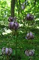
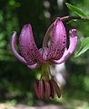
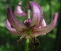
Practically all types of forest ( high forest , medium forest , coppice forest ) and forest types ( coniferous forest , mixed forest , deciduous forest ) can be found on the Hesselberg . The coppice forest in the upper regions of the northern slope has the strangest forest appearance. After a stroke of the stick , a lot of light comes to the forest floor, then warmth-loving animals like the sand lizard feel particularly at home here. Later, when the canopy closes again, other specialists, such as the woodcock , find a suitable habitat here. All types of game that are typical of German forests are represented in the forests of the Hesselberg ( brown hare , deer , fox , squirrel and others). The drumming of the woodpeckers and the call of the cuckoo are just as much a part of the forest atmosphere as the singing of countless birds. Various buttercups such as liverworts and wood anemones are heralds of spring in the Hesselberg forests. In May, the wild garlic transforms the soils of the deciduous forests into a green and white carpet of flowers. After flowering, this plant has an intense garlic-like odor in the air. Various orchid species such as the red forest bird have become much rarer . Orchids are not uncommon. The Turkish League , which belongs to the lily family, can still be found relatively frequently. The variety of this very sensitive flower is particularly interesting. The heather and the broom prefer the layers of iron sandstone in the lower areas of the slopes.
- Variations of the Turkish lily in the deciduous forests of the Hesselberg


Sporting events
- In 2008 the Hesselberg formed the final ascent of the second stage of the most important German cycling stage race, the Germany Tour . The finish line was below the summit at 595 m and counted as a third category climb.
- Since the tour through Germany, the so-called Tour de Hesselberg has taken place annually, where cyclists, runners and skaters have to conquer up to 450 meters in altitude on the Hesselberg over various distances.
The Hesselberg as a film set
The Werner Herzog film Everyone for Himself and God Against All from 1974 contains a sequence at the beginning in which Kaspar Hauser is carried on the back of a man from his dungeon out into the city. There you can see the actors on the Gerolfinger Berg walking from east to west, with the camera facing south over the Oettinger Forest. Then they walk to the stone stairs above the "Black Spruce" and experience the sunset there.
Sagas and stories
It is not surprising that there are so many sagas and legends entwined around such a peculiar mountain with so much history and stories . Parallels to the real history of wars and castles can be seen. Superstition, fear, and imagination undoubtedly contributed greatly to the genesis of these legends. In the thunder and lightning of heavy thunderstorms, the inhabitants recognized eerie figures and ghosts in the remains of the wall of the ruins, which they brought in connection with the former castle inhabitants. The remains of the wall of the ruins, which were later removed for further use as building material, reinforced the idea that the castles had sunk into the mountain. From the large number of Hesselberg sagas, the following three examples:
The legend of the devil's hole

A long time ago some boys were tending sheep on the Hesselberg. At that time there was a deep cave on the mountain that has since been buried. Plagued by curiosity, the boys wanted to know what was in this cave. So one of them was lowered into the deep hole with a rope. Before that, the boys decided that they would pull him up as soon as he pulled the rope. As soon as the boy was in the cave, however, a three-legged hare hobbled across the path. On the spur of the moment, the boys ran after the hare to catch it. But the further they ran after him, the faster the rabbit got. Eventually they gave up the hunt. When they got back to the cave, they remembered their friend in the cave. They quickly pulled up the rope. This was stained with blood and at the end of it hung a goat foot. However, the boy was gone forever.
The mountain spirit
It is said that a long time ago there was a huge castle on the Hesselberg. The lord of the castle lived in this castle with his only daughter. The girl ran the household for her father and had the keys to all rooms in the entire castle. At this time, the Huns also invaded the Hesselberg region. They destroyed the castle and burned it down. The girl was killed within the walls. It is said that she still haunts the mountain with her key ring on her belt. She is mostly seen on the Saturday night after the four quarters .
The unredeemed virgins from Schlößleinsbuck
The locals say that the ghosts of three cursed virgins live on the Schlößleinsbuck. Two of them are dressed entirely in white, but the third is wearing a black skirt. The three virgins appeared to a servant who was tilling the field near the mountain and begged him to follow them into the mountain in order to redeem them there. Since he is pure of heart, he does not need to fear the evil forces of the dark. They told him that on the way into the mountain they would meet six men who were sitting around a table with beards reaching to the ground. In the second room a black dog with fiery eyes will crouch with a key in its mouth. The servant must take this key, even if the dog is breathing fire. With this key he comes into a chamber with a huge treasure, which would then belong to him. However, the servant was terrified and left the virgins unsaved. It goes on to say that even today the virgins address brave men who are to follow them into the mountain so that they can be redeemed.
See also
literature
- Johann Schrenk, Karl Friedrich Zink , Walter E. Keller: From the Hahnenkamm to the Hesselberg , pictures of a Franconian cultural landscape. Keller, Treuchtlingen 2000, ISBN 3-934145-06-X .
- Arthur Berger: The Hesselberg. Finds and excavations until 1985 , Lassleben, Kallmünz 1994, ISBN 3-7847-5066-4 .
- Hermann Schmidt-Kaler: From the New Franconian Lake District to the Hahnenkamm and Hesselberg , walks into the history of the earth. Vol. 3. F. Pfeil, Munich 1991, ISBN 3-923871-58-9 .
- Albert Schlagbauer: The Hesselberg between Franconia and Swabia , Steinmeier, Nördlingen 1980, ISBN 3-923645-12-0 .
- Albert Schlagbauer: The Frankenhöhe, in the upper Wörnitzgrund, in the valley of the Sulzach, around the Hesselberg , Steinmeier, Nördlingen 1988, ISBN 3-923645-94-5 .
- Schlagbauer Albert, Fischer Adolf: Around the Hesselberg , Fränkisch-Schwäbischer Heimatverlag, Oettingen 1965
- August Gabler: The Alemannic and Franconian settlement of the Hesselberg landscape , Augsburg 1961, ISBN 3-922518-04-4 .
- Heinrich Grimm: People around the mountain , Ein Hesselberg novel (homeland novel about the Thirty Years War). Brügel, Ansbach 1932 (new edition Ansbach 1977), ISBN 3-88388-007-8 .
- Gerfrid Arnold: Behind the Devil's Wall: Sagen, Spuk, Legenden between Dinkelsbühl and Wassertrüdingen , self-published, Dinkelsbühl 1999
- Karl Grünwald: Visible traces of history in the land around the Hesselberg , Verlag Reinhard Wagner, Nuremberg 2002, ISBN 3-930349-05-1 .
- Schrenk-Verlag, Frank Baumeister: Hesselbergland , land and people in Ehingen, Dambach and Lentersheim, ISBN 3-924270-21-X .
- Thomas Greif: Franconia's brown pilgrimage. The Hesselberg in the Third Reich. Historical Association for Middle Franconia, Ansbach 2007 (= Middle Franconian Studies. Volume 18), ISBN 978-3-87707-698-9 .
- Thomas Greif (ed.): The Hesselberg: A cultural history. Schrenk, Gunzenhausen 2011, ISBN 3-924270-77-5 .
- Middle Franconian local history, Volume 1, Alfred Kriegelstein sagas, legends, stories from Middle Franconia , Verlagsdruckerei Heinrich Delp GmbH, Bad Windsheim 1983: The sunken castle on the Hesselberg , p. 37–38, The treasure in Hesselberg , p. 38–40
Web links

- Touristikverband Hesselberg e. V.
- Development company Region Hesselberg mbH
- Landscape Management Association Middle Franconia (Project Day for the Mountain )
- Find Hesselberg
- View of the Alps from the Hesselberg
Individual evidence
- ↑ The 723.1 m high Wöllerstein is located immediately west of the A 7 south of Westhausen - Reichenbach
- ↑ Dominance and prominence according to TK 25 with the help of Elevation Contours in Google Maps ; the saddle is at 456 m .
- ↑ Height of the Hesselberg without specifying the reference height according to the information board on the Hesselberg path photographed in 2005
- ↑ Map services of the Federal Agency for Nature Conservation ( information ) - the main units in the map service for protected areas can be activated.
- ↑ Bavaria's most beautiful geotopes, Hesselberg (accessed November 2, 2017)
- ^ Bavarian State Office for the Environment, Geotop former. Quarry on the Hesselberg NE of Gerolfingen (accessed November 2, 2017).
- ↑ Bavarian State Office for the Environment, Geotope Dogger Aufschluss am Hesselberg NW von Wittelshofen (accessed on November 2, 2017).
- ^ Protestant education center Hesselberg
- ↑ Touristikverband Hesselberg
- ↑ Franconian Moststrasse
- ^ German Alpine Club Section Hesselberg
- ↑ deutschland-tour.de ( Memento from September 22, 2014 in the Internet Archive ) Route of the Deutschlandtour 2008
- ↑ hesselberg.de "Tour de Hesselberg"