
Administrative community Hesselberg
| coat of arms | Germany map | |
|---|---|---|
 Help on coat of arms |
Coordinates: 49 ° 5 ' N , 10 ° 32' E |
|
| Basic data | ||
| Existing period: | 1978– | |
| State : | Bavaria | |
| Administrative region : | Middle Franconia | |
| County : | Ansbach | |
| Area : | 113.93 km 2 | |
| Residents: | 5772 (Dec. 31, 2019) | |
| Population density : | 51 inhabitants per km 2 | |
| License plate : | AN , DKB, FEU, ROT | |
| Association key : | 09 5 71 5509 | |
| Association structure: | 5 municipalities | |
| Association administration address : |
Wittelshofener Str. 30 91725 Ehingen |
|
| Website : | ||
| Chairman of the administrative association : | Friedrich Walter | |
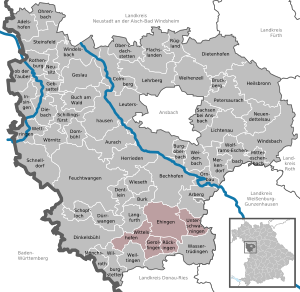
| Location of the administrative community Hesselberg in the district of Ansbach | ||
  |
||

In the administrative community of Hesselberg in the Central Franconian district of Ansbach , the following communities have come together to handle their administrative business:
- Ehingen , 1913 inhabitants, 47.62 km²
- Gerolfingen , 968 inhabitants, 12.59 km²
- Röckingen , 726 inhabitants, 10.91 km²
- Unterschwaningen , 881 inhabitants, 18.58 km²
- Wittelshofen , 1284 inhabitants, 24.23 km²
The administrative association is based in Ehingen.
The municipality of Langfurth belonged to the administrative community until December 31, 1979 .
Individual evidence
- ↑ "Data 2" sheet, Statistical Report A1200C 202041 Population of the municipalities, districts and administrative districts 1st quarter 2020 (population based on the 2011 census) ( help ).
- ↑ Dismissal by law on changing the membership of municipalities in administrative communities of 10 August 1979 ( GVBl p. 223)
Administrative communities in the Ansbach district
Dentlein am Forst | Hesselberg | Rothenburg ob der Tauber | Schillingsfürst | Triesdorf | Weihenzell | Wilburgstetten | Wolframs-Eschenbach
Resolved: Flachslanden | Lehrberg | Lichtenau