
Administrative community Triesdorf
| coat of arms | Germany map | |
|---|---|---|
 Help on coat of arms |
Coordinates: 49 ° 12 ' N , 10 ° 39' E |
|
| Basic data | ||
| Existing period: | 1980– | |
| State : | Bavaria | |
| Administrative region : | Middle Franconia | |
| County : | Ansbach | |
| Area : | 36.87 km 2 | |
| Residents: | 3889 (Dec. 31, 2019) | |
| Population density : | 105 inhabitants per km 2 | |
| License plate : | AN , DKB, FEU, ROT | |
| Association key : | 09 5 71 5506 | |
| Association structure: | 2 municipalities | |
| Association administration address : |
Triesdorfer Strasse 8 91746 Weidenbach |
|
| Website : | ||
| Chairman of the administrative association : | Willi Albrecht ( Free Voting Group / Weidenbacher List ) | |
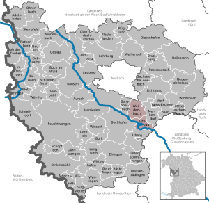
| Location of the Triesdorf administrative community in the Ansbach district | ||
  |
||

In the administrative community of Triesdorf in the Central Franconian district of Ansbach , communities have come together to handle their administrative business.
Members
Since January 1, 1980, the administrative community has included:
- Ornbau , town with 1619 inhabitants, 15.16 km²
- Weidenbach , market , 2270 inhabitants, 21.71 km²
Seat
The administrative community is based in Weidenbach , named after Triesdorf , the former summer residence of the Margraves of Ansbach-Bayreuth .
Original planning
A proposal by the Ansbach District Office from March 1973 envisaged an administrative community of Triesdorf with the towns and communities of Burgoberbach , Weidenbach with Großbreitenbronn , Merkendorf with Hirschlach , Wolframs-Eschenbach with Biederbach and Selgenstadt , Ornbau and Arberg with Lellenfeld .
founding
From its establishment on May 1, 1978 to December 31, 1979, the administrative community actually consisted of the towns of Merkendorf, Ornbau and Wolframs-Eschenbach, the markets of Arberg and Weidenbach and the community of Mitteleschenbach .
Dissolution and reorganization
With effect from January 1, 1980, the corporation was dissolved. Ornbau and Weidenbach formed the new administrative community of the same name. Wolframs-Eschenbach and Mitteleschenbach were merged to form the Wolframs-Eschenbach administrative community. The city of Merkendorf and the market in Arberg became unitary communities with their own administration.
Individual evidence
- ↑ "Data 2" sheet, Statistical Report A1200C 202041 Population of the municipalities, districts and administrative districts 1st quarter 2020 (population based on the 2011 census) ( help ).
- ^ Wilhelm Koch , Heinrich Helmreich: The municipal area reform. In: Merkendorf - historic small town in the Franconian Lake District. Merkendorf 1988, p. 104.
- ^ Official register of places for Bavaria, territorial status: May 1, 1978, issue 380 of the contributions to the statistics of Bavaria
- ↑ Law on the change in the membership of municipalities in administrative communities of 10 August 1979 ( GVBl p. 223)
Dentlein am Forst | Hesselberg | Rothenburg ob der Tauber | Schillingsfürst | Triesdorf | Weihenzell | Wilburgstetten | Wolframs-Eschenbach
Resolved: Flachslanden | Lehrberg | Lichtenau