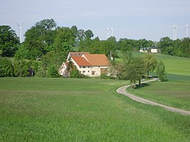
Simonsmühle (Gnotzheim)
|
Simonsmühle
Coordinates: 49 ° 4 ′ 21 ″ N , 10 ° 42 ′ 49 ″ E
|
|
|---|---|
| Height : | 441 m |
| Residents : | 9 (Jun 30, 2011) |
| Postal code : | 91728 |
| Area code : | 09836 |
|
Simonsmühle
|
|
As a former watermill, the Simonsmühle is a district of the Gnotzheim market in the central Franconian district of Weißenburg-Gunzenhausen in Bavaria .
location
The wasteland is north of Gnotzheim at an altitude of 441 m above sea level on the Wurmbach , also called Gnotzheimer Mühlgraben here . The Gunzenhausen districts of Nordstetten and Steinacker are to the northwest and northeast .
traffic
To the former mill, a road branches off from the federal highway 466 in a westward direction, which continues to Nordstetten or the Gnotzheim district of Weilerau .
Place name interpretation
The place name researcher Robert Schuh interprets the name as "Simon's mill", although he could not prove a mill owner of this name.
history
The mill is mentioned for the first time in an Oettingschen document from around 1370 , where it says that taxes are to be paid from the “Nider mül” to the Oettingsche Amt of Spielberg (in contrast to the Obermühle, the “ Rangmühle ”). The Salbuch of the Oettingschen office Spielberg, created after 1657, names the mill by Hans Nider, who is referred to as "Vnter Müller". In 1719 and 1739 it was referred to as "Nordstettenermühl"; Nordstetten is in the immediate vicinity of the mill. In 1764 the miller Huber lived on the mill. Until 1802 the miller Johannes Brand managed the Simonsmühle. In 1807 there is again talk of the "Untern Mühl" on which Xaver Meyer is sitting. For 1808 it is said that Caspar Pfuff from Filchenhard holds the Simonsmühle, on which Xaver Meyer had previously sat. In 1823, Xaver Meyer sold the mill to master miller Anton Bauer from Herblingen near Fremdingen . In 1833 the "Simons- or Untermühl" is listed under the Weilerau house number 10.
At the end of the Holy Roman Empire it was said that the subject family on the mill was subordinate to the Oberamt and High Court of Spielberg and belonged to the Catholic parish Gnotzheim. In 1806 the mill came to the Kingdom of Bavaria and in 1808 it was added to the tax district Gnotzheim in the district court of Heidenheim , to which Gnotzheim itself, Spielberg, Weilerau and the Letzleinsmühle still belonged. This tax district was converted into the Ruralgemeinde (rural community) Gnotzheim in 1811 . In 1818 it became a market .
1832 it was said from the mill to two millstones and a Lohgang ( Gerbgang had).
In 1842 Gnotzheim became an independent rural community with the two mills and Weilerau, with the departure of Spielberg. The regional reform in Bavaria did not change anything about this - except that Spielberg came back to Gnotzheim on April 1, 1971 and the Gnotzheim community and with it the Simonsmühle since July 1, 1972 in the enlarged Weißenburg-Gunzenhausen district (with the original name Weißenburg district in Bavaria) lies.
Today the place consists of the two properties Simonsmühle 1 and Simonsmühle 2.
Population numbers
- 1818: 2 inhabitants
- 1824: 4 inhabitants, 1 property
- 1829: 2 inhabitants
- 1855: Master miller Anton Bauer
- 1867: 3 residents, 3 buildings
- 1950: 4 residents, 1 property
- 1961: 5 residents, 1 residential building
- 1979: 5 inhabitants
- 1987: 7 inhabitants
- June 30, 2011: 9 inhabitants
literature
- Historical Atlas of Bavaria. Francs . Row I, Issue 8: Gunzenhausen-Weißenburg . Edited by Hanns Hubert Hofmann. Munich 1960, pp. 162, 233
- Robert Schuh: Gunzenhausen. Former district of Gunzenhausen . Series of Historical Place Name Book of Bavaria. Middle Franconia, Vol. 5: Gunzenhausen. Munich: Commission for bayer. Landesgeschichte 1979, especially No. 253, p. 269f
Individual evidence
- ↑ Schuh, p. 270
- ↑ Stan District Court Heidenheim 235/12
- ↑ a b c StAN LG a.O. Heidenheim basic files Weilerau No. 10
- ↑ This section after Schuh, pp. 269f.
- ↑ Historical Atlas, p. 162
- ↑ a b c d Historical Atlas, p. 233
- ^ Repertory of the topographical atlas sheet Dinkelsbühl , 1832
- ↑ Historical Atlas, pp. 233, 239
- ^ Wilhelm Volkert (ed.): Handbook of Bavarian offices, communities and courts 1799–1980 . CH Beck, Munich 1983, ISBN 3-406-09669-7 , p. 477 .
- ^ Hohn, Rezatkreis, 1829
- ↑ Centralbl. d. agricultural Verein in Bayern 45 (1855), p. 174
- ↑ J. Heyberger and others: Topographical-statistical manual of the Kingdom of Bavaria together with an alphabetical local dictionary. Munich 1867, column 1037
- ^ Official register of places for Bavaria 1964 with statistical information from the 1961 census. Munich 1964, column 784
- ^ Schuh, p. 269
- ^ Genealogy network
- ^ Website of the Gnotzheim market


