Spielberg (Gnotzheim)
|
Spielberg
Gnotzheim market
|
|
|---|---|
| Coordinates: 49 ° 2 ′ 47 ″ N , 10 ° 43 ′ 10 ″ E | |
| Height : | 538 (520-590) m |
| Residents : | 130 |
| Incorporation : | April 1, 1971 |
| Postal code : | 91728 |
| Area code : | 09833 |
|
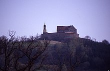
Spielberg with castle
|
|
Spielberg is a district of the Gnotzheim market in the Weissenburg-Gunzenhausen district in Central Franconia . The church village has about 130 inhabitants and is at an altitude of 520 to 590 meters above sea level.
geography
Spielberg is one and a half kilometers south of Gnotzheim on the Hagbucks, which is partly wooded on its slopes, on the northern edge of the Hahnenkamm , a foothill of the southern Franconian Jura . There are several springs in the area. The next towns are Wassertrüdingen and Gunzenhausen , both about eight kilometers away.
The district road WUG 25 leads through the village with a connection to the federal road 466 .
history
In the course of the municipal reform , Spielberg lost its independence on April 1, 1971 and was incorporated into Gnotzheim.
Attractions
The Spielberg Palace , which was renovated by the artist Ernst Steinacker from 1983 to 1988 and where he worked until his death in 2008, is visible from afar .
Web links
Individual evidence
- ↑ Internet site of the community Gnotzheim ( Memento of the original from July 19, 2011 in the Internet Archive ) Info: The archive link was inserted automatically and has not yet been checked. Please check the original and archive link according to the instructions and then remove this notice.
- ^ Wilhelm Volkert (ed.): Handbook of Bavarian offices, communities and courts 1799–1980 . CH Beck, Munich 1983, ISBN 3-406-09669-7 , p. 477 .


