
Main-Neckar-Rhein-Weg
.PNG)
The Main-Neckar-Rhein-Weg or Baden-Württemberg hiking trail is a 540-kilometer long- distance hiking trail that was created in 1978 on the occasion of the 25th anniversary of the state of Baden-Württemberg . It leads from the former Baden Wertheim am Main over the Württemberg and Hohenzollern area to the cities of Esslingen , Tübingen and Villingen-Schwenningen am Neckar . Then it goes back to Baden to the end point Lörrach am Rhein .
From Wertheim to Villingen-Schwenningen, the path is also the main hiking trail 3 (HW 3) of the Swabian Alb Association . The further stretch to Lörrach is looked after by the Black Forest Association.
Route

The Main-Neckar-Rhein-Weg begins in Wertheim and initially follows the course of the Tauber upstream via Tauberbischofsheim and Bad Mergentheim to Weikersheim . Now it goes south over the Hohenlohe level . In Langenburg is Jagst reached at Schwäbisch Hall the cooker .
The hiker comes through the Swabian Forest to Lorch an der Rems and the Roman Limes . The route now heads west and reaches the Neckar for the first time near Esslingen. The Baden-Württemberg hiking trail follows the course of the river and reaches the old university town of Tübingen at the former Cistercian abbey of Bebenhausen .
Behind Rottenburg , the Main-Neckar-Rhein-Weg leads to the Swabian Alb . About Hechingen and Hohenzollern Castle is Albtrauf reached. This is where the path joins the Swabian Alb Northern Edge Path (main hiking trail 1) and leads over several of the highest mountains in the Alb: Plettenberg , Oberhohenberg and Lemberg .
The Baden-Württemberg hiking trail leaves the Swabian Alb at Dreifaltigkeitsberg and heads towards the Black Forest via Spaichingen and Villingen-Schwenningen . In the valley of the Breg it goes up to Furtwangen . Shortly thereafter, the Rhein-Neckar-Main-Weg reaches the Westweg of the Black Forest Association, which it now follows.
The hiker reaches the Feldberg via Titisee-Neustadt and the Titisee . Now the eastern variant of the Westweg continues over the Herzogenhorn , Blößling , Hochkopf and Hohe Möhr . Past Schopfheim , the Baden-Württemberg hiking trail reaches its end in Lörrach am Rhein.
mark
Continuous marking of the Baden-Württemberg hiking trail is a stylized green tree on a stylized green hill with a red bar at the bottom.
Between Wertheim and Villingen-Schwenningen, the path also functions as main hiking trail 3 of the Swabian Alb Association and is therefore marked with a red crossbar on a white background according to the scheme of these main hiking trails. Usually, but not always, the designation "HW 3" can be found in black below or above the bar.
The red diamond on the Westweg serves as a marker between Furtwangen and Lörrach.
Sights along the way
- In the first part of the route, the path connects several well-known castles and palaces in Baden-Württemberg: Wertheim, Gamburg , Bad Mergentheim, Weikersheim , Landenburg and the Comburg near Schwäbisch Hall .
- Medieval townscapes, especially of Schwäbisch Hall and Esslingen am Neckar

View of the castle in the former free imperial city of Esslingen am Neckar
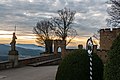
View from Hohenzollern Castle to the Albtrauf


literature
- Reinhard Leska: Main-Neckar-Rhine. Baden-Wuerttemberg hiking trail. German hiking publisher Dr. Mair & Schnabel & Co., Stuttgart 1981, ISBN 3-8134-0144-8 .
- Bernd Matthes: Baden-Württemberg hiking trail. Main-Neckar-Rhine. Südwest-Touristik-Förder-GmbH, Heilbronn 1981 DNB 830337709
- Bernd Matthes: The Baden-Württemberg hiking trail. In The Long Distance Wanderer. Zeitschrift für Weit- und Fernwanderer, Trekker and Hiker No. 2, April 1990, pp. 5-7
Web links
- Main-Neckar-Rhein-Weg (HW 3) at the Swabian Alb Association
HW 1: Swabian Alb North Edge Path | HW 2: Swabian Alb South Rim Trail | HW 3: Main-Neckar-Rhein-Weg | HW 4: Main-Danube-Bodensee-Weg | HW 5: Black Forest-Swabian-Alb-Allgäu-Weg | HW 6: Limes hiking trail | HW 7: Swabian-Alb-Upper Swabian Way | HW 8: Frankenweg | HW 9: Heuberg-Allgäu-Weg | HW 10: Stromberg-Swabian Forest Path | Georg-Fahrbach-Weg (GFW) | Württemberg Wine Trail (WWW) | Neckarweg | Lake Constance circular route | Main-Danube-Way | Upper Swabian Way of St. James | Franconian-Swabian Way of St. James