
Swabian Alb Upper Swabian Way
| Swabian Alb Upper Swabian Way | |
|---|---|
 Castle church in Friedrichshafen on Lake Constance |
|
| Data | |
| length | approx. 240 km |
| location |
Baden-Württemberg Swabian Alb , Upper Swabia |
| Supervised by | Swabian Alb Association |
| Markers |
Red bar, e.g. T. with inscription "HW7" |
| Starting point |
Lorch Abbey 48 ° 47 ′ 55.5 ″ N , 9 ° 42 ′ 11.4 ″ E |
| Target point | Friedrichshafen ferry port 47 ° 39 ′ 15 ″ N , 9 ° 28 ′ 45 ″ E |
| Type | Long-distance hiking trail |
| Height difference | 556 m |
| The highest point |
844 m above sea level NHN (Westenberg near Westerheim ) |
| Lowest point | 288 m above sea level NHN ( Lorch ) |
| Level of difficulty | medium |
| season | Spring to autumn |
| Months | April to October |
The Schwäbische-Alb-Oberschwaben-Weg is the main hiking trail 7 (HW 7) of the Swabian Alb Association . With a total length of 240 kilometers, it runs from Lorch im Remstal via Göppingen and Bad Saulgau to Friedrichshafen and leads through seven districts of Baden-Württemberg from the Swabian Forest via the Swabian Alb through Upper Swabia to Lake Constance .
Significance in the road network of the Albverein
The Swabian-Alb-Oberschwaben-Weg serves, in combination with the Miltenberg - Lorch des Limes hiking trail , as a north-south axis through Baden-Württemberg and thus forms the backbone of the main hiking trails of the Albverein. Due to its route, the Swabian-Alb-Oberschwaben-Weg comes into contact with almost all other main hiking trails as the only main hiking trail of the Swabian Alb Association. In Lorch next to the Limes hiking trail and HW 10 with HW 3 , with which it shares part of the route. From the Boßler to the Eckhöfe, the route runs simultaneously to the Nordrandweg . In huts he crosses the Südrandweg , in Lautertal and once again on the bus he meets HW 5 . In Friedrichshafen, it shares a short stretch of the way with HW 9 , and HW 4 also ends at the ferry port. Of the ten main hiking trails, only the Frankenweg does not come into contact with HW 7.
Other well-known hiking trails that HW 7 crosses or partially follows are the Burgen-Weg over the Swabian Alb, the Bodensee-Rundweg , the Ehinger Alb reflection trail , the Jubiläumsweg Bodenseekreis , the Remswanderweg and the Remstal-Höhenweg as well as the Jakobswege in the Göppingen area and Upper Swabia.
Of the ten main hiking trails of the Albverein, the Swabian-Alb-Oberschwaben-Weg is the seventh longest.
history
In 1976, at the Gauwegemeistertagung, it was decided to expand the existing main hiking trails ( Swabian-Alb-Nordrand-Weg and Swabian-Alb-Südrand-Weg ) by a further eight main hiking trails. The aim was to structure the hiking trail network more strongly, to summarize it and to make it more attractive.
In 1978 the new main network of hiking trails was planned. The selection was made according to landscape and historical criteria. After the hiking trails were accepted at the main trail meeting in 1979, the trail network was presented to the main committee at the general meeting of the Swabian Alb Association in Aalen on June 9, 1979, and finally approved.
The Swabian-Alb-Oberschwaben-Weg was set as the main hiking trail 7. In combination with the Limes hiking trail (HW 6) starting in Miltenberg, it is intended as a so-called “middle path” through Baden-Württemberg from north to south. Its starting point was therefore set at the "bend" of the Upper German Limes Trail at the Lorch monastery parking lot.
The main focus of route planning was on the culture and landscape of Upper Swabia. As with most of the other main hiking trails laid out during this period, the waymarking was largely based on existing Albverein trails, and these were upgraded to the main hiking trail by being re-marked.
The marking of the 200 km long hiking trail was completed within three years. An official inauguration did not take place.
Route
The Swabian-Alb-Oberschwaben-Weg begins in Lorch and leads south over the Hohenstaufen with its castle to Göppingen. At Bad Boll you reach the eaves of the Swabian Alb and climb it with the Boßler . The path touches the UNESCO Swabian Alb biosphere area and meets the Swabian Alb northern edge path , HW 1. Together with it, it runs south until the paths separate again shortly before the Reußenstein ruins . The further way across the Alb touches Wiesensteig , Laichingen and Hütten . There he crosses the Swabian-Alb-Südrand-Weg , HW 2. Then it continues through the Lutheran Mountains , and near Obermarchtal the hiker arrives at the southern edge of the Swabian Alb.
The main hiking trail 7 crosses the Danube at Zwiefaltendorf and leads on the distinctive buses . The next stop is Bad Buchau am Federsee . The path roams the Upper Swabian landscape, touches Bad Saulgau , Altshausen and Wilhelmsdorf . Then the path runs through the hilly moraine landscape of the Linzgau , brushes against the highest and crosses the Gehrenberg . Passing Markdorf you reach the end point Friedrichshafen. The hiking trail ends at the ferry port to Romanshorn .
mark
The path is marked with a red crossbar on a white background according to the main hiking trails of the Swabian Alb Association. Usually, but not always, the designation "HW 7" can be found in black below or above the bar.
The local groups of the Albverein are responsible for the marking. The continuous marking begins at Lorch train station from the hiking board for the Lorch local group, which sometimes means that the beginning of the hiking trail can be viewed from there. From Lorch Abbey to the train station, the route follows the Main-Neckar-Rhein-Weg , a stylized green tree on a stylized green hill.
In some cases, conventional signposts are still used that were installed by the Albverein from the 1960s. In the district of Ravensburg and in the Lake Constance district, the new uniform signposts decided in 2012 have already been set up. For the Alb-Donau district it was planned to complete the new signage concept by the end of 2015, but new path markings were set on the Ehinger Alb in August 2017.
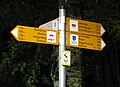
A modern guidepost in the Lake Constance district

Hiking pass and hiking pin
By the then main roads champion Karl-Heinz Lautenschlager early 1990s created a hiking pass and hiking pin for all main trails. The hiking pass contains fields for control stamps and serves as proof of the hiked route. Upon presentation of the fully completed hiking pass and a processing fee of 5 euros, a certificate and a hiking pin will be handed out.
The needle for the Swabian-Alb-Oberschwaben-Weg shows the castle church in Friedrichshafen.
In contrast to other hiking trails (such as the Harz hiking pin ), there are no official stamps on HW 7. The evidence is provided via hikers' homes, inns, tourist offices or the like. In some cases, the stamp of the Göppingen Jakobsweg (Hohenstaufen, Göppingen) or the Upper Swabian Jakobsweg (Heratskirch, Markdorf) can be used.

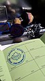
Hiking pass with control stamp
Stamp point of the Way of St. James in Hohenstaufen
.jpg)

Sights along the way
- In the first part: Hohenstaufen Castle and Göppingen
- The path across the Alb touches five remarkable caves: the Schertelshöhle , the Laichinger Tiefenhöhle , the Sontheimer Höhle , the Karls- und Bärenhöhle and the Zwiefaltendorfer stalactite cave .
- The stations of the Upper Swabian Baroque Road all require a detour: the Obermarchtal Abbey Church, Sießen Abbey near Bad Saulgau and Hofen Abbey near Friedrichshafen.
- Stations on the Swabian Baths Road : Bad Buchau and Bad Saulgau
literature
- Willi Beck: HW 7 Swabian Alb - Upper Swabia, HW 9 Heuberg - Allgäu. Konrad-Theiss-Verlag, Stuttgart 1984, ISBN 3-8062-0393-8 .
Individual evidence
- ^ Willi Beck: New main hiking trails of the Swabian Alb Association. In: Leaves of the Swabian Alb Association. 5/1979, pp. 139ff.
- ↑ Willi Beck, Lit, p. 3 and minutes of the meeting of the main committee on June 5, 1982 in Münsingen
- ↑ New signposts for the Swabian Alb. on esslinger-zeitung.de on January 13, 2012, accessed on September 26, 2017.
- ^ Albverein and municipalities discuss new signposts. on swp.de from August 14, 2014, accessed on September 26, 2017.
- ↑ New signs for hiking trails on the Ehinger Alb. on swp.de from August 29, 2017; accessed on September 26, 2017
- ↑ a b Karl-Heinz Lautenschlager: Hiking pass for hiking fun. In: Leaves of the Swabian Alb Association. 6/1994, p. 178.
- ↑ Hiking pass and hiking pin on the website of the Swabian Alb Association
Remarks
- ↑ From north to south: Ostalbkreis , district Göppingen , Alb-Donau-Kreis , district Biberach , district Sigmaringen , district Ravensburg and Bodenseekreis
- ↑ However, the Frankenweg can be reached from Lorch via the Limes hiking trail, so that the idea of a central connection of all main hiking trails is maintained.
Web links
- Main hiking trail 7 at the Swabian Alb Association
HW 1: Swabian Alb North Edge Path | HW 2: Swabian Alb South Rim Trail | HW 3: Main-Neckar-Rhein-Weg | HW 4: Main-Danube-Bodensee-Weg | HW 5: Black Forest-Swabian-Alb-Allgäu-Weg | HW 6: Limes hiking trail | HW 7: Swabian-Alb-Upper Swabian Way | HW 8: Frankenweg | HW 9: Heuberg-Allgäu-Weg | HW 10: Stromberg-Swabian Forest Path | Georg-Fahrbach-Weg (GFW) | Württemberg Wine Trail (WWW) | Neckarweg | Lake Constance circular route | Main-Danube-Way | Upper Swabian Way of St. James | Franconian-Swabian Way of St. James